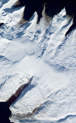
Winter satellite image, showing the ice cap and the main outlet glacier troughs. The Kaldalon valley runs towards the bottom left corner of the image. Note that the ice cap is asymmetrical -- the highest part is towards the eastern edge.
My old friend Dave Sugden has produced a little booklet based on his diary of the Oxford Icelandic Expedition 1960, which we jointly led and organized. (It was not exactly a gigantic undertaking. There were only 4 of us, but one has to start somewhere.......) We were in the field for a month, and the total cost was £360!! Anyway, very pleasant and nostalgic reading.
We worked hard while we were in the field, and our mapping (plane table and no theodolite) and observations led to our first ever publication, in the journal Geografiska Annaler. It was very descriptive and naive, but as I said, one has to start somewhere.......
I had forgotten the details of our trip onto the ice cap on 18 July 1960 -- our first experience of working with ropes and ice axes in crevassed terrain. We encountered no great hazards, but close to one of the summits on the ice cap we encountered a vast crevasse which we were not equipped to deal with. We were in thick cloud and working off compass bearings, with visibility around 20m. So then we had no option but to turn back. That was an 18-hour day, and we were all exhausted at the end of it.


Bing satellite image of Kaldalonsjökull -- early summer, when the upper part of the glacier is

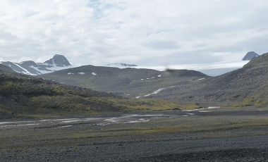
Bing satellite image of the Kaldalon Valley, where we worked intensively for a month in 1960.

Our 1960 map of the main features of the valley
Which was the most effective plane table in 1960 or using a theodolite in 1962?
ReplyDeleteI did a lot of plant table work in my early days, much of it is still in my attic. Theodolite survey seemed to take a lot of time to little real effect, especially in the early computer days. It seemed to be about chasing apparent accuracies, but not the whole picture. Now we are into digital drawings, the final results never seem to be completed, merely that it is easier to fudge the final result to make it look better.
I find the plane table has a huge advantage that it gives at least the outline of the the survey area on a piece of paper at the end of the survey day.
Hi Dave -- it seems as if we are talking about Stone Age technologies here! I don't suppose anybody uses a plane table any more, anywhere in the world, since satellite digital technology is universally accessible. But back in the olden days, it was horses for courses. I agree that a theodolite is a bit of a nuisance, and sometimes doesn't bring any great benefits. In Iceland we used a plane table and a telescopic alidade, and used simple triangulation, since our priority was the making of a reasonably accurate map of the features in our valley -- we did not even have access to decent air photos. The altitudes of things were not that important -- spatial relationships were what we were looking for. In Greenland, two years later, we were looking for strandlines and marine limits, so correct altitudes were crucial. We weren't so bothered with mapping or spatial accuracy. So we did many long transects -- we could have managed with other instruments, but the theodolite gave us the precision we needed. And we clearly got things just about right!
ReplyDeleteI did transition to compass bearing and pacing, which was good in its way, but good less accurate, the further you walked!
ReplyDeleteAltitudes are still maybe not critical in archaeology, certainly the spatial relationships are