THE BOOK
Some of the ideas discussed in this blog are published in my new book called "The Stonehenge Bluestones" -- available by post and through good bookshops everywhere. Bad bookshops might not have it....
To order, click
HERE

Thursday 30 September 2021

The SE edge of the Irish Sea Glacier


I have come to the conclusion that we have all been getting it wrong.  The edge of the Irish Sea Glacier in west Wales during the Devensian Glaciation or LGM was not wrapped around the Pembrokeshire coastline at all, but was much further east.  In fact, I now think that the whole of Pembrokeshire was inundated beneath glacier ice around 26,000 years ago.  This was all Irish Sea ice derived from far to the north, and from Ireland, but I'm still attracted to the idea that there was a stagnant or sluggish Preseli ice cap over the highest parts of the upland.

I have suggested this before, albeit with not much conviction.......

https://brian-mountainman.blogspot.com/2019/10/confusion-reigns-late-devensian-ice.html

https://brian-mountainman.blogspot.com/2020/10/the-lgm-in-west-wales-reappraisal.html

You can find many other posts by using the excellent search facility on this blog.

The ice edge maps in the literature are now so out of date, and indeed nonsensical from a glaciological standpoint, that they are best consigned to the dustbin.  Here are some of the dodgy ones (including some of mine!):

The BRITICE map showing the mooted LGM limit in west Wales, with the suggested ice-free area in mid and south Pembrokeshire and (in brown) the suggested pre-Devensian glacial deposits.

Carr et al, 2017 -- a map which inexplicably shows the Devensian limit in St Bride's Bay, in the vicinity of Rickets Head.  This is quite bizarre, as is the suggested ice flowline more or less parallel with the proposed ice edge to the west of Lundy.  Ice always flows perpendicular to unconstrained ice edges.

Some of the other limits to be found in the older literature......

My attempt to modify the LGM limit in order to incorporate all the fresh glacial deposits on the clifftops of south Pembrokeshire.

Here I have pushed the Devensian glacial limit further inland in order to incorporate apparently fresh inland deposits.

In blue, the Devensian limit as suggested by the BGS, and as printed on the geological map for the area. Parts of this seem quite accurate, but I'm now convinced that in the west, it is wrong.

 On this map Scourse et al (2021) have accepted my evidence from South Pembrokeshire (including Caldey Island) without acknowledging or citing it, and have reproduced my line.  That was a bit careless of them........... but they have my forgiveness.  I now think that the Pembrokeshire ice free enclave does not make sense.

So I no longer believe that there was an ice-free or permafrost enclave over central and eastern Pembrokeshire at the height of the Late Devensian glaciation.  And the reasons for my change of opinion?
The evidence: 

1.  There are far too many spreads of glacial and fluvio-glacial deposits in these areas deemed to be outside the LGM limit.  Some of them, at least, appear quite fresh, and some even have surface expression.  They are by mo means all "degraded or denuded" and are by no means restricted to hilltops or interfluves, as claimed by some.

2.  The glacial deposits in the valleys and on the clifftops of South Pembrokeshire are so abundant and so fresh that they have to be Devensian.   The exposures are itemised on this blog.  I now think that there are glacial deposits around Amroth and Marros as well; and these are best explained by ice pushing down from the west and the north, and not from the south.

Reddish till exposed at Ballum's Bay, Caldey Island.  I do not accept the interpretation by John Hiemstra and others that this is a redeposited ancient till.

3.  The glacial and fluvioglacial deposits around Picton Point and Landshipping, right in the centre of the county at the confluence of the two Cleddau rivers, cannot adequately be explained without invoking a complete ice cover across Pembrokeshire.   I have another report of fresh till near Haverfordwest.

4.  Over and again I have described on this blog glacial deposits and apparent trimlines at a variety of altitudes on the northern side of Preseli, up to an altitude of 340m.  It looks to me as if that was the altitude of the highest Devensian ice surface associated with Irish Sea ice.  If the ice covered Carn Ingli and pressed onto the northern flank of the Preseli ridge at that altitude, it would make no sense for the ice edge to be at or near present sea level around the mid and south Pembrokeshire coast.  Ice must have filled the Cwm Gwaun depression, and indeed I have described apparent morainic features above and on the south side of the meltwater channel, and at Cilgwyn and Tafarn y Bwlch.  Nor does it make any sense for an ice edge to be parked around the 200m contour in the vicinity of Wolfscastle and Letterston, as suggested by the BGS.  If the ice was coming in from the NW, it MUST have inundated the whole of Pembrokeshire to the south of Preseli, according to the laws of ice physics.  The ice edge might have been slightly lower on the southern flank of the Preseli ridge.  I now think that the assorted morainic ridges and glaciofluvial mounds in and around the Preseli uplands may be associated with retreat stages or short-lived readvances -- still to be defined.  

 None of this eliminates the possibility that there are Anglian or Wolstonian glacial and meltwater deposits in the area previously designated as an ice-free enclave.  As indicated on this blog, I think there are ancient glacial deposits at Ceibwr, Witches Cauldron and Black Mixen, Lydstep; and Prof Danny McCarroll and I are rather convinced that glaciofluvial gravels exposed at Llangolman may well be very old indeed. There is plenty to keep us occupied.

So there we are then.

=================

PS.  This is a somewhat relevant post, on the footprint of the Irish Sea Ice Stream:


PPS. What has all this to do with Stonehenge and the bluestones? Quite a lot, actually. This is from an earlier post, with a little modification:

Recent work on the glaciation of the Celtic Sea shelf by the Irish Sea Ice Stream has shown that the Devensian ice surface gradient was exceptionally shallow, dropping from +750m in the Irish Channel to +400m in St Georges Channel to -200m at the southernmost ice edge about 500 km away. That represents a surface drop of about 1000m over a distance of 500 km -- or 2m per km.  There must have been substantial lateral spreading and gradient reduction on the ice surface once it was clear of the constriction between North Pembrokeshire and the coast of SE Ireland. It was proposed by Prof Geoff Boulton many years ago that this was because of the soft and saturated sediment bed on what had been the sea floor, facilitating a high rate of bed deformation, lubrication and basal sliding. This has been confirmed by subsequent work by James Scourse and the BRITICE team. So could the ice from the west have surmounted the chalk escarpment on the edge of Salisbury Plain? Since the Plain has a surface altitude of 200m-250m, an ice front capable of surmounting the chalk scarp must have had a surface altitude of c 300m. That could not have happened in the late Devensian glaciation, but it would have been perfectly feasible in the Anglian, at a time when the whole of Preseli must have been deeply inundated by ice, with a glacier surface at c 750m. The soft sediments of the Somerset Levels would have facilitated ice movement eastwards from the Bristol Channel.  The drop in the surface of the ice lobe would have been 450m over a distance of 280 km -- namely 1.6m per km.  That's a reasonable ballpark figure, given that the deforming sediments in the Bristol Channel must have been very similar to those of the Celtic Sea, in both the Anglian and the Devensian glaciations, leading to a very similar style of glacier behaviour.  I will look at this topic again, in another post.

https://brian-mountainman.blogspot.com/2011/02/glaciological-dilemma.html

https://brian-mountainman.blogspot.com/2020/10/on-lateral-spreading.html

https://brian-mountainman.blogspot.com/2019/07/more-on-ice-gradients-in-celtic-sea.html


Wednesday 29 September 2021

The BRITICE-Chrono special edition

I don't think I have given the link to this "special publication" before.  So here it is:

 https://onlinelibrary.wiley.com/toc/10991417/2021/36/5

There are a number of long and detailed publications with multiple authors -- summarising many years of research work by this team.  On the whole, it's good stuff -- although as I have explained before I do not agree with everything, and wish they had done some more geomorphology and a little less computing.....

https://brian-mountainman.blogspot.com/2021/05/new-dating-for-lgm-irish-sea-ice-stream.html 

But a very welcome contribution, and it's good to see that most of the papers are open access, available as PDFs with just one click.........

On the scheduling of fantasy features


Pembroke Castle and Silbury Hill -- scheduled ancient monuments that probably do actually exist.  As for the "bluestone quarries" and the "lost circle", we have a problem...........

I have discovered that requests are in for the "ancient monument" scheduling of Craig Rhosyfelin and  Carn Goedog as Neolithic quarries and for the revision of the scheduling citation for Waun Mawn on the basis that there is a "lost stone circle" there.  These are the guidance notes published by Cadw:

https://cadw.gov.wales/sites/default/files/2019-07/Understanding%20Scheduling%20in%20Wales%20Cadw%20Eng%20WEB%20%281%29.pdf 

It's open to anybody to request the scheduling of a particular site or structure, but one can only assume that the requests in these three cases have come directly from MPP and his team.  This is a pretty extraordinary state of affairs, given that there is nothing visible at any of these sites to tell us what they are, or might have been.  All we have are some "interim reports" which have at last come to light, and some opinions articulated in three papers published in "Antiquity" journal. The other glossy articles and book chapters are just froth around the edges, issued for marketing purposes.   The flood of geological papers by Bevins and Ixer is entirely irrelevant in this case, since the publications tell us something about provenancing, but nothing at all about how stones and fragments were picked up and transported from A to B.

The only traces of human activity to have emerged from the digs between 2011 and 2021 relate to camping and hunting activities, and we can be sure that such traces would be discovered in any excavation adjacent to any prominent rocky crag anywhere in Wales, except maybe adjacent to very exposed locations in high mountain areas.  Prehistoric camp sites may be very interesting for students of the hunting and gathering economy, but I am not at all sure that they are worthy of ancient monument designation or of enhanced levels of protection.

Rhosyfelin is of course already protected to some degree, by a RIGS designation, and I think we have some reason to be concerned about the actions of the MPP digging team in destroying the sediment sequence at the site, removing and dumping hundreds of tonnes of deposits that were considered to be of no interest, and leaving the landforms at the site vastly changed from those that were originally encountered.  In other words, the site is considerably rearranged and damaged, and the diggers would not have got away with it if the RIGS designation had been in force at the time of the excavations.

At any rate, I hope we can count on Cadw and the other organizations involved to be very cautious indeed in their assessment of the requests that are now on file.  Powerful evidence of quarrying and "lost circle" construction will have to be brought forward, and I simply do not believe that such evidence exists.  

Cadw will not want its reputation to be sullied by getting caught up in hoaxes or pieces of fraudulent research work -- and they would look very foolish indeed if they were to schedule something that simply a figment of somebody's fertile imagination.   So they will look very hard at the hard "evidence" presented, and will ask for it to be submitted in detailed and archived final reports. Then they will consult widely and gather in as many independent opinions as they can.  They will certainly not be swayed by personal reputations, press coverage or TV programmes fronted by Alice Roberts.  There will be consultations on whatever they recommend.   The bar will be set very high.  Don't expect any decisions any time soon.

Even if these sites are scheduled -- which I think is highly unlikely -- there is scope for protests to be entered and for scheduling to be revoked.  So things could get very messy indeed........

Monday 27 September 2021

Waun Mawn 2021 -- what was discovered?


Was there a great oak tree at the centre of a magic circle?  Now wouldn't that be fun?

So what was discovered?  Not very much, by all accounts.

I have some reports on Prof MPP's annual lecture at the Bluestone Brewery -- which is traditionally the occasion on which great announcements are made.  The talk was on 14th September, just before the end of the dig -- so the main findings were certainly clear by then.  Some of the locals who have attended the Brewery talks in the past did not attend this year, partly because of Covid-related fears about social distancing etc and partly because they have heard it all before, several times.  I think a sort of bluestone fatigue has set in, and that appalling Alice Roberts TV documentary has also convinced many people that there is far too much speculation going on, backed up by too few facts.

Reports from those who did attend the talk suggest that the whole thing was very low-key, with no major announcements of exciting finds.  So the presence of the "lost circle" was not confirmed by the "discovery" of new sockets or stone holes, in spite of a very extensive search.  In fact the "lost circle" promotion was much more muted this time round, with a change in the language used.  The certainty of past lectures was replaced with phrases like "my best guess is...." and "we think it's possible that...."  One listener was quite surprised that there seemed to be an acceptance that the "lost circle" was an OPINION rather than an established fact.  Interesting........ and about time too.......  And the suggestion now seems to be that the mooted stone circle was never actually completed, let alone dismantled and carted off to Stonehenge.

The slight "embankment" with recumbent stones, to the north of the putative stone circle circumference, has by the look of it turned out to be entirely natural.

The embanked circle near Gernos-fach seems to be difficult to interpret, but it looks as if it is BronzeAge, as many of us have suggested -- and so it probably has nothing to do with either the Neolithic or Stonehenge.

My contacts don't recall anything interesting being said about the attempts to find standing stone sockets showing some sort of alignment with the rising sun on the summer solstice.  So it looks as if the diggers have drawn a blank there too. 

The only thing that seems to have sparked a murmur of interest appears to have been the "discovery" of ye olde oak tree somewhere near the centre of the putative lost giant circle.  That's where there was an excavation c 8m x 8m. Apparently a pit was found that seems to have been related to the rootstock of a large oak tree.  No stone socket and no post hole that might have been used with a rope for marking out the circumference.  So the latest theory seems to be that the builders of the circle (if there ever was one, or part of one) were tree worshippers who used a great oak tree as a focal point of their religious ceremonies or rituals and who wanted to place standing stones around it as a sort of homage. Ah -- the predecessors of the druids!  The story gets ever more wacky. 

Of course, as I have said on more than one occasion, the so-called stone sockets (ten of them, according to MPP) are so shallow and so irregular that they are best interpreted as natural hollows in a rough till surface -- or possibly as the locations of tree roots in the past. Mike Pitts and Tim Darvill seem to agree with me.   That interpretation would not be at all surprising, since this area was recorded in the Middle Ages as a deer park -- and that means it was densely wooded.  MPP wants us to believe that Waun Mawn was a past peat bog, covered with blanket peat -- but I don't believe that the evidence supports that, and it is much more likely that it was covered by woodland during much of the Holocene, with a later reversion to the dry acid heath vegetation that we see today.

There is a reasonable chance that the great oak tree (or maybe little oak tree?) that was rooted in this auspicious position has nothing at all to do with the Neolithic, but was growing there 4,000 years later, providing shelter for jolly huntsmen at the pleasure of one of the local Welsh princes or Norman barons.  All will be revealed when the radiocarbon dates and pollen analyses are available for scrutiny.


We assume that all the geological sampling, taking of peat cores for pollen analyses etc all went according to plan -- and will bring forth results that are of interest. But there is something pathetic about the pretence by the MPP team that they are still hunting for more bluestone quarries, and one can only hope that in future they will use their time and cash resources more constructively.

All in all, much ado about nothing.

PS.  Sorry if any of the above proves to be inaccurate -- but my correspondents were not as attentive as they might have been in the past......  If anybody reading this wants to correct me, please send in your comments and I will publish them.


Sunday 26 September 2021

The edge of Wordie Gletscher, East Greenland


 This is a fabulous image of a land-terminating glacier edge in NE Greenland -- Wordie Gletscher -- which has relatively clean ice and a narrow belt of small moraines just beyond its edge.  (Another part of the same glacier does terminate in the sea.)  That means that the ice is now retreating from a stillstand position.  Why does this glacier seem to transport so little debris?  The simple answer may be that it is frozen onto its bed -- and so should be called a cold-based or "polar" glacier.  But I suspect that the answer is a bit more complex than that......

Ceibwr-- a rather interesting pebble


This is one of the most interesting beach pebbles I have ever collected -- and I have picked up a fair number in my time.  Its maximum length is about 9 cms.  It's rough to the touch, but has a well-rounded shape and a rather spectacular colouring.  It was found on the beach at the head of Ceibwr Bay, and I know exactly where it has come from.  

It comes from the extraordinary deposit of cemented till at the entrance to the bay, which I suspect of being very old indeed -- maybe dating from the Anglian Glaciation.  This concreted till lies beneath the uncemented fresh till which I equate with the Irish Sea till as seen in Newport Bay and at Gwbert and Poppit in the Teifi Estuary. 

There are a few exposures of this old cemented till inside the bay itself, on its flanks, and here and there we can see that it roofs over gullies and small caves cut in the local shales and mudstones.  I assume that the roof of one such gully has collapsed, throwing this strange conglomerate material into the water, where waves and tides have done their work, washing fragments up onto the beach and rounding them in the process.

Very unusual and exciting! 

On diffluence: the Holger Danskes Briller trough in East Greenland

A recognition of diffluence and diffluent routes is critical in an understanding of glaciated landscapes.  In general, glaciers of all sizes will flow in troughs and will tend to straighten them if possible and to deepen them as they seek to discharge as much ice as possible -- as efficiently as possible.  A glacier (whether an outlet glacier or a valley glacier) will always flow in a valley or into a lowland in preference to overtopping a ridge or submerging an upland, until the depression is filled to overflowing.  But then,  if it is offered a col to flow over, it will normally take it, as long as there is no major blockage downstream.  In Greenland there are diffluent discharge routes all over the place, including many where we find a rectilinear pattern of troughs.  Sometimes, if the ice is able to enter a convenient diffluent discharge route, it may flow towards its own source area, rather than away from it.  It gets confusing...........  and at one stage of a glaciation the ice may flow one way, and then in the opposite direction at the time of peak glacierisation.

Topographic map of the Kjove Land - Syd Kap area, showing the diffluent trough with its two lakes.


View of the Holger Danskes Briller diffluent trough, seen from the east, across Nordostbugt.

One of the most beautiful diffluent troughs I know is in Kjove Land, East Greenland, where the ice of the Nordvestfjord outlet glacier has spilled over on its left flank just a few kilometres from the trough exit into Hall Bredning. The diffluent trough is now occupied by two elongated lakes which look like a pair of spectacles on a map -- hence the name Holger Danskes Briller.

Annotated satellite image from Bing Maps.  Perfect snow conditions for showing up the geomorphological features of importance!

This is from the article published by David Sugden and myself following our 1962 East Greenland expedition.  Quote:

The planed surface of the Holger Danskes terminal moraine, an accumulation c. 1 kilometre long and c. 700 metres wide, has an altitude of 101metres (Fig.4). It has kettle-holes in this surface, unsorted moraine on its western flank and shell-bearing mud-banks, sands and gravels on its seaward flank. In view of these characteristics it is improbable that the 101-metre sea level pre-dated or post-dated the formation of the moraine; it seems that the snout of the Holger Danskes glacier was actually depositing this impressive moraine during 101 metre times. Since the Holger Danskes Glacier flowed through a trough of glacial diffluence from the Nordvestfjord Glacier (a major outlet glacier of the Greenland Ice Cap) it is possible that the Kjove Land terminal moraines represent a widespread retreat stage in the East Greenland fjords.

The Raised Marine Features of Kjove Land, East Greenland. 

Most of the conclusions from that paper have been confirmed by later research.  The big moraine (shown as "Hjornemoraene" on the topographic map) near the south edge of the satellite image marks an important stillstand of the ice at the end of the last glaciation, with an uncertain date; but it does not mark the position of greatest ice extent, since there are many smaller moraines on the hillside above it, above the 200m contour.  These have been studied by a number of research teams since 1962, and are probably more than 12,000 years old.  The moraines are assumed to belong to the "Milne Land stage" by Svend Funder and later authors.  The marine limit in this area is at c 132 m above present sea level, and is dated to c 12,400 yrs BP.  In 1962 we identified washes moraine surfaces below this limit, and fresh moraine above it.  Some of the moraine ridges around Hjornemoraene are higher up the hillside above the marine limit, and they are therefore older. The big moraine and delta at the exit of the Holger Danskes Briller trough is later, and is dated as around 11,200 yrs BP, coinciding with an important sea-level stillstand during which many shoreline features including delta terraces were formed. These features were the focal points of our research in 1962.


Map from Funder (1972), showing the reconstructed Milne Land stage limits.  I don't think these are accurate for the Syd Kap area, since Kjove Land is shown as ice-free, located to the east of the Nordvestfjord Glacier edge.  The big moraines at Hjornemoraene are aligned more or less east-west, suggesting to me that the ice tongue in the diffluent trough was confluent with its parent glacier, making the Pythagoras Bjerg upland into a nunatak, surrounded by ice..........


Here is a map from Alexandersson and HÃ¥kansson 2014, which shows the mooted positions of the moraines of the Milne Land stage, with an outer limit some way to the east of the Schuchert Valley,  I think this must be contemporaneous with the high moraines in Kjove land, emplaced at a time when the Pythagoras Bjerg massif was a nunatak.  Date?  Maybe around 13,000 yrs BP..........  There is no trace on the satellite image of a prominent moraine ridge on the east side of the Schuchert Valley in the marked position -- but it makes sense for this to have been a floating ice-front, whereas those to the west were grounded ice edges. 


References:
Helena Alexanderson & Lena Håkansson (2014) Coastal glaciers advanced onto Jameson Land, East Greenland during the late glacial–early Holocene Milne Land Stade, Polar Research, 33:1, 20313, DOI: 10.3402/polar.v33.20313
https://doi.org/10.3402/polar.v33.20313

Hall, B.L., et al., Relative sea-level changes, Schuchert Dal, East Greenland, with implications for ice..., Quaternary Science Reviews (2010), 
doi:10.1016/j.quascirev.2010.03.013

Saturday 25 September 2021

Archaeology -- its own worst enemy?


Looks as if academic archaeology is in a seriously beleaguered state just now.  The article reproduced below is an interesting analysis containing some good points.  It's a bit naive, because it treats all archaeologists as heroes, and seems to think that archaeology takes no responsibility at all for what seems likely to be an uncomfortable fate.  

It says this:  "Archaeology faces a “perfect storm” of university cuts, skills shortages and potential changes to planning rules which threaten to irreversibly damage the UK’s world-leading reputation in the discipline, experts warn."  That, I think is very naive indeed -- there may be a perfect storm, but one of the components in it may well be the declining reputation of archaeology as a serious discipline with a respect for the scientific method and a carefully controlled and monitored way of operating.  This may well not be true of ALL academic archaeology, but some of it, at least, is so obsessed with storytelling and myth creation that it seems to be disinterested in maintaining any sort of reputation as a "discipline." 

 If very senior archaeologists appear to have lost their respect for hard evidence and the truth, in pursuit of their post-processual obsessions, why should they get any respect from either the public or from a new generation of students?  And why should they be funded by the research funding organizations if all they are going to produce are fantasies and myths? From where I stand, archaeology seems to be intent on the "dumbing down" of its curriculum and on appealing to the tabloid press and TV documentary makers rather than to the community of scientists. Colourful characters pursuing their own personal quests may make for good tabloid headlines and good TV ratings, but what are they doing to uphold academic standards?  How much RESPECT does archaeology have outside of its own little bubble?  Not much, I suspect, whatever gushing praise may be directed towards it by the author of this article.

========================================

Archaeology could be rendered a thing of the past as multiple UK courses and jobs face the axe

University staff fear the discipline could be consigned to history because of funding cuts

 https://inews.co.uk/news/uk/archaeology-future-multiple-uk-courses-jobs-face-axe-funding-cuts

When a rare 4,000-year-old Bronze Age log coffin was found by chance under a pond at a golf club near Grimsby, archaeologists from the University of Sheffield, working on an unrelated dig nearby, were able to act quickly to preserve it.

The find made headlines across the world. Tim Allen, of Historic England, paid tribute to them saying: “It was only thanks to them being able to assist that weekend we were able to secure the coffin, axe and surviving human remains.”

Incredibly, they won’t be around to help in future, as the archaeology department faces closure by the university authorities.

Archaeologists at Worcester University face a similar fate while those at Chester face redundancies.
News of Sheffield’s demise sparked controversy in the usually sedate corridors of academia. Digging up the past is seen as a British strong suit. UK universities are internationally recognised as among the best in the world – four of the five highest ranking courses are here – with Harvard in the US the only interloper. Sheffield is ranked seventh in the UK, 39th in the world.

Archaeology faces a “perfect storm” of university cuts, skills shortages and potential changes to planning rules which threaten to irreversibly damage the UK’s world-leading reputation in the discipline, experts warn.

Across the country, men and women usually found working quietly in trenches with trowels are protesting about the state of the profession. The crisis has prompted some to ask the Monty Python-esque question: what has archaeology ever done for us?
Well… there are discoveries from Stonehenge to Skara Brae, via “Seahenge” and Sutton Hoo.

Heritage tourism – refreshed with newly unearthed discoveries – from the Mary Rose to the burial place of Richard III or the recently unearthed Prittlewell Prince – supports 350,000 jobs and contributes £20bn to UK coffers.

There are as many as 7,000 archaeological jobs in the UK. A 2019 study found archaeologists working in the planning system saved the construction industry up to £1.3bn in delay and emergency excavation work.

Far from being a dead hand on progress, archaeological concerns were cited in just 0.01 per cent of planning refusals.

Dr Hugh Willmott, senior archaeology lecturer at Sheffield, suggests he and his fellow academics suffer from an image problem.

“Too often, we are seen as ‘people who play in the dirt’ or very occasionally – and
fortuitously for their media outlets – ‘finders of secrets’ rather than serious academics.”

More widely he believes archaeologists “are not shouting loud enough to our managers about the genuine value of archaeology”.

“University management, in my experience, massively under-estimates the extent to which we all collaborate with other disciplines on truly innovative projects.

“We need to be telling them that archaeology’s partnerships are not just with the History department, although this is important. At Sheffield we currently have active collaborations with Biomedical Science, Geography, Engineering, Mathematics, and Materials Science to name just a few.”

Fellow archaeologist Dr Chloe Duckworth, at Newcastle University, points out a 2018 poll found archaeology was the UK’s 11th most common career dream behind professional footballer, train driver and astronaut.

“Many more of my students hope to use the degree to gain a set of skills they can translate to other workplaces. Archaeology is really good for that. Teamwork, problem-solving, project management,” she wrote in British Archaeology.

She set up Dig for Archaeology in a bid to champion the discipline and argues officials in authority undervalue the skills involved.

British archaeologists are embroiled in a diplomatic spat in Turkey
The British Institute in Ankara is responsible for important archaeological work in Turkey.
Last month, Turkish officials entered the Institute and seized its famous collection of ancient seeds. Turkey has declared all seeds/plants collected by foreign organisations the property of Turkey.
Chemist Ibrahim Saracoglu argues that they are critical to Turkey’s history. He is a key player in Turkey’s Ancestral Seed Project.
The collection argued that under a long-standing agreement with Turkey’s Ministry of Culture and Tourism, the institute served as the collection’s custodian and offered to share the resource.
Mr Saracoglu said: “We do not divide. This is the property of the great Turkish nation.”

Post-Brexit, the profession is now on the official skill shortage list but only after fierce lobbying. Such neglect is hard to understand. Archaeology remains popular with the public as the success of shows like Time Team and The Great British Dig demonstrate.

However, Dr Willmott suggests such shows may not always have helped the cause. The TV image of “archaeology being a three-day jolly with some colourful characters” has not helped persuade parents to “sail their children off into an archaeological career,” he says.

Whether news that Fleabag star Phoebe Waller-Bridge is being tipped to replace Harrison Ford as the fictional professor of archaeology, Indiana Jones, in the Raiders of the Lost Ark franchise films, will change that perception remains to be seen. For the moment, archaeology’s past remains clearer than its future.


Friday 24 September 2021

Juggernaut Jeopardy


Juggernauts are very interesting. Here are the definitions:

1.  a crude idol of Krishna worshipped at Puri and throughout Odisha (formerly Orissa) and Bengal. At an annual festival the idol is wheeled through the town on a gigantic chariot and devotees are supposed to have formerly thrown themselves under the wheels.  (That is disputed -- probably they just slipped while doing their pulling stint......)

2.  any terrible force, especially one that destroys or that demands complete self-sacrifice

3.  any relentless, destructive, irresistible force

I gather that in the annual Puri festival there are actually THREE juggernaut chariots, equally huge but each with a specified number of wheels and assorted other technical variables. Goodness knows how many tonnes each one weighs, but the weight is probably doubled by the hundreds of devotees who are allowed to climb on board during transit.


The juggernaut is of course replete with symbolism.  It is not actually unstoppable; it demands and consumes vast resources of capital, manpower and energy; and if you do not pay attention while hauling it along, it is all too easy to slip and get crushed beneath those monstrous wheels........

Just thought you would like to know.......


Oxford Gletscher and the discovery of surges


This is a fabulous new satellite image of the north shore of Nordvestfjord in East Greenland.  The valley glacier trough on the right is the place where Dave Sugden and I did our first bit of glaciology in 1962.  We slogged all the way up to the confluence between the two glaciers, man-hauling a heavy sledge laden with drilling equipment across brittle ablating ice until we got caught in a blizzard around the firn line.  We camped close to an icefall which showed that the glacier on the right was much more active than the one on the left.  We should have realised that that was a sign of surging -- but nobody knew anything about surges back then.

Trekking up Oxford Gletscher on the way to the research area, 1962.

Camp site on Oxford Glacier in 1962.  Icefall in the middle distance.

Our colleague Svend Wurm with the drilling eq
uipment.

Man-hauling on Oxford Gletscher with our home-made sledge.

When we drilled into the ice we were trying to find out whether the glacier was warm-based or cold-based --  but we never had any hope of drilling through to the bed.  Our hand-drilling equipment was far too primitive for that.  We never got any deeper than 15 ft before the drill got stuck and had to be extracted!!  When we started to measure ice temperatures, using a thermocouple device designed and built by our friend Brian Hughes, the readings were chaotic.  We expected them to be rising gradually with increasing depth, but in the 17 drill holes all the temperatures fell with increasing depth, with the ice near the surface always above zero degrees C and with the zero point encountered at a different depth in each hole.  We decided that the instrument was faulty, swore at the maker, and did no further measurements.  Only afterwards did we realise that we had discovered a surging glacier.  When a surge is taking place, ice from one tributary overwhelms the ice from elsewhere, and the glacier becomes layered, with each layer retaining some of is pre-existing thermal characteristics.  But nobody knew that in 1962............

So in its own way, our very naive and chaotic research was actually quite important.  So when we suggested to the Danish Geodetic Institute that the glacier might be named Oxford Gletscher, the authorities gave it the stamp of approval. Citation:

"Oxford Gletscher 71Ø-369 (71°32.8 ́N 25°16.7 ́W; Map 5). Glacier in the south Stauning Alper, draining south into the east end of Nordvestfjord. Named by the 1962 Oxford University expedition, which undertook survey work on the glacier. Oxford University is one of the world’s oldest and most prestigious universities, whose origins go back to the early 12th century. Uranus Glacier has also been used."

In the satellite image at the head of this post, you can see from the pattern of moraines that the right-hand glacier has "squeezed out" the one on the left -- a sure sign of surging behaviour.

================

PS.  I came across this interesting account of a mountaineering expedition of 4 men who trekked from Mestersvig to Syd Kap in 1976.  The route included a very difficult section walking down Oxford Gletscher from its highest col down to the snout.  From this account, the chaotic ice surface encountered MUST indicate that the glacier was surging at the time.

Traverse of the Staunings Alps — KJ Miller, Alpine Journal 1976, p 143-153.

From the pass we descended the right-hand side rib and scree to the snow where we strapped on our snow-shoes. Our route down the Oxford glacier was on the left-hand side of the rognon. Now came the sting in the tail of the traverse.

None of us could make sense of the crevasse patterns which were wide, deep, well concealed and in a variety of orientations. It was Chris and John with their smaller snow-shoes who always found the unstable and unseen snow- bridges. On one occasion they were in different crevasses while Jim and I were on unsure gound. We descended at a snail's pace. It was both frightening and strangely enjoyable perhaps because we felt aware that nature was giving a last reminder of how insignificant man was compared to its power and beauty. Continuing on down to the chaotic ice-pools and several melt streams we eventually and thankfully came to the ice surface. After a couple of hours of pleasant going the surface became a conglomeration of steep ice- hummocks, separated by streams and chasms. This terrain forced us on to the left bank moraines and in retrospect, we made the mistake of not returning to the narrow ice-stream of the glacier beyond the disturbance. The moraines were long and unconsolidated and gave no sign of becoming easier. After 14 hours, we bivouacked on the moraines and decided to revert to day-time travel. It was a foggy night and due to the dampness no one slept well. At 11.00hrs we continued the moraine struggle which was to last another 3 hours.

Approaching the tundra we saw 2 orange tents pitched on the far side of.the melt river. Presumably the members of the Scottish Scoresby Land Expedition had successfully induced the Scoresby Sund Greenlanders to boat them up Northwest fjord. We could not cross the river, and heliograph signals failed to attract their attention, so sadly we pressed on.

Soon the moraines were behind us and we were on tundra, walking from bank to bank of bilberry bushes. The scene was one of indescribable beauty. Huge icebergs drifted in the fjord and before us the first of the Holger Danskes Briller lakes curved around the feet of the mountains which formed a
gorge. We gloried in green hillsides, streams of clear tundra water and soft resting places. Leaving the last glacier behind us we moved up the lakeside and camped on old flat-topped moraines beside a glacial outwash delta. A small fire from dead woody willows dried out our kit. Up to this point it had only been necessary to pitch tents at 3 stops. Here we erected them to keep out the early morning fog which rose from the fjords. Next morning we crossed the delta between the 2 lakes rather rapidly since we were followed and then chased by a musk ox. Our retreat from the beast was undignified but after previous experiences, I did not wish to negotiate our infringement on his territory.

Feeling the need to have a substantial meal and a further drying out session, we made haste to the dump I had helped to prepare in 1973. This provided us with hamburgers, biscuits, jam, beer, Mars bars and many other delights. Refreshed, we climbed the hillside S of the lakes and walked down the gently sloping plateau to the river feeding the inlet behind Syd Kap. Close to the inlet we traversed across to a small lake which nestled between 2 hillocks. In the lake were small fish and on the banks we saw hare and arctic fox. A few minutes later, we had descended the last hillside and had arrived at the huts of Syd Kap. Chris cooked a meal fit for kings. Jim's hands, after a course of penicillin tablets, were improving. John was so happy he would have been prepared to amputate his feet. I was delighted to be in this idyllic place once again.

Thursday 23 September 2021

A conglomeration of erratics


This is one of my favourite photos of erratics.  Erratic boulders on a glacially moulded and washed surface on Rödlöga Storskär in the Stockholm Archipelago.  Here there are 14 big boulders clustered together -- note the great variety of colours, textures and shapes.  These have come from many different provenances.  The ice was travelling directly N >> S, as indicated by abundant bedrock striations.  It's possible that there was a moraine here, but as the surface has emerged from the sea by isostatic uplift, wave action has washed away most of the finer fractions (clay, silt, sand and gravel), leaving the boulders behind.  No human intervention required..........

An apology to Prof MPP and his team

This report actually exists.... as do several others.....

Apologies cost nothing.  As readers of his blog know, I am always happy to apologise if I say something that is wrong.  So this is an apology to Prof MPP and his colleagues for accusing them, over and again, on the blog and in correspondence, of not writing and publishing any research diaries or interim field excavation reports between 2011 and 2016. (There are reports for 2017 and 2018, which we have already examined and discussed.)  I also accused them of falling short on academic standards and of preventing pre-publication scientific scrutiny of their work, by failing to place in the public domain any material that could be scrutinized or peer-reviewed, given that excavation pits are always filled in, thus preventing independent examination of the evidence due to be presented in print at some later date.

That latter point is still a valid one, but on the "interim report" issue I clearly got it wrong, since I have now been able to obtain from Dyfed Archaeology and the Archwilio "Historic Environment Record" the PDF versions of six brief "interim reports" of the fieldwork at Rhosyfelin, Carn Goedog, Waun Mawn and elsewhere for the years 2011 - 2016.  They are not yet technically "archived".  These reports are not accessible via any searches via Google, on the Archwilio web site, or on any other website such as Coflein, Cadw, UCL or RCAHMW.  They were published but not available, if you see what I mean.........

On innumerable occasions over the last decade, members of the research team were given opportunities to inform me about the existence of these reports, but declined to do so.  Maybe they were sworn to secrecy or instructed not to communicate?

Anyway, I obtained the documents by specifically asking for them, having tracked them down via one agency after another.

So I am sorry about my mistake and hope that my apology will be accepted.

As for extenuating circumstances, they are rather numerous, but I will leave those for another post.

Tuesday 21 September 2021

The Nordvestfjord threshold

Scan of the topographic map of the Hall Bredning area. Note that the fjord width is compressed to just 7 km between Pythagoras Bjerg and Kloftbjerge to the west.  The fjord then opens to about 10 kms width at its exit.   

This is from a somewhat complex paper about the hydrology and water characteristics of the Nordvestfjord - Scoresbysund fjord system.  Forget about the symbols and concentrate on the bottom profile!  The reverse slope at the threshold is truly spectacular.......
  
I'm revisiting the topic of thresholds at the exits of glacial troughs because the other day I needed to go into considerable detail when chatting to some visitors to my little Bluestone Museum on exactly this topic.  They had heard that ice does not travel uphill, from somebody arguing that the ice of the Irish Sea Glacier cannot possibly have surmounted the chalk escarpment at the western edge of Salisbury Plain and could not, therefore, have carried erratics from west Wales onto the chalk downs.

Well, the informant has got it all wrong, and if a group of senior glaciologists and glacial geomorphologists says that  the glacial transport thesis is perfectly feasible from a practical and theoretical standpoint, that's good enough for me.

'Dynamic cycles, ice streams and their impact on the extent, chronology and deglaciation of the British–Irish ice sheet.'
Alun Hubbard, Tom Bradwell, Nicholas Golledge, Adrian Hall, Henry Patton, David Sugden, Rhys Cooper, Martyn Stoker
Quaternary Science Reviews 28 (2009) 759–777

Back to Nordvestfjord and Scoresbysund:

The Nordvest Fjord - Scoresby Sund system has clearly been one of the major outlet routes for ice from the Greenland Ice Sheet, during the whole of the Pleistocene and maybe for much longer than that. Even today the Daugaard Jensens Gletscher, near the head of the fjord, is possibly the most productive glacier in the whole of Greenland. Because the ice here has been streaming so effectively in a narrow and constrained trough, the rate of downcutting has been impressive indeed. There are no proper bathymetric charts, but from the scattered soundings that have been made we see depths of 1372m, 1459m, 1372m, 1150m, 1237m, and 1290m between Eskimo Bugt and Syd Kap. The deepest sounding of all is 1508m (4,947 ft). These soundings show that the fjord is substantially deeper than Sognefjord in Norway (maximum known depth 1308m), which has just one short stretch deeper than 1200m. 

Sognefjord long profile, Norway.  Note that there is a 1000m high reverse slope at the trough exit, over a distance of c 20 km.  This is the threshold and the point at which diffluence or lateral spreading of the ice has reduced erosional capacity to a very low level.

But here on the flanks of Nordvest Fjord the plateau ice caps and mountain summits are almost all over 2000m (6561 ft), whereas there is little land over 1600m on the flanks of Sognefjord. So the full depth of Nordvest Fjord over a distance of about 80 miles is approx 3300m or 11,000 feet. I'll let somebody else work out how much material has been eroded and removed by ice from a trough of this size....... but it is indisputable that this is the deepest, longest and most dramatic fjord system on earth.


Hall Bredning, with the twin islands of Ingmikertaje right in the middle of the channel.  Ice has flowed around this blockage and over "sills"at a depth of c 300m -- but nonetheless the survival of these islands is striking. Here too the reverse slope at the fjord exit is about 1000m over a distance of only about 5 km.

Some very useful information is found in this publication, showing a series of connected basis separated by sills:
https://www.repository.cam.ac.uk/bitstream/handle/1810/247782/Dowdeswell%20et%20al%202015%20Geological%20Society%20of%20London.pdf?sequence=1

Long profile of the bed of Nordvestfjord from the snout of DJ Glacier to the vicinity of the trough exit.  The ridges between the troughs are a puzzle, and another puzzle is the lack of an obvious relationship between tributary glacier inputs and trough deepening.  However, the threshold backslope, about 1000m high (approx the altitude of Mount Snowdon) and just off the right end of the profile, is both sudden
 and very steep.  

The deepest section of the fjord begins about 20 km from the DJ Glacier snout, and continues for about 30 km with depths around 1400m before shallowing to around 1200m; this may reflect erosive power or capacity, but it may well be that sediments are much thicker in the middle and outer sections of the fjord, with the bedrock floor maybe several hundreds of metres below the "sediment floor".   Some troughs have beds which are divided up into a series of connected basins. According to Julian Dowdeswell and others the bed of Nordvestfjord is like this, with a series of deep basins (over 1200m deep) separated by sills between 600m and 900m deep. I have not seen the detailed long profiles, and so we can but speculate as to whether the sills coincide with outcrops of highly resistant rocks (on the basis of lithology or structure) and whether the basins coincide with pulses or additions to glacier discharge derived from tributary glaciers. Near the trough exit the bedrock floor rises very steeply indeed, but sediments in this exit zone can be very think as well.   In Hall Bredning the glacial sediments are at least 100m thick.  But the essential point, from the long profile soundings, is that the reverse slope is truly spectacular, rising from a depth of 1270m to the threshold shallows in only about 5 km. 


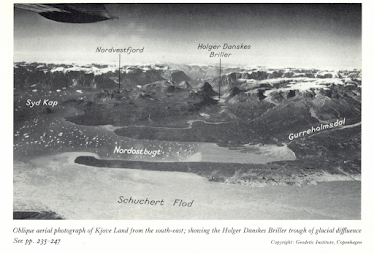
This is an extract from a geological map of the area, showing the bathymetry around the fjord exit.  Where the threshold occurs, the trough is about 10 km wide. The backslope is seen here to rise from a water depth of over 1000m to the two small islands over a distance of just 4 km.  The shallow sill stretches from the islands to the coast near Syd Kap  at a depth of c 300m.  But to the west of the islands the threshold is breached by a deeper channel in which the water is over 800m deep.  This channel swings round towards the SE between the islands of Ingmikertaje and the Bear Islands -- so this was clearly the main ice discharge route at some stage towards the end of each glacial episode. 

This is an Ernst Hofer image of the Bear Islands, looking NW from the southern tip of the archipelago.  Note the winding ridge of moraine, on the island called Sulugssut.  Is it linked to the Milne Land stage moraines in Kjove Land?  Some fieldwork is needed......


This is a good explanation from Wikipedia for what goes on in the deepest parts of closed troughs where overdeepening happens on a spectacular scale.

https://en.wikipedia.org/wiki/Overdeepening

"Analytic glacial erosion models suggest that ice flows passing through constrained spaces such as mountain passes produced enhanced erosion beneath thicker, faster ice flows, which deepens the channel below areas both upstream and downstream. The underlying physical phenomena is that erosion increases with the rate of ice discharge. Although this simplifies complex relationships among time-varying climates, ice sheet behaviors and bed characteristics, it is based on the general recognition that enhanced ice discharges typically increase the erosion rate. This is because the basal sliding rate and the erosion rate are interrelated and driven by the same variables: the ice thickness, the underlying bed slope, the overlying glacial slope and the basal temperature. As a result, the modelled fjords are deepest through the narrowest channels (i.e., regions with the highest surrounding highest topography). This corresponds with actual physical observations of fjords.[16]"

Where was the ice surface when the Nordvestfjord Glacier was reaching its exit and starting to spread laterally?  Let's be conservative and pretend that the snout surface was around 200m in the vicinity of Syd Kap.  Suddenly a glacier that was 1.4 km thick was forced to become a glacier approx 400m thick, flowing over the threshold.  The ice volume in the threshold area was thus 1 x 7 x 5 kms = 35 cubic km of ice being forced like toothpaste out of a tube, up a reverse slope 1000m high, and then away into the unrestricted terrain of Hall Bredning.

Who was it that said that glacier ice could not possibly flow uphill?

Monday 20 September 2021

Bluestone Museum -- new acquisition


The Curator, Trustees and Management Committee of the Bluestone Museum in Cilgwyn, Pembrokeshire, are delighted to announce a new acquisition which is now on display.  Occams Razor was purchased for an undisclosed sum, with the help of the National Lottery, the Science Museum and a single generous donor who wishes to remain anonymous.  The authenticity of the razor has been proved through DNA analysis of minute fragments of stubble stuck beneath the blade, which have been matched precisely with the chin of Mr Fred Occam himself.  So valuable is this item that the Museum has had to install bullet-proof glass and a full 24-hours surveillance system.

Waun Mawn 2021 -- the desperation dig (2)


The new recumbent monolith at Waun Mawn.  A fallen standing stone, or just a lump of glacially emplaced unspotted dolerite?  We shall see......


This is the second brief report on what is now visible to passing ramblers and lost circle hunters, following the conclusion of the 2021 digging season by MPP and his "Stones of Stonehenge" team.   The first report is here:

https://brian-mountainman.blogspot.com/2021/09/waun-mawn-2021-dig-is-done-1.html

To continue:

3. The Waun Mawn "lost circle"

This year, the team implied (in its application for consent) that only a small area would be excavated, with highly targetted small excavation pits opened up with a view to answering quite specific research questions.  On the map submitted only four small areas were identified for excavation trenches:


To me, this looks like around 50 sq m of excavations.  When I walked over the site yesterday, I was staggered to find that there were at least eight new excavations (some of them very large) and several "revisits" to previously excavated areas, where old turves have been lifted and then re-laid.  

There has been much activity on the western segment of the "circle circumference", with five digging locations with the following approx dimensions: 2m x 2m; 10m x 20m; 20m x 20m; 5m x 2m; and 5m x 5m.  In the fourth of these excavations, moving southwards or anticlockwise from the NW recumbent stone, a new boulder has been lifted and left exposed, presumably because the diggers have interpreted it as another recumbent or fallen monolith.  No doubt we will hear more about this in due course. Other smaller boulders are also now exposed at the surface, which means they have been removed from their original positions in the glacial till spread.

In the centre of the putative 100m diameter "lost circle" it was the intention to look for a post hole used with a rope or line for marking out the circle circumference, or else for an empty socket or recumbent "central pillar".  If any big stone had been found, it would have been left exposed -- but we await further information on what was discovered.  But the excavation here was not a small one -- it was a big and very messy one with dimensions c 8m x 8m.   

There was another big and messy excavation on the eastern edge of the imaginary circle circumference, with an area of c 10m x 10m. I imagine that this dig was done in association with the work of Clive Ruggles, looking for stones or sockets of significance for astronomical alignments.  A lot of stones were collected by the diggers and left behind in a pile under a gorse bush. 

Stones collected by the diggers.  Mostly locally derived volcanic ash, rhyolite and meta-mudstone.


The last of the excavations for this year was about 2m x 2m in extent, adjacent to the small broken recumbent stone in the NE quadrant.

So the total excavated area this year was around 807 sq m -- considerably greater than the previous digging season.   For comparison, this is what happened in 2018, when 700 sq m were excavated, including 160 sq m "accidentally dug" over and above the total originally notified to NRW:

https://brian-mountainman.blogspot.com/2018/10/waun-mawn-2018-dig-and-some-very.html

Let's assume that the vast expansion of the digging area in 2021, over and above what was in the original project plan, was done in close cooperation with the National Park and NRC.   If this was all done without authorisation, we have a problem.  Or rather, MPP has a problem.

So no big stone has been found at the "circle centre" and the only substantial stone unearthed is in the SW quadrant.  To me, that looks like a glacially emplaced boulder, but the diggers will no doubt have hunted beneath it to see if there are any dateable organic remains.  Watch this space.........

One further point regarding rock types -- I have again spent a fair amount of time looking at rock fragments and boulders, and have seen no trace of any spotted dolerites.  So I am as certain as anybody can be that nothing from Carn Goedog has been used here, and that any large stones set into the ground have been locally derived unspotted dolerites.  The basic and frequently occurring rock types are Abermawr shale, meta-mudstones and meta-shales altered by igneous activity, rhyolites, volcanic ashes and unspotted dolerite of several types. There may be some sandstone fragments too.   I have not seen anything that looks as if it might have come from Rhosyfelin.

So how do we explain this sixteen-fold increase in the size of the 2021 digging area, as compared with what was planned?  Well, it looks as if nothing of much interest was found -- if that assumption is wrong, I will correct it when I get more feedback from MPP's brewery talk on 14 September.  We already know about interpretative inflation -- I think what we have here is a classic case of "excavation exasperation" in which the diggers, having initially not found what they were looking for, just kept on digging till they all ran out of steam.  They were so desperate to find something -- anything -- that would provide validation or confirmation for the "lost circle" hypothesis that they forgot all about their original research design and went for broke.  That's the way I see it.

For the time being, or until some evidence appears from somewhere, let's just refer to this one as the "desperation dig".


Sunday 19 September 2021

Waun Mawn 2021 -- the dig is done (1)


Little and Large -- the two most prominent stones at the "entrance" to the Gernos Fach embanked circle.

They had good weather on the excavations this year -- and by the look of it got quite a bit done, in spite of the rumoured shortage of diggers.  I never managed to take a walk on the moor while the dig was in progress,  since I have been getting post-vaccine dizzy spells.  But today I felt better, and ambled up there to take a look.

I gather that in the Project Design plan, three areas were due to be excavated:

1. Possible embanked enclosure  c 40m north of Waun Mawn stone circle.  
2.  Gernos Fach embanked circle, well known to me and several others but claimed to have been "discovered" by a member of the MPP team earlier this year.
3.  The Waun Mawn "lost circle" circumference and centre, complementing digs in 2017 and 2018.

This is what is observable following the departure of the excavators:

1. Possible embanked enclosure
I have drawn attention to these recumbent stones in a number of posts on this blog, although the MPP team appears not to have noticed them previously.  As admitted by the excavating team, "This may well be an entirely natural feature but its proximity to the stone circle makes it a priority for investigation in 2021."  They speculate that there may be an "embankment with slabs", and there is indeed a very slight rise in the ground surface -- but the surface is full of undulations, and I see nothing unusual or potentially man-made about it.  There are three stones exposed -- two rather irregular unspotted dolerite boulders and one sharp-edged slab.  They are not aligned or on the circumference of any arc or circle.  What we see may be just the tips of much larger boulders or rock outcrops. The diggers planned to examine the contexts of each stone, and this is what they have done, with three excavations -- two quite tightly around the two eastern stones and a third excavation about 12m x 2m in extent, from the westernmost stone and running towards the supposed circumference of the "lost circle."  The total area excavated is about 56 sq m.  My assumption here is that they found nothing of any interest.

The largest of the three unspotted dolerite recumbent boulders.  This may simply be the tip of a much larger erratic block, or maybe even a rock outcrop.  

2.  Gernos Fach embanked circle.
There have been three substantial excavations on this site, as planned.  The circular embankment or ridge is very visible, and the diggers have stripped off the turf in one patch 3m x 3m at the centre, one patch c 10m x 8m on the northern segment, and a much more extensive area about 18m x 8m on the western edge, around the assumed "entrance passage".  Several stones have been exposed that were not previously visible, and it remains to be seen whether they were previously standing stones which have now fallen over.  Three new stones are exposed on the north side of the "entrance passage."    The big leaning stone on the north edge of the "entrance passage" is shown to be very large indeed, and I suspect that it may be as large as the other standing stones which are already well known on Waun Mawn.  It could be between 3m and 4m long and up to 1m wide.  It's a rough piece of local unspotted dolerite with clear signs of glacial abrasion and a thick weathering crust.  Most of the rock fragments here are of local dolerite, with one smaller fragments of quartz, also locally derived.  I didn't see any rhyolite, meta-mudstone or ash -- but I would not be surprised if some should be found in the excavations. I saw no traces of any spotted dolerite.  The total area excavated is about 233 sq m.

There are rumours of a "paved area" or of slabs set flat on the ground in the area of the circle entrance -- but no doubt this will figure in future announcements of the excavation results.  No doubt there will be organic remains from here, and I expect the C14 dates, when they arrive, to show that this is a Bronze Age feature.  And of course it will have nothing whatsoever to do with Stonehenge...........

There are scores of other features in the Waun Mawn - Tafarn y Bwlch - Banc Llwydlos area which are equally deserving of investigation, and I hope the MPP team will turn their attentions to some of those in future years.

The cluster of stones around the entrance to the embanked circle.  The ground surface has been lowered, exposing more of the "leaning monolith" that once must have been a very impressive standing stone.

Small quartz fragments found during the dig.  There are a number of very substantial quartz outcrops in the vicinity.

I have no concerns about these two excavation sites in that the digs proceeded as planned.  However, the digs associated with the Waun Mawn "lost circle" are another matter entirely, and a vast area has been excavated this year -- which is wildly at odds with what was planned and with the "excavation map" submitted to the authorities.  I'll devote another blog post to the increasingly desperate "lost circle" evidence hunt........