THE BOOK
Some of the ideas discussed in this blog are published in my new book called "The Stonehenge Bluestones" -- available by post and through good bookshops everywhere. Bad bookshops might not have it....
To order, click
HERE

Monday 28 February 2022

Maen Dylan -- another giant erratic


Glacial erratic boulder
Trwyn Maen Dylan is host to (possibly) the largest erratic boulder that I have ever encountered on the shore of North Wales. Comprising dark-grey mudstone without any obvious features or cleavage, this monster required the serious attention of both my OSSP assistants. This stretch of coast is well-known for its abundant glacial till and glacio-fluvial deposits, and is well studied as part of the reconstruction of the later stages of the Devensian glacial period. (Photo: Jonathan Williams)

Grid ref:  SH 425 523, near Aberdesach, Gwynedd -- N flank of Llyn Peninsula and SW of Caernarfon.

It's intriguing that this massive erratic is made of mudstone, rather than an igneous rock, which is generally assumed to be more "survivable" in glacial transport. It is presumably therefore much more difficult to work out where its possible provenance might be.

It's been famous for quite a long time, and indeed it is mentioned in one of the tales of the Mabinogion.


Friday 25 February 2022

The Ramsey Sound Giant Erratic


The giant erratic rests left of centre, at the top of the rocky slope.  Most people walk straight past it without seeing it, since it lies a little way off the coastal footpath.

I was talking to somebody the other day about Ramsey Sound, and was reminded of the presence there of one of the most spectacular giant erratics in western Britain, right up on the clifftop at an altitude of c 25 m.  The location is SM 715235, and a little to the north of the old copper mine shaft shown on the OS maps.  On the satellite images you can spot the erratic because of the substantial shadow that it casts.

I measured the erratic many years ago, as approx 4.2m x 2.4m x 2m, which would give it a weight of around 60 tonnes.  That's a big erratic.........

Where has it come from?  Most likely Ramsey Island, but I need to check that out with the geologists.


Thursday 24 February 2022

The Coed y Pwll till sheet

The remains of a massive boulder embedded in the Irish Sea till sheet at Coed y Pwll.  A local farmer with a JCB has done his best to smash it up....... (Photo courtesy Nick McIlvenna)

Enough of the Chilterns and the Cheviots.  Things are even more interesting close to home.  Today Nick McIlvenna invited me over to his place to take a look at his marl pits.  Gosh - I have been here for 46 years and have never seen them before, although I have heard of them now and then from those who know what lurks in the depths of the woodland.

Anyway, Nick's land lies in a broad open area in the Nevern - Clydach Valley, about 4 kms to the SE of Newport and the coast.  To the west is the Clydach River, with Carningli beyond.  To the east is Pentre Ifan Wood. To the north is the great loop of the River Nevern, diverted northwards by glacial and glaciofluvial accumulations during the last glacial episode, namely the Late Devensian, around 24,000 years ago.  To the south is Cilgwyn, with an extremely complex association of glacial sediments and rock outcrops -- surface till, mounds of sand and gravel, hummocky morainic mounds and outcrops of rhyolite, dolerite and assorted volcanics.

 On the geological map we see an extensive sheet of till around Coed y Pwll, but this is very different from the till in the Cilgwyn area, which is best described as thin meltout till or flowtill mixed with patches of slope breccia and localised patches of meltwater deposits.  This is genuine Irish Sea till, still exposed at the surface because there are no slopes to generate freeze-thaw breccia or colluvium that might have covered it.  So on the surface there is occasional waterlogging, and exposures of sticky stony clay till.  It's exposed in the sides of a recently dug pond, as heavy clay-rich lodgement till with clasts of all shapes and sizes, mostly of local dolerite, rhyolite and volcanic ash but with many small foreign erratics. There is one massive boulder which has recently been uncovered by Nick -- it's big enough to have been the capstone of a cromlech, and the rock type reminds me of some of the rocks exposed in craggy outcrops in Tycanol Wood.   I did not see any sea shell fragments or lignite, but I would not be surprised to find them if we could just see a completely clean fresh face.  Nick tells me (from borehole evidence) that in places the till sheet is around 20m thick, with a thin layer (about 3m) of sand and then gravelly material beneath it which rests on the igneous bedrock.

To the south the till sheet is overlain by glaciofluvial sands and gravels, and towards Fachongle Isaf the junction between the waterlogged clay surface and the drier sandy surface is quite striking.  There are several hillocks of quite clean sand.

The fresh till is coloured light grey or bluish-grey, but at the surface the introduction of organic matter and pedological processes have given it a darker brownish hue, and there has been a lot of gleying here as well, giving a range of other colours from foxy red to orange to blue to white. On the coast (as at Abermawr and Mwnt) the Irish Sea till is calcareous and is composed mostly of dredged-up sea floor sediments -- but here it may be decalcified or weathered.

There is a very similar till sheet exposed in fields to the north of the A487 main road, to the east of the Temple Bar crossroads.  Here again it is very sticky underfoot, and there is much surface waterlogging.

George Own of Henllys described this till in great detail in one of the earliest "geological" pamphlets, in 1599.  I referred to it in this publication in the Journal of Glaciology, in 1964:

https://www.cambridge.org/core/journals/journal-of-glaciology/article/early-discoverers-xxi-a-description-and-explanation-of-glacial-till-in-1603-george-owen-15521613/8041F69CFA435A74F3BBE14F837C906C

https://www.researchgate.net/publication/252419230_A_description_and_explanation_of_glacial_till_in_1603_George_Owen_1552-1613

So this was the clay marl on which George Owen was so keen, back around 1600.  At one time, the land around Coed y Pwll was part of Owen's Henllys estate.   The marl was valued because it was calcareous and because it could be used to counteract the natural acidity of local soils --but if it was dug out, carted and spread onto rich and friable soil it must have been a nightmare to cultivate, and I suspect it did more harm than good........

Anyway, Nick has about 2 acres of clay pits in his woods, and they are magnificent. There are others within a kilometre or so, on land belonging to other farms.  I had assumed in advance that they were circular waterlogged hollows, but not a bit of it -- they are elongated sloping cuttings with steep sides, and separated by ridges.  They are between 5m and 8 m deep.  They are remarkably dry, even in the depths of winter, because all of the pits or trenches have sloping floors, some with gullies cut into them to facilitate good drainage.  There is one particularly deep trench with near-vertical sides close to Nick's house which is not a natural stream cutting -- and it must have been excavated to drain away the water from other clay diggings a couple of hundred metres to the south.  So the drainage routes run broadly N or NNW, down towards the Dolbont stream.  In one or two places there are signs of gently sloping "ramps" running from the outer ground surface down to the marl digging face -- these much have been used by horses and carts, by far the most efficient haulage method. There was a lot of engineering here -- pits, drainage channels and infrastructure.  No buildings, as far as we know.   I hope Nick will make a map of the marl cuttings, since they are impossible to see from above because of the mature tree cover. 

We can assume that most of the excavated clay marl was sold to local farmers for spreading on the land, but I am intrigued by the idea that some of it might have gone to the medieval pottery kilns in Newport.  It could well be that these pits were open in the Middle Ages, and we can assume they were in operation around 1600, but we do not know when the last digging occurred.  Intriguingly, the clay pits are not shown on any of the OS maps.......


The restored medieval pottery kiln beneath Newport Memorial Hall


Artists reconstruction of two kilns as they might have appeared in the Middle Ages.  Where did the clay come from?

All in all, the evidence from this spread of lodgement till is of no relevance to the debate about the bluestones, but it tells us a lot more about the events of the last glacial episode in North Pembrokeshire.  As I have said before on many occasions, I think the incoming ice of the Irish Sea Glacier overtopped Carnedd Meibion Owen and possibly Carningli too.  This means that the ice which flowed across this expanse of lodgement till must have been at least 300m thick.

Wednesday 23 February 2022

Matt gets it right...


Isn't it funny how the best cartoonists have a knack of homing in on the essentially ludicrous things shoved into the media (and written up in learned articles) by so-called experts?

There's this thing called logic......


 When we are involved in a scientific dispute the first thing to do is to recognise that it exists.  MPP, Ixer and Bevins seem to have a problem with that, since they have never admitted that any of their ideas are disputed or that their evidence is challenged, and have systematically, as a matter of policy, refused to cite any inconvenient peer-reviewed articles that have a bearing on the story that they have cobbled together.  That is a matter of regret as well as being an obvious sign of weakness.

On this blog we have discussed quite often things like the scientific method, Occam'r Razor, Hitchens's Razor and the ruling hypotheses.

Here are some more things which we should all bear in mind as the debate rolls on......

Tuesday 22 February 2022

The Stonehenge bluestone dump -- a reconstruction


 I'm sometimes asked what the bluestone assemblage at Stonehenge might have looked like when the stones were discovered and used by the builders of the ruinous old monument.  Well, I think it might have looked something like this -- a pile of spotted dolerite boulders in the landscape near Glan yr Afon on the north flank of Mynydd Preseli.

These boulders have not been here for all that long -- maybe 24,000 years or so, since the end of the last glacial episode.  Any boulders left behind by the ice in the Stonehenge landscape would have been exposed to the atmosphere for very much longer -- maybe 450,000 years -- or if my "reassignment of glaciations" is valid, around 650,000 years.  That period of time must have spanned both interglacials and long periods of periglacial climate as the glaciers expanded and contracted further north.  For long periods of time, surface boulders might well have been overshadowed by vegetation, and for many thousands of years they will have been intermittently covered by snowfields.  But there will nionetheless have been many thousands of years of cosmic bombardment.

The only way we are going to approach the truth on this matter is by getting cosmogenic dating on the surfaces of some of the Stonehenge bluestones. If they were quarried, as the archaeologists like to think, there will be surface exposure ages of c 5,500 years or less.  If they are genuine glacial erratics, the ages will be so great that they will be almost off the scale.......... 

One day, when EH starts to cooperate in some proper science, truth will out........

I would love to see a proper dating programme, with samples taken from the Stonehenge bluestone boulders, from Pembrokeshire tors, from Pembrokeshire erratic boulders, and from the so-called quarry faces at Rhosyfelin and Carn Goedog..........


Pic: courtesy Simon Banton


Amroth -- more till exposed


The recent storms have caused some more cuttings in the submerged forest exposures, revealing once again the layer of stictly clay till underneath.  These photos have kindly been posted on Facebook by Gary Davies, and they are the best ones I have seen yet of a fresh till at the eastern extremity of the S Pembs coast.


We are quite close to the cliffline here, and perhaps inevitably the sticky clay till (I think we can refer to it as Irish Sea Till) has incorporated a lot of blocky and angular material from the accumulated slope breccia beneath the cliffs.   With the onset of glaciation, sea level falls, and slope breccia accumulates, over many thousands of years, to be overridden at last by glacier ice....... 

Southern England: where is the glacial limit?

After much thought, the blue line on this map shows where the outer limit of glaciation in Southern England might actually be located.  Maybe this is a "composite line" showing the limits of different ice lobes of different ages, but this may also be the "Stage 16 glaciation" otherwise referred to as the Happisburgh or Cromerian glaciation, dated to c 650,000 years ago. The white line represents the outer limit of the Anglian glaciation, dated to MIS-12, around 450,000 years ago. 

Numbers identify key research areas: 1 Exmoor and the SW uplands (local ice caps and snowfields). 2 Somerset Levels.  3 Mendip.  4 Salisbury Plain.  5 North Wessex Downs.  6 Cotswold Hills.  7 Plateau drift remnants near Oxford.  8 Chilterns.  9 Chalky Till spread.

This is a big post, and a very important one.  Bear with me.

Quote:  "The Anglian Glaciation (c. 0.43 Ma; MIS 12) marks the biggest Quaternary expansion of the BIS and had a marked effect on the landscape of Britain. It radically altered drainage and relief, and initiated the formation of the Straits of Dover which led Britain to be isolated from mainland Europe during various high sea-level stands during the Middle and Late Pleistocene. The chronology of Middle Pleistocene expansions of the BIS is still contentious, with conflicts existing between different types of evidence, and in some cases, different interpretations of the same evidence."

LEE, J R, ROSE, J, HAMBLIN, R J, MOORLOCK, B S, RIDING, J B, PHILLIPS, E, BARENDREGT, R W, AND CANDY, I. 2011. The Glacial History of the British Isles during the Early and Middle Pleistocene: Implications for the long-term development of the British Ice Sheet. 59-74 in Quaternary Glaciations–Extent and Chronology, A Closer look. Developments in Quaternary Science. EHLERS, J, GIBBARD, P L, AND HUGHES, P D (editors). 15. (Amsterdam: Elsevier.)


=======================

This is an interesting summary of the problems associated with very old glacial episodes, by Rose et al (2010):

Attempts to understand the glacial history of Britain have generated much work and much debate (see Clark et al., 2004 and Rose, 2009 for outlines of the current debates), and one of the issues of contention is the status of glacial events before MIS 12 (the Anglian Glaciation of the British Quaternary). Conventional views, as expressed in Bowen et al. (1999) and by Gibbard in Clark et al. (2004), find no evidence of substance for glaciation prior to MIS 12, whereas Whiteman and Rose (1992), Hamblin et al., (2000, 2005), Lee et al., (2004), Rose in Clark et al. (2004) and Rose (2009) identify much evidence for glaciations prior to MIS 12, proposing glaciations in Wales, a glaciation in the upper part of the present Thames catchment and lowland glaciation in eastern England. This issue is important as glaciation is perhaps the most effective indicator of how the climate of the British Isles responded to the climate forcing of the Early and early Middle Pleistocene, and in particular how Earth surface systems responded to obliquity-driven climate change and the Mid-Bruhnes Transition (Clark et al., 2006; Rose, 2010).

The critical problems fuelling this debate are the quality of the evidence used to propose glaciation, and the reliability of the evidence used to date the proposals. For instance, the Happisburgh Glaciation, which is well represented by unequivocal glacial deposits (the Happisburgh and Corton Tills) (Lee et al., 2004; Hamblin et al., 2005; Rose, 2009), is ascribed to MIS 16 on the basis of stratigraphic sequences and relationships with pre-MIS 12 Bytham river deposits, but this age is challenged by First Appearance Datum / Last Appearance Datum (FAD/LAD) bio- stratigraphy and AAR results, which suggest that such an early age is not possible (Preece et al., 2009). Likewise, a number of glaciations have been proposed for western Britain on the basis of glacially-sourced material (clasts provenanced to the Welsh Mountains and Borderlands) (Hey and Brenchley, 1977; Whiteman, 1990), and glacially fractured sand grains (Hey et al., 1971, Hey, 1976) in the Early and early Middle Pleistocene deposits of the River Thames. In this case, unlike the case for the Happisburgh Glaciation, the early age of the evidence is not in question, rather the issue is whether the evidence is good enough to justify the case for glaciation. It is possible, for instance, that the clasts could have been derived from the head-waters of the ancestral Thames catchment by frost shattering and transported from these regions by fluvial and ice-floe processes, and the origin of surface textures on sand grains remains an issue of debate (Whalley, 1996). Hey and Brenchley (1977, p. 224) noted that ‘no glacial striae have yet been recognised on any pebbles of boulders of the Kesgrave gravels ...’.

===================

So here is my take on the situation:

For something like 50 years it has been accepted in the specialist literature that the supposed "Anglian" ice limit in the Midlands is a proxy for the greatest extent of glaciation in the British Isles.  I myself have slipped into that style of thinking on many occasions.   But how logical is it to assume that glacier ice has never extended beyond that widely-quoted line drawn on a map?  What about the evidence on the ground?

Well, for a start, the line (which is itself a matter involving some disagreement) purports to show the southernmost limit of coherent and easily reconizeable glacial deposits including till. It has always been accepted that there might be destroyed or redistributed glacial deposits further south, and the literature is full of instances where glacial till appears to be incorporated into other deposits including slope deposits and fluvial gravels.  In the upper and lower Thames Valleys the vast quantities of terrace gravels laid down during a long history of river valley evolution have masked or sealed older deposits which are only very rarely exposed during gravel pit operations -- and which are often then immediately flooded. The Anglian ice limit portrayed in the Celtic Sea has been submerged and more of less forgotten about as the LGM ice limit has been pushed further and further south, right out to the shelf edge, by the work of James Scourse and others. And if the Anglian Glaciation was more extensive and intensive than the Devensian Glaciation, did the ice of the Irish Sea Glacier extend all the way to a calving ice front when deep water was encountered? It is known from East Anglia that there are glacial deposits in the sediment sequence that are older than the Anglian glaciation, and these are referred to as the "Cromerian" sequence (MIS-22-13) or the Happisburgh Glaciation.  Others refer to oxygen isotope stage 16  as a distinct glacial episode.

There are some difficulties.  To quote Lee et al (2011):  "Far- travelled erratics from north Wales, including frequently outsized and sub-angular clasts of acid porphyry, tuff and banded rhyolite (Hey and Brenchley, 1977; McGregor and Green, 1978), and glacially-abraded sandgrains (Hey, 1980), have been found throughout both the Sudbury and Colchester formations (Whiteman and Rose, 1992), and recently, a glacially striated oversized block of rhyolitic tuff has been discovered in situ in the Colchester Formation (Rose et al et al. 2010)."   "The increased influx of north Welsh erratic lithologies into the Ardleigh Terrace aggradation has been attributed to a glaciation reaching the Cotswold Hills after the truncation of the Thames catchment........"

The glacial history of the Midlands is clearly not quite as simple as we would like it to be, and the striated erratic in Essex which seems to have come from North Wales makes life even more confusing (Rose et al, 2010). See the post on this:  https://brian-mountainman.blogspot.com/2022/02/a-very-erratic-essex-erratic.html

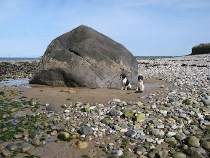
Then we come to inconvenient erratics.  There are a lot of them about -- the best known being the giant erratics and smaller erratic boulders on the coasts of Devon and Cornwall.  Some (for example around Ilfracombe and Saunton) are more than 80m above sea level; and some (for example at Shebbear and Westonzoyland) are many km inland.  The erratic boulders at Boles Barrow and Stonehenge should be included in this category; some have been shaped, but most of them are in their natural state -- heavily abraded and weathered, like an assemblage of erratic boulders found at the edge of any typical glacier.  (I reject the idea that these do not count, just because some say they were quarried and transported by human beings, since that hypothesis has never been supported by solid field evidence.)  Conventionally, all these "strange boulders" are simply ignored by geomorphologists -- and that, quite frankly, is not good enough.  Somehow, they were transported from their places of origin and dumped at their current locations.  The only transporting medium that makes any sense is glacier ice -- but the prevailing theory is that the areas concerned were never glaciated.  So the theory must be faulty.

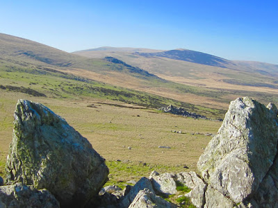
Two recent discoveries have strengthened the thesis that the chalklands of Wiltshire have been -- at one time -- affected by glacier ice.  First, the discovery of a "giant dolerite erratic" on the rocky foreshore of Limeslade Bay on the Gower Peninsula demonstrated -- for those who might have been sceptical about it -- that the Irish Sea Glacier moved eastwards up the Bristol Channel and that it was capable of transporting far-travelled and massive lumps of rock towards Salisbury Plain.  That may well have happened on at least three occasions. Second, the discovery of abundant fragments of grus or rotten granite near West Kennet, in an archaeological dig, proves that at one time there was a large granite erratic on the site.  The fact that its provenance is suggested as Cheviot, 450 km away to the north,  suggest glacial transport all the way from north to south.  So here we have evidence of ice incursions onto Salisbury Plain from the west and onto the chalk downs from the north.

There are smaller erratics too, all over the Stonehenge landscape on Salisbury Plain -- and it would be irresponsible to ignore them.  In the debitage, in small pebbles and cobbles, in the collection of packing stones, mauls and hammer stones, and in flakes and fragments in the debitage and in the "Stonehenge Layer" around 30 different provenances are represented -- the great majority of them having copme from the west.  Many of the fragments are not represented in the "bluestone monolith" collection, so they have not come from the destruction of standing stones or the manufacture of axes and other implements.  The most parsimonious explanation of them is that they are glacial erratics associated with till or morainic deposits that are very old indeed and which have largely been removed through weathering and slope processes.   Since thousands of these "foreign" fragments have turned up during the course of excavations covering just a minute fraction of the land surface, it is inevitable that there are many thousands more awaiting discovery.

Next, the strange deposits conventionally classified as Northern Drift / Plateau Drift, or clay-with-flints.  Those simple labels cover a multitude of sins!  As we have seen on previous posts about the Mendips, the Cotswolds and the Chilterns, the deposits are quite frequent, patchy and sometimes over 10m thick.  They also occur on Salisbury Plain and on the North Wessex Downs.  Many authors have speculated that they are made up partly of very ancient glacial deposits, partly of river gravels, and partly of weathering products from a rock cover long since removed by erosion.  They occur on chalk, limestone, and other hilly areas where sedimentary rocks outcrop, across many parts of SE England.  So caution is needed in their interpretation, and a great deal more research.......


Clay-with-flints near Andover.  What exactly were the formation processes?


The Chilterns during the Ice Age -- a somewhat dodgy artists impression, with nice cosy trees and bushes in a tundra landscape...... 

In conclusion, I suggest that at the peak of some early glaciation, which might have pre-dated the Anglian glaciation dated to c 450,000 yrs BP, there was an ice front stretching across southern England from the Dorset coast towards Salisbury and thence to the south of the North Wessex Downs and the Chilterns, looping around the northern edge of Greater London, and then extending to the North Sea coast near Chelmsford.  This will be deemed by many to be an outrageous suggestion, since it moves the outermost glacial limit southwards by about 80 km in the Midlands and eastwards by around 40 kms in the country to the east of the Bristol Channel.  As stated by Jim Rose and others, the question is now as follows:  is  the evidence good enough to justify the case for glaciation?  

I don't expect the suggestion to be greeted with acclamation by geomorphologists, but if they choose not to take it seriously they do need to think very carefully about some of the lines of evidence presented above.  And I am not a lone voice here; many others have suggested that glacier ice reached Salisbury Plain at some stage, and no less an authority than Richard West suggested many years ago that glacier ice covered the Chilterns and filled much of the Upper Thames basin in the area between the North Cotswolds and the Goring Gap.  Let the debate begin!

My parting shot.  The "southernmost glacial limit" line as I now propose it is spookily similar to that which popped out of one of the "extreme" glaciation models created by Henry Patton, Alun Hubbard and others when they were trying to recreate the conditions needed for the Devensian Glaciation.  That cannot just be a coincidence.....


PS.  There's more.....

I started this post with the idea in my heard that the "Anglian" ice edge needed to be redefined and pushed southwards and eastwards.  Now I'm not so sure.  Is the Anglian (MIS-12) ice limit, as it is widely accepted, more or less correct, and are we now seeking to define the edge of a much earlier glaciation for which we only have scattered and diffuse evidence?  

If so, which glaciation?  Is this the Happisburgh Glaciation referred to by Rose et al (2010)?  According to Lee et al (2004) this might have been equivalent to the Cromer Glaciation of other UK researchers and the Don Glaciation of eastern Europe, in MIS-16.  This was around 650,000 years ago.

Dating the earliest lowland glaciation of eastern England: A pre-MIS 12 early Middle Pleistocene Happisburgh glaciation (2004)
Quaternary Science Reviews 23(14):1551-1566
Jonathan R. Lee, James Rose, Richard J.O Hamblin, Brian S.P Moorlock
DOI:
10.1016/j.quascirev.2004.02.002

Interestingly enough, Campbell (1998), in his Synthesis of the GCR volume on the Quaternary of South-West England (map on p 23) suggested that the giant erratics and other "inconvenient" features in SW England might be relics of what he called "the Stage 16 Glaciation".  I quite like this assignment, since it deals with some awkward evidence in the sedimentary record for Somerset which suggests that at least some glacial traces there are pre-Anglian in age.

Work in progress........


More on the Altar Stone

 I'm in touch with a lot of people off the record, and it's good to see that there are several correspondents who are working on "the Altar Stone problem."  As we know, Bevins and Ixer have suggested that the Altar Stone has nothing to do with the Cosheston Sandstone of Pembrokeshire, but is most likely derived from the ORS Senni Beds which outcrop in the Tywi Valley and in parts of mid Wales on the north flank of the Brecon Beacons.  They suggest that the degree of metamorphic alteration of the Altar Stone -- or rather, the sample that they have analysed -- suggests that the source outcrop might be in the area around Abergavenny.   Their problem is that there are outcrops over a very wide area, and they have neither the time nor the manpower to check out the territory.

This is where Mavis of Morriston comes in.  She has been visiting lots of sites, and thinks that she might now have the actual source of the Altar Stone nailed.  We look forward to seeing the results of the investigations published in due course.


The edge of the Altar Stone as it was seen in 1958


Above images:  is this the sister of the Altar Stone?


Monday 21 February 2022

A very erratic Essex erratic


The "Welsh" erratic found in ancient River Thames gravels near Colchester 
on the North Sea coast.

A striated, far travelled clast of rhyolitic tuff from Thames river deposits at Ardleigh, Essex, England: evidence for early Middle Pleistocene glaciation in the Thames catchment
J. Rose,  J.N. Carney, B.N. Silva & S.J. Booth (2010)
Netherlands Journal of Geosciences — Geologie en Mijnbouw 89 (2 |),  pp 137 - 146

https://www.cambridge.org/core/journals/netherlands-journal-of-geosciences/article/striated-far-travelled-clast-of-rhyolitic-tuff-from-thames-river-deposits-at-ardleigh-essex-england-evidence-for-early-middle-pleistocene-glaciation-in-the-thames-catchment/70E04344BEEC550AA135F38130748AFD

Abstract

This paper reports the discovery of an in-situ striated, far-travelled, oversized clast in the Ardleigh Gravels of the Kesgrave Sands and Gravels of the River Thames at Ardleigh, east of Colchester in Essex, eastern England. The morphology, petrography and geochemistry of the clast, and the sedimentology of the host deposit are described. The striations are interpreted, on the basis of their sub-parallelism and the shape and sub- roundedness of the clast, as glacial and the clast is provenanced to Ordovician rocks of the Llyn and Snowdonia regions of North Wales. On the basis of clast frequency within the Colchester Formation gravels of the Kesgrave Sands and Gravels it is inferred that glaciers reached the Cotswold region of the Thames catchment. Floe-ice transport during spring flood is invoked for movement from the glaciated region to eastern England. The paper discusses the possible age of the glaciation and recognises that it is difficult to be more precise than a cold stage in the early Middle Pleistocene (MIS 18, 16 or 14). Attention is drawn to the possibility of glaciation associated with a diamicton in the region of the Cotswold Hills known as the Bruern Till, but stresses the need for new work on this deposit.

This is quite a puzzle.  the authors have had detailed analyses of the erratic done, and they seem pretty sure of the suggested provenance, although there are a few other possibilities -- mostly also in Wales.  What was a striated boulder like this doing in river gravels?  The only thing they can think of is that the boulder was carried from North Wales and incorporated into ancient glacial deposits (now destroyed) in the Cotswolds, in the headwaters of the early Thames river.  After the passage of an unknown amount of time, the glacial deposits were eroded away at a time of very cold climate, and the boulder was picked up (maybe many times) from the bed of the river and incorporated into seasonal ice -- then swept along at the time of the spring flood, then dropped, and then picked up again later, and carried, and dropped, and so on and so on, maybe thousands of times before reaching its final destination.  That's a very clunky explanation, as appreciated by the authors themselves -- but nobody, for the time being, can come up with anything better........

My own problem with the "multi-trip ice rafting explanation" is that in a turbulent shallow water environment such as that proposed, dominated by coarse river gravels, there must have been a huge amount of abrasion on all the materials being gradually moved downstream -- and in that sort of environment I do not see how the glacial striations could have survived.


Sunday 20 February 2022

Goring Gap and the Chiltern channels


Ah -- what a peaceful scene!  The Goring Gap, conventionally portrayed as being well to the south of the "Pleistocene ice limit" of southern England, but also conventionally described as having been cut initially by glacial meltwater spilling southwards from an ice-dammed lakes on the northern flank of the Chiltern Hills and the North Wessex Downs.  Some say the ice edge was far away, and others say it was close by, since there is not much evidence for an extensive "Lake Oxford" in the literature.  

Anyway, I was intrigued by this dilemma and came across an interesting MA thesis written by Cherry Antoinette Goatman in 1961.  It's a good thesis, in which she examines carefully the assorted arguments for the formation of the Goring Gap and the wind gaps or channels on the crest of the Chilterns.  I append some extracts from her thesis, but suffice to say that having read it and pondered on the evidence she brings forward, it seems pretty obvious that the Chilterns have been glaciated, and that meltwater (subglacial?  that's more difficult to sort out....) was responsible for the spectacular valleys of which the Goring Gap is the best known.


SOME ASPECTS OF THE GEOMORPHOLOGY OF THREE CHILTERN WIND-GAPS

by  CHERRY ANTOINETTE GOATMAN

UNIVERSITY OF LONDON M. A. GEOGRAPHY I96I


ABSTRACT
Although there have been many publications dealing with the general geomorphology of the Central Chilterns and Vale of Aylesbury, none has yet dealt satisfactorily with the problems of the age, origin and development of the wind-gaps and their associated superficial deposits. Three gaps, the Wendover, Tring and Dagnall, have been selected for detailed study. The morphological features have been mapped on the 6 inch scale, the soils and gravels examined, and the pattern of soil series dis­ tribution related to the landforms. The various features of the gaps have then been compared, and suggestions made as to the possible evolution of the gaps.

The principal hypotheses so far put forward postulate that the gaps were initiated: 1) by pre-glacial rivers; 2) as glacial overflow channels ; 3) by marine erosion in Pliocene times; 4) by pre-glacial rivers and modified by glacial melt-water. The last of these, with ampli­fications, seems most in accord with the field evidence accumulated in the course of the present study. Thus a hypothesis of major south-east flowing captured Mid- Tertiary consequents is submitted for the origin of the wind-gaps at Wendover and Tring. Subsequently each gap was affected by the Calabrian marine invasion and later modified both by glacial and periglacial processes.

Deposits
.............. more recent deposits on the dip-slope present a complex variety and have been variously interpreted (Fig, 4 ). Sand and shingle of early Pleistocene age (Calabrian) has been located by Wooldridge (1927) at an elevation of some 600-650 feet. Brickearth (Hull and Whitaker I86I), Pebble Gravel (Jukes-Browne and White I908), Clay-with-Flints (as delimited by the Geological Survey) and Pebbly Clay and Sand (Sherlock 1947) have all been grouped together by Loveday (1958) under the general heading of Plateau Drift, which has a total thickness or some 30-40 feet. This drift is evidently a product or one or more or the early Pleistocene glaciations when the Chilterns possibly supported a local ice cap, according to Wooldridge (1938),and were certainly subject to the effects of periglacial climates. Loveday's terrace deposits (the Plateau Gravel of Jukes-Browne and White, I908, and the Glacial Gravel of the Geological Survey) generally lie below 500 feet and are younger than the Plateau Drift.

They have recently been thoroughly worked over in con­nection with the evolution of the Thames. Patches of Glacial Gravel are also mapped by the Geological Survey on the northern margins of the Vale of Aylesbury. The Valley Gravels and Gravels opposite Chalk Gaps are thought to be head deposits resulting from solifluction during more recent Pleistocene glaciations and are intermingled with more recent hill-wash and alluvium.

The wind gaps and channels
p 32    There are erratics at 462 feet on Southend Hill (Grid Ref. 920 165) in the Vale of Aylesbury......

Sherlock citations: "It is highly probable that the Chiltern Hills held up an ice-sheet..... It is likely that, on the retreat of the ice, channels would be cut in the chalk scarp by the water produced by the melting ice and snow".    In 1935, he referred to these features again (Page 53) as "cut out of the chalk by the melt-waters from the plateau".

Hawkins, in 1923, went even further along these lines. He suggested that the outlines of the both Goring Gap had been shaped by a tongue of ice and melt-water from a glacial lake but produced no very convincing evidence for this. He also mapped three stages in the retreat of this assumed ice mass (Fig. 9 ). He felt there were sufficient grounds for mapping the ice, at its farthest extent, as penetrating to the watershed of the Wendover Gap and to Berkhamsted in the Tring Gap. The second stage was thought
almost to have reached the Wendover watershed and as far as Horthchurch in the Tring Gap. The third and final stage was limited to areas below the 300 foot contour.

THE GLACIAL MELT-WATER THEORY
This hypothesis attracted many of the earlier workers in the area and, in spite of the fact that some of the later workers felt they had conclusively dis­proved it, similar ideas still reappear in different guises in some of the general literature. The theory in essence requires the entrance of a tongue of ice into the Vale of Aylesbury from the north-east, the impound­ing of a lake between the receding ice front and the Chiltern escarpment, and the overflow of its waters through spillways breaching the Chalk cuesta.

--------------------------------------

Like all theses, this one is a product of its time -- with mentions (which one would never get nowadays) of cycles of erosion and marine erosion at the time of a "Calabrian Sea".  But all that was very popular in London University in 1961, so she had to go with the flow......  However, at Rothamsted and at the Little Heath SSSI there are traces of Red Crag shoreline deposits, probably dating to Late Pliocene / Early Pleistocene times, prior to local crustal uplift.

Interestingly enough, in the 1970s assorted researchers referred to "the Chiltern Drift" and suggested it was older than the Anglian -- but they were never very specific as to where this "drift" was located, and what its characteristics were, apart from mentioning that it contained northern erratics.


Glaciation of the Cotswolds and Mendips


Devensian and earlier glacial limits in the Bristol Channel area, after Gibbard et al, 2017.  These are not well supported by the evidence on the ground. 

Above map from this article:
New insights into the Quaternary evolution of the Bristol Channel, UK
PHILIP L. GIBBARD, PHILIP D. HUGHES and CHRISTOPHER J. ROLFE
JOURNAL OF QUATERNARY SCIENCE (2017)
ISSN 0267-8179.
DOI: 10.1002/jqs.2951
https://www.researchgate.net/publication/318198065


There is much interesting material in this research article, but I part company with them with respect to the lines drawn on the above map.  Here are my criticisms:

1.  This line, purporting to show the maximum limit of Pleistocene glaciation,  incorporates the Fremington deposits but pays no attention to the other glacial traces and giant erratics emplaced along the coasts of Devon and Cornwall.  Nor does it take account of the evidence of glaciation in the Somerset Lowlands.  It also ignores the evidence of glacial deposits on the hills around Bath, and then runs across the Cotswolds in defiance of topographic controls.

2.  This line,  showing the proposed "Early Devensian" glaciation limit (in response to equivocal evidence from Lundy), is not supported, as far as I can see, by any other evidence from anywhere. Indeed, all the evidence from the Pembrokeshire coast shows just ONE Devensian ice incursion, during the Late Devensian LGM, with periglacial / permafrost conditions prevailing for maybe 50,000 years before that. 

3.  Late Devensian glacial limit.  There is no clear rationale for this line, which seems to have been drawn so as to accommodate an ice edge wrapped round the northern end of the Isles of Scilly.  In unconstrained environments, ice edges do not run parallel with the direction of ice flow, but perpendicular to it.  Evidence from Scilly suggests that at the peak of the LGM, the archipelago island summits stood as nunataks above a low-profile ice cover.   My guess is that the LGM ice reached the barrier of the Devon - Cornwall cliffline.  The proposed line also shows no ice contact with the coasts of South Pembrokeshire; this is contradicted by evidence of fresh till along the coast at least as far east as Caldey Island.

3a.  Late Devensian retreat position --- I agree with this one.  One of many retreat stages which will gradually be enumerated.

4.  The ice free areas and pre-Devensian glacial deposits shown on the map are consequently also inaccurate -- indeed, the deposits shown in Gower, south Pembrokeshire and Preseli are much more likely to be of LGM age. 


So if all of that is incorrect, where do we start with trying to understand the glaciation of Southern England generally?  How accurate is the Anglian glaciation line shown on the map below?

UK ice limits of various ages. Source: "Age limits on Middle Pleistocene glacial sediments from OSL dating, north Norfolk, UK." by Steven M. Pawley et al

Increasingly, it looks as if the Anglian line is in the wrong place.  If we look in more detail at the Bristol-Gloucester region, this is a quite authoritative description of the state of play.  

Glacial deposits, Quaternary, Bristol and Gloucester region

Source:  Green, G W. 1992. British regional geology: Bristol and Gloucester region (Third edition). (London: HMSO for the British Geological Survey.)

Glacial deposits

The glacial deposits of the region are mostly scattered remnants and provide difficult problems of interpretation. The earliest drift deposits are represented by remanié patches of erratic pebbles of quartz, ‘Bunter’ quartzite and, less abundant, strongly patinated flint lying on the surface of or within fissures in the Cotswold plateau up to a height of 300 m above OD. On the eastern boundary of the present region and in adjacent areas to the east, there are scattered patches of sandy and clayey drift with similar erratics, which are now known collectively as the ‘Northern Drift’. The general opinion is that the deposits are heavily decalcified and probably include both tills and the fluviatile deposits derived from them. They predate organic Cromerian deposits in the Oxford area and thus provide evidence for pre-Cromerian glaciation (see summary in Bowen et al., 1986).

High-level plateau deposits in the Bath-Bristol area comprise poorly sorted, loamy gravels with abundant Cretaceous flints and cherts and have been correlated with the ‘Northern Drift’.

The Anglian glaciation is better represented in the district. In the Vale of Moreton there is a three-fold sequence. At the base lies the Stretton Sand, a fluviatile, cross-bedded quartz sand, which has yielded a temperate fauna including straight-tusked elephant and red deer. This was formerly dated as Hoxnian in age but now must be considered to be older. The Stretton Sand is similar to the supposedly younger Campden Tunnel Drift (see below), and it has been suggested that the temperate fauna in it is derived from an earlier interglacial deposit. The overlying Paxford Gravel, which comprises local Jurassic limestone material, has yielded mammoth remains and has an irregular erosive contact with the Stretton Sand. At the top, up to several metres of ‘Chalky Boulder Clay’ with derived ‘Bunter’ pebbles may be present. Thin red clay is locally present immediately beneath the till, possibly representing a feather-edge remnant of the glacial lake deposits of Lake Harrison.

At the northern end of the Cotswolds, in the gap between Ebrington Hill and Dovers Hill, the Campden Tunnel Drift consists of well-bedded sand and gravel with ‘Bunter’ pebbles and Welsh igneous rocks, and two beds of red clay with boulders, probably a till. The deposits occupy a glacial overflow channel, up to 23 m deep, caused by the ponding of the Avon and Severn valleys by the Welsh glacier farther downstream.

Evidence in Somerset and Avon, combined with that from South Wales, for an Anglian glacier moving up the Bristol Channel has been accumulating in the last decade or so. The construction of the M5 motorway through the Court Hill Col on the Clevedon–Failand ridge led to the discovery in the bottom of the col of a buried channel, 25 m deep and filled with glacial outwash deposits and till. Drilling has since proved similar drift-filled channels in the Swiss and Tickenham valleys crossing the same ridge. South of the ridge, and rising from beneath the Flandrian alluvium of Kenn Moor, marine, brackish and freshwater interglacial sand and silt overlying red stony and gravelly till and poorly sorted cobbly outwash material were disclosed in drainage trenches and other works. AAR results indicate that whilst the bulk of the interglacial deposits are Ipswichian in age, samples of Corbicula fluminalis from fluvial deposits directly overlying the glacial deposits give a much earlier date and suggest that the latter are Anglian in age (Andrews et al., 1984). Similar local occurrences of possible till have been reported beneath the Burtle Beds of the Somerset levels. In the light of these and other discoveries, the glacial overflow hypothesis of Harmer (1907) for the cutting of the Bristol Avon and Trym gorges has been revived to explain why these rivers cut through hard rock barriers in apparent preference to easier ways through adjacent soft rocks.

References

Bowen, D Q, Rose, J, McCabe, A M, and Sutherland, D G. 1986. Correlation of Quaternary Glaciations in England, Ireland, Scotland and Wales. Quaternary Science Reviews, Vol. 5, 299–340.
Andrews, J T, Gilbertson, D D, and Hawkins, A B. 1984. The Pleistocene succession of the Severn Estuary: a revised model based upon amino acid racemization studies. Journal of the Geological Society of London, Vol. 141, 967–974.
Harmer, F W. 1907. On the origin of certain canon-like valleys associated with lake-like areas of depression. Quarterly Journal of the Geological Society of London, Vol. 63, 470–514.

=========================

Cotswolds:
Quote:  "A large area of till-like material at Milton-under-Wychwood, called the Bruern Abbey deposit (SP 265 180), may represent till from the ice sheet that beheaded the Thames (Whiteman & Rose 1992; Bridgland 1994: 36). Although possibly having suffered post-depositional displacement, it may be a relic of an early Middle Pleistocene land surface."

Lithics 25

PRESENT-DAY LOWER PALAEOLITHIC LAND SURFACES IN BRITAIN: TWO EXAMPLES FROM THE UPPER THAMES
by Terry Hardaker

http://journal.lithics.org/wp-content/uploads/Lithics_25_2004_hardacre_22_38.pdf

=============================

So, to the model:

This is one of the Devensian "maximum" scenarios modelled by Alun Hubbard, Henry Patton and others more than 20 years ago, and it now looks as if it might be rather spookily accurate for the Anglian!!  The ice edge incorporates local ice caps on Bodmin Moor, Dartmoor and Exmoor -- and that makes perfect sense, as well as fitting with recent research findings.  Ice is shown filling the Somerset Levels depression, and that seems to me to be perfectly logical, since ice coming in from the west must first have filled the depressions in the landscape before thickening to the extent of surmounting escarpments and hill masses.  Ice is shown reaching the Salisbury area and covering Salisbury Plain and the North Wessex Downs.  Again, I would argue that there is now field evidence from Bristol, Bath, Oxford, the Mendips and the Cotswolds to support this scenario. Moving further east,  evidence is emerging for an ice edge at least 40km south of the presumed Anglian limit of earlier researchers.


On balance, therefore, while accepting that we are not always in a position to distinguish between Anglian and earlier glacial episodes, the most likely line for the "Greatest British Glaciation" should run somewhat as shown on the above model -- with Salisbury Plain and the North Wessex Downs (and possibly the Chilterns) submerged beneath thin and possibly cold-based ice.  There's the hypothesis -- now it needs to be tested.
 

Glaciation of the Oxford area


Plateau or Northern Drift occurrences in the Oxford area, after Shotton et al, 1980.  The consensus seems to be that many of these deposits are of glacial origin, heavily weathered and eroded, and sometimes redistributed or rearranged as slope deposits.  Note that this map shows an area to the south of the assumed Anglian ice limit.


There is a huge literature on the glaciation of the middle Thames basin and the Oxfords area, and I think it is fair to say that when it comes to ice limits, confusion reigns. Many years ago, when I was a student at Oxord, I remember going on a field trip with Dr Kenneth Sandford, during which he showed us exposures of the "Northern Drift" or "plateau Drift" which cap many of the hilltops to the north of the city.  He was quite convinced that at one time ice from the north extended at least as far south as Oxford, and I found his evidence quite convincing. Others disagreed with him, and said that the Northern Drift was not glacial at all, but was a weathered residue of destroyed or disaggregated Pliocene and older deposits.  In one of the most influential articles, Prof Fred Shotton (a very famous and powerful figure in his day who tried to shut down some of my early research until he had to accept that I was correct) and others undertook a comprehensive analysis of the deposits of the Cotswolds and Oxford area.  They concluded that everything was very confusing!  This is what they said:

1. Much of the Plateau Drift is water-deposited, but where it was originally gravel, decalcification by solution of limestone clasts, together with cryoturbation, may give it a spurious resemblance to till. This interpretation does not preclude the original occurrence of some true till.

2. The lowest occurrences of 'Plateau Drift' along the Evenlode Valley lie on a surface that is a continuation upstream of the Sugworth Bench.

3. The high level occurrence of Plateau Drift represents the original incursion of west Midland erratic material on to the Cotswold Scarp and its dip plane to the southeast and must be ascribed to glacial action, though it is probable that the more easterly outcrops represent fluvio glacial outwash rather than till.

4. Intermediate levels of Plateau Drift are suggested to be the result of redistribution of original material at various times between the early glaciation and the stage of the Sugworth Bench (i.e. Terrace).

In other words, almost anything could have happened, and probably did............

Cromerian Interglacial Deposits at Sugworth, Near Oxford, England, and Their Relation to the Plateau Drift of the Cotswolds and the Terrace Sequence of the Upper and Middle Thames Author(s): F. W. Shotton, A. S. Goudie, D. J. Briggs and H. A. Osmaston
Philosophical Transactions of the Royal Society of London. Series B, Biological Sciences, Vol. 289, No. 1034 (May 7, 1980), pp. 55-86

http://www.jstor.org/stable/2395507


Here is a more recent paper:

The terraces of the rivers Thame and Thames and their bearing on the chronology of glaciation in central and eastern England
M.G. Sumbler
Proceedings of the Geologists' Association
Volume 106, Issue 2, 1995, Pages 93-106

Abstract
The newly surveyed terraces of the River Thame are correlated with those of the Upper Thames, principally on the basis of apparent continuity of long profiles. This fixes the levels of the terraces of the Upper Thames at the Thame/Thames confluence at Dorchester, close to the ‘Goring Gap’, allowing correlation with the terraces of the Middle Thames to be more firmly established than hitherto. Anglian glacial deposits in the headwaters of the Thame appear to be broadly contemporaneous with those of the Wolvercote Terrace of the Upper Thames and Evenlode. An analogous relationship between the Wolvercote Terrace deposits and the glacial ‘Moreton Drift’, previously suggested by many workers is upheld, supporting the view that the Moreton Drift is itself Anglian. However, the relationship of the Wolvercote Terrace with the Middle Thames terrace succession suggests that the Anglian deposits of the Evenlode and Thame valleys are significantly younger than those in the Vale of St Albans. An hypothesis which explains these observations is that the Anglian Stage comprised two separate glacial phases together with an intervening temperate episode. Published amino acid racemization data suggest that the glaciations correspond with Oxygen Isotope stages 12 and 10 of the deep sea record, and the temperate phase with Oxygen Isotope Stage 11; the deposits of the latter ‘Swanscombian Interglacial’ are similar in palynological character to those of the Hoxnian of Hoxne (Oxygen Isotope Stage 9). It is suggested that deposits ascribed to the Anglian glaciation include deposits from both stages 12 and 10, and that much of the Anglian glacial succession of central and eastern England, hitherto ascribed to Stage 12, including the ‘Wolston Series’ of the original ‘Wolstonian’ stratotype and perhaps also the Lowestoft Till of the Anglian stratotype, were deposited during the younger Stage 10.

------------------------

What emerges from these and many other papers is great uncertainty regarding the definition of "till" -- only partly resolved by the fact that more recent researchers have actually visited glaciers and have studied modern ice edge environments.  They know that till is highly variable lithologically, and can in some circumstances be composed largely of older and overridden terrace gravels or slope deposits.  Some of the convoluted arguments about the genesis and survival of glacial deposits, in the 1980 paper by Shotton et al, seem today to be curiously dated......

Whatever the truth of the matter, it seems clear that there is good evidence of glaciation in the Oxford area (Middle Thames basin) around 40 km south of the position of the "accepted" Anglian limit.

Anyway, the two messages for me, from looking at these old research articles, are that:

(a) there is huge doubt still about the age of the deposits examined, with some (such as Sumbler) assuming that many or most of them are of Anglian age, with at least two different glacial episodes, while others argue that some of the deposits are of Cromerian or Baventian age;

(b)  the Anglian ice limit, used by many to represent the "maximum southward extent of ice in the UK" is completely inadequate.  Large areas beyond that line on a map have clearly been affected by ice from the north.

Ice limits map from the Oxford Geology Group -- showing, interestingly enough, Anglian ice from the Bristol Channel extending all the way to Stonehenge.......


This is a somewhat crude map purporting to show the extent of "pre-Anglian fluvial deposits" -- including the "Northern Drift" deposits which include sediments of many different types.


Saturday 19 February 2022

Ice limits in the Chilterns and elsewhere


Two reconstructions of ice limits in the Lower Thames - Chiltern area

Grateful thanks to Philip for this interesting piece of research:

According to the "Victoria County History of Wiltshire”, there are deposits “ … of glacial drift south of the town [of Cricklade] and at the west end of the parish.” (Quoting the geological survey map, sheet 252.) This is well to the south of the ice margin line on Ixer & Co's map which you illustrate in your previous post. If correct, it would support the bulge of the ice margin reaching Stonehenge depicted on the map in your present post. 

Also, the Chiltern Society’s document on Marlow Common says “The geology of this site is unique and unlike the rest of the Chilterns. Glacial deposits from the last ice age mask the chalky geological base and create acidic soils, … ” (I don’t know on what authority. I suppose they could be fluvioglacial.) Marlow Common is at the foot of the chalk dip slope, some 35 km south of the supposed ice margin. There are other proposals about a line of "drift" along the foot of the Chiltern dip slope (distinguished from the "Plateau Drift", said to be somehow related to the Clay-with-Flints, and by some, to be partly affected by a glacier. The terminology is very confused.) Also about Puddingstones (a kind of Sarsen) allegedly moved by ice partly across the Chilterns, and about glacial deposits elsewhere in the Chilterns, again well outside all the ice margin lines I have seen on maps. I am in the process of investigating these proposals.

--------------------

Cricklade is on the River Thames, between Swindon and Cirencester.  To the north, in the Thames valley, there has been a vast amount of gravel extraction from the Thames terraces. To the south, the modern geological map shows a patch of something or other -- variously referred to as  head or alluvial clay, depending on which map you are looking at. It's fair to say that the deposits around Swindon are not very well investigated or defined.......

As for the Chilterns, let's see what Philip's research shows up.....

And thanks to Philip for drawing attention to this comprehensive paper by Murton et al (2015) which I have read before but never quite latched onto.

Murton, Julian, Bowen, David Q, Candy, Ian, Catt, John A, Currant, Andrew, Evans, John G, Frogley, Mick, Green, Christopher P, Keen, David H, Kerney, Michael P, Parish, David, Penkman, Kirsty, Schreve, Danielle C, Taylor, Sheila, Toms, Phillip S et al. (2015) Middle and Late Pleistocene environmental history of the Marsworth area, south-central England. Proceedings of the Geologists' Association, 126 (1). pp. 18-49. ISSN 0016-7878

http://sro.sussex.ac.uk/id/eprint/52890/

The authors publish this map:


It shows a tongue of ice (assumed to be of Anglian age) pushing into the St Albans - Welwyn Garden City area from the NW, but they also refer to other glacial deposits to the south of the ice limits shown in the Vale of Aylesbury, and they admit that some of the clay-with-flints deposits shown on the Chilterns look suspiciously like fresh or reworked glacial and fluvioglacial deposits. While the chalk escarpment must have presented a barrier to ice coming down from the north, there are signs that the Chiltern Hills might well have been overridden by active ice on at least one occasion.

There's another map in a presentation by my old friend Chris Green (he and I read geography in Oxford at the same time), and in the accompanying text he refers to "glacially disturbed Tertiary deposits on the Chilterns ('Plateau Drift')". This is the map:

Chris Green's map of the Plateau Drift and other deposits on the Chilterns.  The areas shown in brown represent exposed surface Plateau Drift.  The green is the chalk scarp.  The grey areas represent "drift" or Pleistocene sediments on bedrock, in the Vale of St Albans.

It's interesting that Chris refers to glacial (rather than periglacial) involvement in the formation of the plateau drift; if he is right, then the whole of the Chilterns must have been glaciated.

And here is yet more information from Phil, for which many thanks:

In a webpage on Marlow Common (not far from Henley) by the Chiltern Society, it is stated “The geology of this site is unique and unlike the rest of the Chilterns. Glacial deposits from the last ice age mask the chalky geological base and create acidic soils, generating rare heathland habitat of conservation priority.”

According to a 1962 article by Loveday, “The formation of Plateau Drift, which is thought to be a more or less crude mixing of Clay-with-flints with Reading Beds and, at particular elevations, with marine and fluviatile gravels and sands, may have resulted from either periglacial or glacial conditions early in the Pleistocene.” 

More and more intriguing........... and it is more and more likely that the glacial ice from the north actually reached the position of the present Thames near Henley and Reading and around the Goring Gap.