How much do we know about Stonehenge? Less than we think. And what has Stonehenge got to do with the Ice Age? More than we might think. This blog is mostly devoted to the problems of where the Stonehenge bluestones came from, and how they got from their source areas to the monument. Now and then I will muse on related Stonehenge topics which have an Ice Age dimension...
Some of the ideas discussed in this blog are published in my new book called "The Stonehenge Bluestones" -- available by post and through good bookshops everywhere. Bad bookshops might not have it....
To order, click HERE
Wednesday, 31 May 2023
Ogof Golchfa striated bedrock
The picrite erratic -- lost, but now found.......
Great is the rejoicing in Heaven when something lost without trace is found again and reinstated in the record books. Anyway, that is what had happened today. I went out and had a hunt all over a rather extensive patch of gorse and heather dry heath, on a very hot day, treading rather gingerly because this was perfect adder habitat and having discovered that the marked Google location was a long way out......
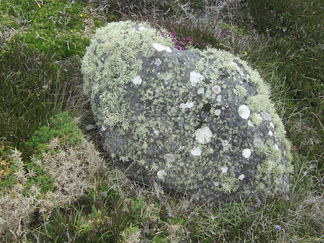
The boulder is quite small and insignificant, projecting just 30 cm above the surrounding vegetation and difficult to see because it is dark grey or black in colour and is well covered with assorted picturesque lichens and heather. The dimensions of the well-rounded boulder are c 75 cm x 45 cm x 45 cm. It looks very dense and heavy --rather like basalt. Parts of the surface are quite smooth, and parts are rough and "knobbly". I don't know of any other outcropping rocks in Pembrokeshire that look like this -- and I understand why the old geologists speculated that it might have come from Scotland or North Wales.
The best "candidate" provenance location is maybe Anglesey. See this excellent RIGS note relating to picrite erratics on the island:
https://www.geomon.co.uk/llanerchymedd-rigs-site/
Once upon a time the boulder was in a cage, to stop people from bashing bits off it -- now it has been set free in a different position, and I can see no damage on the surface. Let's hope it stays that way.
This is an outcrop of the St Davids PreCambrian granophyre -- white, flinty and very different from the blackish picrite erratic........
Tuesday, 30 May 2023
Stonehenge Visitor Centre -- more nuanced messaging?
Thanks to Caroline Beaton for sending a photo taken recently in the Stonehenge Visitor Centre. It's good to see that the only decent book on the bluestones is displayed quite prominently, as one would expect. May it continue to sell well, as it has done over the past few years.
Caroline tells me that "there is now a panel in the interpretation centre which mentions that it is not known for sure how the bluestones came to be included at Stonehenge and that there are several theories.
So they are not saying the dragging them there from Wales theory is right!"Caroline says that there is now a better balance in the way that EH is openly discussing the issue and candidly stating there are several theories but no conclusions. Videos also state this quite openly.
This is after all what one might hope for from the custodians of the site, who have a responsibility to offer context and summarise the latest findings and theories.
Contrast this with the recent British Museum exhibition which suggested that the word "dispute" did not exist in the English language........
Monday, 29 May 2023
Carreg Samson
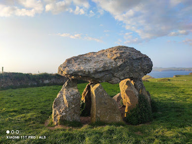
Thanks to Alun Roach for posting these pics on Facebook. Carreg Samson is a rather splendid cromlech near the north Pembrokeshire coast -- in the most spectacular of settings. It is supposed to have been created in the Neolithic, about 5,500 years ago. There are six uprights and a capstone. As we can see, the stones used in the construction are varied -- all erratics, and all used (as usual) more or less where found. The burial chamber was constructed in a pit -- thought by the archaeologists to be the excavation pit from which the capstone was lifted. So this cromlech was built exactly where a potential capstone was found; the uprights might then have been imported from a short distance away.
That's a rather utilitarian conclusion relating to the cromlech's location -- unlike other suggestions which are a good deal more romantic and imaginative.....
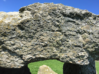
Here is a photo from Alan Hughes, showing the capstone in close-up.
The geology has not been well described -- but at least three of the stones are made of Ordovician dolerite, and the capstone, like one of the uprights, is made of what appears to be a rough volcanic agglomerate or ignimbrite, probably derived from one of the local igneous outcrops. This might be the rock referred to by BGS as a pyroclastic "crystal tuff" belonging to the Llanrian Volcanic Formation.
Grid ref: SM 848335
Saturday, 27 May 2023
The Porthlysgi picrite erratic
This is one of the most famous glacial erratics in Pembrokeshire, close to the cliff edge near Porthlysgi. Once upon a time it was in a cage, to stop people from collecting chunks of it; then it fell over the cliff edge onto the beach below; and later still it was rescued with the aid of a helicopter and replaced on the clifftop, to the north of the footpath.
It is reputed to have come from North Wales. Here is an excellent description of it, on the web:
ht;tps://historypoints.org/index.php?page=glacial-erratic-boulder-porthlysgi-st-davids
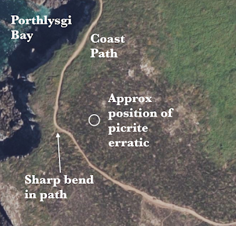
The boulder is about 30m N of the coast path, at grid ref SM 73199 23361.
Correction: This Google location point is in the wrong position. The boulder is further to the west, north of the coast path at grid ref SM 73108 23383
Wednesday, 24 May 2023
The fourth ancient till site in Pembrokeshire
I'm adding Traeth Mawr, Newport, to my list of ancient cemented till sites in Pembrokeshire. The other three are:
1. Black Mixen, Lydstep
2. Ceibwr
3. Witches Cauldron, near Ceibwr
I have described these in other posts. The Newport exposure is on the beach, directly in front of the public car park, and for much of the year it is hidden beneath the beach sand. But in the winter, or following storms, the ancient till -- solidly cemented -- is exposed and easy to examine.
The till is so solidly cemented with iron oxide and manganese oxide cement that you cannot extract any stones from it. the erratics -- mostly less than 30 cms long -- are faceted and heavily abraded, and are of many different rock types. Sedimentary rocks (mostly sandstones and quartzites) predominate, but there are some igneous erratics as well.
I don't think these are recently cemented Devensian deposits, since there are fresh till exposures between the tide marks in the estuary on the inside of the sand dunes. There is no obvious reason why till should be cemented on the outside of the dunes and uncemented on the inside -- the obvious conclusion is that the tills must be of two different ages.
Monday, 22 May 2023
The West Angle till
I took a look at the West Angle section a couple of days ago, and while most of the section along the sea front remains rather messy and covered by vegetation, there is a good exposure of the till, with one particularly fine ORS cobble with crossing surface striations. The striations are quite shallow, but you can feel them with a finger, and this confirms to me that this is an in situ till and not something that has been subjected to periglacial or paraglacial redistribution. Higher in the sequence, there has been a lot of redistribution, and that is why I have referred to the deposits as "stratified dark red gravelly deposits" reminiscent of the deposits so spectacularly exposed at West Dale.
I have done many posts on West Angle. Use the search box to find the links.
The dark blue silt and clay series is also well exposed at present, just above beach level.
One feature that is more prominent now than in past years is the rocky outcrop at the northern end of the exposure, close to the cafe. On the foreshore there are exposures of broken Lower Limestone Shales, but in the cliff face the orange-red materials are not sediments at all (except at the top), but thoroughly rotten bedrock. This seems to me to be the source of at least some of the "silt and clay series" which has been interpreted as interglacial, lying stratigraphically beneath the dark red till which fills an eroded gully.
Sunday, 21 May 2023
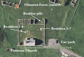
The Flimston erratic cluster
Today, in perfect early summer weather, we spent a happy hour mooching about in Flimston Churchyard, looking at erratics. And very fine they are too........
There are seven big erratic boulders in the churchyard, four of them in a row near the stone cross monument, used as memorial stones or headstones for members of the Lambton family. Grid ref: SR 92386 95590. In the following notes they are numbered as on the photo above. They are on the west side of a slightly raised mound which marks the grave sites, bounded by smaller limestone boulders gathered locally. The other three erratic boulders are about 15 metres away, in the NE corner of the churchyard. Grid ref: SR 92403 95595. They are recumbent, and were probably brought here with the intention of using them as headstones -- but they were never used. All seven of the boulders were gathered up from the surrounding area -- the most distant about 3.4 km away.
These are not the only Flimston erratics. There are several small igneous erratic boulders in the walls around the churchyard, and over the wall, in the NE corner, there is a pile of small boulders, at least ten of which appear to be igneous. Grid ref: SR 92407 95604. At one time, this was a roofed farm building (the ruined Flimston Farm is immediately adjacent) and I think the boulders were probably dumped here following field clearance.
The pile of "field clearance" boulders just outside the churchyard wall. At least ten of them are igneous.BOULDER 2 (FWL)
BOULDER 3 (GCL)
BOULDER 4 (CAL)
This (no 3 of HHT) is the most massive of the boulders, not elongated, and probably not deeply embedded in the surface. Dimensions 90 x 90 x 80 cms. Heavily abraded, with no signs of fractures, but some very old and abraded facets and surface pitting. Edges all rounded off. A blue-grey colour -- unspotted dolerite or diorite similar to boulder 2, but appears more fine-grained. Referred to as a diabase by HHT. Found at Merrion Pond, about 2 km to NE, grid ref SR 937 971. Source: probably one of the PreCambrian outcrops on the north or south shore of St Brides Bay?
THE CLUSTER OF THREE
This is a large rough boulder, recumbent, with dimensions 110 x 90 x 60 cms. Some large fracture scars, including one on the uppermost surface. Another welded tuff or pyroclastic ashflow rock -- many brecciated fragments but not as "spherulitic" as boulder number 1. Dark blue colouring. Found at Lyserry Farm or Valast Hill Farm, 3.4 km ENE, at grid ref SR 955 966. Is this HHT's stone no 3, "a quartz-porphyry with pink felspars" probably from a non-Welsh location?
BOULDER 6
A very large elongated boulder, recumbent, dimensions 180 x 90 x 55 cms. Light grey-blue colour. A rhyolite (?) or lava, but not as rough as boulder 3. Prominent fracture scars. Flattish undulating top. In places, a slightly orange colouration. A PreCambrian rhyolite from near Porth y Rhaw? Found at Lyserry Farm or Valast Hill Farm, 3.4 km ENE, at grid ref SR 955 966. This might be HHT's boulder no 5, "a quartz porphyry of unknown origin"? But we have no visual record of the boulders and their allocated numbers.
BOULDER 7
A smaller boulder, also recumbent. Dark blue or blackish colour -- dimensions 120 x 60 x 40 cms. Coarse texture -- possibly a gabbro. Some broken facets, but heavily weathered and again much of the surface covered with lichen growths. Found at Lyserry or Valast Hill Farm, 3.4 km ENE, at grid ref SR 955 966. This might be HHT's boulder No 4, referred to as "a diabase, probably from the Prescelly Mountains" -- but I think it looks more like the St Davids Head gabbro.
Conclusions
Each of these boulders appears unique -- I suggest that they have come from 7 different locations, most likely near the tip of St Davids Peninsula or Ramsey Island or the Bishops and Clerks. Could boulder 1 have travelled due south from the west side of Pen Caer? Not very likely, but not impossible........ And could boulders 5 and 6 have travelled from outside Wales? HH Thomas suggested that some of the erratics on the limestone flats of the Castlemartin Peninsula might have come from the uplands of Preseli -- including a big "spotted diabase" boulder in Loveston farmyard. However, I have not seen any evidence to support that suggestion.
Anyway, this is the first time these boulders have been systematically described. I hope this will encourage further research from those who are better qualified than I am in matters petrological!
======================
https://pubs.bgs.ac.uk/publications.html?pubID=B01825
Wednesday, 17 May 2023
Bring home the bluestones!
It's good to see that my friend Derek Webb is having great success with his play about the bluestones -- and a campaign to get them back to Pembrokeshire, where they of course belong. While they are about it, EH can donate the sarsens as well, in compensation for them maximising the commercial exploitation of the bluestones for so many years, leaving Wales impoverished.
Previous performances of the play have been in Fishguard, but now it is moving to Anglesey and the English Midlands, where performances will no doubt be accompanied by much hilarity.
Ramsey Island -- a major source of glacial erratics
I have posted on the geology of the island before:
https://brian-mountainman.blogspot.com/2016/01/ramsey-island-geology.html
https://brian-mountainman.blogspot.com/2015/01/ramsey-island-as-major-source-of.html
The darker coloured "giant erratic" on Ramsey Sound may have come from further north on the island; one of the boulders in the Storrie Collection (from Pencoed in Glamorgan) is assigned by Bevins and Donnelly to one of the volcanic debris flow outcrops of Ramsey; and it may be that some of the fine-grained lava erratics from St Bride's Haven are also from Ramsey. Somebody needs to do a systematic study.
Might the Limeslade erratic also have come from Ramsey? I have some doubts about that, since the initial analyses suggest it is a metamorphosed coarse dolerite with a greenish colour, and I don't think such a rock type exists on Ramsey Island. Watch this space.......
So if, as seems highly likely, large numbers of erratics have been entrained from Ramsey Island, it's intriguing that there are no obvious plucking or quarrying sites on the lee (or downglacier) flank. The boulders -- sometimes weighing hundreds of tonnes -- have apparently been incorporated into the ice on the western and south-western hill masses, perhaps with later moulding removing all traces of the "extraction locations."
This suggests to me that the assumption (which we often see in the literature) of moulding on the upglacier flanks of obstacles, and plucking (and erratic entrainment) on the downglacier flanks, is not very reliable. The island does not have an obvious roche moutonnee shape. I have of course also suggested that bluestone erratic entrainment on Preseli happened preferentially on the northern -- or up-glacier -- side of Mynydd Preseli, and I have discussed this at some length with various glacial geomorphology colleagues. Again, watch this space......
Erratic, but precious......
In this country, Birmingham is showing us the way by treating its scatter of erratic boulders as precious assets. On scanning through one of my photo albums I came across this one -- a glacial erratic in New Jersey, somewhat too heavily protected maybe.........
But maybe it really is a precious one -- a unique boulder from a very significant source, providing a key bit of evidence about directions of ice movement in the last glacial episode.....
Monday, 15 May 2023
More erratics on the Isles of Scilly -- and maybe some more till
Samson. There is a piece of rounded flint on the west coast of South Hill. There are also a couple of erratics in the ram (slope breccia) on the west coast of North Hill, Samson.
St Mary's. On Bar Point, the northern tip of the island, erratics embedded in horizontal ram can become exposed when sand washes away from the beach.
Annet. The west coast of the island has very little ram cliff and is mostly boulders piled up, but there is a short section of exposed ram at the southern end with middens showing, but there may not be any erratics there. There is a peat layer low in the cliff on the eastern side.
Tean. There are very good in situ glacial deposits, particularly facing Round Island.
Men a Vaur (west of Round Island). There are traces of ram containing sandstone erratics.
Little and Middle Arthur in the Eastern Isles. There are erratics in ram on the neck between the two small islands. The deposit seems to have been reworked -- and it also contains bits of broken bottle!!
Porth Killier, St Agnes. There are sandstone erratics in the really good raised beach sections exposed along the coast.
Guthers (in the sound between St Martin's and St Mary's). There are also some really good raised beach exposures here, also containing flint and sandstone.
Some of the erratics discovered are exposed in ram, close to areas of raised beach. They could have been moved around (more than once!) before becoming embedded. The flints on Samson are both near to bits of raised beach, but they do not seem to be associated with the beach exposures.
Periglis, St Agnes. At low tide in the bay, there are thick, sticky clay deposits under the sand, which are redder than the more orange ones near White Island, St. Martin’s. There is a strong chance that this is a "fresh" till related to the exposures at Chad Girt. Similar deposits are found in some of the bays of the South Pembrokeshire coast, for most of the time buried beneath beach sand.
Tuesday, 9 May 2023
The ResearchGate phenomenon
=======================
WHAT IS RESEARCHGATE?

ResearchGate.net is an academic profile and social networking site, and a popular hub on the web for sharing academic publications.
ResearchGate is a private company attempting to monetize academic publishing, and it does not vet whether it has a license to host a publication.
WHY USE IT?
Many researchers and scientists will post PDFs of their articles on ResearchGate, so it is a source of free scholarly articles. They are often indexed by Google Scholar.
HOW TO CITE FROM RESEARCHGATE
ResearchGate is not a publisher.
ResearchGate is not a journal.
It is simply an academic social network, and any articles on it should be cited using their own citation information, with no mention of ResearchGate.
While reading articles does not require registration, people who wish to become site members need to have an email address at a recognized institution or to be manually confirmed as a published researcher in order to sign up for an account. Members of the site each have a user profile and can upload research output including papers, data, chapters, negative results, patents, research proposals, methods, presentations, and software source code. Users may also follow the activities of other users and engage in discussions with them. Users are also able to block interactions with other users. A study found that over half of the uploaded papers appear to infringe copyright, because the authors uploaded the publisher's version.
As of 2020, it has more than 17 million users, with its largest user-bases coming from Europe and North America. Most of ResearchGate's users are involved in medicine or biology, though it also has participants from engineering, computer science, agricultural sciences, and psychology, among others.
ResearchGate does not charge fees for putting content on the site and does not require peer review.


