THE BOOK
Some of the ideas discussed in this blog are published in my new book called "The Stonehenge Bluestones" -- available by post and through good bookshops everywhere. Bad bookshops might not have it....
To order, click
HERE

Thursday 27 December 2018

Wave-cut rock platforms, Newport Pembs


Some pics from our  Christmas Day walk on Traeth Mawr, Newport.  There was a very low spring tide, so access to the northern end of the beach was easy -- and the splendid wave-cut platforms were clear of overlying sediments (sometimes large parts are covered by the sand).

As we can see, the platforms are cut across the mudstone, shale and sandstone strata (the cliffs here reveal very convoluted folding and faulting structures) and there is a very sharp break at the foot of the cliffs.  The pebble beach is not very well developed here -- but the pebbles in these beaches are clearly the tools use by the waves in the fashioning of the platform.  Surface relief on the platform is generally around 50 cms -- but in places it is more than 1 m.  Distinct gullies have been formed by the backwash of the waves.  All of the platform remnants are below HWMST.

The bottom photo shows a clear break in the platform near mid-tide mark, not far from the Boat Club and car park.  There is a clear step about 1 m high, between an extraordinary flat platform cut across black mudstones, and a more irregular platform above.  I can see no geological explanation for this feature.  Elsewhere beneath these cliffs there re other slight steps as well -- and I am convinced that we are looking at multiple platform remnants here, of different ages.  Are some of them Ipswichian in age (around 100,000 years old)/  And could some remnants be even older -- ie from earlier interglacials?

We like to think that the Ipswichian raised beach platform is well above HWST (as at Poppit, Porth Clais  and Broad Haven South) -- but things are clearly not that simple......


Tuesday 25 December 2018

A little bit of landscape evolution

The perched boulder after the storm -- October 2018

The perched boulder 2 months later -- December 2018.  We have had a lot of rain, and 
it has come crashing down..... 

In October 2018, following a large gale that brought down a tree at the end of our garden, I did a post on the rapid transformation of the landscape.  The thing that interested me most was the manner in which the rootstock of the falling tree had lifted up a large boulder to a position where it was about 2m above the ground surface.

https://brian-mountainman.blogspot.com/2018/10/another-biological-process-explains.html

Now, after two months of very wet weather -- including a number of deluges -- the boulder has slumped down from its pedestal and is resting on the ground surface again.  Another interesting thing is that some of the soil from the rootstock has also washed down, and is resting on the old ground surface.  In years to come, this means there is an inversion of the stratigraphy, with older deposits resting on top of newer ones.

This sport of inversion occurs with landslides and avalanches, on a large scale, and with minor slope failure events on a small scale.  So the message is this -- we can interpret most stratigraphic sequences in straightforward terms (top layers younger, lower layers older) but maybe we should not be too surprised when every now and then we encounter something anomalous.......


Sunday 16 December 2018

The dating of the Somerset ice lobe and the nonsense of aminostratigraphy


Here is a post from 2015, reminding is of the utter confusion surrounding the last glaciation of the Somerset Lowlands.  Recently, I have been studying (again) the GCR Review book called "The Quaternary of SW England" (1998) and the "little yellow book" published by the QRA in 2006 -- the Quaternary of Somerset Field Guide.  

Between them, these are taken widely as the definitive guide to what went on in the Ice Age in Somerset and the adjoining counties.  Sadly, I have to recommend readers to ignore almost everything that they read about the dating of events.  Take on board by all means the descriptions of site stratigraphy and the records of fossil content etc at the numerous sites analysed -- but when it comes to lithostratigraphy and "aminostratigraphy" think very carefully about what you read.  Why?  Because amino acid dating of organic materials is so difficult that after 30 years or more its reliability has still not been proved -- especially when used for the dating of shell and bone samples. In the dating of UK glacial and glaciofluvial samples, and in interglacial deposits, the over-use of this dating technique in its exploratory or experimental phase has caused mayhem.  Under the influence of Prof DQ Bowen -- its leading proponent -- amino acid dating was used on hundreds if not thousands of Quaternary samples, giving results that were wildly out of step with other dating results.  But because they were deemed to be more reliable and sophisticated they were given preference. The result?  Complete mayhem -- especially between 1990 and 2010.

The confusion surrounding the over-dependence on the amino acid dating technique was analysed by Prof Danny McCarroll in 2002:
https://onlinelibrary.wiley.com/doi/pdf/10.1002/jqs.690

When the GCR Guide and the "little yellow book" were being written, Prof DQB was involved with everything, and the amino acid results from his lab and other labs were everywhere, being fed into numerous "re-interpretations" of Quaternary events.  Read the two volumes and you will see what I mean..........  it is almost impossible to make any sense out of anything.

As I have said before, "aminostratigraphy" is a nonsense term -- it assumes that you can make stratigraphic correlations on the basis of amino acid  dates alone, even if they are based upon samples of different materials, in different quantities and states of preservation. Lithostratigraphy is difficult enough already, but it has taken a serious hit because of the attempts to marry it to this mythical creature called "aminostratigraphy."

Thirty years (at least) have been lost, and we'd better get back to basics.  A reminder of what Ann Bridle wrote in 2012:


Glacial confusion in North Somerset

My comment:  
There is great confusion in the specialist literature about precisely when the last glaciation of Somerset occurred. (Just for the avoidance of doubt, there is no doubt that there was one -- the evidence is there to prove it....) I have been looking at this interesting PhD thesis by Anne Bridle, and she summarises very nicely where the confusion occurs. Much of the problem has to do with the use of dating techniques, with several now available. In 2006 it was widely assumed on the basis of "aminostratigraphy" (ie stratigraphy based on the use of the amino acid dating technique of calcium carbonate materials like marine molluscs) that the last glaciation of this area was during Marine Isotope Stage 16 or even before that. however, there seem to have been major problems over calibration, and it now looks as if the deposits date from MIS 12 -- ie the Anglian Glaciation. This is much more consistent with the evidence appearing from all over the place...... and of course it ties in much more neatly with recent dating of glacial deposits in Eastern England.

Bridle, A. (2012) The mid-to-late pleistocene palaeoenvironments of the Gordano Valley, North Somerset.
PhD, University of the West of England, Bristol.The publisher’s URL is
http://eprints.uwe.ac.uk/18104/

Extract from Chapter 2

Devensian (MIS 2) ice is assumed to have been confined to the north of the Severn Estuary (Jones & Keen 1993, Clark et al. 2004), all deposits in Somerset interpreted as glacigenic having been attributed to earlier (pre-MIS 2) glaciations (Bowen 1973a, Hunt 1998b, Evans et al. 2005). In keeping with the generally accepted age of the most southerly extent of ice when the deposits were first described, the age of the Somerset glaciation was originally assumed to be Wolstonian (MIS 6) (Hawkins 1972, Gilbertson 1974, Gilbertson & Hawkins 1978a) or earlier (Gilbertson & Hawkins 1978a, Andrews et al. 1984). The deposits were later assigned to either a MIS 10 or Anglian (MIS 12) glaciation (Hawkins 1977, Bowen et al. 1986, Jones & Keen 1993, Kellaway & Welch 1993, Keen 2001, Harrison & Keen 2005) and some have since been considered to be MIS 14 or 16 (Bowen 1991, Hunt 1998a). Deposits interpreted as till, possibly pre-MIS 15, are recorded at Kenn 4 km south west of the Gordano Valley, and may extend as far south as Greylake Quarry on the Somerset Moors (Hawkins & Kellaway 1971, Gilbertson & Hawkins 1978a and b, Hunt 2006a and e). Gravels interpreted as till and glacial outwash on the margins of the Gordano Valley (described in Chapter 3) have been correlated with this glaciation (Campbell et al. 1998, Hunt 1998a, Bowen 1999b, Campbell et al. 1999). Its age is uncertain, but it antedates MIS 5e and covered most of south Wales and undefined areas farther south (Bowen 1973a, 2005). 

At Kenn, gravel interpreted as till is overlain by younger interglacial deposits. Amino acid analysis of Corbicula fluminalis shells from these deposits indicates MIS 15 deposition (Andrews et al. 1984, Bowen et al. 1989), suggesting that the glacial deposits are MIS 16 or older. However, Hunt (2006h) advised that ratios obtained from Corbicula fluminalis are problematical, a view supported by Penkman et al. (2007). In their recent reappraisal of aminostratigraphy of the southern part of the North Sea Basin, Meijer and Cleveringa (2009) considered the AAR results for Kenn Pier and Yew Tree Farm to be aberrantly high; similarly high ratios have been reported for Corbicula fluminalis from Purfleet, Essex, which is assigned to MIS 9 on the basis of mammal biostratigraphy (Schreve 2001a). Meijer & Cleveringa (2009) suggest sampling was from the shell umbo, in which case the ratios are consistent with a MIS 9 age. Furthermore, the presence of Corbicula fluminalis is inconsistent with MIS 15 age as it is only known from pre-MIS 19, MIS 11, 9 and 7 deposits (Meijer & Preece 2000, Keen 2001, Meijer & Cleveringa 2009). This indicates that the Kenn deposits are more likely to be MIS 11 or 9, which would place the glacial deposits in MIS 10 or 12 (Keen 2001, Harrison & Keen 2005, Westaway 2010b).

It has been suggested that at the height of this glaciation ice advanced eastwards up the Bristol Channel, affecting both sides of the Bristol Channel and impinging on the Somerset coast (Figure 2.6A) (Campbell & Bowen 1989, Ballantyne & Harris 1994), whilst ice derived from Wales may have blocked the Severn Estuary (Gilbertson 1974, Green 1992). Stephens (1970) suggested that this combination of ice, pressing southwards against the coast, may have formed a pro-glacial lake in lowland Somerset, the limits of which were controlled by the Bristol Channel ice front and the surrounding high ground. However, there is no unequivocal evidence for glaciation of the Mendips or south Somerset; consequently this scenario has been dismissed (Hunt et al. 1984, Farrant & Smart 1997, Hunt 1998b).

Despite there being little evidence for the limits of a pre-MIS 15 glaciation (Harrison & Keen 2005), Gilbertson & Hawkins (1978b) were able to infer its extent and direction of ice flow, and this is illustrated in Figure 2.6B. Their direction of ice flow agrees roughly with evidence for a glaciation of uncertain age, usually correlated with either Anglian (MIS 12) or Wolstonian (MIS 6) stages, found on the northern plateau of Lundy Island where there are extensive scatters of pebbles of erratic lithologies at 107 m above Ordnance Datum Newlyn (OD; the standard mean sea-level datum for Britain) and where west-north-west to east-south-east ice movement across the island has been inferred from ice moulded granite (Bowen 1973b, Harrison & Keen 2005).

Friday 14 December 2018

Scottish National Library map resource


Sadly, Where's the Path is discontinuing, after providing a fantastic service for people hunting for locations.  Apparently they can no longer afford the fees charged by Google for the provision of satellite imagery.  They always had problems with the OS too, being allowed only so much customer usage per day for copyright materials.

But the Scottish National Library rides to the rescue.  They are now providing a very similar service for free, using old OS maps (up to 6" scale) on the left and Bing / Microsoft satellite  imagery on the right.  It works well, as far as I can see -- and gives a grid reference for wherever the cursor happens to be.

https://maps.nls.uk/geo/explore/side-by-side/#zoom=10.993333333333334&lat=51.1888&lon=-2.8079&layers=161&right=BingHyb 

I have already used it quite a bit.

Stonehenge was built by cows


Silly season again. It would have been much more fun if it was about reindeer, but we can't always have what we wish for. Anyway, this is the latest big Stonehenge story, seized with glee by the media........ based on a new research paper in Antiquity (whose peer reviewing procedures are, as we know, somewhat dodgy).

The article has nothing to do with Neolithic Britain, let alone Neolithic Stonehenge, but that hasn't stopped the Daily Mail and the Daily Telegraph from getting all excited.  As the Mail Online says:  Forget horsepower, Stonehenge was built with COW-power: Cattle that lived 8,000 years ago were used as 'animal engines' to lug around heavy objects for Neolithic people.  Wonderful stuff. Studied cattle foot bones from "Neolithic contexts"are assumed to have come from domesticated cattle, but that is by no means certain.  This is a matter for zoologists and bone experts, but I'm not sure how they would demonstrate that the effects on the bones were down to heavy pulling rather than being a consequence of these cattle living and moving about in a heavily-wooded  and mountainous environment.  I hope there are control studies involving "normal" or known wild cattle.......

But all good fun.........

    Antiquity, Volume 92, Issue 366
    December 2018 , pp. 1462-1477

    Gaining traction on cattle exploitation: zooarchaeological evidence from the Neolithic Western Balkans

    Jane S. Gaastra, Haskel J,. Greenfield and M. Vander Linden

    https://doi.org/10.15184/aqy.2018.178
    Published online: 11 December 2018
    https://www.cambridge.org/core/journals/antiquity/article/gaining-traction-on-cattle-exploitation-zooarchaeological-evidence-from-the-neolithic-western-balkans/4D7976886FE66AF19A956ADA45FAA376

    ================

    Abstract

    The study of the exploitation of animals for traction in prehistoric Europe has been linked to the ‘secondary products revolution’. Such an approach, however, leaves little scope for identification of the less specialised exploitation of animals for traction during the European Neolithic. This study presents zooarchaeological evidence—in the form of sub-pathological alterations to cattle foot bones—for the exploitation of cattle for the occasional pulling of heavy loads, or ‘light’ traction. The analysis and systematic comparison of material from 11 Neolithic sites in the Western Balkans (c. 6100–4500 cal BC) provides the earliest direct evidence for the use of cattle for such a purpose.

    =======================

    Bos taurus metatarsal from Kneževi Vinograd showing sub-pathological remodelling to the medial condyle resulting from traction usage. This bone was directly dated to 6015–5897 cal BC (photographs by J. Gaastra)

    https://www.arch.cam.ac.uk/gaining-traction-cattle-pulled-loads-2-000-years-earlier-than-previously-thought

    Press release:
    Gaining Traction: Cattle pulled loads 2,000 years earlier than previously thought
    Dec 12, 2018 12:00 PM

    Cattle were being used to pull loads as early as 6,000 BC according to new research, providing the earliest systematic evidence of animals being used as engines.

    In the study, published in Antiquity, archaeologists discovered that the bones in the feet of Neolithic cattle demonstrated distinctive wear patterns, indicative of exploitation as ‘animal engines’. If these practices can be proven elsewhere, it is expected to have major ramifications on our understanding of animal use in the Neolithic.

    Lead author Dr Jane Gaastra of UCL's Institute of Archaeology, said: “We have been able to provide the first conclusive evidence that farmers were using cattle for ‘traction’ almost 2,000 years earlier than the previous consensus date. There has only been one other foot sample from the Neolithic period found in Syria, but this was inconclusive.

    “The part of the Balkans where we found the bones was heavily forested in the Neolithic period, so chopping trees to create settlements would have required lot of person power. Cattle would therefore have been a vital asset helping to transport items such timber for housing.”

    The study, stemming from the EUROFARM project funded by the European Research Council, was conducted in the central and western Balkans and shows that the earliest European farmers were not simply using cattle as a source of meat or dairy products, but also as a source of propulsion. The findings indicate that traction in some form, and not necessarily through the use of ploughs or wagons, was present much earlier than previously thought.

    Most other studies have focused on the use of traction in much later periods, because it has often been conflated with ploughing or the use of carts which came much later.

    Co-author Dr Marc Vander Linden (University of Cambridge), said: “Until now it has generally been considered that traction only emerged by the 5th and 4th millennium BC, parallel to the introduction of the plough and the wheel, but our study demonstrates that this is not the case.

    “We reveal that when the wheel and the plough became available farmers were already experienced in using cattle for traction, and this could have facilitated the spread of these innovations.”

    While ploughing and cartage are forms of traction, they represent only two types of activity on a much broader spectrum of exploitative practices from specialised animals bred and used for regular work through to animals used for more occasional pulling activities, or for regular labour over a short number of years.

    The researchers investigated 12 cattle foot bone samples, from both male and female cattle (predominantly cows), from 11 Neolithic sites in the central and western Balkans (modern-day Croatia, Serbia, Romania and Bosnia-Herzegovina) spanning from 6,000 to 4,500 BC. The sites were open air settlements from multiple phases of the Neolithic.

    Foot bone was chosen as it is most affected by the stress of pulling and happens to be most commonly preserved in the archaeological record. In determining traction, the archaeologists were looking for extra bone growth in the inner part of the foot, as this is typically where the foot takes most of the load.

    The researchers hope to replicate the study in other European regions to determine the extent and duration of this form of traction. It is still unknown whether this form of traction is seen in only a selection of Neolithic groups or was a common practice across Europe. A firm understanding of the nature of early traction evidence in prehistoric Europe has significant implications for our knowledge of both management practices and the nature of labour and movement in prehistoric societies.

    Dr Gaastra concluded: “What is now needed is a wider comparative assessment of sub-pathological evidence for cattle traction in Neolithic (and post-Neolithic) Europe to determine both how widely this pattern of early traction was distributed and at what point we begin to see evidence for specialised heavy-traction animals.”

    The article is published online today in Antiquity. Gaastra, J., Greenfield, H., & Linden, M. (2018). Gaining traction on cattle exploitation: Zooarchaeological evidence from the Neolithic Western Balkans. Antiquity, 92(366), 1462-1477. doi:10.15184/aqy.2018.178

    The project is funded under the European Union’s Seventh Framework Programme, Social Science and Humanities Research Council of Canada and the University of Manitoba, the International Research and Exchanges Board of Washington, D.C. and the Fulbright-Hayes Program.

    Thursday 13 December 2018

    More on Lake Maw (Somerset)


    In 2015 I posted these two spectacular images from Russell Glacier in West Greenland, showing partly-drained pro-glacial lakes.

    https://brian-mountainman.blogspot.com/2015/11/pro-glacial-lakes-russell-glacier-w.html

    I am now rather intrigued by the question:  could something similar have occurred in Somerset at the end of the Anglian Glaciation? (Or maybe at the beginning of it?  Remember that the biggest damming of Lake Teifi in West Wales is now thought to have occurred as the ice of the Irish Sea Glacier arrived -- not as it wasted away......)

    There are fantastic details on these images, including faint shoreline traces related to earlier water levels, the shoreline or washing limit created by the highest water stillstand, and the surprising survival of pre-lake landforms and sediments after submergence for an unknown length of time.  I'm also intrigued by the apparent lack of thick lacustrine deposits on the old lake bed.  What we see is a litter of erratic boulders which might have been emplaced by the glacier when it was in an expanded state -- pre-submergence -- or possible emplaced as dropstones from the abundant floating ice debris such as we see in the lower photo.

    Here is an interesting article:
    https://www.researchgate.net/publication/233495943_Glacier_advance_ice-marginal_lakes_and_routing_of_meltwater_and_sediment_Russell_Glacier_Greenland

    Most lakes of this type last for decades rather than centuries or millennia.  Details are given in this and other studies of ephemeral lakes relating to the short-lived oscillations of the ice edge, the routing of escaping meltwater across cols (where overflow channels may be created) and the sediments transported and deposited.  One particular focus of interest is the manner in which jokulhlaups (catastrophic drainage floods) occur -- but shoreline and lake bed features have received much less attention.


    Here is another image from West Greenland, showing pro-glacial lakes (with cloudy or sediment-rich water)  impounded as a result of the details of local topography.  Sometimes lakes are connected together in strings, and sometimes there are complex connections across submerged cols.  The retreating ice sheet edge is on the right.  Note the uplands with small glaciers and snowfields (with clearwater lakes) in the bottom left quadrant of the image.  We can pick up the main drainage routes leading from the pro-glacial lakes towards the coast  -- along these routes sediments are deposited and terraces may be formed.


    Back to Lake Maw.  On the map by Prof Nick Stephens he suggests that the Saalian / Anglian lake (if it really did exist) was impounded by an ice edge running along the middle of the Severn Estuary and located maybe somewhere near Flat Holm.  He suggests that most of the water in the lake came from melting on the ice front and from the impounded or trapped Severn River, submerging an extensive area across the Somerset Levels including the sites of Bridgwater and Burtle (where the famous Burtle Beds are located). He suggests that Cheddar and Weston Super Mare were not submerged, but if the water level was above 82m -- which it must have been, for water to flow over and through the Chard Gap -- then the lake must have been much more extensive on its northern flank. 

    Clearly, the nature of the sediments beneath the peat beds in the Somerset Levels are critical in the arguments about the existence of Lake Maw -- I'll take a look at that particular matter in another post. 


    A fine photo by Andy Russell of two of the Icelandic pro-glacial lakes held up against a hillside by very dirty ice -- and in the process of breaching the ice bridge that separates them.  Soon there will be just one lake here -- unless a catastrophic breakout occurs, in which case there will be a flood and the lake(s) may drain completely.

    Wednesday 12 December 2018

    Intersecting outlet glaciers and glacial troughs, SE Greenland


    According to ancient tradition, I occasionally post something spectacular from the world of ice.  This is a Google Earth image of intersecting glaciers and glacial troughs in SE Greenland.  The biggest glacier is calving into a fjord at bottom left.  Glacier crossings of this type are very rare, since glacier systems generally try to maintain "brutalised" dendritic patterns which evacuate ice most efficiently.  This is all very difficult to work out, but it sure is interesting......

    Severn Estuary -- the glacial context


    The area shown in this map is crucial for our understanding of what happened during the Quaternary, and what the string of events might have been which resulted in the hypothesised glacial transport of the bluestones. The distribution of upland and lowland is crucial; during glacial episodes uplands tend to accumulate snowcaps or even small ice caps, and ice coming in from further away (ie ice from the Welsh ice cap of the ice of the Irish Sea Glacier) will always tend to fill depressions first and then spill out of them under the influence of the ice surface gradient and the dynamism of the ice mass.  Those who have, in the past, drawn "straight line" ice edges across this territory have portrayed situations that can never have happened.  In this sort of terrain, all ice edges must have been crenulated.  Where exactly they were located during the Anglian and the Devensisn glaciations (and maybe others as well) is still open to debate!

    The pattern or rivers shown here is inherited to some degree from pre-Pleistocene times,and some details will be down to diversions linked to ice action and meltwater overspills from pro-glacial lakes.

    I'm giving a lot of thought just now to that latter issue.  How and where might substantial bodies of meltwater been impounded?  Was there dead icei n the depressions, with a ribbon of meltwater between of the ice and the containing hillsides?  Were the water bodies joined together -- with a common surface level?  And was there a vast expanse of water across the Somerset Levels, with hill masses standing above the surface as islands?  If so, how much debris was introduced into this water body by the melting ice, and where are the resulting deposits?

    Interesting questions -- watch this space......

    Tuesday 11 December 2018

    Mud, mud, glorious mud........


    There is something rather wonderful about tidal estuaries at low tide, when all the mud banks are exposed.  This particular scene is from Slebech Park, well up the Eastern Cleddau (also called Cleddua Ddu or "Black Cleddau")  and a few miles from Picton Point.

    There's not just mud here -- we can see in the bed of the creek that there are many boulders, and there are stony deposits exposed in the banks too.  One warm summers day, when I feel inclined, I might  check out whether any of these exposed deposits can truly be referred to as till........

    Poppit raised beach platform and overlying sediments

    I visited Poppit (at the mouth of the Teifi estuary) the other day, just to check out what might have changed since my last visit.

    The raised beach platform is as prominent as ever,  just round the corner from the main beach and most easily accessible at low tide.  But a lot of storm waves have been breaking onto the RB platform surface, and the overlying deposits are in something of a mess.  There has been a lot of slumping, and the sequence is in many places difficult to discern.

    Here are some images:

    Broken rock platform some metres above HWM but still affected by storm waves.  Much slumping here in the drift cliff, with some traces of the raised beach and much mixing of periglacial (brecciated bedrock) deposits and glacial deposits related to the Irish sea Glacier.

    At the base, c 1m of brecciated bedrock debris (head) representative of Early and Middle Devensian (?) periglacial conditions but also containing raised beach cobbles.  There is a clay-rich matrix, suggesting that this is a reworked deposit incorporated into the base of the overriding Irish Sea Glacier.  In the top part of the photo we see 1.2m of clay-rich Irish Sea till with apparent shear structures.  Above that, a 1m thick glacial deposit with a greater sand and gravel content, suggestive of flowtill deposition during ice wastage.  At the top of the section, a darker sandy deposit which might be sandloess.

    This section is a bit of a puzzle.  Bottom left -- the exposed surface of the RB platform, here composed of thin-bedded soft dark shales.Above that (at the base of the section) a 30 cm layer of convoluted brecciated  bedrock fragments incorporating larger local sandstone clasts and erratics.  Above that, up to 50 cms of brecciated sandstone and shale rubble held in a matrix of silt and clay.  Well-rounded RB cobbles are incorporated.  This is probably a basal glacial deposit incorporating periglacial and interglacial deposits.  Above that, up to 1m of relatively stone-free flow till (?) with more sandy materials towards the ground surface.  

    A good exposure of the raised beach platform overlain by the sequence of deposits as described above.


    I am puzzled by the layer of fine broken shale fragments at the base of the sequence.  Surely it cannot predate the raised beach?  At the moment I am inclined to think that it post-dates the beach sediments, which were protected near the innermost edge of the platform while the platform itself was subjected to severe periglacial conditions at a time of relatively low sea-level -- during the Early and Middle Devensian.

    More work needed here.......


    Saturday 8 December 2018

    The Somerset pro-glacial lake


    I have done an earlier post on this -- based largely on some of the recent glacial modelling:

    https://brian-mountainman.blogspot.com/2018/10/was-there-proglacial-lake-on-somerset.html

    The idea of a large lake covering the Somerset Levels has been mostly ridiculed in recent years, but I have been forced to think about it again by the evidence from Bleadon Hill, which suggests a terrace that might be a kame terrace or glacial lake shoreline deposit at around 82m OD.

    https://brian-mountainman.blogspot.com/2018/12/the-glaciofluvial-gravel-terrace-at.html

    When I looked around the Mendips with Alex back in October, we visited two rather interesting sites -- one at Blagdon Coombe, and the other at Crook Peak, at the western end of the Mendips.

    At the former site, at the western end of what must surely be a winding glaciofluvial meltwater channel, there is a broken up rock face of Carboniferous Limestone in the woods opposite Rickford Church, displaying some rather interesting features.

    The exposed limestone cliff faces are in the woods, on the south side of the valley, where it opens out to the west -- more or less where the head of the arrow is located.


    There appears to be a horizontal "precipitation layer" made of calcium carbonate on the vertical rock surface.  Maybe there are two layers?  Alex has made several visits to the site, and will enlighten us.  The only obvious explanation for these layers is that they represent a water surface.  But was this the surface of a lake?  And if so, when was it present, and for how long did it survive?  The only other explanation is that the water was ponded within a cave which has subsequently lost its outer flank by vast slabs of rock tumbling down into the valley.  And there does not seem to be any sign in the landscape that this has happened.  If the concretions can be dated, that would solve the problem.......

    These are the slight ridges of calcium carbonate cement, about two-thirds of the way down from the top of the photo.  They appear to be precipitation features, but they might just be solutional, etched into an older crust on the rock surface.

    I'm not sure whether Alex has done any accurate surveying here, but it looks to me from the maps that the altitude of this surface or "level" is around 82m.  Sounds familiar?

    Moving swiftly westwards to Crook Peak, there is another interesting exposure of Carboniferous Limestone on the hillside above the car-parking area on the minor road between xxxx


    There are a number of extensive exposures of slabs with smooth undulating rock surfaces which I thought at first were glacially moulded surfaces.  I have revised my opinion on that, and now think that the surfaces expose primary mega-ripples and other sedimentary surface features on bedding planes.  These planes coincide more or less with the slope of the ground surface, and here and there we can see the "steps" along which overlying strata are -- bit by bit -- breaking off, with the debris then sliding downslope and accumulating in hollows are piling up against areas of well-anchored vegetation.  We can see a bedding plane and a step in this photo:


    I don't dismiss some role for glacial erosion here, and ice may have had a "cleaning up" role.  But what I find really interesting is what happens upslope, where the limestone surface is more fractured, with a greater cover of algae and other plants, and with more rock debris littering the surface:


    I'm not sure what is going on here, since we didn't have much time for detailed observations or measurements, but in my mind I have memories from Greenland, Iceland and Antarctica, where I spent much time in the past searching for marine limits and "washing lines" created by wave sapping -- in which debris beneath the line was carried down into deeper water, and debris above it was left in place.  In Scandinavia hills with debris caps on them and water-washed lower slopes are called "kalottberg hills."


    And what is the altitude of this apparent washing line?  As you might have guessed -- around 82m.  So we have three different localities on the flanks of the Mendips with apparent traces of a water-level at around 82m -- can that really be a coincidence? 

    -----------------------

    We have talked on many previous occasions about the significance of Mendip, and the apparent signs of meltwater activity on a rather grand scale:

    https://brian-mountainman.blogspot.com/2018/10/on-significance-of-mendip-for.html

    https://brian-mountainman.blogspot.com/2011/08/strange-valleys-of-mendips.html

    I still think there may have been a small ice cap on the hills at some stage -- or maybe more than one stage -- and that great volumes of meltwater have had a substantial effect on the landscape.  Some of that meltwater might have been flowing in subglacial channels, as many authors have suggested in the past.

    Then we come to Lake Maw.  It was suggested by Maw in 1864 that there might have been a large pro-glacial lake in the inner part of the BristolmChannel at sone stage during the Ice Age -- and this idea was developed by Frank Mitchell in 1960 -- in one of the papers that had a great influence on my own work.  Later on Prof Nick Stephens thought that there might have been a great body of water trapped on the Somerset Levels, providing an explanation for some of the deeper gravel deposits beneath the peat and also explaining the substantial terraces of gravel that exist to the south, beyond the Chard Gap and in the valley of the Axe.  These terrace gravels have been examined in detail at Chard Junction, Broom and elsewhere.  The deep valley in Chard Gap was interpreted by Stephens as a spillway for  pro-glacial lake.  Other authors have dismissed Mitchell's ideas on the basis that there are no independent signs of this vast glacial lake -- but this is perhaps not surprising, given that most of the Somerset Plain is today deeply buried beneath peat layers.  Also, those who dismiss the pro-glacial lake hypothesis have failed to adequately explain where these vast thicknesses (in places more than 20m thick) of sands and gravels in the Axe Valley have come from.........

    The extent of Lake Maw as defined by Mitchell in 1960.  There is a fundamental illogicality in not extending the lake into the Somerset Levels, since there can have neen no obstacle to the water flooding eastwards.....

    A segment of a larger map from Stephens (in 1970).  There is much of interest here, but if we concentrate on Lake Maw, we see it as much more extensive, flooding the whole of the Somerset Plain and spilling southwards via the Chard Gap.

    The lowest surface altitude in the Chard Gap today is around 90m, but I have no idea whether the town and the countryside immediately to the east of it are underlain by thicknesses of gravel or other deposits. The geology maps are not particularly helpful, showing colluvium, alluvium and head, with gravel terraces occurring a few kilometres downstream, on the flanks of the main Axe Valley.  The bedrock altitude in the highest part of the Chard Gap is what matters -- and I might hazard a guess that it is somewhere around 82m.........

    So are we about to bring Lake Maw back into fashion?  I hesitate to say that, but there is certainly something interesting going on here.  Watch this space.........


    Monday 3 December 2018

    The glaciofluvial gravel terrace at Bleadon Hill

    Close-up of the terrace gravels exposed on the flank of an animal burrow (thanks to Alex for this)

    I have received some very interesting info from Alex, who has been over to take a look at the famous patch of gravels on the southern flank of Bleadon Hill (ST349573) not far from Weston Super Mare. The altitude here is about 82m.

    In the past, this has been described as a "moraine ridge", but it is clearly not a moraine since there is no evidence -- in the few published studies -- of any directly deposited glacial materials.  It has been described by Findlay and his colleagues (in 1972) as a ridge, but from the description and photos provided by Alex it looks more like a terrace.  What one cannot say without further work is whether it is a constructional terrace composed of a thick sediment sequence, or a thin veneer resting on an erosional bench.

    It's not easy to pick up the topography from this photo (thanks, Alex!), but it looks as if the two houses are resting on the gravel terrace......

    The photos taken by Alex of the materials currently exposed (around badger setts etc) show pebbly gravels at least 2m thick which comprise pebbles mostly under 2 cm across, with some up to 8 cm across, without much of a matrix.  They have been described as "openwork gravels".  Other observers suggest that the gravels are dipping towards the NE -- more or less parallel with the contours and suggesting current flow around the flank of the hill, broadly from west towards east.

    Most of the clasts are sub-rounded, suggestive of water abrasion -- and to me they look like classic glaciofluvial materials.  There is some cementation, on the points of contact between clasts -- but the solid cementation that we see in raised beach deposits (for example) is absent. Most of the pebbles are made of Carboniferous Limestone, but Alex says there are many erratics as well.  They must have come from the west.  Findlay and his colleagues suggested that there were partly cemented sands and silts beneath the gravels, but they were not able to see a clear contact between these gravelly beds (above) and sandy beds (below).  Intriguingly, they said that the lowest sandy beds were unconsolidated, with beds dipping southwards at c 37 degrees.

    I think we can dispense of some of the wilder explanations of these gravels and accept that they are of glaciofluvial origin.  I can see no possibilities of them being pre-Quaternary deposits here, and I see no merit in trying to explain the gravels away as old beach deposits or as the high remnant of old river terraces.  So they must indicate the presence of glacier ice from the west with a surface at least as high as 82m.  There are two possible explanations.  The gravel terrace might be a kame terrace against a hillside, emplaced by meltwater flowing along an ice edge towards the NE.  The other possibility is that the gravels represent the shoreline of a glacially-impounded lake with its surface altitude at 82m.  I don't like this explanation so much, since we still have to find a source for the pebbles, and without the presence of a nearby ice edge, where might they have come from?  Also, if there was a prolonged water-level stillstand here, where are all of the other shoreline traces elsewhere on the hillside?

    So -- there was ice present on the flank of Bleadon Hill.  A kame terrace was formed between the ice edge and the hillside.  When?  The assumption has to be that the glaciation was the Anglian -- and this might be confirmed by the partly-cemented nature of the deposits.  But we can't rule out a Late Devensian ice incursion from the west -- and in the light of the accumulating evidence from many other sites about the extent of the Irish Sea Glacier, around 20,000 years ago,  I think we should keep the dating options open..........


    Saturday 1 December 2018

    New paper on the Altar Stone -- or is it?


    There is a new pre-publication paper on the Altar Stone, with a 2019 date attached.  Details as follows:

    Alternative Altar Stones? Carbonate-cemented micaceous sandstones from the Stonehenge Landscape

    by Rob Ixer, Richard Bevins, Peter Turner, Matthew Power and Duncan Pirrie 

    Wilts Arch and Nat Hist Mag 112 (2019), pp 1-13
    ABSTRACT

    The six-tonne recumbent Altar Stone is perhaps the most enigmatic of all the Stonehenge bluestones, differing markedly from the others in size, tonnage, lithology and origin. It has therefore had more than its fair share of speculation on all of these aspects and many questions remain: was it always recumbent, was it a singleton or half a twin, where did it come from? Clearly it is not from the Preseli Hills hence the debate as to its geographical origins for over a century. However, any provenancing of the Altar Stone must rely on a detailed and accurate lithological and petrographical description. New descriptions of material labelled ‘Altar Stone’ held in museum collections and a re-evaluation of suggested Altar Stone debitage using automated scanning electron microscopy and linked energy dispersive analysis using QEMSCAN technology suggests that modification of the published petrographical descriptions is needed. A new ‘typical Altar Stone’ description is provided including the presence of early cementing barite and a better characterisation of the clay content. These new data should continue to narrow the search for the geographical origin of the Altar Stone, one that is expected to be at the eastern end of the Senni Formation outcrop, an outcrop that reaches as far east as Abergavenny in the Welsh Marches.

    Here is the URL:
    https://www.academia.edu/37882770/Alternative_Altar_Stones_Carbonate-cemented_micaceous_sandstones_from_the_Stonehenge_Landscape 

    As fellow bloggers will know, we have spent a lot of time on this blog pondering on the origins of the Altar Stone, and on the relationship of the stone itself with assorted samples claimed to have come from it.  One of the biggest mysteries relates to "sample 277"  -- assumed but never proved to have come from the stone:

    https://brian-mountainman.blogspot.com/2016/12/could-altar-stone-have-come-from.html


    When Ixer and Turner published their "definitive" paper on the Altar Stone in 2006 they were criticised for assuming that "sample 277" was from the only reliably provenanced piece of Altar Stone available -- and for assuming that in describing its characteristics they were describing the true characteristics of the Altar stone and its petrography.  They said at the time:  ".........the thin section labelled ‘277 Altar Stone Stonehenge’ in the Salisbury Museum Collection is likely to remain, for the foreseeable future, the only piece of the monolith available for investigation. It is imperative then that it should be described as fully as possible and that this description becomes widely available."

    This last sentence contains the justification for the writing of the paper.

    But the authors also said:

    This paper represents the first detailed description of the Altar Stone for over eighty years and is in broad agreement with H.H. Thomas other than his identification of abundant garnet and glauconite. Glauconite is a green, chlorite-like mineral and so, if present, has been subsumed under chlorite in the present description. The disparity over the amount of garnet is more significant and puzzling. Thomas noted significant amounts of garnet in his ‘heavy residues’ (Thomas, 1923, 244) but did not report garnet in his thin section description of the Altar Stone. Although trace amounts of garnet can be overlooked/underestimated in thin section the present study could not confirm significant amounts of garnet microscopically. The presence and amount of garnet is important as Thomas was struck by the coincidence between the garnet-rich nature of his Altar Stone ‘heavy residues’ and the unusually garnetiferous nature of the Cosheston Beds and it was the presence of these unusual amounts of garnet in both, that led him to suggest the Cosheston Group might have been the origin of the Altar Stone. Without further sampling (this would require many grammes of Altar Stone to crush before separating the heavy minerals) the garnet problem must remain unresolved.

    In an earlier post I said this:
    The big issue here is the amount of garnet among the heavy minerals in the rock. Herbert Thomas and Richard Thomas have both stated that there are substantial amounts of garnet in the Altar Stone itself -- but garnet is missing from thin section 277. There are also substantial amounts of garnet in the Cosheston Beds. So was HH Thomas right all along? And have Ixer and Turner simply assumed that thin Section 277 was correctly labelled, when it might have just come from a piece of debitage assumed -- unreliably -- to have come from the Altar Stone?

    So in 2006 there was a muddle, and the muddle has got worse since then, with arguments not just about the labelling of so-called "Altar Stone" samples, but also about the ownership of the samples and the thin sections taken from them.  English Heritage could, of course, sort the whole thing out right now by giving permission for a small sample to be taken from the stone -- but they presumably would prefer for as many Stonehenge mysteries as possible to be kept alive and unresolved!  So, in attempting to make the best of a bad job, Ixer and Bevins and their fellow authors have tried to draw together as much material as possible into this new paper.

    Was it worth the wait?  Have we now got the answers?

    There are problems in the very first sentence of the paper.  The authors insist that a bluestone can be defined as "any any non-sarsen ‘foreign’ stone used as an orthostat within the Stonehenge circle."   Wrong.  There are plenty of bluestones of all shapes and sizes (including fragments in the debitage) that are NOT established as having any link with the standing stones.   I have crossed swords with Ixer and Bevins on this issue many times before.......

    There are three sandstone lumps at Stonehenge that are deemed to have been orthostats:  stone 80 (the Altar Stone) and stones 42c and 40g (assumed, but not confirmed, to be made from Lower Palaeozoic sandstones from West Wales). Not one of these stones has been sampled in modern times -- so all that has been written about them is based on the analyses of fragments found in the debitage.  That makes the geology very difficult........

    Twelve samples from fragments have been examined during the present study -- including some collected during the Darvill / Wainwright excavation of 2008.  A number of different methods were used  on all of the samples so as to permit strict and reliable comparisons.  In describing previous studies (of which there are many), the authors have to admit that all of the samples studied in the past have suffered from the lack of certainty about any links they might have with Stone 80 which lies there today, peacefully embedded in the ground and trapped beneath those big sarsens.  

    The bulk of the paper consists of sample descriptions and analyses -- all very carefully done. Then we come to the discussion.  The authors admit that there is no confirmed relationship between the Altar Stone and any of the debitage or the examined samples -- and they say: " Rhyolitic/dacitic standing orthostats SH 38, 40, 46 and 48 have little or no recognised debitage and this is true for the Altar Stone. "  They go on to say that there are great similarities in the characteristics of most of the 12 samples analysed, and they then take three "altar stone samples" (why do they refer to them as such?) from the 2008 excavations as probably being REALLY representative of the Altar Stone -- choosing sample 08/196 as the "type sample."   They suggest that this is a better type sample than sample 277........ which "may be atypical".


    On the matter of possible provenances for the samples analysed, there is an intriguing suggestion that  the common presence of barite cement may mean that the samples have not come from Wales at all.  This is also intriguing:
    ".......well-crystalline kaolinite and mixed layer illite-smectite are common in the east of the ORS outcrop (see Figure 1) but are unknown/uncommon in the rocks at the western (Pembrokeshire) end of the outcrop. As the QEMSCAN data show kaolinite and mixed illite- smectite are present in the Altar Stone samples (but so is chlorite, although much, perhaps all, is detrital) and this is in accord with the suggestion that the Altar Stone originates within the Brecon Beacons (Parker Pearson et al. in press) rather than further west."   (Note:  the "in press" paper is the one already published in Antiquity 2018)

    The issue of the abundant garnets in the heavy mineral assemblage is mentioned but not properly addressed.

    All in all, this is a strange paper.  There is no new fieldwork here, and no new sampling of the Altar Stone.  It's good to have all these samples examined, described and compared, but since not one of them is properly provenanced to the Altar Stone itself, there is a degree of futility in the whole exercise.  And the authors themselves get into quite a tangle, sometimes stressing that they are NOT describing the characteristics of the Altar Stone, and sometimes pretending that they are.

    So we are a bit closer to knowing where some of the debitage might have come from, but no further advanced than we were before in establishing the origin of the Alar Stone. 

    There is another paper to come:  The relationships, or rather the lack of any, between sandstones found within the Stonehenge Landscape (Altar Stone and Lower Palaeozoic Sandstone) and the Devonian rocks of the Milford Haven area (Cosheston Group) area are being explored, in detail, in a companion paper. 

    That will be designed to demonstrate that the Cosheston Beds link is now discredited, but  since the new paper will also be hindered and devalued by the lack of any new work on the Altar Stone itself, I don't expect much in the way of enlightenment.  The object of the exercise is clearly to establish the eastern exposures of the Senni Beds as the place where the Altar Stone came from, because that is what happens to suit the latest MPP hypothesis, but I fear that my scepticism about all of that is just as great today (after reading the new paper) as it was yesterday.


    Tuesday 27 November 2018

    Waun Mawn - clutching at straws


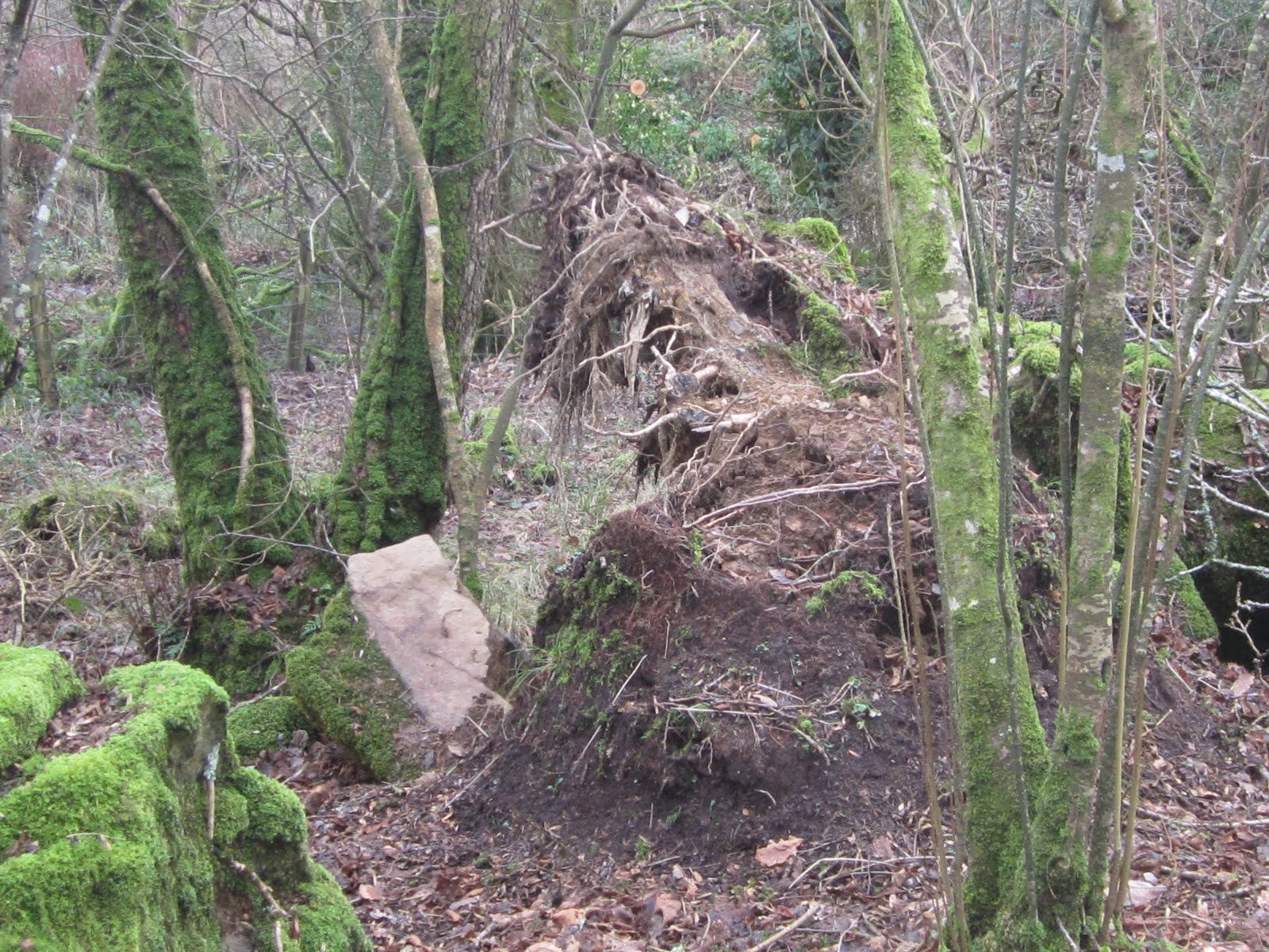
    The so-called slight mound on which the eastern recumbent tone is supposed to rest.  There are undulations -- up and down by around 10 cm -- but this degree of surface roughness is no greater than that seen right across the site.  The "slight mound" mentioned by Dyfed Archaeology was not beneath this stone at all, but beneath the western recumbent stone which we see in the distance. 


    Below I have copied in -- without any editing at all -- a commentary on MPP's talk to the National Park Archaeology Day on 17th Nov, written by a member of the audience.  I'm very grateful to him.

    --------------------------------------

    MPP led us through a rapid list of works in North Pembrokeshire: the Roman villa, Banc Ddu, and Dryslwyn  (should that be Pensarn?), before ending with Waun Mawn in a thrilling performance.

    The Waun Mawn segment started with a reference from the RCAHMW published in 1925, from a visit to the site on 18 June 1914. Within this is the sentence “ the surface of the common is much broken up by turf cutting, which has evidently obliterated traces of further stones of the circle, though it is probable that a further examination would reveal their positions.” It is curious that there is no apparent evidence of peat extraction over this area to be seen today. MPP didn’t dwell on this subject at the time, but drew attention to HH Thomas’s discoveries in the years afterwards and how we were lucky that they had not drawn the obvious conclusion that we have with this site.

    The significance of the digging on the moor did not become apparent until the end, when there was a question about this disappearance of the peat across the site. MPP said this was due to the digging mentioned in the Royal commission. I not sure there is any evidence of peat digging on the ridge, it could be possible down in the col to the south. As a reader of this blog, any digging at Waun Mawn immediately calls to mind the quarrying to south and northwest of the site. I suspect any peat here would have been extremely thin. MPP pointed out that the name means ‘peat moor’. The site is however close to the summit of the ridge, Cnwc y Hydd, or the Stag’s Knoll. How much of a tradition of peat or turf cutting was there on Preseli?

    Evidence for the stone circle is not strong. MPP marked up seven (I think) stone holes excavated. Two images of holes were shown, which were very convincing, although possibly small – it is difficult to tell in the lecture. We were shown a hole for the easternmost recumbent stone, which looked very dubious, but was obviously suffering from the effect of the weather. There may well be better evidence for this. I think this was the area of ground repaired by DAT in 2007.

    One interesting facet is that all the material in the holes has been sieved to retain any stone chips to be examined for petrological evidence. We may have the start of a Waun Mawn debitage thesis to match the one from Stonehenge.

    A range of large stone circles were outlined – Long Meg, Ring of Brodgar, Avebury, etc. Waun Mawn may be the third largest stone circle in the British Isles. While looking at these plans it was pointed out that some of them have gaps where stones should be, so why couldn’t Waun Mawn have equivalent gaps? I have gaps in my teeth, does that make me related to a certain film actress with gaps in her teeth?

    A disclosure during the talk is that the easternmost recumbent stone sits on a small mound, possibly make it more distinctive. The final slide shown had Waun Mawn superimposed on a drawing of Stonehenge phase 1. This gave the tantalising suggestion that from the centre of the supposed circle to this mound is an alignment to the Midsummer sunrise as happens at Stonehenge. The conclusion was that more digging was needed next year.

    There was no mention of where the stones went, or of other such similar matters. The audience were not looking for this aspect of the story. The site location slides happened to show Rhosyfelin, Carn Goedog and curiously, Cerrig y Marchogion along with the other sites, but they were only mentioned in passing, if at all. The synchronicity of events in radiocarbon years after 3000 BC was pointed out several times. There does seem to be a lot of activity around this time. It would be interesting to look at an analysis of radiocarbon dates of the region now that there are starting to be large numbers of them.

    Top marks for an interesting, well presented talk that ran through all the various sites and episodes in North Pembrokeshire. it will be very interesting to look at the detail in the specialist studies as they come out.

    ----------------------------------------------

    So yet another bravura performance from our old friend MPP, in front of an audience not particularly inclined to question anything.  One has to admire him for sheer brass.......... and so the hoax rolls on, getting ever more elaborate.

    Just a few points:

    1.  The comment from RCAHMW about peat cutting is, I think, nonsensical.  For a start, there are no traces of peat cutting here, because this is not a blanket bog area.  As NRW and the National Park have noted, this is an area of dry heath, and the soil horizon here is just the same as the soil horizon in many other parts of Preseli where the slope is quite steep and where there is good surface drainage.  I have published some images showing what it is like.  Secondly, if there had been peat cutting here (in other words, if the surface had been lowered), it would not have obliterated traces of any ancient stone circle -- it would have made them more obvious.  (There are some signs of peat cuttings on Preseli, especially near Foelcwmcerwyn -- and they are pretty obvious to anybody who walks over them.)  It may be that some of the quarrying traces on Waun Mawn and Cnwc yr Hydd were mistaken for peat cuttings, by people who did not examine them properly.

    2.  Agree that the evidence of stone sockets is not very strong.  In fact, it's downright lousy.

    3.  I imagine that as we speak, Rob Ixer will be ploughing through a bag of fragments collected from the site.  He will be searching desperately for fragments of foliated rhyolite and spotted dolerite -- both of which seemed to me -- on the basis of a superficial examination -- to be missing.

    4.  The significance of gaps in a stone circle?  What is the point MPP is trying to make here?  Again, we see the complete commitment to the idea that there was a circle here -- but if truth be told, there is no evidence and he's just joking......

    5.  Eastern recumbent stone on a small mound?  MPP has got this all wrong.  The recumbent stone recorded by Dyfed Archaeology as being on a slight mound was the western recumbent stone, not the eastern one. See this document:

    https://archwilio.org.uk/arch/query/page.php?watprn=DAT1567

    Groom,P , 2006 , Erosion Control Works at Waun Maun Standing Stones SAM Pe124

    That mound is in any case too small to be noticed by anybody who does not have the eye of faith.    There is no discernible mound at the position of the eastern recumbent stone.

    6.  Does the imaginary mound at Waun Mawn lie in exactly the compass position, from the proposed circle centre-point,  of the Midsummer sunrise on the Stonehenge horizon?  As we all know, the precise position of the midsummer sunrise (and any other sunrise, for that matter) varies from place to place, depending on the nature of the far horizon -- hills or plain, near or far........  To suggest that the builders of any stone circle at Waun Mawn knew the precise compass direction of the Stonehenge midsummer sunrise and then replicated it here by making a nice mound (which happens to be invisible today) strays so far into Robin Heath territory that I think we might be wise to forget about it.  The superimposing of one carefully drawn map on another carefully drawn map is as old as the hills, an old conjuring trick designed to cause gasps of delight in a gullible audience........

    7.  More digging needed next year?  OMG -- will this nonsense never stop?

    8.  Synchroneity of radiocarbon dates around 3,000 BC?  The coincidence of some dates around this time is completely meaningless without secure archaeological contexts, and these are completely lacking.  Also, we  have no control sites to work with -- so the density of dates at Rhosyfelin and Carn Goedog, and their distribution through time, may be no different from the situation pertaining at innumerable other sites in a landscape that was occupied in Neolithic and Bronze Age times.

    ---------------

    So there we are then.  We are not an inch further forward, except that the story has become ever more elaborate and has strayed even further into the world of fantasy.  As our intrepid reporter says, we look forward to the specialist studies more in hope than expectation.


    Monday 26 November 2018

    Fluvioglacial gravels exposed at Picton Point

    About a year ago I did a post on the glacial deposits around Picton Point, at the junction between the two Cleddau Rivers.  I was intrigued then and am even more intrigued now, having been there for another visit a couple of days ago.

    https://brian-mountainman.blogspot.com/2017/11/picton-point-old-glacial-deposits.html

    What was particularly interesting in 2017 was the high concentration of rounded and sub-rounded pebbles and cobbles on the foreshore to the west of the headland.  I assumed that there were fluvioglacial gravels in the neighbourhood, and this was confirmed by the geological map, as seen in the BGS online Geology Viewer.

    The junction of the two Cleddau Rivers at Picton Point.  Key to the sediments:  blue = till; pink = fluvioglacial gravels; yellow = silt and clay on the modern intertidal mudflats.


    Recently there has been a small landslip on the drift cliff about 50m west of the headland.  The cliff is about 15m high, and is much overgrown, but there is a new exposure that shows at least 2m of fluvioglacial gravels overlying brecciated or broken bedrock of shales and mudstones.  The lower metre or so of the gravels are iron-stained, but above that they appear fresh and uncemented.

     The lower part of the exposure.  At the base, unstained brecciated bedrock debris.  Above that, c 40 cm of iron-stained slope breccia grading up into c 1m of iron-stained fluvioglacial cobbles, 
    sands and gravels.

    The upper 1m of fluvioglacial materials, loose and unstained, incorporating a wide range of erratics.  Some of the cobbles are up to skull size.


    From a cursory examination, the erratics incorporate a wide range of dolerites, rhyolites and volcanic rocks similar to those found on Ramsey Island  and the western end of the Dewisland Peninsula.  This matches observations made on the foreshore last year.

    The deposits here may even be thicker than 2m -- the uppermost 5m of the cliff face has a gentle slope and is covered with thick vegetation.  The gravels are exposed at the surface in the fields inland of the cliff -- so the thickness may be c 7m.  Apart from the iron-staining at the base, these deposits look fresher and less weathered (one might even say less rotten) than the gravels at Llangolman:


    I have on many occasions discussed the spreads of till and fluvioglacial materials here and there on the south Pembrokeshire land surface, well to the south of the putative Devensian ice limit.  Here they look remarkably fresh, and because they are uncemented in an environment in which there is much free iron and manganese in the groundwater, I am tempted to say that they are Devensian in age.  But since the gravels are in a sheet extending up to 25m above the river level, that would mean that glacier ice must have been present across the whole of the landscape hereabouts. That in turn means that the ice extended at least 10 km inland from the shores of St Bride's Bay.  And that in turn suggests that the other glacial and fluvioglacial deposits in South Pembrokeshire might also be Devensian rather than Anglian or Wolstonian in age.  Very confusing.........

    One idea that has been discussed in the past is that the till deposits of South Pembrokeshire are of Anglian age, but that some of the fluvioglacial deposits were emplaced by heavily-charged meltwater rivers flowing southwards from the Devensian ice edge when ice wastage set in -- maybe after 20,000 years ago.  As noted elsewhere on this blog, it is reasonably proposed that  much of the water carried in the Gwaun-Jordanston  meltwater channel system was carried westwards and then southwards, flowing through the Trefgarn Gorge and then along the Western Cleddau valley past Haverfordwest and into the inner reaches of the Daugleddau.   There are large expanses of gravels in the valley, including some that look like gravel terraces which were partly removed as the river level dropped.  There is one such gravel terrace remnant at Cherry Grove in Haverfordwest, less than 100m from where I grew up.  

    But could the Picton Point gravels belong to this same system of Devensian gravel terraces?  I doubt that very much.  For a start, there do not seem to be long strips of gravels parallel with the course of the present river.  Second, the gravels here seem to be at too high an altitude.  And thirdly, there are far too many large -- skull-sized -- cobbles and boulders in the gravels, had they originated up to 20 km away in the western foothills of Preseli.  Contained clasts of this size must indicate an origin not far away -- and that means ice in the neighbourhood, within a km or two.

    I am very puzzled indeed.......

    =================================

    Note added 17 October 2019:  

    In the Geological Survey Haverfordwest Memoir, p 215, there is a reference to an interesting section on the shore of the Cleddau confluence, immediately to the east of Oxhouse Farm.  The location lies between Landshipping Ferry and Landshipping Quay.  Grid ref SN007113.  The section shows:

    Gravelly "boulder-clay" with igneous and other erratics
    Blue clay with plant remains and quartz pebbles -- related to the raised beach?
    Gravelly rubble becoming more angular downwards
    Rock platform?

    On the geological map an extensive spread of sands and gravels is shown as the surface deposit  in this area, so we can assume that it overlies the till.

    I need to go and take a look.......


    Thursday 22 November 2018

    Holgar and the bluestone voyage

    The 14-man crew at work (12 paddlers) on their epic voyage......

    The other evening I gave a talk at Verwig and was happy to meet Nick Newland, who was heavily involved in the building of the Holgar and in the voyage filmed in August 2012 by the Discovery TV Channel.  We had a chat about it, and Nick promised to send me the only material ever written about the boat and the voyage -- it was published in a boatbuilding magazine but has never, apparently, been put online.

    I wrote a previous report here:
    https://brian-mountainman.blogspot.com/2012/10/latest-discovery-channel-spectacular.html

    Much of the article is on the technical aspects of building Holgar, modelled quite closely on the Ferriby Bronze Age boat -- which must have been built at least a thousand years later than any boats that might have carried bluestones from Pembrokeshire to the other side of the Bristol Channel.

    Although the boatbuilders tried to be as authentic as possible in the boatbuilding methods used for this "lashed planking" vessel, there were all sorts of ways in which modern methods were substituted for ancient ones.  For a start, the planks were smooth and the cuts were as accurate as modern methods would allow -- within a millimetre or so.  The main planks running the full length of the boat (42 feet long)  were not made with rough oak or yew, but with three laminations of Douglas fir glued with epoxy resin.  Laminated strips were also cut on jigs and then glued up and used for the main frames.  Plywood formers were used, and modern fixes had to be used to achieve the bow and stern curves.  The overlapping joints between touching planks were cut with modern saws.   All of the holes for the lashings that held the planks together were made with modern drills.  The lashings were made from artificial fibres.   Screws were used to hold things together while glueing was in process, and then removed when the glue had set. Caulking was done with a natural moss, but it was inserted with a modern "caulking iron."  Many other technical details are given in the article, but the conclusion is inescapable that Holgar was vastly more sophisticated and more seaworthy than anything that could have been made in the Bronze Age, let alone the Neolithic.........  And if anybody tries to tell you that the Holgar project demonstrated that a boat like this could have carried one bluestone or lots of them, it did nothing of the sort.  It simply showed that this particular "imitation" boat, built with the use of a wide range of modern materials and methods, was capable of carrying a single bluestone monolith weighing about a tonne.


    The loading of the bluestone onto the boat was done quite smartly, involving a strange ramp-like structure made of logs lashed together and positioned between the tide marks at Gwbert in the Teifi Estuary.  The idea was that the stone would be put into position on a cradle on the beach at low water, lifted up with the aid of a "rolling log" on top of the structure, and then let down onto the bottom of the Holgar when it was manoevred into position on a rising tide.  Then the  ropes would all be released, and the boat with the stone on board would be allowed to float free.  In reality, on the day when the stone was supposed to be loaded, there was a Force 6 gale blowing, and a certain degree of technical interference was needed before the stone was properly positioned on the boat. The author of the article does not go into detail on that, but let's assume that the use of a JCB might have been deemed unsporting........


    Then we come to the voyage, which was flagged up at the time as demonstrating that a bluestone could be carried by a Neolithic boat all the way from the North Pembrokeshire coast to Stonehenge.    In reality, the Pembrokeshire coast was not tackled at all.  The boat with its bluestone on board was taken by road to Loughor  and then paddled most of the way from there to Burry Port -- with safety boats in attendance and with a tow being provided when the 12 paddlers found that they could make no headway against the tide.  Then the boat went back onto the lorry again for the journey to Barry, where it restarted its voyage to Cardiff Bay.  There was a further weather delay, and the boat was lifted out of the water for assorted repairs and for the replacement of caulking. The voyage was then resumed, and the crossing was made to Portishead on the other side of the Severn Estuary. Once again there was a tow, across the central part of the channel, so as to avoid any interference with commercial shipping..........  The paddlers then took the boat to Avonmouth and up the river on a flood tide to the Clifton Suspension Bridge and on into Bristol Harbour.  The final leg of the journey took the boat upriver, struggling against a powerful river in flood, as far as Keynsham.  There the journey was abandoned, and the Holgar let the river carry it back to Bristol Harbour.

    All in all, this was an interesting piece of experimental archaeology.  But there were so many modern technical fixes in the boatbuilding, and interventions (relating to weather and tides) during the "bluestone voyage" itself, that in my mind, just as in the "Millennium Stone" fiasco, the conclusion has to be that sea transport of large bluestones, even in the Bronze Age, would have been well nigh impossible.


    Postscript

    Here is a description of the building of the other "Ferriby replica" -- called "Morgawr" and built by a large team in Falmouth.  Here the methods used were more authentic, but not totally so -- and there were episodes during which the temptation to use modern technology proved too much............

    This boat was rather leaky and cumbersome, by the sound of it.   I think the conclusion must be that the Ferriby boats were probably used for sculling about in shallow coastal waters and maybe on rivers and lakes and in marshy areas, where the boats could be grounded quite easily for baling out and for repairs.

    https://onlinelibrary.wiley.com/doi/full/10.1111/1095-9270.12058

    Video

    https://www.youtube.com/watch?v=22chM3wYrk0