THE BOOK
Some of the ideas discussed in this blog are published in my new book called "The Stonehenge Bluestones" -- available by post and through good bookshops everywhere. Bad bookshops might not have it....
To order, click
HERE

Wednesday 31 October 2012

Seriously scary....


This is an image from the Extreme Ice web site, taken in 2006.  Click to enlarge.

It shows part of the Columbia Glacier in Alaska.  But the main thing of interest here is the glacial trimline -- the line dividing the dark coloured uplands with snowbanks from the lighter coloured slopes below.  It's remarkably sharp here.  Apparently it marks the position of the glacier surface in 1984 -- that's just 22 years before this photo was taken.  During that interval the glacier surface has been lowered by 400m -- the height of the Empire State Building.

Who says that climate change isn't happening....??

http://extremeicesurvey.org/photography/alaska/

The Stonehenge Stones

Distribution of rock types in the Stonehenge Layer -- or rather, in that part of the Stonehenge Layer recently investigated.  There is an extensive area still not studied -- and there is no knowing what might pop up during future investigations.......


One of my moles has sent me some info from a lecture which has already been presented twice (I think) and which will be given again within the next fortnight by one of the key geologists involved.  Since all of this is already in the public domain, I don't suppose I am breaching any confidences by putting some of it onto the blog.

The summary of recent research involves the following:

1.  There are 31 dolerite orthostats, of which 14 have been sampled in 1991 and 2008.  Some are standing stones and some are stumps.  Some are spotted and some are unspotted. (I am a bit mystified as to why the unspotted dolerites do not appear on the diagrams above -- stones 45 and 62 are made of unspotted dolerite.)

2.  There are five crystal vitric ash flow tuffs represented in the orthostat collection.  (Stones 40, 48, 46, 38, 52c.  (Four distinct types?)  There is not much debris to match these in the Stonehenge debitage, but similar fragments are found in the great cursus field.  Research is ongoing, but they may come from the Preseli area.

3.  There are four volcanic ashes -- stumps 32c, 33e, 33f, 41d.

4.  There is one calcareous volcanic ash stump -- number 40c

5.  There are 2 micaceous sandstone stumps -- numbered 40g and 42c.  (More info is eagerly awaited on these......)  There are also lumps of Lower Palaeozoic sandstone scatterd about in the debitage -- the largest lump weighing c 8.5 kgs.  From SW Wales?

6.  There is another calcareous sandstone -- the Altar Stone (stone 80).  sampled more than a hundred years ago, but not since.  Probably from the Senni Beds of Carmarthenshire or Powys? (Not from Milford Haven)  Interestingly, no debitage has been recognized in recent digs from this stone or from anything like it.

7.  In the debitage there are lots of fragments of volcanics with sub-planar cleavage -- matching the Rhosyfelin rocks?  The "rhyolite with fabric" is not all the same -- but most appears to be from the Pont Saeson area.  There are NO matching orthostats.

8.  There are also some basic tuffs in the collection of fragments from the debitage -- two lithologically different types.  From the Fishguard Volcanics?

9.  Other lithics in the stone collections from the debitage -- some stones are adventitious / introduced / modern, but some (eg haematite, greensand, Mesozoic sandstones and gabbros appear genuine, and need further research.

10.  In the course of the recent geological research, 6,368 rock samples have been examined and classified -- and organized by archaeological context.  the total weight of samples thus far is in excess of 70 kg.  Most fragments are very small, weighing on average about 11 grams.

11.  Almost half of the material in the debitage is sarsen -- I suppose we should not be surprised by that, but it would be good to know how many types of sarsen there are, and where they came from.....

12.  This recent research matches pretty well with what I said in my post dated 3 December 2011:
http://brian-mountainman.blogspot.co.uk/2011/12/bluestone-rock-types.html
I reckoned then that there are about 30 different rock types represented in the "bluestone assemblage" -- and unlike Rob, I give significance to the small bits as well as the orthostats, since I am interested in glacial and other processes and want to know where they came from and how they got here.

Tuesday 30 October 2012

Some decent glaciology on the telly at last?


Sorry about the fuzzy pic -- but look here for a splendid picture gallery.

http://www.bbc.co.uk/programmes/galleries/p010fw9c

Better still, watch BBC2 tonight at 9 pm -- looks as if this will be interesting...

Operation Iceberg, with Alun Hubbard doing very silly things......... by the way, Alun is one of the guys who has been doing the modelling at Aberystwyth for the oscillations of the Irish Sea Glacier.

About time too for a programme like this -- the BBC has been far too slow at reacting to the fact that glaciers don't just tell us a lot about how the natural world works, but also about what is happening right now to the global climate.  Please watch!

Postscript 10.30 pm:  I was pretty pleased with that.  Some wonderful footage, and a fair amount of decent glaciology too........ not nearly as much dumbing down as one normally sees on "popular science" programmes.

Have a look here too:

http://www.aber.ac.uk/greenland/index.shtml


Sunday 28 October 2012

Another review for The Bluestone Enigma


 Since I seem to spend so much time giving puffs for other people's books, here is one for my own book, for a change.....  and I promise I have no idea who Dr K James might be!

The Bluestone Enigma: Stonehenge, Preseli and the Ice Age 

by Dr Brian John.

17 Sept 2012

Dr. K. James

This is a fascinating and thought-provoking book. I bought it for a little light reading whilst on holiday in Pembrokeshire, intending to dip into just a couple of chapters per day. But I found it so engrossing that I ended up reading it cover-to-cover in one sitting. I have since read it on two further occasions, and each time I have been impressed by the thoroughness of the author's argument.

With regard to the book's content, I wouldn't add much to the previous reviews except to say that the text is clear, accessible and well structured; and it appears to have been researched rigorously.

I am not a geologist or archaeologist, so I have no particular axe to grind, but I have to say that I found Dr John's case for glacial transport very convincing indeed.

The opposing view - that humans dragged, floated and levered the bluestones all the way from Preseli - obviously makes a good story for the media. And it's not surprising that millions of people take it on trust when every other book, magazine article and TV documentary on Stonehenge repeats the human transport theory as though it were established fact. But, judging by Dr John's account, there is obviously significant scope for doubt; and in view of the petrographic, glacial and other evidence discussed it seems astounding that some archaeologists and other authorities continue to adhere so rigidly to the human transport theory.

I hope that Dr John's work will help to redress the balance. It deserves to be widely read - both by those in the field and by the general public. This is the most compelling book I have encountered in a long time and I would highly recommend it.

5.0 out of 5 stars 

More about Bluestone magic


I just came across a reference to this book, which apparently came out about a year ago without me noticing it........
Preseli Bluestone: Healing Stone of the Ancestors 
by Simon Lilly and Sue Lilly
116 pages, Tree Seer Publications (30 Nov 2011) Price £9.95
ISBN-13: 978-1905454082

Here is the publisher's blurb, in case  anybody is interested.

Stonehenge is one of the most iconic and evocative symbols of Britain's past. At its heart is a mysterious rock, Preseli bluestone, which was transported from West Wales and placed in the centre of this important site. Up to eighty monoliths of bluestone may have been present at some periods of Stonehenge's development, arranged and rearranged into different shapes and patterns. It now looks as though the giant sarsen stones were only a framework to hold and protect these centrally important bluestones. In this book we examine the reasons why stones from the remote upland of Mynydd Preseli in Pembrokeshire might have captured the imagination of our ancestors. Clues can be found in archaeology, in literature and myth, and in the two very different landscapes of Preseli and Stonehenge. Most of all, our experience of working with the healing and spiritual properties of Preseli bluestone suggests to us that it was these qualities that made the stone so special. Not only can bluestone be helpful in a wide range of healing situations, but it can also open our awareness to other levels of reality and broaden our personal understanding of time and space. Visionaries and alternative researchers have often seen the ancient, sacred sites of the distant past as part of an integrated, vast system of energy pathways that encompass the planet. This new research suggests that Preseli bluestone has an important role to play in understanding the subtle structures of the Earth and in bringing balance and harmony once more. Presented here for the first time, and central to the book, is a unique collection of more than twenty five original layouts and techniques that have been designed to help you to explore the potential of Preseli bluestone, both working by yourself and within groups.

 This raises quite interesting issues about the attribution of special or sacred qualities to bits of stone or other inanimate objects -- such as the relics which caused such economic and psychological mayhem in the Middle Ages and also much more recently. The Roman Catholic Church seems to have been particularly prone to this sort of thing.   Are there always some people who WANT to find healing or mystical qualities in things which the rest of us find rather mundane?  Are such people in possession of insights or spiritual qualities that the rest of us do not have?  Or are they just slightly dotty but otherwise harmless?    Hmmm -- I think we have been here before......


Friday 26 October 2012

Are there more "periglacial stripes" at Stonehenge?


I was struck when I came across this "micro-morphology" map in the 2010 Pearson/Field report (published by EH) by the realization  that the old monument is located on the edge of a very gentle spur.  It's not obviously apparent when you are walking about on the site, but these contours -- at intervals of just 25 cm -- show it clearly.

The periglacial stripes which MPP has written about quite extensively are in the avenue, which runs away from the embankment and ditch towards the NE.  The stripes, so we are told, run in exactly the right direction, exactly parallel with the edges of the avenue and just right for something astronomically highly auspicious.  Hey presto!  So that is why, in the view of MPP, Stonehenge is where it is -- because the periglacial stripes were aligned in the right direction.

From a geomorphological perspective, the stripes do indeed run in the expected direction -- straight down the rather gentle slope.  Just in that one location.   But what about everywhere else on the map shown above?  If there are stripes in the chalk surface over a wider area, as we might expect, we can speculate that they should have a more or less radiating pattern, always running perpendicular to the contours.  So to the north of the Avenue, they would be running NNE, and to the south of the Avenue ENE and then, further round, more or less E-W, and then further south still, ESE and then SE and then SSE.  If the stripes were visible at the time when Neolithic people were thinking about building the first earthworks at Stonehenge, ALL of these stripes, with many different compass orientations, will have been visible to the naked eye.

That particular MPP theory about the location of Stonehenge looks increasingly dodgy -- and clearly there is a need for more work on this interesting little periglacial problem.

Thursday 25 October 2012

More missing Stonehenge stones

 Some of the stones from the collection.  The row of stones to the left of the number 5 are labelled as "diabase" -- but they all look different.  It looks to me as if there are at least 10 different rock types represented here........ not counting the flint flakes in the tin.  Some of the bits to the right of the tin may be the rhyolites referred to in the notes.

Many thanks to Pete Glastonbury for bringing our attention to yet another batch of material from Stonehenge that has gone missing.  Apparently it was sold off on Ebay about 6 years ago -- and goodness knows where it is now.......

Not all of the material in the collection came from Stonehenge, but there are written notes which describe the most interesting finds.  Extracts:

The gentleman in question (an archaeologist) assisted Col Hawley for a short time in 1921 with excavations around the inner and outer circles of Stonehange, a project which took Hawley a number of years
As a thankyou for his assistance Col Hawley gave this gentleman a number of specimens of items he had uncovered

The collection, which weighs around 8 kilos comes with a letter / statement handwritten by the previous owner which reads as follows:-


Stonehenge September 1921 Brockham End Nr Bath Specimens given to me today 13th September 1921 at Stonehenge by Col Hawley who is excavating the circular foss outside the rampart. While working with him this afternoon John found a very large vertebrae and found a large reindeer antler.

A. Fragments of Rhyolite B. Fragments of Diabase C. Fragments of sarsen stone ( hard) D. Fragments f shaley slate E. Fragments of sarsen stone (soft) F. Flint flakes from the foss

C&E and also quartzite pounding stones are relics of a xxxxxx bed of bagshot sand and are a land formation sometimes showing flaws from roots of palm trees E is the same as C with the absence of xxxxx xxxxx

The flint flakes are abundant and are surely the remnants knocked off in making flint tools

The sarsen stone may have been local when Stonehenge was built though not now found in the immediate ring. They form the largest standing stone and lintel and were also used for packing the bases of the standing stones underground

Rhyolite and diabase are two of the five kinds of stone used in the inner ring and inner horsehoe of smaller standing stones. All of these have been brought a long distance and the diabase has recently been identified as coming from Pembrokeshire

Shale slate is also a xxxx stone having less durable characters possibly they were originally standing stones.


Group of stones and pieces of stone Some labelled Stonehenge 1921 with letters that correspond to description on statement above.


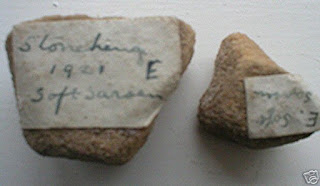
Two lumps of rock with rounded edges -- labelled as "soft sarsen"


This is an intriguing group of fragments, which seems to include some pottery.  But some of the pieces look rather like the shales and mudstones which I find all over the place in North Pembrokeshire.......

Another interesting batch.  Again, some pottery pieces, but including some bits of shale and mudstone.  (The notes refer to "shaley slate" -- but these don't look like metamorphics......

Wednesday 24 October 2012

Newall's ignimbrite boulder


 Col Hawley and his team in 1919.  A nice pic from the EH collection:
http://www.english-heritage.org.uk/daysout/properties/stonehenge/history-and-research/research/1-the-first-excavations/


I have come across a number of references to a strange boulder of Ordovician ignimbrite which was found during Col Hawley's excavations at Stonehenge in the 1920's, together with "other striated erratics."  These were assumed to be metamorphic rocks of Welsh origin.  Apparently some of the archaeologists at the time of excavation thought the stones were glacially derived, although Hawley would have none of it.  According to legend, the stones were shaped by ice, faceted, and some had striations on them.  James Scourse discusses this on pp 285 and 287 of his chapter in the "science and Stonehenge" book, and tends to dismiss the evidence as unreliable.  But I'm not so sure, and tend to be more trusting of the word of Newall and Kellaway....... not to mention the apparent agreement of Dale and Engleheart with reference to a glacial origin for this material. 

Newall kept the "boulder" and other material for almost half a century, and then passed it on to Geoffrey Kellaway around 1969-71.  Kellaway took photos of the boulder and published them here in 1991: "The older Plio-Pleistocene glaciations of the region around Bath."  In Kellaway, GA (ed) Hot Springs of Bath, pp 243-41.  I have not seen this article or the photos, but Scourse describes the boulder in question as a "sub-angular to sub-rounded, faceted and bleached clast".  Scourse also says that the signs of striae are not clear enough to be convincing.

Thorpe et al tried to trace this boulder, but could not find it.  So what happened to this little Newall collection?  Is it still in the possession of Geoffrey Kellaway, or has it ended up somewhere else?

All info gratefully received.......


Tuesday 23 October 2012

Thor's Hammer and the Stonehenge images...


From Chris:  This amulet was found in Norway, at Fitjar in Hordeland.  Could it be that the images relate to victories by a Scandinavian war band in the dark ages?

Chris remarks that this image bears a striking resemblance to the images revealed by laser scanning on  the surface of some sarsen stones at Stonehenge...


Personally, I'm not all that convinced....

The Stonehenge Mound

I have been looking again at the excellent Field and Pearson report from 2012: Stonehenge, Amesbury, Wilts Archaeological Survey Report (EH Res Dept Report 109-2010.)  Easily downloadable from the web.  The image above is one of more than 400 available from the Wiltshire Heritage Museum:  http://bitly.com/QErQwC.  The EH Report is available here:  http://research.english-heritage.org.uk/report/?14951

I was struck yet again by how measured and responsible the whole study is, compared to some of the wilder things that have appeared in print over the past few years.  Again, I was reminded that some people in quite responsible positions within EH incline towards the view that the sarsens (and maybe the bluestones too) were all collected up from within a limited area around Stonehenge, and that the stone monument was probably never completed (as the believers in the "immaculate" Stonehenge would have us believe).............  It's good to know that there are some archaeologists around with whom I share common ground.

What took my eye on my latest reading was the section on the Stonehenge Mound -- seen quite clearly on the 1873 painting above, and on the detailed contour map.  Note that the mound is very subtle -- the contour interval is just 25 cm -- but Field and Pearson suggest that it might have been more prominent at one time.  They discuss at some length the proposition that the mound is man-made from debris thrown up during the various construction phases -- but there is also the possibility that it is a natural feature, now less prominent than it might have been when the site was first selected for assorted building projects by the inhabitants of Salisbury Plain.

I'd like more evidence.  Do we know what the mound is made of?  Do we know how deep the sediments are from surface down to chalk bedrock?  And -- whisper this very quietly -- could it even be a last remnant of a mound of glacial sediment?  A moraine, in short........


The Megalithic Empire


I was sent a copy of this sombre-looking book for review, so I suppose I'd better oblige........

It's a wildly eccentric tome, in parts deadly dull, in parts quite entertaining, with the central thesis that there was once something called "Megalithia" or the Megalithic Empire which controlled and orchestrated everything like some gigantic secret society or underground subversive organization -- infiltrating into all aspects of life from the Neolithic period up to the present day.  Like many other books, the belief underpinning this one is that there was a sort of Ancient Wisdom which is still there if we want to look for it in the landscape, in our language and folk traditions, and even in the domestication of wild animals.  Another part of the central thesis is that because archaeologists argue about all sorts of things, that just goes to show that they know nothing, and that somebody like the authors (Harper and Vered) must come along and tell the truth. Sounds familiar?

So this book is a polemic rather than a careful examination of evidence.  In fact, the authors seem to have so little respect for evidence on the ground that they cannot even be bothered to cite proper case studies or give references to support their arguments.  They simply state everything as if they are self-evidently in possession of the truth, and as if all other hypotheses coming from many decades of careful archaeological research are self-evidently nonsensical.  Such confidence might be a fine thing if the authors could demonstrate some knowledge of the things they are talking about, but the book is littered with evidence which goes to show that they do not really know their territory and that their grasp of concepts (about landscape evolution, for example) is seriously inadequate.  Some decent refereeing or editing might have helped..........

There are three parts to the book.  In the first part the authors propose the hypothesis that stone circles and ovals were made as direction-finding structures which could be used by reference to a simple set of rules by those intent in making long-distance cross-country journeys.  They could be used rather like a compass or a clock face to guide the traveller towards and along long-distance trackways akin to ley lines.  The authors say that many landscape features were specifically fashioned by the Megalithic Empire bosses (whoever they were) to assist in the process of navigation.  The middle part of the book (which is rather turgid) relates to folk beliefs and suggests that there are many survivals of Megalithia to this day.  And the final part of the book suggests that these mysterious ancestors not only domesticated birds and animals but taught them to become a part of the communication system (because there was no written language) and also a part of the system for travelling about in droving groups or as trading groups with pack animals.  In a truly wonderful section, the authors suggest that jackdaws were trained to stand at crossroads where they could give instructions to travellers who might be looking a bit lost...............

On the website that goes with the book, they say "everyone can agree that The Megalithic Empire is complete tosh........"  I think I would agree with that.  Now then, excuse me while I go and lie in a darkened room for a while.........

http://www.themegalithicempire.com/


Monday 22 October 2012

200,000 hits -- and counting

I noticed the other day that we have gone through the 200,000 barrier on this blog.  There have been more than 200,000 hits or page views, and more than 100,000 visits to the site. Some visits will be very ephemeral, but many visitors are looking at two pages or more -- which indicates that some serious research or reference work is going on.  There seem to be more than 400 page views on most days. 

I'll continue to provide reliable and interesting material on Stonehenge and the bluestones, and on the processes (both natural and man-made) which might have been involved in the creation of that iconic structure.  A special "thank you" to all those who contribute regularly in a respectful and stimulating fashion -- I hope we all gain from the exchange of ideas, and I hope that our exchanges also give non-contributors in the fields of archaeology and the earth sciences something to think about.  Enjoy!!

Saturday 20 October 2012

Trefael -- a very foreign erratic?

There are some excellent photos  on the Welsh Rock Art Organization site, together with stunning pics.  Some of them have been taken from an "aerial cam" from vertically above the site.  There has been a lot going on there over the past three seasons -- with George Nash and various others looking at not just the cupmarks but a lot else besides.  The latest developments are that the "standing stone" has been reclassified as the capstone of a very early (5500 BP) portal dolmen; that there seems to have been a very long history of use of this site; that there is a burial here, next to the dolmen itself, maybe dating from the Bronze Age (bones have been collected and sent off for dating); and that there may even be traces of Mesolithic use of the site.

http://www.rock-art-in-wales.co.uk/database/welsh-rock-art-trefeol-excavation.html

From my point of view, the most interesting thing about Trefael is the very strange shape of this cup-marked stone.  Doesn't look very local to me -- and indeed from its shape it looks as if it might be rather far-travelled.  It is also rather badly fractured - see the top photo.  Must get over there and have a serious look at it.  Has the rock come from the Fishguard Volcanics?  My guess from the high degree of erosion on the stone is to say "probably not....."


Friday 19 October 2012

Ancient Wiltshire Exhibition -- Pete's pics


I'm happy to put up some info about this exhibition, featuring some of Pete's photos -- running until the end of the year in Devizes.

EXHIBITION: Ancient Wiltshire: Photographs by Pete Glastonbury

Opens, 28 October, 2012
Wiltshire Heritage Museum, Devizes

Stunning photographs capturing the mystery of Wiltshire's ancient monuments and landscapes. Opens 28 October 2012.

The exhibition features Pete's knowledge of the monuments of the Stonehenge and Avebury World Heritage Site, combined with his deep interest in astronomy and space science.
The exhibition also commemorates the 200th anniversary of the publication of the first true archaeological publication.
About the artist:
Pete Glastonbury grew up in Somerset, and initially studied at Technical College before working for Mercedes Benz. After a short spell studying Art and Design, Pete began, working with disadvantaged teenagers in Kent before moving to Brighton, where he met his wife, Alison.
Pete has been a photographer for 25 years, starting out in his mid-twenties, setting up a studio in Brixham, where customers could pose in a variety of costumes for portraits taken on an old-fashioned wooden 10” x 8” plate camera. Today he uses a variety of Pentax digital cameras and lenses. Digital photography has been a godsend as it means thousands of photographs can be taken - though Pete does miss using a darkroom.
The photographs Pete enjoys taking the most are landscapes. With these he excels in technique and style, capturing the natural beauty of the surroundings like no other. Sometimes many hours, or even days, are taken to pick the right moment for each individual photograph. Coming a close second to landscape photography is astronomical photography. He has also taken pictures of his family throughout their lives - meaning he has a very comprehensive family album.
Pete’s love of archaeology is almost on a par with his love of photography. He has devoted many years to following archaeologists on their digs around Avebury, Stonehenge and other similar areas, documenting the events and discoveries pictorially. Because of the tremendous amount of time and energy studying and researching these sites Pete can, in general, tell you just about anything you want to know when it comes to Stonehenge, Avebury or similar sites.
Pete’s work has been widely published in a variety of media. Newspapers and magazines include the Wiltshire Archaeological and Natural History Magazine, PAST (the newsletter of the prehistoric society), 3rd Stone, Time and Mind, Fortean Times, British Archaeology, Current Archaeology, Kindred Spirit and many in-house magazines. In 2003 he was voted Megalithic Digital Photographer of the year in Digital Photography magazine and in 2010 he achieved a childhood dream by having a photo published in the Beano! Many books benefit from his work, including The Avebury Residents’ Pack, The Story of Silbury Hill (Jim Leary and Dave Field), Stonehenge – Earth and Sky (Gerald S. Hawkins & Hubert Allen), A Picture of Britain (David Dimbleby), Researching Paganisms (Blain, Ezzy, Harvey) and Stonehenge – Celebration and Subversion (Andy Worthington). On television his work is regularly used by BBC Points West news and weather, and occasionally HTV news, CBS and Al Jazeera news.
After taking part in the Moore Marathon with his daughter Sammy (who was 12 years old at the time) seven photographs were chosen for broadcast on the prestigious Sky at Night BBC programme. As an amateur astronomer Pete’s work appears on some of the finest astronomical websites including: The World at Night, Spaceweather and NASA. His internal panoramic photograph of Stonehenge was used in the software package Starry Night Pro which allows users to view the stars from inside the stones at any time in history. His photographs have also been used by websites and blogs such as Clonehenge, and by such notables as Lord Avebury (Eric Lubbock) and astronomer/musician, Brian May. Being English, Pete also keeps a keen eye on the weather and has photographs of odd weather phenomenon on websites such as: The Cloud Appreciation Society and Atmospheric Optics.
Having lived all over the West Country Pete now lives in Devizes. He has three children, two of whom are adults with children of their own, giving him three grandchildren. His wife tells him he is very happily married!

Cost:   Usual admission charges apply

Thursday 18 October 2012

Perched residual, Brittany


Since we have been talking about perched blocks lately, here is one from the north coast of Brittany, west of Roscoff.  Click to enlarge -- see the person for scale.  we see a cluster of perched blocks here -- the biggest is the one on the right.  Glaciation has nothing to do with any of this -- over many millions of years the granite has been weathered away in those areas where jointing is closest, and where rotting has been able to make most progress -- and the residuals are simply the bits of resistant or coherent granite that have been left behind.  They have been "let down" onto the current land surface bit by bit, probably in some sort of "jerky" motion, involving long periods of stability and then short episodes of sliding or settling.

I wonder how many of the big menhirs of Brittany have simply been "let down" in this way?  This is the mechanism most frequently cited in the case of the stones at Carnac.

This is the sort of mechanism also assumed to have operated on Salisbury Plain with respect to the sarsen stones -- which are essentially concreted residuals derived from an overlying sandstone layer that has been for the most part removed over millions of years.  As I have argued many times on this blog, they didn't need to come from Marlborough Downs -- the current thinking seems to be that they were all scattered about in the Stonehenge area, and did not need to be collected up from any great distance away.

The Daro-Daro from Nias


Thanks to Geo for drawing our attention to this fantastic photo.  Apparently it's from the island of Nias, off the coast of Sumatra.  It appears to have been taken in 1915, during the transport of a large "daro-daro" stone, designated to be used as a justice table.  So clearly there was high status and motivation involved here.  I found a few more bits of interest, on the web:


Daro-daro -- flat stone used as a table -- for the administration of justice

Big stones (megaliths), some nicely decorated, were a part of the culture of the island of Nias off the western coast of Sumatra, Indonesia. There were big stone statues, stone seats for the chieftains and stone tables where justice was done. There were also big stones needed to commemorate of important deceased people. When such a stone was erected, a ritual feast was to be given. All this to enable a nobleman to join his godly ancestors in the afterlife. On the photo such a stone is hauled upwards. The story has it that it took 525 people three days to erect this stone in the village of Bawemataloeo. (P. Boomgaard, 2001)

Stone and wood are two part of material that have significant meaning for Nias culture. Nias Island is famous with megalithic tradition[14]. According to research result form Medan Archeological office, there are some area in Nias that still have megalithic tradition: Subdistrict Sirombu (Sisabandrao village); Subdistric Mandrehe (Sisarahili village); Subdistrict Teluk Dalam (Bawomatoluo , Orahili Fau, Hilifalawu, Hilisimaetano); Subdistrict Lolowau (Olayama, Bawe Hesi, Ehosakhozi); Subdistrict Gomo (Tundrumbaho). The relic of megalithic tradition in Nias have connection not only with the soul of ancestor but also with the efforts to elevate the prestige and social[15].
Hombo Batu or stone jump is the one of tradition of Nias people that still exist until now. Usually, the people who will become to adult (men) must able to pass when jump the stone. The hight of stone from the ground around 2 – 2.5 meter. We still can find many relic of Nias people that made from stone : like menhir, statue, daro-daro (table from stone).

Wednesday 17 October 2012

The "No Purpose" Hypothesis


Above, Carn Meini, in the open uplands, starting point for the CM team.  Below, Rhosyfelin, in the wooded lowlands -- starting point for the RYF team.   No contest really......


I was struck by this statement from Chris the other day:  "Colin Richards explained to me that cultures which move stones within living memory can assign different meanings to stones depending whether they are still attached, just quarried, or being moved.  He also said that the stones can lose an important meaning when they have arrived - the act of moving the stones being the centre of the ritual."  I'm not having a go at Chris here -- he was after all just reporting, not pontificating -- but the idea put forward by Colin Richards is really rather entertaining............

What he seems to be saying is that you do not need to have a purpose or an objective, in deciding to move one stone -- or maybe 80 -- from West Wales to Stonehenge.  The significance is all in the act of moving the stones.  If you are one of the stone movers, you need to know nothing of political alliances or economic motives or grand designs -- your satisfaction comes from the jolly good exercise and use of interesting haulage techniques that might be employed by you and your mates.  In other words, the stone moving expeditions are rather like team sports, in which you bond closely with your colleagues in pursuit of some utterly frivolous and useless goal, just in order to show that you are up to the task, and maybe to show that you are smarter than some other team who happen to be moving some other stones from elsewhere.  So maybe we had the Rhosyfelin stone hauling team versus the Carn Meini stone hauling team?  Maybe there was a handicap system in force, since the Rhosyfelin team had to cope with all those extra nasty river valleys and steep slopes, while the Carn Meini lot just had to go -- for the most part -- downhill?   And the result?  Carn Meini team -- 22 stones, Rhosyfelin team, 1?  A very one-sided contest, that one......

So now we have another "purpose" for Stonehenge.  It was not a Neolithic hospital, or a shrine to the dead ancestors, or a grain store, or an astronomical obervatory, or an art gallery, or a music hall, but it was a sporting arena, where strong and healthy chaps indulged in harmless exercise, just for the praise of their fellow men and the admiration of the women folk.  Were gold medals awarded to the winners, or just bronze ones?

Of course, I have argued earlier on this blog -- quite seriously -- that Stonehenge was a folly, erected in some grand exercise in self-glorification by a crazed Neolithic chieftain.  Sporting activities are not quite so stupid as building follies, but they come close, and as an enthusiastic sportsman myself in my youth,  I have to say that the idea that stone-hauling was a Neolithic sport (like curling or tossing the caber or putting the shot) should not be scoffed at by people who do not understand the competitive and sporting spirit.

So that's all sorted then.

The Carn Arthur Boulder


This is one of Ceridwen's excellent photos, added here at Chris's instigation.  Chris seems to think that we should delve into the mysteries of "stones that look like animals" and so forth -- not sure I want to go there.  But fine -- if you want to think this stone looks like an afanc or a dragon coming out of an egg, go ahead.  Mind you, from all other directions it looks like -- hmmm, a large stone.

Reminds me of all that fun and games a while ago about that stone hedgehog -- or was it a little piggy...?  Mind you, this one is a great deal more impressive -- although, as Geo says, it's pretty pathetic alongside some of the other perched blocks that we find on the granite coasts of Brittany and elsewhere.

Tuesday 16 October 2012

Carn Arthur and the mighty boulder

 Two nice photos of the mighty boulder perched on top of Carn Arthur, not far from Carn Meini at the eastern end of Preseli.  It's not actually a rocking boulder, although it is pretty precarious.......

It all goes to show what a mighty fellow old King Arthur was -- for according to legend he was the one who put it there, by throwing it over the mountain from the other side, somewhere near Carn Alw.    Alternatively, if you want to be prosaic, a glacier might have done it.......

Friday 12 October 2012

Stonehenge -- what the laser survey has revealed


Courtesy British Archaeology -- this is the plan that's doing the rounds of the web sites.  Very interesting -- it summarises what the new laser survey has revealed.

Wednesday 10 October 2012

A Short History of the Bluestone Wars

Last evening I earned a free supper (not to be sniffed at in these straightened times) by giving a talk to the Preslei Tourist Association.  Seemed to go down well enough, although of course all the tourist operators LOVE the heroic human transport myth, and HATE the idea of somebody coming along and undoing all their careful sales pitches about the mysitcal wonders of the Preseli Hills area.  Heroic Neolithic tribesmen bring money into the local economy, as the Stonehenge management knows full well.......

Anyway, I had a bit of fun talking about the GW/TD tribe and the MPP tribe, and their various territories, magnanimous benefactors and TV spectaculars.   Mention was made of sacred springs and petrified ancestors.  That's all I am prepared to give away for the moment.....  actually you have heard most of it here before.

Latest Discovery Channel spectacular


Thanks to Robin Heath for these photos -- published in various places, including here:
http://blog.stonehenge-stone-circle.co.uk/category/megalith/

There is also an article with the following title:

Moving the Stonehenge Bluestones; at last a successful method is demonstrated!


I won't reprint the article, since it's full of inaccuracies.  No matter -- the main point  is that the Discovery Channel team from the US of A was determined to get their nice little project off the ground, and set up this experiment at Gwbert, near Cardigan.  The location was probably chosen in deference to Mike Parker Pearson, who now thinks that the Stonehenge bluestones were taken out to sea from the North Pembrokeshore coast, and not from Milford Haven.  (The Discovery Channel producer made contact with me some months ago, but when I tried to explain to her how ice worked, she quickly lost interest.  Glaciers are clearly not sexy enough for an American TV audience. A pity -- I was looking forward to a trip to Greenland with a film crew........)

You can see the method here -- a big wooden frame built between HWM and LWM in a tidal estuary,  and a system of rolling logs and ropes to lift the stone on its cradle and to move it along on the raised "rails".  Then as the tide rises the boat is floated in beneath the stone and its cradle, and when the cradle fits snugly in the bottom of the boat, you release the ropes.  Then, with the cradle and stone fitted snugly into the bottom of the boat, the boat floats free and goes zapping off to the mouth of the River Avon, or wherever.......

This is not the first time we have boats, stones, cradles and tides invoked as a means of lifting and shifting bluestones.  But this one does have the merit of being quite simple and straightforward.

But now to the problems.  First, the Ferriby boat is far too late -- the three Ferriby boats are dated to c 2,000 BC or younger, and they are always thought of as Bronze Age.  If the bluestones were moved by human beings from Wales, they must have been moved around 4,500 BC, if MPP is to be believed.  that's 2,500 years before the Ferriby boats were built.  It's easy to say, ah yes,  boats with sewn planking COULD have been built much earlier than the ones at Ferriby -- but I and many others have serious doubts about that that was possible without metal tools.  Second, I still have problems with the use of long and strong ropes -- such as those used on the famous Millennium Pull in the year 2000, and the ones used here in this experiment.  Did our Neolithic ancestors have the technology to make ropes like this?  I have never seen any evidence that they did..........

But what the hell.  These guys have had a lot of fun on this experiment, and the TV programme will probably give an hour of innocent escapist fun to TV viewers worldwide when it is shown.


Stonehenge was a huge prehistoric art gallery?


The daggers found on the face of sarsen stone 4

I thought the silly season was over -- but I was wrong. David Keys (in the Independent) has a bit of fun with this one -- but his tone appears deadly serious.  Surely he must be joking?  So the old ruin has been a concert hall, a temple, an observatory, and a lot more besides -- and now an art gallery.  Whatever next?


Revealed: Early Bronze Age carvings suggest Stonehenge was a huge prehistoric art gallery

A detailed laser-scan survey of the entire monument has discovered 72 previously unknown Early Bronze Age carvings chipped into five of the giant stones.

David Keys
http://www.independent.co.uk/news/science/archaeology/revealed-early-bronze-age-carvings-suggest-stonehenge-was-a-huge-prehistoric-art-gallery-8202812.html

Tuesday 09 October 2012

Tuesday 9 October 2012

Stump 32e again....


 I notice that the mistake about stump 32e is repeated in the new report on the laser survey of Stonehenge.  On page 41 the text says "........rhyolite stump 32e has been proposed as the possible origin for much of the banded rhyolite debitage scattered throughout the Stonehenge landscape (Ixer and Bevins, 2011, 2011a, 2011b; Bevins et al 2011; 2012).

As we can see above, stump 32e (closest to the standing stone numbered 33) looks nothing like a banded flaky rhyolite.  The one the authors probably meant to refer to was 32d -- in the middle of the group of 3 stumps.  You can see the location on the plan below.


The Stonehenge laser scans

Thanks to Tony for drawing this to my attention.  There have been a number of reports of the recent laser work at Stonehenge -- although for the most part the conclusions do not seem to move things along all that much.  The idea that most dressing was done on the "visible" sides of the sarsens is surely a very old one......

The project seems to have been designed to generate powerful images to be used in future interpretations of the site for the sake of visitors. Fair enough.

I'm quite intrigued that Susan Greaney says: "I think we can say now that the monument certainly was finished – but where the stone went is still a puzzle." Evidence please, Susan?
====================
Stonehenge up close: digital laser scan reveals secrets of the past

Most detailed analysis yet of prehistoric stone circle shows how masons spent more time making key areas look the best

Maev Kennedy
The Guardian, Tuesday 9 October 2012


Like any corner-cutting modern builder, the ancient stonemasons who built Stonehenge lavished the most work and best materials where they would be first seen –shining in the last light of the setting winter solstice sun, or at dawn on the longest day.

The first complete 3D laser scan of the stone circle has also revealed tool marks made 4,500 years ago, scores of little axehead graffiti added when the enormous slabs were already 1,000 years old, and damage and graffiti contributed by Georgian and Victorian visitors.

The survey, carried out for English Heritage, exposes numerous details now invisible to the naked eye and will be used in displays for the long-awaited new visitor centre, due to open late next year. It shows the stones in unprecedented precision, from the double-decker bus height sarsens from Salisbury Plain that give the monument its unmistakable profile, to the smaller bluestones brought from west Wales by means still hotly debated, and the stumps of stones that have almost been destroyed.

It also confirms the importance of the prehistoric monument's alignment on the winter and summer solstice. The largest, most uniform and most imposing stones, carefully shaped and dressed through hundreds of hours of work with stone hammers, were set where they would be seen first by people approaching the monument from north-east along the Avenue, a processional way that would have been particularly spectacular at the midwinter sunset.

In an epic piece of work, the stones facing in that direction were laboriously shaped to appear straight and regular, their original rough brown surfaces hammered away, or pick-dressed, to expose the lighter inner layer of stone, which when newly worked would have shone in the sunlight. The gigantic lintels that bridge the uprights were also elaborately worked to even their size and height.

In contrast, on the opposite side of the circle the builders only bothered to pick-dress the inner faces of the surviving uprights. The backs, they clearly reckoned, would never be studied in detail.

Clive Ruggles, emeritus professor of archaeoastronomy at the University of Leicester, said it was already clear that Stonehenge was one of the earliest examples of a monument aligned on the winter and summer solstices.

"Now we can see how the utmost care and attention was devoted to ensuring the pristine appearance of Stonehenge for those completing their final approach to the monument along the solstitial axis. The effect would have been especially powerful at the two times of year when the sunlight itself shone along the alignment – when those approaching had the midsummer rising sun behind or the midwinter setting sun ahead."

Some hollows, cracks and lines interpreted in the past as carvings have been revealed as natural features, but what astonished Susan Greaney, an English Heritage historian and expert on Stonehenge, is the extent of surviving tool marks.

"Some are quite visible, and have long been noted, but the surprise to me was that everywhere we looked, on every surface, even on very weathered faces of stones which have been lying on the ground for centuries, we could see evidence of the stone working. On some you can see where different groups worked on different areas of the same stone – and with varying skills."

Long after the monument was built, when Bronze Age burial mounds rich in grave goods began to be scattered across the plain around Stonehenge, and the archaeological evidence suggests those who could make or trade in metal goods had an almost shamanic status, people carved little images of daggers and axes, many now invisible to the naked eye, into the stones. Scores more have been revealed by the scan, including 71 new axe heads, bringing the total to 115 – doubling the number ever recorded in Britain.

"It is wonderful to have discovered so many more, but what is fascinating is that they are carved without regard to the importance or the siting of the stones – almost as if the people who carved them could no longer quite remember the significance of the monument and how it worked," Greaney said.

Writing about the project in the new issue of British Archaeology, Marcus Abbott, head of geomatics and visualisation for ArcHeritage, and Hugo Anderson-Whymark, an Oxford based expert on ancient worked stone, note that the 850 gigabytes of data covering hundreds of faces of the stones were equivalent to 750m pages of printed text or 200,000 music files.

"Over the months we have recorded and scrutinised every square centimetre of Stonehenge in unparalleled detail, revealing over 700 areas of stoneworking, rock art, graffiti, damage and restoration."

They processed the data digitally to strip away weathering and surface texture, and as well as revealing carved details, were able to show that some stones that now appear insignificant were originally much more imposing, but have either broken naturally or been quarried for building stone.

"Fallen stones were particularly vulnerable – the analysis suggests that six have lost tens of tons of stone – and as Stonehenge became a major tourist attraction in the 19th century visitors could actually hire chisels to hack away their own souvenirs.

For Greaney their work answers one of the Stonehenge mysteries – but leaves another unsolved. Some had suggested because some stones are so much less imposing and others are missing, that Stonehenge was never finished.

"I think we can say now that the monument certainly was finished – but where the stone went is still a puzzle. At Avebury you can readily see stone reused in nearby buildings from medieval times on, but Stonehenge is some distance from the nearest village, so it's much less easy to see where the stone would have been taken – although we have looked far and wide, we have not succeeded in finding evidence of the re-use of the missing stones."

The Omphalos stone at Glastonbury


 I came across this reference to a "glacial erratic" at Glastonbury........  does anybody know more about this stone?

"One rather neglected and ignored omphalos is located at Glastonbury Abby—site of the revered Chalice Well. Behind the Abbot’s Kitchen an egg-shaped sandstone, approximately 3 feet long, 2 feet wide and 2 feet high rests. This particular omphalos contains an “eyestone”, a cavity located in the center of the stone. One theory of the “eyestone” is that it was a carved basin used to hold offerings."

Friday 5 October 2012

Another hypothesis bites the dust


Above we can see one of the standing stones of the Waun Mawn group, not far from Tafarn y Bwlch on the northern flank of Mynydd Preseli.  On the left you can also see one of the recumbent stones.

I have another piece of intelligence from the MPP digging party of this summer.  A year ago, the thesis was being developed that there was once a gigantic Waun Mawn circle of standing stones, maybe using stones taken from the famous "quarry" at Rhosyfelin, which was later dismantled and hauled off to Stonehenge.  That was an essential part of the fanciful story which got me so worked up at the famous Newport presentation in September 2011.

I pointed out at the time (see my post of 11 Sept 2011) that there are only three stones that might be considered as part of a circle circumference, and that only one of those is a standing stone.  The others are recumbent, and may never have been used as standing stones in the first place.  You cannot fit the three stones onto a circumference without considerable jiggery pokery.  The stones are local dolerite erratics, derived from close at hand -- they are not foliated rhyolite.

Anyway, from a conversation with one of the MPP research team it now appears that they have done some geophysical investigations on the supposed "gigantic stone circle circumference" and have found nothing at all.  So it appears that the thesis has been quietly dropped -- and it appears that no further work was done on the site during the 2012 digging season.

Another example of a mad hypothesis dreamed up and publicised in haste, and then quietly dropped for lack of evidence.......

Monday 1 October 2012

Multiple wild goose chases.....


Tony was moved to send this to me the other day.  Very kind of him.  It's a very nice Monet painting called "Geese in the Brook."  Symbolism is everything -- although the geese here don't seem to be very wild, and they are apparently not being chased.......

Moving on from the chase for bluestone quarries, I have been dipping into MPP's latest book, having now obtained my very own personal copy onto which I can scribble with wild abandon.  Having got used to the universally lousy photo reproduction and MPP's chatty and jovial writing style, I am looking forward to reading the bit about the bluestones, towards the end.  Thus far, I have dipped in here and there, and I find myself to be seriously concerned about fantasies, fables and wild goose chases.  I have read the section on Bluestonehenge, and cannot find any evidence anywhere that there ever was one bluestone on that revered site, let alone 25.  Does anybody else share my concern?

Then I moved on and had a look at the chapter called "Why Stonehenge is where it is."  I discover that it is where it is because there happened to be some periglacial stripes there, which happened to be pointing in more or less the right direction............  No presentation of proper evidence, no convincing process of deduction.  Does anybody share my conviction that that is all a load of old cobblers?