THE BOOK
Some of the ideas discussed in this blog are published in my new book called "The Stonehenge Bluestones" -- available by post and through good bookshops everywhere. Bad bookshops might not have it....
To order, click
HERE

Wednesday 25 January 2023

Ice really does flow....


 This is a fabulous image -- Fedchenko Glacier in Tajikistan.  The biggest glacier outside of the polar regions -- 70 km long.

This isn't too bad either -- Bering Glacier in Alaska:


Below:  Barnard Glacier, Alaska (a photo much used in text books)


And finally Corridoren Gletscher, Greenland -- a photo that makes me feel slightly giddy, 
every time I look at it......


Bluestone Country


There was a sad event last night -- the winding up dinner of the Preseli Tourist Association, after 43 years of promoting NE Pembrokeshire as a tourist destination and trying to sell the unique character of the landscape and its history.  Over the years we have had tremendous support from the Welsh Govt and from the local authorities, and as a membership-based organization we have supported those involved in the tourist trade, held literally hundreds of talks, site visits and specialist meetings (and convivial social gatherings!), lobbied government,  designed out own promotional campaigns, and produced our own leaflets, maps and web sites. We have never employed anybody -- everything has been funded through membership subs and small grants for specific projects.

But times have changed. When we started, Preseli District Council was our local government admin area, with its HQ in Haverfordwest.  Then came Dyfed CC -- it came and it went away again.  Patterns of holidaymaking have changed, people now get their information via the web, and Visit Wales and Visit Pembrokeshire use all the latest marketing techniques to compete with other tourism areas to attract future visitors. Small "regional" or "sub-regional" marketing exercises don't really have a role any more.  So effectively the PTA has become redundant, having done its job over many years -- just like Eco Centre Wales, which I founded back in 1980 and which promoted energy conservation and renewable energy for 35 years until it was wound up in 2015.


Bluestone Country was our brand -- based of course on the idea that this where the Stonehenge bluestones came from and covering the area across which the Fishguard Volcanic Group rocks are exposed at the surface.  Of course the landscape is unique too -- dominated by Mynydd Preseli and rougher and stonier than the landscapes to the south and west.  Over the years PTA produced a number of leaflets and maps extolling the virtues of the area.

Now, of course the branding label has been stolen from us -- we have the huge Bluestone National Park holiday resort in mid-Pembrokeshire, Bluestone Brewery and assorted other bits of branding as well, not to mention Australia and the USA, which have their own "bluestone branded areas".  Such is life......

Ironically, the Bluestone resort is not in the National Park, and neither is it in an area where bluestone rocks occur -- except as glacial erratics.....


Monday 23 January 2023

Periglacial Britain


I have mentioned this article briefly in the past, but it now seems more relevant than ever as we try to reconstruct the conditions that might have been experienced in Great Britain before, during and after the LGM.  This is a vast paper -- almost 100 pages long -- and it contains a wealth of information as well as a comprehensive reference list.  I intend to take a more detailed look at it as I try and work out what happened during the growth phase of the Preseli Ice Cap and the Welsh Ice cap and when they were transformed from being independent ice caps into ice domes surrounded by, and maybe partly overwhelmed by, the fast streaming ice associated with the Irish Sea Ice Stream.....

Chapter 5 Periglacial and permafrost ground models for Great Britain 
J. B. Murton & C. K. Ballantyne
https://www.lyellcollection.org/doi/10.1144/EGSP28.5

From: GRIFFITHS, J. S. & MARTIN, C. J. (eds) 2017. Engineering Geology and Geomorphology of Glaciated and Periglaciated Terrains – Engineering Group Working Party Report. Geological Society, London, Engineering Geology Special Publications, 28, 501–597

https://doi.org/10.1144/EGSP28.5


Abstract: 

Periglacial environments are characterized by cold-climate non-glacial conditions and ground freezing. The coldest periglacial environments in Pleistocene Britain were underlain by permafrost (ground that remains at or below 0°C for two years or more), while many glaciated areas experienced paraglacial modification as the landscape adjusted to non-glacial conditions. The growth and melt of ground ice, supplemented by temperature-induced ground deformation, leads to periglacial disturbance and drives the periglacial debris system. Ice segregation can fracture porous bedrock and sediment, and produce an ice-rich brecciated layer in the upper metres of permafrost. This layer is vulnerable to melting and thaw consolidation, which can release debris into the active layer and, in undrained conditions, result in elevated porewater pressures and sediment deformation. Thus, an important difference arises between ground that is frost-susceptible, and hence prone to ice segregation, and ground that is not. Mass-movement, fluvial and aeolian processes operating under periglacial conditions have also contributed to reworking sediment under cold-climate conditions and the evolution of periglacial landscapes. A fundamental distinction exists between lowland landscapes, which have evolved under periglacial conditions throughout much of the Quaternary, and upland periglacial landscapes, which have largely evolved over the past c. 19 ka following retreat and downwastage of the last British–Irish Ice Sheet.

Periglacial landsystems provide a conceptual framework to interpret the imprint of periglacial processes on the British landscape, and to predict the engineering properties of the ground. Landsystems are distinguished according to topography, relief and the presence or absence of a sediment mantle. Four landsystems characterize both lowland and upland periglacial terrains: plateau landsystems, sediment-mantled hillslope landsystems, rock-slope landsystems, and slope-foot landsystems. Two additional landsystems are also identified in lowland terrains, where thick sequences of periglacial deposits are common: valley landsystems and buried landsystems. Finally, submerged landsystems (which may contain more than one of the above) exist on the continental shelf offshore of Great Britain. Individual landsystems contain a rich variety of periglacial, permafrost and paraglacial landforms, sediments and sedimentary structures. Key periglacial lowland land-systems are summarized using ground models for limestone plateau-clay-vale terrain and caprock-mudstone valley terrain. Upland periglacial landsystems are synthesized through ground models of relict and active periglacial landforms, supplemented by maps of upland periglacial features developed on bedrock of differing lithology.


This diagram has some relevance for our understanding of what went on 
on Salisbury Plain.....


Tuesday 17 January 2023

Have some of the Penblewyn erratics come from Caerfai?

Red Cambrian sandstones on the beach at Caerfai, near St David's.  These red and purple sandstones outcrop in just one small area on the south side of the St David's Peninsula

I have been looking again at those red sandstone boulders and cobbles found in the roadworks near Penblewyn, near Narberth.  There are quite a lot of them in the glacial deposits -- mostly quite small, less than 50 cm in diameter.  They are sub-rounded, but they do have glacial facets on them, and some are clearly striated.  HH Thomas (yes, he of the bluestones) recorded other red sandstone boulders in the area, and assumed they had come from the ORS red marl beds -- which are exposed around 3 km to the south of the find site.

This is what I said in another post:

The biggest puzzle relating to the glacial deposits at Penblewyn is the relative abundance of boulders and cobbles of red marls -- coloured bright red and pink. What on earth are they doing here, 3 km to the north of the ORS outcrop? Are they derived from ancient river gravels that have been carried northwards from the outcrop and then incorporated into glacial deposits? That would be vanishingly unlikely, because there is no reason to assume that local drainage ever flowed northwards from the outrop, across the Afon Marlais valley (Lampeter Vale) and up the south-facing slope of the ridge. I checked the old Geological Survey Memoir for the Country around Haverfordwest (1914) and found that similar deposits from nearby are described on page 221: "The presence of red marl from the Old Red Sandstone in this drift.........shows that the transportive agency had a certain amount of northerly direction." The author? None other than our old friend HH Thomas. He was confused, and so am I........

So it is vanishingly unlikely that these red sandstone clasts can have been carried northwards by ice or any other transport medium -- so the conclusion is that they are not from the ORS at all, but from the Cambrian sandstones at or near Caerfai.  That would involve ice transport from the WNW -- within the range of erratic transport directions already established by Griffiths and others.

The only alternative would be that the boulders and clasts have come from some other ORS outcrop in Western Britain -- but such outcrops are rare, and they may not even have the same red and purple colouring........


All in all, I incline to the view that the red, pink and purple clasts found in glacial deposits in the Penblewyn - Llanddewi Velfrey area have come from the St David's Peninsula -- but I doubt that they were freshly entrained from bedrock outcrops during the Devensian glaciation.  I am pretty sure they have come from an ancient till deposit somewhere to the west or north.  The boulder surfaces are heavily weathered or rotten, and they still have residues of iron oxide / manganese oxide cement, providing a rather intriguing kaleidoscope of colours!  Patches of concreted gravelly debris still remain, especially in weathering pits on boulder surfaces.  And on the larger boulder collected there are faint traces of striations which cut through the veneer, as seen on the smaller cobble featured in earlier posts:


That means the boulders and cobbles have been moved in TWO (at least) glacial episodes -- and there must be other ancient till deposits to match those describes at Black Mixen (Lydstep), Witches Cauldron and Ceibwr.  Where are they?  The hunt starts now........


This is a rather battered (and far travelled?) small boulder, faceted, striated and heavily abraded, and once clearly incorporated in a solidly cemented ancient till at a site still be be discovered.


Surface pitting on the boulder, with black cemented gravelly debris in the pits.


There are hairline cracks all over the boulder, so it is something of a miracle that it is still intact.  
Here we can see that in certain light conditions the colour shades towards purple, 
like some of the outcrops near Caerfai.


Postulated ice movement direction for direct clast transport from Caerfai to Penblewyn  -- 
but it might not have been this simple.


Ice cap growth on coastal lowlands


 It's always interesting, in glacial geomorphology, when the evidence just doesn't fit your hypothesis and you have to come up with something quite counter-intuitive in order to explain the features on the ground. When my old friend David Sugden and I were working in the South Shetland Islands in 1965-66 we assumed at the outset that all of the major ice streams of the Quaternary must have flowed northwards -- ie away from the West Antarctic Ice Sheet and towards the deeper waters of the Drake Passage, that must have remained largely ice-free. But we kept on encountering major landforms which did not fit the hypothesis, and conversations with Capt John Frost of the RRS "Shackleton" about the presence of deep channels -- in places where one might not expect them -- eventually led us to conclude that the axis of an enlarged South Shetlands Ice cap had not run along the island chain itself, but had been out to sea, over the shallow submerged platform with its skerries and shoals which was very dangerous for shipping.


Bathymetric map of the South Shetlands island chain, showing the shallow platform 
to the north and west.

At the time nobody knew very much about eustatic and isostatic interactions, but we did know that sea-level had been low during the big glacial episodes, and if there had been a sea-level drop of c 120m at a time of extensive and intensive glaciation, then the coastal platform would have been exposed, and available for ice cap growth.  This was the map which we put into the scientific domain:

https://www.researchgate.net/publication/262414644_The_ages_of_glacier_fluctuations_in_the_South_Shetland_Islands_Antarctica

We postulated in a number of articles that as sea-level fell with the onset of a big glacial episode, more and more of the coastal shelf would have been exposed, leading to a northwards migration of the ice cap axis, in response to high precipitation rates to the north and west of the island ice caps, which must already have been in existence.  We thought that there might have been an intervening ice-shelf phase, but we had no way of determining that from the evidence as we saw it.

We suggested that the big glaciation, with ice streams flowing southwards and south-eastwards into the Bransfield Strait via the sounds between the islands,  was not the Devensian / Weichselian / Wisconsin glaciation but the preceding one -- or two, or three........

https://www.researchgate.net/publication/262414489_Evidence_from_the_South_Shetland_Islands_towards_a_glacial_history_of_West_Antarctica

Much ice has flowed and melted since 1966, and although our ideas have stood the test of time there has been a huge amount of research in the South Shetlands and on the Antarctic Peninsula, and it's now apparent that the "offset South Shetlands Ice Cap" which we described has existed on multiple occasions, including -- most recently -- the Weichselian.  So the outlet glacier troughs have been occupied by streaming ice over and again, maybe getting deeper with each successive glacial episode.  Bethan Davies has written about the most recent deglacial phases around the Bransfield Strait. Some of her maps seem to show an LGM ice cap axis over the island chain, with a grounding line on the shelf, and some show cold-based ice grounded between the South Shetlands and South Orkneys.  I must check up on what the latest thinking might be.......

https://www.antarcticglaciers.org/glacial-geology/antarctic-ice-sheet/icesheet_evolution/

https://www.sciencedirect.com/science/article/abs/pii/S027737911100326X

There is now a big literature.  

What interests me about all of this is the extent to which we can extrapolate for our studies of "the South Pembrokeshire problem" -- was the area glaciated during the Devensian, or was it not?

If an ice cap could thicken and grow, and if its axis could migrate windwards across a low-lying coastal platform in the South Shetland Islands within the time-frame of a glacial episode, why not in Pembrokeshire too?  I shall ponder further.....


A slice of one of the maps from Bethan Davies and colleagues, 2012.

Monday 16 January 2023

Saturday 14 January 2023

Jagged pits on ice moulded surfaces


Close-up of the cobble surface.  The area covered is 4 cm x 3 cm.  So these features are best described as micro-features.

On "pressure point fracture scars" (for want of a better phrase........)

This is a close-up of a photo I have looked at before -- showing the crossing striations on the surface of a red sandstone cobble found in the excavations at Penblewyn, near Narberth.  

https://brian-mountainman.blogspot.com/2022/09/llanddewi-velfrey-glacial-deposits.html

https://brian-mountainman.blogspot.com/2022/10/evidence-relating-to-that-hypothetical.html


I am more and more intrigued by it -- and more and more convinced about its significance.  The crossing striations are obvious enough, and it is clear that they are incised into a veneer on the boulder surface, exposing the red rock beneath.  The veneer must be a weathering product, associated maybe with manganese oxide precipitation.  Was the veneer created in a non-glacial interval between two glacial episodes?

Could the cobble have been picked up from a fluvial deposit overrun somewhere up-glacier?  It's quite well rounded and can easily be held in one hand -- so its quite small, but it was found in close association with other red marl boulders that would have been too large, I think, for a strictly fluvial origin -- suggesting an original glacial source.  This idea is supported by  traces of facets on the cobble and also on nearby boulders, and also old pressure point fracture scars that have been smoothed off  -- that's quite typical of glacially transported blocks and also ice moulded rock surfaces. See below........

Here are some more images.  The more I look at them the more convinced I am that sharp-edged hard tools have been used on the glacier bed to break through a hard crust or veneer and to expose rotten weathered sandstone beneath.  So weathering has more than a little to do with it, as suggested to me by Prof Dave Evans.

But yes, what we have here, I think, is a stone that has been subjected to two phases of glacial transport and modification, separated by a non-glacial interval during which weathering and veneer precipitation took place.

Sounds familiar?  I said something very similar in my interpretation of the "Newall Ignimbrite Boulder" which is stored in Salisbury Museum.........


Another red marl boulder embedded in the sandy till at Penblewyn


Close-up of the surface of the small boulder, showing the rotten material that has fallen away following the initial "puncture" of the crust by hard tools on the glacier bed.


Red marl boulders and pebbles found near Penblewyn.  The cobble featured in the close-up photos is at bottom right -- it's about 13 cm long.


Another close-up of the striations and the fracture damage.  Click to enlarge.  Here we can see the hairline crack running across the stone.


================================


On ice moulded surfaces such as these, pressure point fracture scars are common.  We can see several generations.  Some of the scars are vert fresh, and others have been modified by abrasion since they were formed.  Often the gouges or scars are seen on pre-existing cracks or fractures in the rock, and we can speculate that this is the first stage in block removal on the glacier bed..........


Text revised 16th January 2023

Friday 13 January 2023

More on glacial ripping and rubble till


Here is another paper by Adrian Hall and colleagues  -- this time applying their ideas about glacial ripping to the Loch Eriboll area of NW Scotland.  I'm a bit more convinced now -- especially with reference to areas where rocks are flat-lying or where subsurface fractures or bedding planes might be parallel with the ground surface.

https://brian-mountainman.blogspot.com/2020/10/jacking-and-ripping-new-thoughts-on.html

Citation:

Hall,A.M., Mathers, H.  Krabbendam, M.   Glacial Ripping in Sedimentary Rocks: Loch Eriboll, NW Scotland. Geosciences 2021, 11, 232. 

https://doi.org/10.3390/ geosciences1106023

https://www.mdpi.com/2076-3263/11/6/232

I'm particularly interested in the work done on brecciation beneath a glacier and the creating of what the authors call "rubble till".   There is a great deal of breccia, sometimes with pseudo-bedding and sometimes not, beneath the Devensian tills of West Wales, and I have always interpreted this as rockfall debris or as an indication of a long period of periglaciation dominated by freeze-thaw processes and downslope movement associated with a permafrost active layer. Perhaps I have been wrong over all these years?  Perhaps some, at least, of these deposits are indeed associated with bedrock disruption and ripping, as described by Adrian Hall and his colleagues?

And the material described in the past as "rubble drift" in Pembrokeshire -- could that be connected to the processes now described?

Some thought is needed, when I get a chance......

Abstract: 


Glacial ripping is a newly recognized process sequence in which subglacial erosion is triggered by groundwater overpressure. Investigations in gneiss terrain in lowland Sweden indicate that ripping involves three stages of (i) hydraulic jacking, (ii) rock disruption under subglacial traction, and (iii) glacial transport of rock blocks. Evidence for each stage includes, respectively, dilated fractures with sediment fills, disintegrated roches moutonnées, and boulder spreads. Here, we ask: can glacial ripping also occur in sedimentary rocks, and, if so, what are its effects? The case study area is in hard, thinly bedded, gently dipping Cambrian quartz-arenites at Loch Eriboll, NW Scotland. Field surveys reveal dilated, sediment filled, bedding-parallel fractures, open joints, and brecciated zones, interpreted as markers for pervasive, shallow penetration of the quartz-arenite by water at overpressure. Other features, including disintegrated rock surfaces, boulder spreads, and monomict rubble tills, indicate glacial disruption and short distance subglacial transport. The field results together with cosmogenic isotope ages indicate that glacial ripping operated with high impact close to the former ice margin at Loch Eriboll at 17.6–16.5 ka. Glacial ripping thus can operate effectively in bedded, hard sedimentary rocks, and the accompanying brecciation is significant— if not dominant—in till formation. Candidate markers for glacial ripping are identified in other sedimentary terrains in former glaciated areas of the Northern Hemisphere.

Conclusions:

Application of a checklist of marker features for the operation of glacial ripping in Precambrian gneisses in Sweden reveals that many analogous features are present on Cambrian quartz-arenite in NW Scotland. Hydraulic jacking was driven by the entry of overpressured water along bedding planes and thin quartz-arenite beds and lifted the rock surface and the overlying glacier ice, causing fracture dilation, cracking, and brecciation. Further disruption of the quartz-arenite occurred as traction was applied to the disrupted rock mass at the glacier bed, causing brittle deformation, décollement, and rock block removal. The impact of glacial ripping was variable and controlled largely by the distribution of overpressured groundwater across the former glacier bed. Glacial ripping at Loch Eriboll operated intensively during the last ~1.1 kyr of the last glaciation in a submarginal, terrestrial setting with high discharges of meltwater. The production of large volumes of breccia and rubble till indicates that glacial ripping was an important process for mechanical weathering, glacial erosion, and till production. A literature survey indicates that potential markers for glacial ripping occur in hard sedimentary rocks in many other formerly glaciated areas.

Thursday 12 January 2023

Harmer's map of glacial erratics and drift, 1928


Here is the famous map of glacial erratics and drift in England and Wales, first published by the Yorkshire Geological Society in 1928.   Thje map was made by FW Harmer.  For its time, it was very detailed and comprehensive, but like most maps the density of symbols has more to do with the density of research than with the actual distribution of the things being mapped!  Click to enlarge........

Deterministic and opportunistic stone procurement


Ancient monuments here, there and everywhere -- and all built because 
that is where the stones were.......


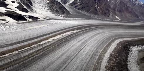
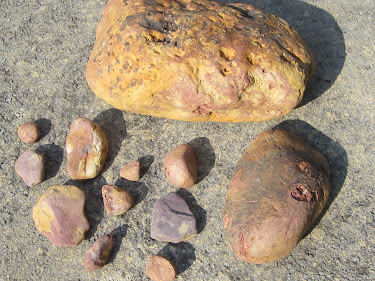
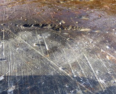
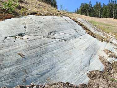
"Deterministic and opportunistic stone procurement"  -- I rather like that phrase.  I found it in Stephen Briggs's 2009 article on glacial erratics and their role in providing raw materials for stone implements in prehistory.

Briggs, C. S. 2009. Erratics and Re-cycled Stone: scholarly irrelevancies or fundamental utilities to lithic studies in prehistoric Britain and beyond?, Internet Archaeology 26. 

It appears to me to be self-evident that if I was into the manufacture of stone axes or other implements, I would use whatever raw materials were to hand at the time -- and if there were boulders lying around in the neighbourhood that looked promising, of course I would do some experiments and use them if they were suitable.  Why anybody should seek to deny that piece of common sense is beyond me -- but apparently there are those who insist that our Stone Age ancestors would only ever have used suitable rocks in the places where they outcrop.  This point is of course maintained by those who believe that stone axes and other tools were invested somehow with special or sacred qualities.  I can accept that for "ceremonial" implements which were clearly never intended to be USED, but surely, for everything else, the things made were designed for use, in the knowledge that they would eventually break and be thrown away.  The utilitarian was far more important in implement manufacture than the ceremonial.  So stone procurement was a process involving the minimisation of effort -- our ancestors knew all about the principle of costs versus benefits.

In that process opportunism must have been an important principle.

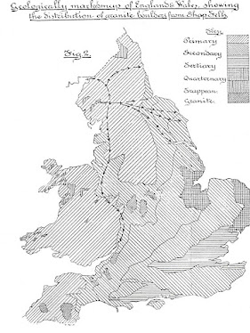
The word that is really interesting here is "deterministic" -- and if we apply the phrase to megalithic structures like standing stones, stone rows and circles, cromlechs, long barrows, round barrows and even cist graves, I think there is a great deal of evidence to suggest that the siting of these features was almost always associated with the chance occurrence of suitable slabs, boulders or pillars in the landscape.  In West Wales, as far as we can make out, all of the megalithic structures are made of stones picked up in the immediate vicinity.  I am not aware of a single ancient monument that was made with the use of large stones carried in from somewhere else.

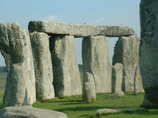
On that last point, I part company with the members of MPP's research team, who seem to think that in order for a megalithic monument (like the Waun Mawn stone settings, or Bedd Arthur, or Bedd yr Afanc, or Pentre Ifan) to be built, the site had to be pre-determined according to some "sacred" alignment or landscape setting and then the stone had to be FETCHED from somewhere else.  Even more bizarre, there is the belief that the act of fetching and carrying was in itself a sign of homage or tribute, with tribulations endured and difficulties overcome almost as an act of worship.........

It's sad that this style of thinking underpins much of the wildly exotic narrative developed by Parker Pearson and his merry gang with regard to quarrying, lost circles, stone haulage and so forth -- with Stonehenge as the distant glorious beacon and focal point of almost every Neolithic effort going on within a radius of 300 miles. Quasi-religious and quasi-political claptrap, if you don't mind me saying so.......

================================

In Stephen's paper, he has a very comprehensive list of references on erratics and their distributions, and on this blog we have of course referred to many of them over the years -- especially those involving geologists and glacial geomorphologists.  A short selection:

Briggs, C.S. 1976b 'Stone axe "trade" or glacial erratics?', Current Archaeology 57, 303.

Overweel, C.J. 1977 'Distribution and transport of Fennoscandinavian indicators', Scripta Geologica 43, 1-117.

Williams-Thorpe, O., Aldiss, D., Rigby, I.J., and Thorpe, R.S. 1999 'Geochemical provenancing of igneous glacial erratics from southern Britain, and implications for prehistoric stone implement distributions', Geoarchaeology 14, 209-46.

Shotton, F.W. 1976 'The stone axe trade and Quaternary glaciation', Quat. Res. Newsl. (Nov. 1976), 4-6.

Cummins, W.A. 1977 'Stone axe trade – or glacial erratics?', Current Archaeol. 61, 42-43.

Sandford, K.S. 1929 'The erratic rocks and the age of the southern limit of glaciation in the Oxford district', Quart. Jnl Geol Soc., 359-88.

The distribution of Shap granite erratics


This is something of a curiosity -- a map by Foster Barham (1897) discovered and published in a paper by Stephen Briggs in the 2009 volume of "Internet Archaeology"

https://intarch.ac.uk/journal/issue26/34/toc.html

Erratics and Re-cycled Stone: scholarly irrelevancies or fundamental utilities to lithic studies in prehistoric Britain and beyond?
C. Stephen Briggs (2009)

The routes shown for Shap granite erratic transport are themselves somewhat erratic, and will have been much more erratic than shown -- but the main point of interest is the final resting place.  One Shap granite erratic (at least) is shown as having been dumped in the Severn estuary.  So here is an interesting question: could the "granite debris" found at West Kennet be related in some way?

https://brian-mountainman.blogspot.com/2022/02/the-strange-case-of-west-kennet-granite.html


Shap granite has a pink or orange colouring

The Shap granite, a distinctive coarse-grained granite with large pink orthoclase feldspar, was intruded late in the Caledonian orogeny around 394 million years ago. The granite had a complex evolution involving multi-stage addition of basaltic magma to the magma chamber and assimilation of country rock. Much of the magmatic history is recorded in the compositional variations of the feldspar megacrysts. This rock has been widely used as a decorative building stone

In their analysis of the granite "grus" at West Kennet Ixer, Bevins and Pirrie decide that it has probably come from Cheviot -- maybe from Cunyan Crags.  This is well to the east of Shap.

The West Kennet grus: how far?
by Rob Ixer, Richard Bevins and Duncan Pirrie
British Archaeology, March/April 2022, pp 39-41

The geologists prefer to think of the grus (which includes some big mumps) as the remains of a traded or carried stone that had some value -- but that is based on the idea that the ice cannot possibly have been involved in its movement to its final resting place.  We shall see.....


Here is a piece of classic Daily Mail nonsense, encouraged by Pollard, Welham and others from the West Kennet research team:


Saturday 7 January 2023

Was this landscape snowed in for many thousands of years?


Many thanks to Hugh for publishing this wonderful photo on his Preseli 360 Facebook page.  It's one of the best photos I have seen which portrays the landscape on the north face of Preseli -- with the craggy tor of Carn Goedog in the centre of the photo.

This north flank was perfectly placed for the accumulation substantial thicknesses of snow and firn -- and maybe glacier ice -- during the Early and Middle Devensian -- prior to the arrive of the Irish Sea Ice at the time of the LGM.  This might have been a snowy tundra wilderness for the best part of 70,0-00 years.  

To the left, on the rolling plateau ridge, I am now more than ever convinced that a Preseli ice cap waxed and waned several times as the climate oscillated between interstadial and continuous permafrost conditions.   There is local till on these slopes, and across the moor to the right of the photo there are abundant spotted dolerite boulders that must have been carried NORTHWARDS by glacier ice.   There is a lot of till on Brynberian Moor as well.  On the slopes there are also traces of meltwater channels and morainic accumulations, and there are many examples of ice moulded forms on the tors  -- I am still trying to work out how old these features are, and how they were formed.........

Wednesday 4 January 2023

LGM eustatic sea-level curve


A new article has just been published by Gowan et al.  It's all about a spat between two different research groups, so we won't go into that, but the important thing is the emerging consensus that the lowest point reached by global sea level was about -120m around 20,000 years ago.  So at the time of the latest dated LGM ice edge maximum in the Celtic Sea (including west Wales) sea level was low, and still falling.......... 

Gowan, E.J., Zhang, X., Khosravi, S. et al. Reply to: Towards solving the missing ice problem and the importance of rigorous model data comparisons. Nat Commun 13, 6264 (2022). 

Glacierized landscapes and the advance of the ice


This is how it starts --Byers Peninsula, Livingston Island, South Shetlands. Barren tundra with permafrost, perennial snowpatches, and thicker accumulations of snow and firn in favourable locations where there are hollows and deep shadow.........


If you look at glacierized regions of today, in the polar regions, it is often very difficult to work out which areas are affected by active ice (capable of erosion, transport and deposition) and which are simply snow-covered, covered by layers of inactive or immobile layers of firn, or covered by thin cold-based ice which may be frozen to its bed. It's a bit easier if you look at a photo taken at the height of summer, when ephemeral snow has been melted off the landscape......

It's also a characteristic of the glacial geomorphology literature that there are thousands of papers, reports and books devoted to ice wastage and decay -- and the associated landforms and sediments -- but very little indeed to glacier growth by thickening and spreading. That's because there are no situations in which that is currently happening, so observations are impossible. Also, intensely glacierized regions are far more difficult to study than landscapes on which ice is melting away. Remote sensing techniques are available, of course, as are drilling and ice coring down to the glacier bed -- but spot sampling has its limitations.

So the net result of all this is that we actually know very little about how glaciers grow. This is why the myth of the "glacial bulldozer" still exists, with people imagining a vertical ice front creeping ever closer and eventually overwhelming green and fertile pastures or pre-exising tundra landscapes. Surging glaciers do that -- and have done -- in the valleys of Iceland and Norway, for example, but that sort of behaviour seems to have been very rare in the case of ice caps and ice sheets except where there are ice streams and highly deformable and well lubricated beds.

When we think of models, as created by various groups of glaciologists over the years (most recently the BRITICE-CHRONO team) the picture of an expanding and then shrinking ice sheet in some ways does a disservice since it reinforces the bulldozer image.

So what happens in reality at the end of an interglacial, when a glacial episode kicks in?

Well, the first thing that happens is that temperatures drop, with the mixed deciduous forest replaced by a boreal forest and then by tundra. Then we see the growth of seasonal and then continuous permafrost. That creates conditions where seasonal snow-melt is reduced and eventually eliminated. So where snowfall is substantial (fed by moisture-bearing winds) snowfields develop in the highlands and then in the lowlands, with seasonal melting having less and less of an effect until the whole landscape is covered with snowfields and firn. In favourable locations -- on the highest plateaux and in mountainous areas where there are substantial snow-collecting hollows facing north or north-east the firn might thicken substantially until we see the creation of glacier ice. Where there are convenient slopes or discharge routes, glaciers may start to flow and expand, pushing into areas which are otherwise covered with perennial snowfields.

What needs to be emphasised is that this happens over a very long timespan. From the peak of the last (Ipswichian) interglacial -- around 120,000 years ago -- the global records show an intermittent sea-level fall over something like 90,000 years, associated with climatic cooling and increased glacierisation in high latitudes and high mountain regions during MIS5, MIS4 and MIS3. Ice core and other records indicate up to 25 interstadials, but the records are difficult to interpret and some of the "warmer episodes" might have been local or regional rather than being of global significance.


Quote:
During the Devensian, periglaciation took place beyond the ice limits, as demonstrated by regional patterned ground and involutions dated to 60–55 ka (MIS 3), 35–31 ka (MIS 3), 22–20 ka (MIS 2) and 12–11 ka in eastern England. The Devensian cold periods were interspersed with warmer interstadials, most notably the Chelford Interstadial (MIS 5c, approx. 108–92 ka), the Brimpton (MIS 5a, approx. 86–72 ka) and the Upton Warren (early during MIS 3; possibly approx. 42.5–38.5 ka, according to Catt et al). However, the chronologies, environments and climatic conditions associated with these interstadials remain not well understood.

Mid-Devensian climate and landscape in England: new data from Finningley, South Yorkshire
Philip I. Buckland et al, Royal Society Open Science 6 (7),
Published:10 July 2019

Quote:
...........the evidence indicates that the last BIIS expanded after a period of, at most, very restricted glaciation. A spin-up point for the model experiments was therefore set at 38.3 ka BP, coinciding with a period of major climate amelioration within the GISP2 ice-core record. 

Patton, H., Hubbard, A., Glasser, N. F., Bradwell, T. & Golledge, N. R. 2013 (July): The last Welsh Ice Cap: Part 1 – Modelling its evolution, sensitivity and associated climate. Boreas, Vol. 42, pp. 471–490.
The last Welsh Ice Cap: Part 1 – Modelling its evolution, sensitivity and associated climate.  

https://www.researchgate.net/publication/248381136_The_last_Welsh_Ice_Cap_Part_1_-_Modelling_its_evolution_sensitivity_and_associated_climate

But at what point does streaming ice from far afield start to affect an area like West Wales, where there may be lowlands, upstanding hill masses and plateaux which might support local ice caps?  It's clear that this happens very late in the day, towards the back end of a full glacial cycle. The glacierization build-up phase (with extensive snow and ice cover on the landscape) may last for 70,000 years or more, interrupted by short-lived cooling and warming phases or by changes in precipitation and other types of "climatic forcing".  But eventually, when the whole land surface has become deeply buried by locally-generated ice, maybe 500m or more in thickness, the big brute from the north begins to dominate -- in this case with the arrival of the Irish Sea Ice Stream - as cold-based ice is replaced by ice that is capable of sliding on its bed.  Streaming ice then begins to do serious damage, eroding bedrock, picking up erratics and incorporating pre-existing periglacial and other deposits, and modifying a previously protected landscape in a multitude of different ways.  The direction of ice flow is now determined not by the details of local topography but by the surface gradient of the ice stream; in the case of Pembrokeshire ice movement seems to have swung through an arc of maybe 60 degrees, but with a dominant flow from NW towards SE.   It appears that the Welsh ice cap did not greatly affect Pembrokeshire, but ice from the Welsh uplands may well have filled Cardigan Bay, creating a constriction that affected Irish Sea ice flow directions.  From the BRITICE-CHRONO modelling, Irish Sea ice affects the area for maybe 3,000 years.  

https://www.science.org/content/article/watch-ice-sheet-melt-and-great-britain-and-ireland-emerge#.Y2DUPaCmHNI.twitter

Then, after maybe less than 1,000 years of "peak glaciation" the ice sheet starts to collapse, and the ice stream power is dramatically reduced. Forward flow is stopped, and catastrophic ice wastage sets in -- so that a landscape deeply inundated beneath glacier ice is gradually revealed, with an intermittent cover of glacial and fluvioglacial deposits which are remobilised and redistributed as the last remnants of buried ice melt away.

On a glacial cycle timeline this is all very asymmetrical, with (1) a long period of "increasing glacierisation" with minimal landscape effects followed by (2) a period of intense activity involving streaming ice and then (3) by a short period of catastrophic ice wastage and sediment redistribution.  That's the simplest situation imaginable.  Of course, in reality it is always more complex.  Climatic oscillations occur on a variety of different scales, and long-term cooling is sometimes interrupted by intermittent warmer phases, just as long-term warming is interrupted by "cold snaps" such as the Younger Dryas phase of c 12,000 years ago and the Little Ice Age that set in during the Middle Ages. Changes in oceanic and atmospheric circulation can also have the effect of changing wind direction and strength, and changing patterns of precipitation.  These are all things that are built into the increasingly sophisticated  modelling of ice sheet growth and decay by the BRITICE-CHRONO group and others.

So just as the idea of a spectacular ice front marching across the landscape is an image that has no basis in reality, the idea of a later ice front retreating across a landscape during deglaciation is equally misleading.   Ice stops moving forward -- it does not RETREAT.  It simply wastes away where it lies, mostly from the top down. So just as the local ice caps of Aubrac in France and Glamajökull in Iceland melted away completely, leaving but a few traces of their former existence,  the same thing is happening at the moment to Drangajökull, leaving very few traces up on the high plateau where ice movement was minimal, but complex associations of glacial and fluvioglacial deposits and landforms in the valleys affected by streaming ice.

And we should be careful about using the term "ice limits" as well.  I have to admit to using the term far too frequently myself, as a shorthand expression which is easily understood.  On Quaternary maps we see "ice limits" portrayed all too often as straight lines, even across mountainous terrain -- but in reality ice edges are generally "fingered" or crenellated in sympathy with the landscape, and beyond an ice sheet edge there are generally scores if not hundreds of smaller icefields,  ice caps and snowfields -- again in sympathy with the lie of the land and the patterns of snowfall. So the real ice edge is not just crenellated but also fragmented.........

https://brian-mountainman.blogspot.com/2022/10/the-inexorable-ice-front-fact-or-fiction.html

https://brian-mountainman.blogspot.com/2022/10/the-aubrac-ice-sheet.html

https://brian-mountainman.blogspot.com/2022/10/lessons-from-aubrac.html

https://brian-mountainman.blogspot.com/2012/08/the-ice-sheet-ice-cap-snowfield.html

https://brian-mountainman.blogspot.com/2009/12/lessons-from-jameson-land.html

https://brian-mountainman.blogspot.com/2011/01/last-glaciation-protective-ice-cover-in.html

So how does all this relate to the evidence on the ground in West Wales and elsewhere?  Watch this space.......


A depression filled with highly mobile waterlogged sediments fed by summer snowmelt -- 
Byers Peninsula, Livingston Island


Another summer photo from Byers Peninsula -- a periglacial landscape with some waterlogged areas and others which are relatively dry, dominated by frost processes and slope breccia accumulations.


For 70,000 years or more, in the Early and Middle Devensian, the landscape across much of Pembrokeshire might have looked like this......

One of the biggest problems with all of this is the claim by Rolfe et al that Lundy Island was affected by glacier ice during the Early Devensian:

https://brian-mountainman.blogspot.com/2015/03/a-lundy-island-spat.html
Rolfe, C.J., Hughes, P.D., Fenton, C.R., Schnabel, C., Xu, S., Brown, A.G., 2012. Paired 10Be and 26Al exposure ages from Lundy: new evidence for the extent and timing of Devensian glaciation in the southern British Isles. Quaternary Science Reviews 43(2012): 61-73.

This research really is an outlier, as far as I know quite unsupported by any other research results from the Celtic Sea arena.  The problem with it is that it is based very largely on cosmogenic exposure ages obtained more than a decade ago -- and as pointed out by others, that was a time when our understanding of "exposure age inheritance" was not very great.  So the "Early Devensian glaciation" of the Bristol Channel arena is still speculative and unproven. 


Carr, Simon, Hiemstra, John F. and Owen, Geraint (2017) Landscape evolution of Lundy Island: challenging the proposed MIS 3 glaciation of SW Britain. Proceedings of the Geologists' Association, 128 (5-6). 722 - 741

But I don't go along with Simon Carr, John Hiemstra and Geraint Owen either.  They claim that there is no evidence of any Late Devensian glacial activity in the Bristol Channel -- I think there is quite strong evidence which needs to be considered carefully.