THE BOOK
Some of the ideas discussed in this blog are published in my new book called "The Stonehenge Bluestones" -- available by post and through good bookshops everywhere. Bad bookshops might not have it....
To order, click
HERE

Wednesday 30 September 2020

Online: The BGS memoirs for South Wales


I have hunted for these (mostly old) Geological Survey Memoirs online, many times, without finding them.. ..... Now I have discovered them, and below I post the links. They ARE very valuable, since they record in great detail the observations of the old geology field surveyors -- free of any great theorising. Most of the observations are from the early 1900's -- before there were major transformations of the landscape through urban expansion and agricultural "improvement." There is a lot of data in these old documents. In each one the superficial deposits are described towards the end of the volume. 

In checking out the geology of particular sites, I often use these memoirs together with the Geology of Britain Viewer:

https://mapapps.bgs.ac.uk/geologyofbritain/home.html

Full list of online memoirs:
https://webapps.bgs.ac.uk/data/maps/maps.cfc?method=listResults&mapName=&series=&scale=&pageSize=100&start=100
(Geology of the South Wales Coalfield)

Individual memoirs -- various editions.  The authors for West Wales included Cantrill, Strahan, Thomas, Jones, and Dixon -- good field geologists, all of them.....

227 Milford
http://pubs.bgs.ac.uk/publications.html?pubID=B01813

228 Haverfordwest
http://pubs.bgs.ac.uk/publications.html?pubID=B01814

Sheet 229 Carmarthen
http://pubs.bgs.ac.uk/publications.html?pubID=B01815

Sheet 230 Ammanford
http://pubs.bgs.ac.uk/publications.html?pubID=B01817

232 Abergavenny
http://pubs.bgs.ac.uk/publications.html?pubID=B01821

244 / 245 Pembroke and Tenby
http://pubs.bgs.ac.uk/publications.html?pubID=B01825

246 West Gower and Pembrey
http://pubs.bgs.ac.uk/publications.html?pubID=B01826

247 Swansea
http://pubs.bgs.ac.uk/publications.html?pubID=B01827

248 Pontypridd and Maesteg
http://pubs.bgs.ac.uk/publications.html?pubID=B01830

249 Newport
http://pubs.bgs.ac.uk/publications.html?pubID=B01832

249 Newport (new edition)
http://pubs.bgs.ac.uk/publications.html?pubID=B01833

261 / 262 Bridgend
http://pubs.bgs.ac.uk/publications.html?pubID=B01835
(*2nd edition 1990 by Wilson, Davies, Fletcher and Smith)

261 / 262 Bridgend
http://pubs.bgs.ac.uk/publications.html?pubID=B01834
(first edition)

263 Cardiff (3rd edition)
http://pubs.bgs.ac.uk/publications.html?pubID=B01839

Note:  Memoirs were never published for the two map areas in which we are most interested -- 209 St David's and 210 Fishguard.  Not sure why........

PS.  There are problems with these links -- a common issue with Blogger.  I am trying to sort out where the problems lie........

Saturday 26 September 2020

What was Stonehenge for?


Love it!  Kindly posted on Facebook by Pete Glastonbury........

Waun Mawn -- don't look, don't see.........


In the past, I have posted a number of serious criticisms about the working methods of Parker Pearson and his team at Waun Mawn -- flagged up, as we all know, as the site of a great stone circle which was built of sacred stones from the two "bluestone quarries" at Rhosyfelin and Carn Goedog, which was then (after a few centuries) dismantled and carted off to Stonehenge.

This narrative has been carefully manufactured and promoted, and will no doubt be developed and further justified in future publications -- but the lack of scientific integrity in the whole process is now so worrying that it reflects badly on the archaeological establishment, which -- by all accounts -- simply stands back and cheers the perpetrators on.

https://brian-mountainman.blogspot.com/2018/05/waun-mawn-and-invisible-dolerites.html


https://brian-mountainman.blogspot.com/2019/07/waun-mawn-strange-art-of-seeing.html


https://brian-mountainman.blogspot.com/2018/11/waun-mawn-clutching-at-straws.html


https://brian-mountainman.blogspot.com/2019/06/waun-mawn-and-stonehenge-fantasy.html


https://brian-mountainman.blogspot.com/2018/09/waun-mawn-what-we-know.html


In a post more than a year ago I said:

I have been reviewing the Waun Mawn evidence, and have been struck again by the apparent determination of MPP and his team to see things that aren't there and to miss the things that are. For a start, they seem determined to ignore the fact that there are outcropping dolerites just a stone's throw from their putative proto-Stonehenge circle of standing stones. They so badly WANT the stones to have come from somewhere else (namely bluestone quarries) that they apparently refuse even to consider the idea that any stones erected on this site may well just have been picked up locally.

Then we have all the other rather interesting features on Waun Mawn -- all the other standing stones, 
stone sockets, possible ruined burial sites, ring cairns, deer park enclosure traces, quarrying pits, embankments and so forth. Not all of them are prehistoric and relevant for the proto-Stonehenge debate, but some of them certainly are.

Why is it that thus far the archaeologists appear not even to have noticed any of these features? Strange, given that they point to a rather interesting cultural complex around Tafarn y Bwlch, Waun Mawn and Banc Llwydlos. Does it not suit their purpose to emphasise all these other traces of Neolithic / Bronze Age settlement?

Or are the archaeologists so intent on proving the uniqueness of the supposed Waun Mawn circle that all other features in the vicinity have to be ignored?

I support these points with references to a number of more detailed posts in which field observations are presented.  Anyway, I have now been back again, walking the terrain and making notes, and can add further points as a result:


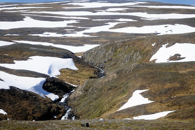
1.  There are outcropping Fishguard Volcanics rhyolites around Bedd yr Afanc, just a couple of kilometres to the east of Waun Mawn, and also extensively to the NE, N and NW of Waun Mawn.  Given the scatter of glacial deposits across the moorland and the known direction of ice travel from the N and NW, it is much more likely that any rhyolites found at Waun Mawn have been carried into the area by overriding ice.  It follows that any link between Waun Mawn and Rhosyfelin (4 kn to the NE) is vanishingly unlikely.

2.  The presence of spotted dolerite erratic boulders around Glanyrafon, while to some degree puzzling, indicates that we really know very little about the distribution of spotted dolerites across the landscape by glacial and other processes.  It is apparent that there are other spotted dolerite outcrops in this landscape that have not yet been identified.  Therefore any assumption that spotted dolerite fragments of boulders at Waun Mawn must have come from Carn Goedog or any other known location on the Preseli ridge has be be premature if not downright unreliable.

3.  New examinations across the landscape of western Preseli confirms that the litter of dolerite and rhyolite boulders across the landscape is very extensive indeed -- sometimes related to the presence of rock outcrops, sometimes to periglacial blockfields, and sometimes to morainic accumulations.  As I have said before, there are thousands of slabs, pillars and boulders on the hillsides and in the depressions -- and these were abundantly available for the local inhabitants who were doing things with stone in the Neolithic and the Bronze Age.


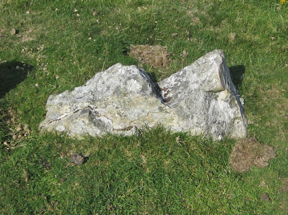
Dolerite stone setting on Waun Mawn -- this might be a collapsed cromlech, like another found on Brynberian Moor.

4.  The abundance of prehistoric features across this landscape is spectacular, and every time I walk across it I quite literally stumble across stone settings that are undocumented.  I am not saying that this terrain (including Tafarn y Bwlch and Banc Llywylos) was a sort of El Dorado or cultural hub -- but certainly, because of lucky chance, this area has been spared from the damage associated with land clearance and "agricultural improvement".  

So I come back to my earlier points.  Why is it that Parker Pearson and his colleagues (including geologists Ixer and Bevins) have completely ignored the geological map and field observations to maintain the pretence that any spotted dolerites or rhyolites at Waun Mawn (in the "stone setting" or in the debitage) have been carried here from Rhosyfelin,  Carn Goedog or Cerrigmarchogion?  This is, not to put too fine a point on it, deliberate falsification of the evidence designed to underpin a ruling hypothesis.

Why is it that they fail to record the presence of abundant dolerite and rhyolite "monoliths" of all shapes and sizes littered across the landscape?  Again, because this is an inconvenient fact that does not do anything to help the hypothesis.  Those involved appear happier when misleading their readers than when telling the truth.


Why is it that they even ignore the archaeological context in their mentions of Waun Mawn?  This is extraordinary, given that these people are archaeologists, writing for an archaeological readership.  Are their readers all stupid?  The truth is that the Waun Mawn stone settings (whatever their wider significance may be) are simply a part of a landscape quite rich in prehistoric remains of many kinds.  One can only conclude that it is the intention of the MPP research team members to maintain a pretence that the Waun Mawn "mega circle" -- if it ever existed -- was an aberration, something quite unique and special enough to have been uprooted and carried off to Stonehenge in a spectacular act of reverence or political solidarity........  and as we know, everything associated with Stonehenge has to be amazing enough to elicit purple prose and attract banner headlines.

This brings me to my final point -- the lack of control studies.  The diggers at Waun Mawn have wandered across this landscape (we know that they have looked at Bedd yr Afanc) and they must know all about the Dyfed Archaeology reports on Banc Llwydlos and other concentrations of prehistoric features, but if they want to demonstrate the uniqueness of Waun Mawn, Rhosyfelin or Carn Goedog, they have to do it through comparative studies of other sites.  There are organic remains in the sediments at all three sites, suggesting long occupation.  At the former sites these remains and dates are used by MPP and his colleagues as confirmations of quarrying activities, and at Waun Mawn as confirmation of the presence of a great stone circle.  But the "occupation traces" do nothing of the sort -- they simply show that there were human beings who used these sites.  That comes as no surprise -- we already knew that prehistoric people used the whole of the landscape and exploited its resources.  Until the "quarrymen" can show that the density and types of occupation traces are unique to the sites investigated, their research has no value.  But they have done no control studies around other rock outcrops in the Brynberian valley which can be used in the interpretation of Rhosyfelin; they have done no control studies for Carn Goedog at any other dolerite tors on Mynydd Preseli; and they do not even accept the presence of any other prehistoric sites on Waun Mawn which might have similar or even more abundant) traces of Neolithic occupation than the putative stone circle.

So skewed is this research that it deserves to be ridiculed rather than revered.  The people responsible for it are not naive -- the manner in which the "proto-Stonehenge" mega-circle is being promoted has all the hallmarks of another scientific hoax.

-----------------------------------

https://www.bluestonebrewing.co.uk/wp-content/uploads/2019/05/Waun-Mawn-2018-interim-report-lite.pdf

Waun Mawn stone circle: the Welsh origins of Stonehenge (2019)
Interim report of the 2018 season
By Mike Parker Pearson, Josh Pollard, Colin Richards, Kate Welham, Dave Shaw, Ellen Simmons and Adam Stanford
Bluestone Brewery, Newport.

===========

Mike Parker Pearson, Richard Bevins, Rob Ixer, Joshua Pollard, Colin Richards, Kate Welham. 2019. Long-distance landscapes: from quarries to monument at Stonehenge. MEGALITHS AND GEOLOGY, Boaventura, Mataloto & Pereira,
eds. (2019). pp. 183-200

https://www.academia.edu/44065619/Long_distance_landscapes_from_quarries_to_monument_at_Stonehenge?auto=download&email_work_card=download-paper

Wednesday 23 September 2020

Those Stonehenge bluestone monoliths -- we need cosmogenic nuclide dating!


Now that the geologists have admitted that the Stonehenge bluestones have come from multiple provenances, and now that the "quarrying" hypothesis simply seems like a mad aberration, can we please get some proper dating done on the surfaces of all those bluestone erratics lying about at Stonehenge?

Cosmogenic dating is now so ubiquitous in geochronology studies, and so reliable, it seems crazy that the bluestones have not already been studied -- so that we can see, once and for all, whether they are freshly quarried (in which case the outer surface of a monolith should be no older than c 5,000 yrs BP) or whether they have been bombarded with cosmic radiation for tens of thousands -- or maybe hundreds of thousands -- of years.  When were these boulders dumped, and where?  During the Anglian Glaciation, or the Devensian, or some other?  It would be good to know......

This is a simple explanation of what this is all about:

 http://www.antarcticglaciers.org/glacial-geology/dating-glacial-sediments-2/cosmogenic_nuclide_datin/

The video attached to the article is interesting too.

Of course the taking of a small rock sample from an exposed surface might be deemed "physical damage", and may cause EH to retreat into full "sacred stone" mode -- but scientifically there is absolutely no excuse for holding back for any longer.  As long as EH continues with the line that the surface of the stones must not be damaged, except by jackdaws and starlings,  the more pseudo-science and mythology will flourish. Goodness knows, there is enough of it about already.......

Tuesday 22 September 2020

An enigmatic landform on the north slope of Preseli


I'm not often flummoxed by landforms, but I have found one that is seriously confusing.  It's on the north slope of Preseli, on the area labelled as Banc Llywdlos, at grid ref SN093325.  It's a faint armchair-shaped hollow in the hillslope, so subtle that I have never even noticed it from a distance, and I literally stumbled across it as I was traversing the hillside.  It's so subtle that it does not show up on the contour maps, and it is very difficult to see on the satellite imagery as well.  It's also virtually impossible to photograph, except maybe with a very low sun in the winter -- but because it is on a north-facing slope it's often in shadow in the cold part of the year.

The dimensions are approx 175m from one flank to the other, and c 150m front to back.  The altitude of the back edge is c 396m and the front edge is at c 350m.  It looks straight down on the large fenced enclosure that contains water supply springs -- this is shown on the 1:25,000 Explorer map.

Hereabouts on the mountain slope the vegetation is wet grassland, but inside the amphitheatre it is even wetter, except for a debris tongue which is marked by bright green grass -- this emanates from a cut towards the upper edge of the "cwm".  The undulating ridge that runs across the mouth of the cwm is much drier, and that is cut into by a number of small gullies, the westernmost of which has a discernible debris tongue beneath it.  To the east of the debris tongue within the basin there is a prominent mound, which has a number of dolerite boulders embedded.

My first instinct was that this feature is a landslide scar caused by slope failure, but the distinct ridge across its mouth does not make sense -- a real debris flow or landslide would have carried debris much further downslope.  There are two discernible small debris flows, but the creation of the little basin must be down to a different process entirely.  Which brings me to the process called nivation, which operates at a very small scale and at a slow pace in locations where permanent snowpatches exist.  Well, this is a perfect place for perennial snowpatches during cold episodes  -- facing directly north, with en extensive undulating plateau above to guarantee a supply of wind-drifted snow.  So this is my best guess -- the ridge across the mouth of the feature may have accumulated very slowly -- maybe over a couple of thousand years, by winter freeze-thaw (and rock breakage) and then sapping and meltwater flow beneath a permanent snowpatch.  This is at a completely different scale than the formation of cwms or corries formed beneath small mountainside glaciers.  In these, the processes can of course be referred to as "glacial" without any risk of disagreement among experts!  The small debris tongues and gullies have come later as the feature has been modified -- probably during periods of exceptionally heavy rainfall and super-saturation of the ground surface.

I think that this feature lies above the upper limit of the Irish Sea Glacier in this neighbourhood (I have assessed that as 340m) -- but it is not beyond the bounds of possibility that the ridge across the mouth of the little basin is actually an ice marginal moraine rather than something generated by a snowpatch.  

So there we are then.  It will be good to know what others may think....


Nivation processes in soft sediments


A Scottish snowpatch, melting fast.  Many different processes operate in environments like this, and there can be saturated (and flowing) sediments, collapsing snow tunnels, and a lot of water about.  I have had a few hair-raising experiences walking across snowpatches like this one......


Snowpatches on the shady side of an upland plateau.

https://brian-mountainman.blogspot.com/2015/05/rosemergy-niche-glacier-cornwall.html

This is a post about the postulated Rosemergy niche glacier in Cornwall.  I'm not sure there was a niche glacier here, but there might well have been nivation, and in reality there is a continuum of features in landscapes such as these:


Seasonal and perennial snowpatches in Honningsvag, Norway


Snowpatches in the south Shetland Islands, Antarctica

See this tpost too:


Satellite image of part of the Glama Plateau, NW Iceland.  Structural trends can be picked out.  The smaller snowpatches are probably seasonal -- but many of the larger ones are perennial, and there will be associated nivation processes.  Some of them may have firn or even glacier ice at depth, and so might be considered to be "niche glaciers".


Monday 21 September 2020

More prehistoric features on Banc Llwydlos


(1)  Prehistoric (Bronze Age?) round house?


This roughly circular structure is just a few metres from the small stream called  Ffos Dyrysienog, one of the headwater streams of the Afon Brynberian.  This is the Dyfed Archaeology description:

PRN 100705 NAME BANC LLWYDLOS TYPE SHEEP FOLD PERIOD Medieval 
NGR SN09513302 CONDITION Damaged STATUS FORM Stone structure

SUMMARY A possible sheepfold situated on a northwest facing slope of Banc Llwydlos at 250m above sea level, lying to the east of a stream.

LONG DESCRIPTION A possible sheepfold situated on a northwest facing slope of Banc Llwydlos at 250m above sea level, lying to the east of a stream. It is sub-circular in shape and of dry stone construction whose walls survive to between 4/5 courses high. The enclosure has an approximate diameter of 8.9m. There is an entrance on the west (facing the stream) measuring 1.2m wide. It is possibly a later re-use of an earlier structure. It was recorded by P Drewett in 1984 during field survey and listed as ‘hut cluster (circular stone huts)’ (site no 109).
Depicted as 'sheepfold' on OS County series Pembroke. XI.9 1889 & as 'old sheepfold' on 2nd edition (1907).

I'm not at all sure that this ever was a sheepfold -- the walls are nowhere near high enough to keep sheep on the inside -- and even if they have collapsed, where are the fallen stones?  And it would have been stupid to have the entrance on the west side, so close to the stream -- driving sheep in would have been a nightmare.  So I think it was originally a roundhouse in a very desirable location, on a dry bank very close to a permanent water supply.  Indeed, the eastern part of the walled structure is turf-covered, and there are signs of another semi-circular embankment outside the one visible in the photo above.  So I think it/s prehistoric rather than medieval -- but no excavations have ever been conducted here. 

---------------------------------------------

(2) Collapsed cromlech

I am so convinced by this one that I have not even bothered with a question mark!  It's a small and rather primitive structure about 500m north of the previously mentioned structure, and about 100m from the same stream.  Grid reference:  SN 096333.  It's on the edge of a dry bracken patch, on a small grassy bank with an undulating surface.  There is a clear circular arrangement of stones, c 6 m across.  There are 23 small stones around a slight hollow, with two "stone clusters" on the southern edge.  On the west side of the hollow there are two much bigger stones, one that appears to be a leaning support stone, c 70 cm high, and a fallen capstone which has the dimensions 1.3m long x 70cm wide x 30cm deep. 

I have not been able to find any record of this feature, and will welcome some opinions from others who might like to examine it.......

The circular arrangement of stones suggests that there might have been a small covering earth mound -- but it might also have been a "sub-megalithic" burial chamber with just one edge of the capstone supported.


Rough plan of the feature


The Late Devensian trimline on the north face of Preseli


Brynberian Moor and the north face of Preseli

I have mused on many previous occasions on the extent of Late Devensian ice in the great basin on the northern flank of the Preseli upland ridge.  The "reading of the landscape" and the interpretations have to be very subtle indeed, because this is a landscape free of great dramatic landforms and thick sediments.  I freely admit to being confused!  But I think things are gradually coming together....... and today I had a fabulous walk from Tafarn y Bwlch to Carnau Lladron, on which I discovered many new things.  

Here are some of my earlier observations, partly made on a walk with Chris:

 https://brian-mountainman.blogspot.com/2016/08/the-devensian-preseli-ice-cap.html

On previous visits I have come to the view that around 340m altitude, on the mountainside, there is a subtle change from blockfields with thin till and many dolerite rock outcrops to thicker till with some surface expression.  This till extends right across the depression in an unbroken sheet, with some higher mounds and ridges and many small stream valleys cut into it.  There was, I think, no big "Lake Brynberian" between the edge of the Irish Sea ice and the upland ridge -- but there are intermittent thin clays that look like lacustrine deposits, so there may well have been short-lived bodies of impounded meltwater during the ice wastage process.


The Hafod Tydfil trackway, cut across clay-rich till on the floor of the depression.


Striated cobble of rhyolite (?) found in fresh till adjacent to the Hafod Tydfil track, SN114341

Today, in examining the stream cuttings on the slope above Banc Llwydlos,  I came to the view that the higher exposures in the cuttings are cut into bedrock, with a thin veneer of till that seems to be local (from the Preseli ice cap?) but that there is a substantial change in the nature of the sediments at about 335m altitude, or a little above.  That's very close indeed to my estimate of a few years ago -- and it matches, too, with my observations from the Carn Goedog - Carnalw area, and with my conclusions that both of those tors were inundated by Irish Sea ice coming in from the north.

My working hypothesis of a trimline at around 340m seems now to be supported by additional evidence, and I see no reason to revise it.  


So the ice margin postulated by the Geological Survey (above) is right in general terms, but not in detail.  On the north face of Preseli it is too low, and needs to be pushed further south to approx the 340m contour..  Also, in the light of the morainic accumulations around Gernos Fawr, at Cilgwyn and other locations I am assuming that the Carningli - Dinas Mountain upland was overridden by Devensian ice, so the ice margin in that area needs to be pushed to the south of Cwm Gwaun, as shown in this map:


Watch this space..... work in progress......


Sunday 20 September 2020

Bluestone rock types at Stonehenge


The one original point in the latest book chapter by MPP et al (2019) is a table of bluestone rock types contributed by Rob Ixer and Richard Bevins.  We reproduce it below, with acknowledgement of the source. 
 

From:
Mike Parker Pearson ey al, 2019.  Long-distance landscapes: from quarries to monument at Stonehenge MEGALITHS AND GEOLOGY. Boaventura, Mataloto & Pereira, eds. (2019). pp. 183-200
https://www.academia.edu/44065619/Long_distance_landscapes_from_quarries_to_monument_at_Stonehenge?

The table lists 13 different bluestone "rock types" found at Stonehenge, and it is very interesting because it effectively blows the quarrying hypothesis out of the water.  

There are actually far more than 13 rock types represented here -- for there is considerable variation in geochemistry and petrology within some of these groups.  The linking of rock types with specific stones is for the most part not at all sound,  since most of the Stonehenge bluestones have not been directly sampled, and the geologists have had to analyse debitage or fragments assumed to have come from particular stones.  For example, we do NOT know that the "Rhyolite Groups A-C" fragments have come from Stones 32d and 32e.  We do not even know that foliated rhyolite fragments at Stonehenge have really come from Rhosyfelin, in spite of what Ixer and Bevins may say.  The "spotted dolerite ungrouped" category  (assigned to 21 different numbered bluestones) contains considerable variation, and many different provenances are probably represented.  No stones have been shown in the scientific literature to have come from Cerrig Marchogion or Talfynydd.  The Altar Stone (80) has never been sampled, and we do not know that it comes from the Senni Beds.  The "Lower Palaeozoic sandstone" should be plural, not singular, and the assignments of studied sandstone fragments to stones 40g and 42c are acts of faith, not statements of fact.  The authors themselves admit that their samples point to two different sources.  We can go on -- but let's just point out that the table is useful as a guide, but that the assignment of particular stones to particular rock types is in many cases NOT solidly evidence-based.  As I have said many times before, there may be as many as  30 different provenances represented in the full assemblage of bluestone monoliths and debris at Stonehenge.

In that context, the very idea of Neolithic quarries having some importance becomes somewhat ridiculous.  Are the authors of this new book chapter suggesting that there were up to 30 quarries?  If not, what are they suggesting?  That they quarried monoliths from Rhosyfelin and Carn Goedog (in very difficult locations) just for fun, and just picked stones up from everywhere else?  Interestingly enough, this table of rock types is not discussed at all in the text.  I'm surprised that MPP allowed it to be published at all, since he must have realised how damaging it would be..........

The biggest bombshell here is the admission that most of the spotted dolerites at Stonehenge have NOT come from Carn Goedog, although this has been claimed over and again in the literature and in press releases.  When do we get to see the corrections and the apologies?

Only five stones are now assigned to Carn Goedog -- 33, 37, 49, 65, and 67.  I do not accept that this assignment is soundly based.  

Anyway, let's take a look at them, courtesy of  Simon Banton's excellent "Stones of Stonehenge" web site: 

33

37

49

65

67

Are the authors of this new book chapter seriously suggesting that this little assemblage of spotted dolerite bluestones have been lovingly quarried and selected for use at Stonehenge (or even at some wonderful "proto-Stonehenge" at Waun Mawn) as first-class monoliths?  Stones 33 and 67 might loosely be called pillars, but stone 49 is an irregular battered slab, and stones 65 and 37 can only be realistically described as heavily weathered and abraded boulders.  MPP has argued over and again that Carn Goedog was quarried because that is where there was columnar jointing, and where the most perfect pillars could be found..........

These five stones are typical glacial erratics which have been faceted and abraded in glacial transport and subsequently weathered as a result of exposure to the atmosphere for maybe 20,000 years.

Oh dear, for how much longer do we have to put up with the fantasy world created by MPP and his fellow storytellers?

PS. 23 Sept.    I have now checked out the 2016 paper by Ixer and Bevins on the Fishguard Volcanics
Group A" debitage.  They say: "Volcanic Group A lithics are widely and randomly distributed throughout the Stonehenge Landscape; temporally, almost none of the debitage has a secure Neolithic context. The debitage cannot be matched to any above-ground Stonehenge orthostat but may be from one or more of five buried and, as yet, unsampled stumps."  And yet, in the table reproduced above, they quite blatantly assign 5 of the Stonehenge bluestones to this source.   Apparently, scientific caution is abandoned.  What on earth are these guys playing at? 

Foliated rhyolite on Brynberian Moor, north flank of Mynydd Preseli


Today, in glorious sunshine with hardly a breath of wind, my wife and I enjoyed a walk on Brynberian Moor (Waun Brwynant).  We had our picnic lunch at Bedd yr Afanc, which I have described before.

 https://brian-mountainman.blogspot.com/2016/06/bedd-yr-afanc-geology.html

Now I am quite convinced that the bedrock on the slight ridge (on which the grave of the fearsome monster is located) is rhyolite, which looks remarkably similar to that of Rhosyfelin.  The geology map confirms this, showing Fishguard Volcanics for some distance south of Brynberian -- rhyolitic tuffs (ashes) and lavas.  Rhyolite fragments are littered about everywhere, and there is one large slab projecting though the turf which I think is a bedrock outcrop:


I was able to look at the stones that make up the remains of the gallery grave.  They are quite small, with none of them projecting more than 1m above the ground surface, and they are of all shapes and sizes.  Clearly there was no careful selection -- they were all picked up locally and used more or less where found.  Of the 42 or so stones still visible,  33 are made of dolerite, one seems to be of spotted dolerite, one is gabbro, and seven are rhyolite.  Many of the stones are smaller than skull size, and were probably used as packing or filling stones between the larger boulders used for the main structure of the monument.

These are two of the rhyolite stones in the setting:

Small foliated rhyolite stone.

A jagged (broken?) stone  -- rhyolite without obvious foliations.

Out on the moor, the steep slope facing south at SN113344 seems to me made of rhyolite, which then extends out onto the moor for at least another 500m, as far south as SN114341.  It is variable in texture, but the light blue colour is consistent, as is the whitish weathering crust on fragments exposed in the track leading to Hafod Tydfil. Around the northern tip of the enclosed land of Hafod Tydfil, dark mudstones of the Abermawr shales appear in abundance on the track, indicating a change in bedrock type.  I think that the boundary between the Fishguard Volcanics rhyolitic tuffs and lavas is about 500m away from where it is shown on the map.  

I wonder if the Brynberian Moor foliated rhyolites have been sampled by the geologists?  If not, they need to get looking, since we might have in this vicinity a source for at least some of the foliated rhyolite debitage at Stonehenge.

Finally, one very important point.  This gallery grave is a small and very crude structure, which may mean that it is older than many of the more spectacular Neolithic burial sites in Pembrokeshire.  The stones have NOT been chosen because they were pillars or slabs -- they were used because they were handy, in the immediate vicinity.  The rhyolites and dolerites are used randomly in the structure, and it is obvious that the stones have not been arranged purposefully with either texture, colour or origin in mind.  If either the dolerites or rhyolites had been "venerated" in some way they would surely have been arranged preferentially with one rock type in the passage or gallery, and another at the portal, for example.  My conclusion, from examining this and many other Pembrokeshire tombs, is that neither rhyolite nor spotted dolerite was revered or "selected" by the builders. They could not have cared less where their stones came from -- and this is a very different narrative to that of MPP, who seems to suggest in his articles that every stone used by the tomb and circle builders had ritual meaning.......


Saturday 19 September 2020

The Stonehenge bluestone erratic boulders -- when were they emplaced?

What do Stonehenge and East Greenland have in common?  Not a lot, you might think ---- but it might just be that work done on this massive end moraine may help to solve the problem of when, and how, the Stonehenge bluestones were moved from West Wales to Salisbury Plain......


East Greenland  (Kjove Land) 1962.  On the delta terrace on the eastern flank of the massive Holger Dansker Briller end moraine, at the exit of a diffluent glacial trough. There are erratic boulders on the terrace, and even more on the ice-contact slope and on the inner moraine surface.


In the middle distance, the terminal moraine with its flattish delta terrace top.  Beyond it, hidden from view, are the two lakes of the Holger Danskes Briller.

The pretence that the bluestones at Stonehenge are all pillars has been promoted vigorously for many years, by many people who should know better.  As I have pointed out many times before, the great majority of the 43 bluestones are not pillars but slabs and boulders which look for all the world like an erratic assortment collected from near the front of a wasting glacier.  They are weathered and heavily abraded, with very few sharp edges -- suggesting that wherever they have come from, they have been collected or gathered up, and not quarried.  The members of the MPP "quarrying" team seem to be in complete denial about this, and never mention it in their papers......

https://brian-mountainman.blogspot.com/2016/08/the-stonehenge-boulders.html


Stone 37


Stone 39

There has now been much work on the origins of the stones, but not much work at all on  the amount of time that has elapsed since their weathered surfaces were first exposed to cosmogenic radiation.  all we can say at present is that most of the boulders and slabs have weathering crusts on them, suggesting that they have been exposed to the atmosphere for tens of thousands of years.  Surface sampling would be easy to do, and would sort out the dilemma, if only EH would allow it.  As it is, that august organization treats every stone as if it is a religious relic, too precious to touch, and it seems to be far more interested in mysteries and narratives than in hard science.

Cosmogenic dating methods have come on by leaps and bounds, and we are now in the "mature investigative phase" with thousands of cosmogenic dates in the bag and hundreds of studies which have gradually ironed out the inconsistencies which were at first puzzling.  This happens with all "new" scientific methods -- pollen analyses, C14 dating, amino acid dating, X-ray studies of rock surfaces and so forth. (To a large degree this explains the recent spat between me and David Nash over the "discovery" of the source of the Stonehenge sarsens.  He believes implicitly in the accuracy of his new techniques, and his interpretations, whereas I employ a degree of scepticism on the grounds that the methods are immature, and are bound to be improved as experience accumulates......)

Below I cite two quite important studies of erratic boulders on or near moraines, which have led to the same conclusion:  namely that boulders carried in glaciers tend to be modified sufficiently (even if they have not been carried very far) for any "inherited age" characteristics to be eliminated.  This means that the dating of surface almost always underestimates the real exposure age, with incomplete exposure due to post depositional shielding by (for example) vegetation, snow cover, or blown sand.

So let's get those bluestone boulders at Stonehenge sampled and measured. I am quite certain that the ages will come out at far in excess of 5,000 BP -- which is what they should be if they were quarried by our Neolithic ancestors.  I would estimate that the exposure ages on the boulders will be around 20,000 - 15,000 yrs BP, with some irregularities down to intermittent surface shielding.


====================

TWO INTERESTING PAPERS

Dating of raised marine and lacustrine deposits in east Greenland using beryllium-10 depth profiles and implications for estimates of subglacial erosion

BRENT M. GOEHRING, MEREDITH A. KELLY, JOERG M. SCHAEFER, ROBERT C. FINKEL and THOMAS V. LOWELL

JOURNAL OF QUATERNARY SCIENCE (2010)
DOI: 10.1002/jqs.1380

ABSTRACT: 

Here we combine 10Be depth profile techniques applied to late glacial ice-contact marine and lacustrine deltas, as well as boulder exposure dating of associated features in the Scoresby Sound region, east Greenland, to determine both the surface age and the magnitude of cosmogenic nuclide inheritance. Boulder ages from an ice-contact delta in northern Scoresby Sund show scatter typical of polar regions and yield an average age of 12.8 +/- 0.5 ka – about 2 ka older than both our average profile surface age of 10.9 +/- 0.7ka from three depth profiles and a radiocarbon-based estimate. On the other hand, boulder exposure ages from a set of moraines in southern Scoresby Sund show excellent internal consistency for polar regions and yield an average age of 11.6 0.2 ka. The profile surface age from a corresponding ice-contact delta is 8.1 +/- 0.9 ka, while a second delta yields an age of 10.0 +/- 0.4 ka. Measured 10Be inheritance concentrations from all depth profiles are internally consistent and are between 10% and 20% of the surface concentrations, suggesting a regional cosmogenic inheritance signal for the Scoresby Sound landscape. Based on the profile inheritance concentrations, we explore the first-order catchment-averaged bedrock erosion under the Greenland ice sheet, yielding estimates of total erosion during the last glacial cycle of the order of 2–30 m.


This is the sampled area on the Holger Danskes Briller end moraine / delta terrace -- which I described with my colleague David Sugden back in 1962..........


This is the spillway through which the eastern lake overflows, near the southern end of the moraine. One of our 1962 photos.


The area in which we worked in 1962.  The Holger Danskes Briller moraine is at the eastern end of the eastern lake, and is a relic of an important glacier stage dated to c 11,000 yrs BP.


From Sugden and John, 1965.  We dated the big Holger Danskes Briller moraine to 10,500 yrs BP -- which was not bad, given the limited resources and dating methods at our disposal.   We were, as it happens, about 500 years adrift with the dating.......  and the moraine is now deemed to be a classic indicator of the "Inner Milne Land Stage" in East Greenland.  But our levelling of the marine stillstand to 101m was pretty well spot on.  We measured the marine limit in this region at 134m.


------------------------

Too young or too old: Evaluating cosmogenic exposure dating based on an analysis of compiled boulder exposure ages
Jakob Heyman, Arjen P. Stroeven, Jonathan M. Harbor,Marc W. Caffee


Earth and Planetary Science Letters
Volume 302, Issues 1–2, 1 February 2011, Pages 71-80


https://www.sciencedirect.com/science/article/abs/pii/S0012821X10007478?via%3Dihub


ABSTRACT

Cosmogenic exposure dating has greatly enhanced our ability to define glacial chronologies spanning several global cold periods, and glacial boulder exposure ages are now routinely used to constrain deglaciation ages. However, exposure dating involves assumptions about the geological history of the sample that are difficult to test and yet may have a profound effect on the inferred age. Two principal geological factors yield erroneous inferred ages: exposure prior to glaciation (yielding exposure ages that are too old) and incomplete exposure due to post depositional shielding (yielding exposure ages that are too young).Here we show that incomplete exposure is more important than prior exposure, using data sets of glacial boulder Be exposure ages from the Tibetan Plateau (1420 boulders), Northern Hemisphere palaeo-ice sheets (631 boulders), and present-day glaciers (208 boulders). No boulders from present-day glaciers and few boulders from the palaeo-ice sheets have exposure ages significantly older than independently known deglaciation ages, indicating that prior exposure is of limited significance. Further, while a simple post-depositional landform degradation model can predict the exposure age distribution of boulders from the Tibetan Plateau, a prior exposure model fails,indicating that incomplete exposure is important. The large global dataset demonstrates that, in the absence of other evidence, glacial boulder exposure ages should be viewed as minimum limiting deglaciation ages.


Friday 18 September 2020

Carl Sagan on science, scrutiny and a lot else besides


Gosh -- this is impressive.  What an intelligent, wise and compassionate man he was....... in this interview he makes a multitude of hugely important points with extraordinary lucidity.  And I think he is spot on when he bewails the lack of understanding of science (and respect for evidence) across society.  In the context of this blog, we are talking archaeology and the manner in which fantasy has replaced careful evidence-based assessments of what is on the ground.  Things have not improved since 1996 -- in fact they have got worse.  In the interview he also bewails the lack of intelligent and informed scrutiny of those who insist on making headline-grabbing claims about the importance of their work.  Sounds familiar?

There is just one point on which I would have parted company with him, if I was to have met him face to face.  That is on the manner in which he occasionally conflates science and technology. In my mind the two are NOT the same, even though they are related.  You can be a brilliant technologist and a lousy scientist, as Arpad Pusztai pointed out many years ago.  And one of the big problems with archaeology right now is that archaeologists use "scientific techniques" (and work with others who have new methods of looking at things and analysing sediments and organic remains, for example) and then pretend that because they have complex diagrams and vast data bases, they are in possession of "the truth" when in fact they are fooling themselves and the rest of us........

Anyway, please watch the interview!

Thursday 17 September 2020

The GBG (Greatest British Glaciation) -- another clue


An Teallach, the highest ridge of mountains in Wester Ross -- 
with traces of at least two glaciations on the slopes and plateau remnants, and summits 
with no trace at all of overriding ice.


This is an old article, c 23 years old, but nonetheless valuable.  it uses a range of geomorphological and glaciological methods to collect data and reconstruct glacial events.  It seems to me to be an impressive and reliable piece of work.  The authors have measured trimlines on many of the high summits of Wester Ross, with till and other glacial traces below them and largely periglacial blockfields, bare rock and scree above.   The ice surface characteristics interpreted from a mass of data make perfect sense, and accord with other evidence from outside this area of study.  On the map below we can see high ground, troughs and valleys (which would have carried outlet glaciers), mountaintops inundated at the LGM, and nunataks.  The ice surface in the interior was around 1000m, and it descended from c 900m through the studied zone to around 700m.  The ice surface gradient makes sense, indicating a rather gentle gradient in the ice sheet interior ( c 5m per km), then a steeper gradient as the ice flowed through the western mountains (around 15m per km), and then a gentler gradient again towards the coastal lowlands (around 7.5m per km).

But the interesting thing in this research, for those of us who are interested in glaciations other than the late Devensian, is the occurrence of erratics in blockfields ABOVE the trimline, on many mountain summits. Erratics occur up to 900m on the SE ridge of An Teallach, c 140m higher than the reconstructed Late Devensian ice surface. Other erratics occur near the summit of Slioch, c 130m higher than the reconstructed ice surface.  However, the upper limit of erratics lies at 880m - 920m around the Wester Ross mountains -- supporting the idea that the highest summits were never glaciated.  So there are three altitudinal zones -- a lower mountain zone affected by Late Devensian ice, a middle zone affected by an earlier glaciation (or maybe several) but not by the LGM, and an upper zone of mountain summits with no traces of overriding ice.

The implications are clear -- suggesting that the Late Devensian glaciation was not the most extensive or intensive of the Quaternary glaciations, at least in NW Scotland.  But we should not be surprised by the idea that this Greatest British Glaciation (Anglian?) pushed southwards beyond its LGM limit, just as it pushed north-westwards in the Wester Ross area onto the islands of the Outer Hebrides. (The Isle of Lewis was by all accounts unaffected by the ice from the main ice sheet during the LGM.)

There are implications for the Bristol Channel area and for the Isles of Scilly.... more of which anon......

=====================

Ballantyne, C. K., McCarroll, D., Nesje, A. and Dahl, S.-O. 1997. Periglacial trimlines, former nunataks and altitude of the last ice sheet in Wester Ross,northwest Scotland.
J. Quaternary Sci., Vol. 12, pp. 225–238.

ABSTRACT: 

High-level weathering limits separating ice-scoured topography from frost-weathered detritus were identified on 28 mountains in Wester Ross at altitudes of 700–960 m, and a further 22 peaks support evidence of ice scouring to summit level. Weathering limits aredefined most clearly on sandstone and gneiss, which have resisted frost shattering during the Late Devensian Lateglacial, but can also be distinguished on schists and quartzite. Schmidt hammer measurements and analyses of clay mineral assemblages indicate significantly moreadvanced rock and soil weathering above the weathering limits. The persistence of gibbsite above weathering limits indicates that they represent the upper limit of Late Devensian glacial erosion. The regular decline of weathering-limit altitudes along former flowlines eliminates the possibility that the weathering limits represent former thermal boundaries between protective cold-based and erosive warm-based ice. The weathering limits are therefore interpreted as periglacial trimlines that define the maximum surface altitude of the last ice sheet. Calculated basal shear stresses of 50–95 kPa are consistent with this interpretation. Reconstruction of ice-sheet configuration indicates that the former ice-shed lay above 900 m along the present watershed, and that the ice surface descended northwestwards, with broad depressions along major troughs and localised domes around independent centres of ice dispersal. Extrapolation of the ice surface gradient and altitude suggests that the ice sheet did not overrun the Outer Hebrides, but was confluent with the independent Outer Hebrides ice-cap in the North Minch basin. Erratics located up to 140 m above the reconstructed ice surface are inferred to have been emplaced by a pre-Late Devensian ice sheet (or ice sheets) of unknown age.

Wednesday 16 September 2020

Biomechanical processes at Rhosyfelin


Over the last five or six years, I have spent a lot of time on this blog criticising the MPP team (including geologists Rob Ixer and Richard Bevins) for steadfastly refusing to consider the role of Quaternary earth surface processes in the formation of the "quarrying" features at Rhosyfelin and Carn Goedog.  I have also called them out for wilfully ignoring (ie refusing to cite) the two peer-reviewed papers by Dyfed Elis-Gruffydd,  John Downes and myself, and even refusing to accept that there is a scientific dispute going on.  Just as significant is their refusal to accept the role of biological processes -- at Rhosyfelin in particular -- in the formation of the crag and the accumulation of debris on its flanks.  This is cited in the RIGS citation for the site, but the digging team continues to publish papers without making any mention of biomechanical processes, and they have done it again in the book chapter entitled " Long-distance landscapes: from quarries to monument at Stonehenge."

If nothing else, archaeology research at the highest level requires multidisciplinary inputs, and the blinkered approach of the MPP team has to be seen as unscientific, designed to "prove" a preexisting hypothesis by wilfully ignoring everything inconvenient.

A reminder:

From a 2015 post:
Biomechanical processes in a woodland ecosystem

It appears that certain people are very sceptical about the manner in which biomechanical processes operate in woodland ecosystems. Strange, since we see them operating almost every day. At the top of the bank in our garden we have a large ash tree embedded in a stone wall. Every now and then the stone wall collapses and has to be rebuilt, because of two observable processes: the gradual and inexorable process of root expansion, and the rocking of the tree in high winds. Both processes push out very heavy stones, some of them far too heavy to lift.

Above is one of my photos from Rhosyfelin, showing a large block of rhyolite that has already been separated from the rock face because of root expansion and the rocking of shrubs -- in this case gorse and heather.


From a 2018 post:
Biological processes at Rhosyfelin

I'm increasingly convinced that biological processes are -- and have been for a long time -- of great importance in the evolution of the landforms at Rhosyfelin.

If one looks back at the Devensian, and at the history of other crags and rock faces (for example, on the coast) one sees the effects of frost shattering over a period of around 70,000 years -- during which there must have been continuous or discontinuous permafrost and an ongoing process of rock breakage at the surface. Many fracture patterns must have been exploited, with fractures opened or widened by freeze-thaw processes. Then, in the intervals when scrub or woodland vegetation was able to take hold, the expansion of root systems must have continued the work, forcing fractures to widen even further, until failures occurred, accompanied by large and small rock fragments crashing down and accumulating on the flank of the crag. This is what we see in all the photos -- interpreted as quarrying waste by the archaeologists and as natural rockfall or slope accumulations by geomorphologists.

The process continues to this day -- maybe at a faster rate now than in the past, given the nature of the present climate and the occupation of the upper part of the crag by gorse, hazel, willow and other bushes and small trees. Root expansion does part of the work, the the rocking of trees and shrubs in the wind is another very active process.

===========================

Further down the valley, biological / biomechanical processes are operating quite prominently, but apparently quite invisibly as far as the MPP team is concerned......


===========================

What we see at Rhosyfelin today is the operation of a set of natural processes which have affected the local landscape for something like 20,000 years since the melting of the last remnants of Late Devensian glacier ice.  Biological processes are crucial in the mix, and so here is another interesting question:  in the Rhosyfelin debate, where are the botanists?  I assume that they have been asked by Prof MPP to look for pollen in sediment samples, and to identify nuts and bits of wood and charcoal by looking down microscopes in their labs, but where are they when we need them in the field?


Saturday 12 September 2020

Prostrate at the shrine of the Stonehenge Neolithic Mythos


This latest book is part of a series arising from conferences held in Portugal -- the earler one was in 2015 and the latest one was held in 2019.

Here we go again. It gets positively bizarre and even unhealthy. Same old gang, same old obsession. Another paper from the MPP team that says nothing new, but which repeats the same old stuff in a slightly different format. Same old principle: if you repeat nonsense often enough and with sufficient bravado, people will be badgered into thinking that it is true.


Duty compels me to mention it, I suppose -- so here are the details:

Mike Parker Pearson, Richard Bevins, Rob Ixer, Joshua Pollard, Colin Richards, Kate Welham. 2019. Long-distance landscapes: from quarries to monument at Stonehenge. MEGALITHS AND GEOLOGY, Boaventura, Mataloto & Pereira,
eds. (2019). pp. 183-200

Abstract

Stonehenge is famous for the distances moved by its stones, both sarsens and bluestones. In particular, the bluestones have their geological origins in West Wales, 225km away. Recent excavations at two of these bluestone sources — one for rhyolite and one for spotted dolerite — have identified evidence of megalith quarrying around 3000 BC, when Stonehenge' s first stage was constructed. This remarkable movement of bluestones from Wales coincided with a decline in regional cultural distinctions between west and east, suggesting that building Stonehenge may have served to unify the Neolithic populations of Britain.

I'm not going to scrutinize or analyse the paper (or book chapter), because it says nothing that is new, but it is interesting in that it does everything that Gordon Barclay and Kenny Brophy complained about in their recent paper:

Gordon J. Barclay & Kenneth Brophy (2020): ‘A veritable chauvinism of prehistory’: nationalist prehistories and the ‘British’ late Neolithic mythos, Archaeological Journal,
DOI: 10.1080/00665983.2020.1769399

https://brian-mountainman.blogspot.com/2020/07/bluestones-and-interpretative-inflation.html
https://brian-mountainman.blogspot.com/2020/06/the-origins-of-british-neolithic-mythos.html
https://brian-mountainman.blogspot.com/2020/06/the-politicisation-of-neolithic.html
https://brian-mountainman.blogspot.com/2020/08/the-stonehenge-myth-machine-high-time.html


A definition of the Stonehenge Neolithic "Mythos":  
Monuments in the Stonehenge area had a ‘national’, ‘unifying’ role for ‘Britain’ at a time when ‘Britain’ had a ‘unified culture’, and as part of this process of unification, bluestone monoliths deemed to be “significant” were transported from “Wales" and animals to be consumed in feasting were driven from as far away as "Scotland".

Everything in this new paper by Mike Parker Pearson and his colleagues smacks of worship at the mythos shrine -- Stonehenge is at the centre of things, and homage to the centre comes from the peripheries.  As Barclay and Brophy point out, this is a weird (and disrespectful) way of looking at things, since it ignores powerful evidence of cultural centres all over the British Isles which had nothing whatsoever to do with Stonehenge and which in some ways were more impressive. Everything in this paper is expressed with certainty -- as ever, there is no acceptance of any disputes, be it in the field of so-called monolith quarrying at Rhosyfelin and Carn Goedog, or in the field of the so-called "mega-circle" at Waun Mawn, or in the field of strontium isotope studies. 

It is suggested in the paper that this is Stonehenge's single most important defining characteristic.  Quote:  "In contrast to many other megalithic monuments, the purpose of Stonehenge was not to erect a monument from the nearest available materials, but to bring specific stones across varying distances to a location which appears not to have been particularly favoured in terms of locally available stone resources."  That of course is not a statement of fact but a typically irresponsible piece of fantasising.   We don't even know that the Stonehenge stone setting was ever finished, and it has never been shown that the stones were not all collected up within the immediate neighbourhood.   But it's par for the course -- MPP and his team have been developing for years the narrative that the "bringing" of the stones was the important thing, as an act of ancestor worship or reverence.........

Gordon Childe is treated as some sort of prophet -- having written about "a degree of political unification or a sacred peace" centred on Stonehenge.  The authors here say: "We can elaborate on Childe’s hypothesis to suggest that the bluestones (and very possibly the cremated remains of some of the people buried with them at Stonehenge) were symbols of the ancestral origins of Neolithic groups in west Wales, combining their stones with the sarsens of southern and southeast England." And then: "There is growing evidence that Stonehenge may have been an axis mundi, a centre of origin for the people of southern Britain."   And then: "Bringing ancestral bluestones to this axis mundi from the far west could thus have served to unite the people of west and east in southern Britain around 2900 BC, after a thousand years of difference and even dispute between the two regions."

This is precisely the sort of quasi-political, quasi-sociological, quasi-religious claptrap that Barclay and Brophy are so concerned about, and I suggest that in future they might be a bit more direct in naming those who are leading a new generation of archaeologists (and the general public) up a very dangerous and very unscientific blind alley.