
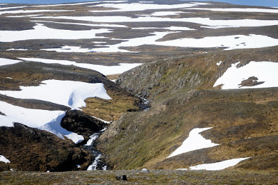
I'm not often flummoxed by landforms, but I have found one that is seriously confusing. It's on the north slope of Preseli, on the area labelled as Banc Llywdlos, at grid ref SN093325. It's a faint armchair-shaped hollow in the hillslope, so subtle that I have never even noticed it from a distance, and I literally stumbled across it as I was traversing the hillside. It's so subtle that it does not show up on the contour maps, and it is very difficult to see on the satellite imagery as well. It's also virtually impossible to photograph, except maybe with a very low sun in the winter -- but because it is on a north-facing slope it's often in shadow in the cold part of the year.
The dimensions are approx 175m from one flank to the other, and c 150m front to back. The altitude of the back edge is c 396m and the front edge is at c 350m. It looks straight down on the large fenced enclosure that contains water supply springs -- this is shown on the 1:25,000 Explorer map.
Hereabouts on the mountain slope the vegetation is wet grassland, but inside the amphitheatre it is even wetter, except for a debris tongue which is marked by bright green grass -- this emanates from a cut towards the upper edge of the "cwm". The undulating ridge that runs across the mouth of the cwm is much drier, and that is cut into by a number of small gullies, the westernmost of which has a discernible debris tongue beneath it. To the east of the debris tongue within the basin there is a prominent mound, which has a number of dolerite boulders embedded.
My first instinct was that this feature is a landslide scar caused by slope failure, but the distinct ridge across its mouth does not make sense -- a real debris flow or landslide would have carried debris much further downslope. There are two discernible small debris flows, but the creation of the little basin must be down to a different process entirely. Which brings me to the process called nivation, which operates at a very small scale and at a slow pace in locations where permanent snowpatches exist. Well, this is a perfect place for perennial snowpatches during cold episodes -- facing directly north, with en extensive undulating plateau above to guarantee a supply of wind-drifted snow. So this is my best guess -- the ridge across the mouth of the feature may have accumulated very slowly -- maybe over a couple of thousand years, by winter freeze-thaw (and rock breakage) and then sapping and meltwater flow beneath a permanent snowpatch. This is at a completely different scale than the formation of cwms or corries formed beneath small mountainside glaciers. In these, the processes can of course be referred to as "glacial" without any risk of disagreement among experts! The small debris tongues and gullies have come later as the feature has been modified -- probably during periods of exceptionally heavy rainfall and super-saturation of the ground surface.
I think that this feature lies above the upper limit of the Irish Sea Glacier in this neighbourhood (I have assessed that as 340m) -- but it is not beyond the bounds of possibility that the ridge across the mouth of the little basin is actually an ice marginal moraine rather than something generated by a snowpatch.
So there we are then. It will be good to know what others may think....


No comments:
Post a Comment
Please leave your message here