THE BOOK
Some of the ideas discussed in this blog are published in my new book called "The Stonehenge Bluestones" -- available by post and through good bookshops everywhere. Bad bookshops might not have it....
To order, click
HERE

Monday 28 January 2019

The Rhosyfelin "monolith extraction point" -- exposed as a fantasy


On this blog we have devoted much space to detailed examinations of the claims by Prof MPP that he knows where one of the bluestone monoliths at Stonehenge came from.  Namely, from a little crack in the rock face near the tip of the Rhosyfelin spur, close to the point at which Ixer and Bevins claim to have found their "Jovian fabric" in foliated rhyolite bedrock.  Check out these links:

https://brian-mountainman.blogspot.com/2018/04/that-famous-monolith-extraction-point.html

http://brian-mountainman.blogspot.co.uk/2015/09/rhosyfelin-some-geological-questions.html


The "monolith extraction point" never did stand up to scrutiny, for a variety of different reasons enumerated in the blog posts -- but so keen was MPP to demonstrate the reliability of his pronouncement that he took samples for cosmogenic dating from this exact location.  This was back in 2016..........  Since then there has been complete silence, although the samples must have been analysed long since.  If there had been anything in the way of verification, MPP would certainly have published the dates by now, or mentioned them in his lectures.  He has done neither.  That means that the dates must have falsified his theory -- but why does he not behave like a proper scientist and come clean about it?  After all, in the world of academia negative results are as important as positive ones.

Yet another example of how desperately poor is the case of quarrying at Rhosyfelin.

Sunday 27 January 2019

Archaeology on the Byers Peninsula --or maybe not.......


During the last few weeks of 1965 David Sugden and myself, accompanied by a botanist and a zoologist, camped in the snowy wastes of the Byers Peninsula, at the western end of Livingston Island in the South Shetlands island group.   We were employed by the British Antarctic Survey, and our South Shetlands project (looking at raised marine features and phases of glaciation) was one of the major field projects of the 1965-66 summer season.   It was supposed to be high summer, but we had frequent snowfalls and even blizzards during our time there, following an unusually snowy winter and spring.  We saw enough of the raised beaches and other geomorphological features to get an ambitious work programme completed  but it was tough, working in such a bleak and beautiful place for the whole of December without any backup at all, and with only intermittent radio contact with the outside world.   Our base camp was located near the eastern extremity of South Beaches, because the captain of RRS Shackleton, the BAS support vessel, refused to land us and our supplies further to the west.  That meant long slogs on skis into our main research areas, and many subsidiary camps which were occupied for just a few days at a time.

This brings me to a new map showing "archaeological sites" on the Byers Peninsula. Because the Byers Peninsula is the largest ice-free area in the South Shetlands island group, it was heavily used by sealing parties hunting for fur seals and elephant seals between 1820 and 1822 -- even though the islands were not discovered till 1819.  Both American and British sealing fleets operated around the shores of the islands, with upward of 100 vessels used each summer.  Many vessels took home cargoes of more than 70,000 skins, and it is estimated that over a million animals were killed -- and by 1823 the fur seal on the islands was extinct.  It was one of the greatest and fastest animal extinctions in history.  Fifty years later the fur seals had recovered some of their lost territory, but in the 1870's American sealers returned, and within a few years all of the fur seals were exterminated again. 

Gradually the fur seals are returning.  In 1965 - 66 we made several sightings of the animals on the fringes of vast colonies of elephant seals, and since all the seals are now protected re-colonisation proceeds -- albeit at a very slow pace.

There are no proper records of the sealing operations, but they were commercially competitive and shrouded in secrecy, and the best sealing beaches were jealously protected.  Occasionally, there was open conflict, and shore parties were occasionally abandoned by captains who had little respect for human life.  Records suggest that at the end of each sealing season the killing and processing shore parties left behind them scenes of almost indescribable horror........

There is a now a great interest among Antarctic historians in the South Shetlands sealing operations, and this is one of a number of recent publications: 

https://www.researchgate.net/publication/259935179_Living_in_the_cold_Geoarchaeology_of_sealing_sites_from_Byers_Peninsula_Livingston_Island_Antarctica

Living in the cold: Geoarchaeology of sealing sites from Byers Peninsula (Livingston Island, Antarctica)
November 2013
Quaternary International 315(27):184-199
DOI:   10.1016/j.quaint.2013.07.001
by Ximena S. Villagran, Carlos E.G.R. Schaefer, Bertrand Ligouis

This paper concentrates on two sites near the western end of South Beaches -- and the researchers have uncovered fascinating evidence of how the shore parties lived, and how they worked during the killing seasons.  I have no doubt at all that their records are authentic and valuable.


But then I looked at this map of "archaeological sites"-- and decided that some of the locations marked look remarkably familiar! I am pretty sure that some of them are our 1965-66 camp sites, marked by circles of stones (brought in to place on our pyramid tent vallances so as to stop them from taking off during storms).  At our base camp we had five tents in a cluster -- so that means five circles of heavy stones or boulders.  In addition, at this site and some others we had to build "stone walls" or lines of boulders designed to keep elephant seals at bay -- since some of the young bulls thought it would be quite pleasant to lie on top of a flattened tent (regardless of whether there were people inside) instead of on a mucky and stony beach.  Then there were toilet pits and rubbish pits -- some of which can still be traced in the landscape -- and small piles of stones or cairns used for keeping primus stoves and other items off the snow-covered or slushy ground.  In short -- lots of "habitation" traces which could easily be mistaken for nineteenth-century sealers' encampments.

All good fun.  It's quite jolly to have been personally responsible for things referred to as "archaeological features" -- and we should maybe feel some sympathy for the archaeologists who have made big mistakes rather closer to home with regard to stone circles and cromlechs.

How to stop a pyramid tent from taking off......... and afterwards, when you are long gone, a nice arrangement of boulders is left behind.

Elephant seals and Byers Peninsula base camp in the middle distance


Thursday 24 January 2019

Nice map -- not much evidence

This is an attractive map from a very detailed and technical chapter on glacigenic sediments by Prof Dave Evans. Caption: "map showing major ice flows (at the time of the Devensian or LGM) onto the continental shelf (from Ó Cofaigh et al. 2012)".  Very generalised, I know, but........ on the east side of St George's Channel it bears no relationship to the evidence on the ground.  I know the Pembs coast pretty well, and all of the Devensian exposures, and I do not know of any evidence that shows that the ice moved from NE towards SW.  The arrows are 90 deg out from where they should be.  ALL of the evidence that I am aware of shows that the LGM ice flowed from NW towards SE. 

Whose fault?  Colm O'Cofaigh and his colleagues?  More care needed in future please, chaps......... 

Chapter 4 Conceptual glacial ground models: British and Irish case studies
D. J. A. Evans. 
In:
Geological Society, London, Engineering Geology Special Publications, 28, 369-500, 2017, 
"Engineering Geology and Geomorphology of Glaciated and Periglaciated Terrains – Engineering Group Working Party Report"

Monday 21 January 2019

The joy of follies

Gosford House (1790-1800) from the air.  The follies are found in the woods and in the landscaped grounds behind the house, which looks out towards the coast.

I have this little theory -- explored on previous occasions on this blog -- that powerful men who have the resources (in raw materials and manpower)  will often seek to impress their neighbours by building strange structures which have only the slightest connections with the utilitarian (or spiritual) world.  We can call them works of art if we like -- but some are really rather entertaining, and are clearly designed not just to impress but also to make people gasp or smile.  Stonehenge might well be one such building, but follies came much more into fashion in the 1700's and 1800's, especially on the grand estates of the landed gentry.

During a short visit to Scotland we visited Gosford Estate in East Lothian, very close to the coast of the Firth of Forth. the grand house (designed by Adam and much modified in the nineteenth century) is hugely impressive, but the assorted follies are -- in a bizarre fashion -- almost as impressive!  Here are a few of them:


The pyramidal mausoleum (1795), which apparently only has two people buried in it. A lot of Masonic symbolism was built into the design.

The bathing and boating house (c 1840?)  on the shore of an ornamental lake. A hugely impressive structure, completely out of proportion with the size of the lake or indeed the size of any boats likely to have been used on it.

Another view of the bathing and boating house. Maybe the ladies and gents bathed within it, away from the prying eyes of the servants?

The curling house, used in the mid-1800's by a local curling club, in the days when the lake froze over in the hard winters of the time.  It's on the shore of the ornamental lake.  The rough blocks from which it is made are of heavily weathered and pitted local limestone.

The grotto or ornamental front of the ice house (late eighteenth century?).  It is also called a shell house, but the frontage is made with thousands of pebbles, not shells.

Another jolly hoax


The Leochel-Cushnie stone circle in Aberdeenshire, which turns out to be around 20 years old.  


Followers of this blog will be familiar with the Neolithic Quarrying hoax perpetrated by Mike Parker Pearson and his merry band of diggers -- as covered here:

https://brian-mountainman.blogspot.com/2018/11/the-bluestone-quarries-best-hoax-since.html

Now comes another one -- this from from Scotland, and relating to a supposedly Neolithic stone circle:

https://www.bbc.co.uk/news/uk-scotland-north-east-orkney-shetland-46946652

'Ancient' Aberdeenshire stone circle found to be replica

An Aberdeenshire stone circle initially thought to be thousands of years old has been identified as a modern replica.
An investigation into the site at the parish of Leochel-Cushnie found the stones to be about 20 years old.
It was originally thought to be the site of a recumbent stone circle - until the man who built it came forward.
The findings sparked excitement among experts and were widely reported.
They were initially celebrated as an authentic recumbent stone circle by Adam Welfare of Historic Environment Scotland and Aberdeenshire Council's Archaeology Service.
Further archaeological analysis of the stones was being conducted when a former owner of the farm contacted Mr Welfare to say he had built the stone circle in the 1990s.


'Great feature'
Neil Ackerman, historic environment record assistant at Aberdeenshire Council, said the development was "disappointing", but hoped the site would still be appreciated.
He said: "I hope the stones continue to be used and enjoyed - while not ancient it is still in a fantastic location and makes for a great feature in the landscape.
"These types of monument are notoriously difficult to date."
Recumbent stone circles were constructed about 3,500 to 4,500 years ago and are unique to the north east of Scotland.
Their defining feature is a large horizontal stone flanked by two upright stones, usually situated between the south-east to south-west of the circle.

It's not certain that the farmer who built this stone circle intended to fool anybody, but the archaeologists have certainly got egg on their faces......... the farmer probably just thought he would have a bit of fun and lighten up the miserable lives of the gullible masses.

Of course, we have a similar "replica" here in Pembrokeshire, on land belonging to the Brithdir Community -- and used for assorted mysterious ceremonies.  In the Brithdir case, the builders of the circle do claim that at least some of the stones were recumbent, and that there was something significant before all their stone-setting work started........

So when is a hoax a hoax?

The modern stone circle at Brithdir Mawr, near Newport in Pembrokeshire

Thursday 17 January 2019

Penfro Formation -- a lexicon correction needed

A type locality for the Penfro Till Formation?  Cemented till exposed at Black Mixen, Lydstep.


A type locality for the Penfro Till Formation?  Cemented and stained till near the coast at Ceibwr, overlain by cemented glacifluvial gravels and fresh grey-blue till.

I have sent this message off to BGS with a view to getting the lexicon record corrected, with respect to the Penfro Formation.    I don't object to the name -- some name has to be used for the ancient till deposits, and "Penfro" is as good a name as any.  But the record is misleading since neither West Angle nor Llandre should be used as a type location.

So what are the candidates for type localities?  I am suggesting Ceibwr and Black Mixen (Lydstep) since these are the two sites where an old cemented till can be seen in close proximity to a fresher till.  Other sites are Witches Cauldron and Whitesands -- but I need to do some more checking at both......

We'll see how we get on.  It would be good to visit the sites in the company of a BGS geologist, if we can organize that.

Penfro Till Formation.
https://www.bgs.ac.uk/lexicon/lexicon.cfm?pub=POTI


I cannot work out where the type locality is supposed to be.  Is it Pencoed?
The two "partial type sections" referred to are highly misleading, and should be removed from the Lexicon.  West Angle does NOT reveal an ancient till (Penfro Till) beneath the raised beach.  Both Dixon and Bowen have misinterpreted the stratigraphy.  There is a till at the site, but it is of late Devensian age, and rests ABOVE the silt and clay series assumed to be interglacial.  Llandre is a useless site too -- there are apparently glacifluvial gravels there, but there are no stratigraphic markers that can be used to tie in with any regional stratigraphy.

The only two convincing sites where an ancient till can be seen in close proximity to a more recent till are Black Mixen (Lydstep) and Ceibwr.  Please use these as type localities instead.  What is the process for correcting the lexicon?

https://brian-mountainman.blogspot.com/2017/03/the-west-angle-enigma-3-two-tills-or-one.html

https://brian-mountainman.blogspot.com/2018/05/lydstep-ancient-till-site-confirmed.html

https://brian-mountainman.blogspot.com/2017/02/llandre-gravel-quarry-where-is-penfro.html

https://brian-mountainman.blogspot.com/2019/01/ceibwr-quaternary-stratigraphy-and_9.html

Wednesday 16 January 2019

The curse of lithostratigraphy


I have spent a great deal of time on this blog celebrating stratigraphic correlations and stressing their importance in understanding what happened during the Quaternary in West Wales and in SW England in particular.   These are just a few of my posts:

https://brian-mountainman.blogspot.com/2015/12/quaternary-stratigraphy-in-pembrokeshire.html

https://brian-mountainman.blogspot.com/2014/01/the-joy-of-stratigraphy.html

https://brian-mountainman.blogspot.com/2017/02/the-west-angle-enigma.html

https://brian-mountainman.blogspot.com/2016/09/rhosyfelin-in-its-regional.html

https://brian-mountainman.blogspot.com/2016/09/devensian-stratigraphy-of-south-west.html

https://brian-mountainman.blogspot.com/2018/10/abermawr-new-quaternary-stratigraphy.html

Without stratigraphic matching and comparisons, we would not be able to work out common histories of events and environmental conditions -- but there are limitations and even dangers that we should be aware of.  There are different sorts of stratigraphies -- and we have already, on this blog, bemoaned the fact that our understanding of the Quaternary in Wales has probably been set back by decades by this weird thing called "aminostratigraphy" -- involving the correletion of layers of sediment in different locations according to the "amino acid ages" given to contained in shell fragments.  When you do that sort of thing with an immature dating technique, you are asking for trouble --and in Wales we have had trouble in bucket-loads........

When we talk of "lithostratigraphy" we are on safer ground -- after all, this is the basis of most solid rock correlation and dating, although fossil content, geomagnetic signatures and degree of metamorphism are among the other factors used by geologists in sorting out (for example) the Permian from the Pre-Cambrian.  Here is the Wikipedia definition:

The lithology of a rock unit is a description of its physical characteristics visible at outcrop, in hand or core samples or with low magnification microscopy, such as colour, texture, grain size, or composition.  It may be either a detailed description of these characteristics or be a summary of the gross physical character of a rock.  It is the basis of subdividing rock sequences into individual lithostratigraphic units for the purposes of mapping and correlation between areas. In certain applications, such as site investigations, lithology is described using a standard terminology such as in the European geotechnical standard Eurocode 7.

In Pembrokeshire the lithology of a rock if often a simple indicator of where it lies in the sequence. Even the least experienced geologist can differentiate between the red sandy rocks of the Old Red Sandstone, the fossiliferous grey limestones of the Carboniferous Limestone, and the black shiny anthracites of the Coal Measures.  Most can see the differences between igneous and sedimentary rocks, although metamorphics can be more difficult.  But when it comes to shales and  mudstones, most of us would have difficulty in differentiating, in hand specimens, between Ordovician samples from Ceibwr and Millstone Grit samples from near Haverfordwest.

When it comes to the Quaternary, things are also very difficult, since different events or climatic / environmental conditions will give rise to deposits with similar lithologies or appearances but with widely differing ages (an old stratified slope deposit might well look very similar to a fresh one).  So it might be difficult to sort out what is what unless there are very clear stratigraphic sequences on display which can be used for lateral correlations.  The Devensian Irish Sea till, for example, always occurs in the same stratigraphic situation (where we can see it) but it differs markedly in its physical characteristics, from one place to another, depending on what the "parent material" might have been, and depending on the glaciological conditions that obtained at the time of deposition. In cases like this my own instinct is to minimise the number of lithostratigraphic labels I use, since it would not help anybody if I was to refer to the Abermawr till, the Druidston till, the Newport till and the Gwbert till (and many others) by different names.  When I was writing my doctorate thesis in 1965, I tried always to refer to the Irish Sea till, but I did qualify that by referring to two sub-categories -- the coastal facies (made mostly of marine muds containing sea shells)  and the land facies (made largely of locally derived rock fragments in a sandy and silty matrix). 

So to the bigger problems, and to the reason for my use of the word "curse."

Unfortunately there are some geomorphologists who have made a specialism out of making lithostratigraphic correlations and publishing an endless stream of "lithostratigraphic regional and national correlations" in which the correlations keep on changing.  Confusion reigns, in a certain section of the specialist literature.  Prof DQ Bowen has probably published more than anybody else in this field, and some of the terms he has applied to some of the deposits have, as far as I know, never been used by anybody else.   However, in some cases, because he is the "specialist", others have deferred to him and his work,  without first checking carefully on reliability.  So we have the use of these terms:  formations, members and beds.  That's all very fine, and conforms to geological good practice, but it gets a bit mystifying as far as Joe Public is concerned.  In SW Wales we find things labelled as belonging to the St Asaph Formation and the Elenid Formation (correlated with Oxygen Isotope stage 2) and then lower in the sequence the Penfro Formation (correlated with OIS 16).  

I have referred to the Penfro Formation before, and have expressed strong concerns about its reliability as a label:


https://www.bgs.ac.uk/lexicon/lexicon.cfm?pub=POTI

If we look at the definitive entry for this "ancient till"  in the BGS lexicon, under the Albion Glacigenic Group as the "parent unit", we find that the type localities are West Angle Bay and Llandre Quarry in Pembrokeshire.  That is an extraordinary error on the part of the geologists, since there is NO ancient till exposed at either site, and the sands and gravels at West Angle are demonstrably Devensian -- and therefore have nothing to do with the Albion Glacigenic Group. 


The critical central part of the West Angle exposure.  Here we see the erosional contact between the older deposits (partly interglacial) to the south and the younger (partly glacial) deposits to the north.  Dixon, Bowen and others might not have seen this contact clearly, and so they assumed (erroneously) that some glacial deposits are older than the grey silt and clay series.

 There are admittedly some glaciofluvial gravels at Llandre that might be old, but neither DQB nor anybody else has ever published a full description of them, and there is nothing at the site to tie the gravels into a regional sequence.

Type localities need to be stable, accessible and clearly tied into a regional stratigraphy.  Llandre is useless as a type locality for anything;  if West Angle is used as a type locality for anything, it should be for the Devensian or the Ipswichian, and most definitely not for the Penfro Formation or the Anglian glaciation.

Then we come to another problem of lithostratigraphy.  Once somebody has studied a region in detail and published what might be deemed to be "definitive" studies of the sedimentary sequence, with "formation" or "member" labels attached,  and type localities identified, there is a tendency for those labels to be over-used or applied in a non-critical fashion.  I became very much aware of this during my short visit to the Isles of Scilly a couple of years ago, as I looked at innumerable coastal sections on all of the main islands.  In a QN article I described and interpreted the deposits as best I could, given the limitations of time and resources:

https://www.researchgate.net/publication/328413421_Evidence_for_extensive_ice_cover_on_the_Isles_of_Scilly/figures?lo=1

Right from the start, I had problems in fitting the sequence and the characteristics of the deposits into the stratigraphic sequence devised by James Scourse in 1991 and subscribed to (with minor modifications) by others since then.  There were two problems, one relating to the choice of type localities, and the other to the choice of stratigraphic labels.  I had problems with the "Watermill Sand and Gravel" on the basis that Watermill Cove is not a very good type locality and that the raised beach sediments are neither sandy nor gravelly.  I had problems with the "Scilly Till" type locality at Bread and Cheese Cove since the till there is associated with glacigenic structures which are not all that widespread and since other till exposures elsewhere are perhaps more typical of the northern fringes of the islands.  The "Porthloo Breccia" I can live with, in that it is always in the same stratigraphic position and since Porthloo is a good type locality.  I had problems with the "Tregarthen Gravel" and the "Hell Bay Gravel"  labels since they did not seem to have consistent characteristics and since some exposures were not at all gravelly.  The labels seemed to me to be surplus to requirements.  I was not too sure about the "Bread and Cheese Breccia" either,  since in places it had exactly the same characteristics as the Porthloo Breccia.  And neither was I sure about the "Old Man Sandloess" since it too had rather variable characteristics from one exposure to another. 

 
Clay-rich till exposed at Chad Girt, in a rocky gully on White Island, Isles of Scilly.  Should this be called "Scilly Till", or something else.....?

In my QN paper I used these Scourse terms sparingly, just where I thought they might help in understanding the stratigraphic sequence -- but I have been heavily criticised for occasionally placing the deposits I observed into the "wrong" category in the "accepted lithostratigraphic sequence" !!  Hmmm.  As far as I am concerned, I have not accepted anybody's sequence, and will not accept any sequence unless it seems to me to be either accurate or useful.  In ice wastage environments depositional circumstances -- at exactly the same moment in time -- from place to place can vary enormously, and that needs to be recognized.   It is a singularly fruitless exercise to become worked up about the application -- or non-application -- of predetermined labels when the only questions worth asking  are these:  What happened?  And when?

Hence my scepticism about lithostratigraphic labelling.  There are bad labels, and bad type localities.   If we become obsessed by labels and type localities, we can easily be dragged into a scenario in which we "force" the sediments we find into predetermined boxes -- and in the process lose scientific objectivity.  If labels are worth using, they will survive.  If some of them are causing more trouble than they are worth, they should be dumped.


Tuesday 15 January 2019

UK Quaternary Domains


This is an interesting report, which outlines how the geologists of the BGS have gone about defining the details of British Quaternary stratigraphy -- using the same principles as they do for solid rock units. They are, after all, geologists and not geomorphologists..........  

ENTWISLE, D C, WILDMAN, G. 2010. Creation of the Till Thematic Layer. British Geological Survey Internal Report, IR/10/041. 14pp.


The pap above is a very interesting one  -- designed to appeal to a geographer like me!  It's a sort of landscape regions map, but with Quaternary surface characteristics and sediments added.

One thing of interest is the apparent acceptance of the BGS geologists that the Anglian ice pressed against the coasts of Somerset, Devon and Cornwall all the way from Weston super Mare to the Isles of Scilly.  So they must accept the presence of Quaternary sediments and landscape features all the way along the cliffline.  That is, of course, in tune with what many geomorphologists have said over the years, although there are many others (frequently cited on the pages of this blog) who vehemently disagree and who claim that the Anglian ice edge was located somewhere far to the west in the outer reaches of the Bristol Channel or in the Celtic Sea. (This latter view looks more and more untenable, especially as evidence accumulates for a Devensian Irish Sea Glacier that pushed far to the south of the Isles of Scilly.)  So the Anglian ice edge as shown on this map appears, in some places at least, to coincide with the position of the Devensian ice edge.

It follows that the Devensian ice limit, as shown for Wales on this map, has to be very unreliable indeed.

I'll shortly do another post on this, and on the Penfro Till Formation (supposedly of Anglian age) which the BGS lists in its lexicon, apparently on the basis of very dodgy evidence supplied by Prof Dai Bowen.

Here is another useful BGS Report:


http://nora.nerc.ac.uk/id/eprint/3241/1/RR04004.pdf

MCMILLAN, A A, HAMBLIN, R J O, and MERRITT, J W. 2005.
An overview of the lithostrati- graphical framework for the Quaternary and Neogene deposits of Great Britain (Onshore).
British Geological Survey Research Report RR/04/04 38pp.


This map shows the glacigenic groups in Southern Britain, including the "Abion Glacigenic Group" outside the putative Devensian limit and the "Caledonia Glacigenic Group" within the Devensian limit.  The proto-river pattern is much discussed.  Note that the ice of the Anglian Glaciation is assumed to have affected both shores of the Severn Estuary, as far out as Flatholm, Steepholm and Brean Down.


You can see the relationship between the maps above and the "traditional" map showing ice edges and glacier flowlines -- after Boulton, Wright, Zeuner and many others.  The "Older Drift" / "Newer Drift" distinction is of course perpetrated by the use of maps such as this.  in reality, as ever, things are much more complicated than the maps suggest......

Wednesday 9 January 2019

Ceibwr -- Quaternary stratigraphy and related events (2)


Further to my earlier post about the exposures now to be seen at Ceibwr, here are some more photos, from the flanks of the rocky spur that separates Channel 1 from Channel 2.  Again, no complete sequence is to be seen, but at the northern tip of the spur we can again see TWO tills of different ages, one of them solidly cemented and the other fresh, separated by stained and bedded gravels:


Sediments resting on an abraded rock surface, parts of which are still affected by waves during extreme storms coinciding with high tides. The rock surface, cut across thin-bedded shales, is at bottom left.  Resting on it is a stony deposit with cobbles and larger erratics which is interpreted as an ancient cemented till.  It is stained by iron oxide and manganese oxide cement, and has a slightly purple tint in its colouring. Above it we see fine-grained glaciofluvial gravels with a foxy red or brown colouring.  the gravels contain occasional larger cobbles.  The grey-blue uncemented till seen beneath the turf to the right of the photo is clearly younger than the stained and cemented deposits.


Close-up of the youngest (uncemented) till deposit, showing relatively stone-free Irish Sea till at the base, with a more stony layer above (at the position of the trowel), and a sandy and silty colluvium / sandloess close to the ground surface.


Close-up of the cemented stratified gravels in the same section, with traces of what might be frost "churning" under permafrost conditions and possible ice-wedge casts.  Alternatively these may be primary sedimentary structures, related to downslope flows of saturated materials in a dead-ice environment.


In a separate exposure just a few metres away, we see cemented till at the base, capped by a manganese oxide cemented hardpan, with foxy-red glaciofluvial gravels above.  Then, above a sloping erosional contact we see fresh blue-grey till and colluvium -- apparently redeposited and mixed up by downslope movement.


The deposits described above rest on this wave-washed platform.  It is difficult here to distinguish modern erosional features from old ones -- but abraded surfaces do seem to pass beneath the deposits.


Exposure on the eastern flank of the rocky spur, showing pseudo-stratified slope breccia made of local mudstones, beneath fresh and uncemented grey-blue till.  Slope deposits are found in the exposures only in locations where there are adequate upslope outcrops of solid rock and a steep gradient.  This is an indication that periglacial or permafrost conditions preceded the arrival of glacier ice at this location -- exactly as seen at many other North Pembrokeshire sites.


River cutting upstream from the footbridge, in the main Ceibwr valley.  Cemented foxy-red gravels are seen here beneath blue-grey till with abundant clasts derived from local slope breccias.


Steep-sided channel 2.  The rocky spur is on the right.  Note the rock-cut slope near the cars.


Apparent meltwater erosional features beneath an overhang on the flank of the rock spur.  The location is near the white vehicle shown in the above photo.  The smoothed rock surfaces have been damaged by subsequent weathering processes, suggesting great age.


I think it's important to get these images onto the public record, since this is going to be a very important Pleistocene site.  Overall, the stratigraphy is confirmed as follows:

Modern soil -- c 20 cms. Uncemented
Sandloess and colluvium -- c 50 cms. Uncemented. Holocene?
Clay-rich Irish Sea Till -- up to 2 m thick. Blue-grey colour.  Uncemented. Late Devensian?
Brecciated slope deposits -- up to 50 cms thick. Uncemented.  Early / Middle Devensian?
Clay-rich colluvium -- c 20 cms thick. Uncemented but stained / gleyed. Ipswichian interglacial?
Glaciofluvial gravels -- c 1.5m thick. Stained and cemented. Foxy red colour.  Anglian?
Stony till -- up to 1m thick. Stained and cemented by iron oxide and manganese oxide precipitates. Foxy red / purple / black colouring.  Anglian?
Brecciated slope deposits -- up to 1 m thick.  A pre-glacial Anglian phase?

Note that there are no traces here of the raised beach (Ipswichian) which we see at Poppit, Abermawr, Porthclais and many other locations. 

Further work is needed on the abraded rock surfaces which are exposed by occasional storm wave assaults at the exit of Channel 2.  Are these surfaces ice-moulded?  Are they simply old channel floors cut largely by meltwater erosive forces?  Or are some of them -- at various altitudes -- affected by present-day and ancient coastal processes?


Flattish rock surfaces, eroded across dark Ordovician mudstones, at the head of the Ceibwr tidal creek, near the limekiln.  Are we looking here at the bed of the meltwater channel, or are present-day coastal processes responsible?  However these surfaces have been cut, it seems that the sediment fill in the channel, between HWM and LWM, is not more than a few metres thick.


Monday 7 January 2019

"Till boulder" on James Ross Island


Now for something completely different -- a boulder made of "diamictite" (let's call it till) in a boulder train on James Ross Island, Antarctica.  It did not fall onto a glacier surface, and so it must have been excavated by over-riding ice in a deeply frozen state -- and then transported rather delicately by the glacier........

I have never seen this phenomenon before!  Further info here:
http://www.antarcticglaciers.org/glacial-geology/glacial-landforms/glacial-landsystems-on-james-ross-island/#jp-carousel-5863

Glacier front geomorphology


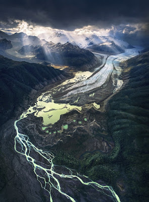
Click to enlarge.  This is one of the most fabulous images I have ever seen of a receding glacier front.  (I don't like referring to a "retreating glacier" since glaciers do not turn round and go marching back up the valleys whence they came.......   They keep on moving forward, but when the rate of melting on the surface and at the snout exceeds the forward movement, then they have a problem.......)

There is no point in trying to describe everything visible in this image -- but there is a whole course in glacial geomorphology captured here.

I don't even known where this photo was taken -- but I suspect it might be somewhere in Patagonia.

Friday 4 January 2019

Ceibwr -- Quaternary stratigraphy and related events (1)

Following recent visits to Ceibwr, I think I'm getting the story sorted out at long last.  It's not easy, since there is no single location where the full sequence of sediments can be seen.  There are more than a dozen exposures in and around the bay, so extrapolations are necessary.......

These are the key locations:

SN107457  --  roadside exposures of cemented glaciofluvial gravels

SN107457  --  gully with potholes (channel 3) near coast

SN108457  --  largest exposure of cemented gravels etc -- near tip of spur

SN110456  --  plug of Irish Sea Till and other deposits in mouth of valley (Channel 1)

SN109456  --  intake for Channel 2 (hump)

SN108456  --  meltwater erosion traces on rock wall of Channel 2

SN109456  --  hummock of fresh glaciofluvial gravels filling entrance to Channel 2

SN110455  --  riverside exposure -- cemented gravels beneath Irish Sea Till

Herewith a photo gallery with annotations in roughly the order of the list above. We concentrate here on the features in and around the Ceibwr Gully -- I'll deal with the other exposures in a later post.


Roadside exposure.  Approx 1m of cemented iron-stained glaciofluvial gravels with horizontal bedding, resting on vertical strata of Ordovician shales.  A classic unconformity........


Roadside -- cemented gravels.  Here they appear to be plastered against the side of the shale bedrock ourcrop.  The location is about 10m above the floor of Channel 2, which we see at the right edge of the photo.   It's most reasonable to propose that the gravels were emplaced by water flowing along an ice edge, at a time when the channel was filled by wasting ice.


A second exposure of horizontally bedded gravels, a little way uphill.  These are also solidly cemented, but the exposed surface is covered with mosses and lichens.


The small gully (Channel 3) with potholes, on the western flank of the exit of Channel 2 where it reaches the coast.  The potholes contain many large submerged erratics, including some that are far-travelled, of igneous origin.


Rock surface on the flank of the gully, showing classic pothole erosional features and surface staining by iron and manganese oxide.


This might just be the oldest Pleistocene deposit ever recorded in Wales.  It's a cemented slope breccia, high on the western flank of Channel 2, with the gully (Channel 3) directly below.  The gully may or may not be younger than the deposit -- more investigations are needed.  There is no stratification here -- this is a typical rockfall or slope collapse deposit, which probably has nothing to do with frost processes or periglacial conditions.  The cemented till and cemented gravels lie ABOVE this deposit.


In the same exposure, above the gully, we see TWO tills of vastly different ages.  The lower till is cemented, and is most reasonably interpreted as of Anglian age. Above that we see stratified glaciofluvial gravels, also cemented -- with several different facies.  Above that, uncemented grey-blue clay-rich till with many of the characteristics of Irish Sea Till -- probably of Devensian age. This is a hugely significant photograph -- I need to visit the site again in the company of other Pleistocene specialists.......


Remnants of cemented slope breccia with erratics (ancient till?), at the water line within one of the potholes. The gully might  have been cut -- or at least enlarged -- in the Anglian glaciation, before the deposition of the concreted till.


Close-up of the concreted till (Anglian?) on the slope above the gully.  It incorporates broken slabs of local bedrock, a wide range of erratics (including igneous rock types), and cobbles and pebbles of many different sizes.  Some of these rounded stones have been glaciofluvially transported, and some may even have been derived from raised beaches that are now destroyed.   The deposit is matrix-supported.  This might be a flow-till.


Above the glaciofluvial gravels, near the end of the trowel handle, there is a layer of clay-rich colluvium up to 20 cms thick, stained orange and red by pedological processes, and above that a "churned" layer of slope breccia.


The churned slope breccia deposit, made of shale fragments derived from a rock outcrop immediately upslope.  This deposit is uncemented.


The head of the gully is plugged with c 2m of cemented red-stained till and glaciofluvial gravels (seen here in the lower half of the photo) and grey-blue uncemented Irish Sea till with abundant erratic boulders above.  I'm pretty certain that these deposits represent two distinct glacial episodes.


Above the double till layers we see c 50 cm of sandy and silty colluvium / sandy loam which is elsewhere called Sandloess.  There are occasional erratics within it, probably redeposited from outcrops upslope.   This must have accumulated during the Holocene / post-glacial period.  The modern soil horizon is seen at the top of the section.

On piecing things together, the full Pleistocene stratigraphy here seems to be as follows:

Modern soil -- c 20 cms.  Uncemented
Sandloess and colluvium -- c 50 cms.  Uncemented.  Holocene?
Clay-rich Irish Sea Till -- up to 2 m thick.  Uncemented.  Devensian?
Brecciated slope deposits -- up to 50 cms thick.  Uncemented
Clay-rich colluvium -- c 20 cms thick.  Uncemented but stained / gleyed.  Ipswichian interglacial?
Glaciofluvial gravels -- c 1.5m thick.  Stained and cemented.  Anglian?
Stony till -- up to 1m thick.  Stained and cemented. Anglian?
Brecciated slope deposits -- up to 1 m thick

I need to consult with other geomorphologists on all of this, but I'm pretty sure that this set of deposits ties in rather neatly with the old till / new till situation described from Lydstep:

https://brian-mountainman.blogspot.com/2018/05/lydstep-ancient-till-site-confirmed.html

The cementation process is crucial to the interpretation of these deposits -- are the cemented deposits all very old, and are all of the uncemented deposits relatively young?

https://brian-mountainman.blogspot.com/2018/11/on-significance-of-cementation.html

Next, I must go back to the Witches Cauldron and check out the extremely complicated cemented deposits there.  More clues will undoubtedly emerge.......

I'll do another post shortly on the other exposures at Ceibwr, which broadly confirm the sequence described above.


Thursday 3 January 2019

Ceibwr -- geology and geomorphology


This is a short article written for the Moylgrove Community Newsletter.  I thought it might be useful to reproduce it here, where it will be more accessible to a wider readership........

CEIBWR
Geology and Landscape


Ceibwr is one of the most iconic geological locations in West Wales -- on a par with the Green Bridge of Wales, Carn Meini on Mynydd Preseli, and the Sleek Stone at Broad Haven. Here the focus of attention is the extraordinary cliffline that stretches away to the north-east, culminating in Pen-yr-Afr and Cemaes Head -- but there is a great deal more that deserves our admiration.


First, the nature of the rocks. Here, all of the strata are of Upper Ordovician age, and they are all of sedimentary origin. For the most part they are mudstones, shales and sandstones that were laid down in a deep ocean basin around 458 - 449 million years ago. Sediments were flushed down from a land-mass to the south, and they accumulated in deep water in what was a very dynamic environment, with turbidite flows, slope collapses and sediment fan accumulations. There appear to have been a number of cycles of deposition, with muddy materials laid down first, followed by silts and then sandy layers. If you look carefully, you can see that there is a colour difference between the cliffs on the east side of the bay (where browns and greys predominate) and those to the west (where large portions of the cliffs and stacks are dark grey or black in colour). This is because the Ceibwr Bay Fault outcrops in the eastern cliffs, exposing rocks that are much younger than those to the west. There is a 600 metre “downthrow” of the strata, revealing dark Carreg Bica Mudstones to the west and sandstones and mudstones of the Dinas Island Formation to the east and north. The black mudstones are softer and much more susceptible to coastal erosion -- and this explains why the stacks of Careg Wylan and Careg Yspar are inexorably being denuded by slope collapses and eaten away by the sea.

But it is the structures in these cliffs that are of greatest interest to geologists. We see the strata with striking clarity, but the folds, faults and brecciated or shattered zones in the cliff faces are truly spectacular. In places the strata are standing on end, and elsewhere we see pitching anticlines, synclines and other structures which attest to the power of the mountain building processes that operated here following the closure of the ocean basin in which the sediments accumulated. What we see today is essentially a slice or cross-section through the landscape which is typical of Mynydd Preseli and the rest of north Pembrokeshire. During the Caledonian Orogeny (mountain-building episode), around 400 million years ago, pressure associated with the movements of the continents was exerted from the NNW and SSE, giving rise to parallel anticlines (upland ridges) and synclines (valleys and lowlands) of impressive proportions. The synclines and anticlines in these cliffs are just the small details. Now, almost all traces of the ancient landscape have been eroded away, except for the upland ridge of Mynydd Preseli and its outliers on Carningli, Pen Caer and the northern part of the St David’s Peninsula. The “internal organs” exposed in the cliffs add a special quality to what is already a spectaculatr cliffline with caves, stacks, gullies, rockfall scars and tunnels. And the cliffs are even more spectacular in the distance, where the “harmonic folds” and faults near Pen-yr-Afr are clearly visible.


Ceibwr Bay is really a tidal creek positioned in the mouth of a partly flooded deep valley. The valley is a “misfit” -- far too large to be explained by the work of the small river which is currently in occupation. (It is larger than it appears, because in its lower section -- near the beach -- the rock valley is plugged with glacial deposits more than 20m thick.) Its catchment area, just a few kilometres inland, is not high enough or extensive enough to feed a large river, so the valley as we see it must be an Ice Age relic, formed by glacial meltwater. Like many of the other deep valleys in north Pembrokeshire it may be composite both in age and origin. The valley might well be millions of years old, modified by meltwater at the end of one, two or even three different glacial episodes. The last of these (referred to as the Devensian) was only about 20,000 years ago.

The most interesting feature in the mouth of the big valley is the existence of a small subsidiary valley which is separated from the main creek by a rock ridge. This little valley (in which the car parking area is located) has rock wlls carrying traces of meltwater flow, and a humped long profile, which means that the meltwater that cut it must have flowed uphill before flowing downhill towards the north. Meltwater can only flow uphill when it is flowing inside a pipe, under hydrostatic pressure -- and this can only happen when there is an extensive ice cover across the landscape. Comparison with other valleys (including Cwm Gwaun) suggests that this might have happened about 450,000 years ago and again at the end of the last glacial episode.


Then it gets even more interesting, since at the outer coast there is a gully with three flooded potholes cut into the floor of this western valley -- suggesting another phase of erosion by fast-flowing and turbulent torrents of meltwater. So how do we sort out the ages of these features? There is still work to be done, but the answers probably lie in the sediments within the walls of the big valley (at the head of the creek), the smaller western valley, and the gully. 

  Stratified and cemented glacio-fluvoal gravels (?) at the roadside, about 10m above the
 floor of the channel.

At the side of the road where it goes uphill, on a tight bend, there are two exposures of iron-stained and concreted gravels which appear to be the remnants of a much more extensive gravel deposit which either filled the valley or accumulated against the edge of a melting mass of ice occupying the valley floor. There are other stained and concreted gravels too, at the northern end of the rocky spur which separates the two larger glacial meltwater channels. They are underlain by what appears to be a concreted layer of stony till and overlain by a fresh till deposit and a sandly colluvium containing pebbles and broken cobbles. The till is similar to the Irish Sea Till which is seen at Newport and Gwbert, and in a thick plug at the head of the Ceibwr tidal creek.   There are several discontinuous eposures, and the relationships between the recent deposits are complex. It’s reasonable to assume that the concreted slope deposits, till and gravels are very old (maybe dating from the Anglian glaciation) and that most of them have been eroded away. The fresher uncemented deposits (slope breccia, till and colluvium) probably date from the Devensian glacial episode. But we cannot be sure of this until new dating techniques are used for the measurement of cosmogenic exposure ages on Ceibwr samples.

In this photo, taken near the tip of the rock spur, we see broken bedrock shales at bottom left, with a concreted bed of stony till resting on it.  Above that there is a concreted horizon of finer gravels, with a thin layer of fresh till close to the surface.  This is stratigraphically equivalent to the Irish Sea Till exposed at bottom right, overlain by a silty and sandy layer of "rubble drift" and colluvium.

One final dilemma -- the concreted and fresh deposits also occur in the small gully with iron-stained walls near the outer coast. By implication, this makes the gully very old too, and the two larger meltwater channels even older. There is much still be be discovered here -- but my bet is that Ceibwr will turn out to be one of the most important Quaternary sites in Britain.

Brian John
5 January 2019

=========================

The above is all rather generalised -- I went over to take a look at the sediments yesterday, and will do another post......