THE BOOK
Some of the ideas discussed in this blog are published in my new book called "The Stonehenge Bluestones" -- available by post and through good bookshops everywhere. Bad bookshops might not have it....
To order, click
HERE

Sunday 31 December 2023

Sarsen.org rewrites the laws of physics


The Limeslade Glacial Erratic


In his eternal wisdom, Tim Daw (over on the Sarsen.org blogsite) now seems to be intent on rewriting the laws of physics.   He's on about coastal erratics again.

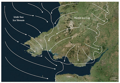
In recent posts he suggests that glacier ice could not have progressed up the Bristol Channel beyond Ilfracombe because the surface gradient on the floor of the channel slopes in the wrong direction. He clearly knows nothing at all about glaciology or glacial geomorphology, or indeed about the laws of physics, because (as I have explained over and again on my blog) ice movement direction id determined by the gradient of the ice surface, and not the gradient of the terrain on the glacier bed. If he reads this, will he please go away and devote a little time to reading some of the geomorphology texts?  For a start, he can get a cheap second-hand copy of "Glaciers and Landscape" written by David Sugden and myself, which was the standard text used in universities around the world for more than 20 years.  He will discover myriad examples where ice has flowed against the land surface gradient -- as for example at the outer ends of almost all the fjords in the world, where the upslope segments are called "thresholds".    Some thresholds involved upslope glacier flow of more than a thousand metres, from -1200 m to around -200m over a distance of less than 20 km.  This not theory.  It is observed and undisputed fact.

https://brian-mountainman.blogspot.com/2017/01/on-uphill-transport-of-debris-by.html

If he is not satisfied with any of that, Tim might also wish to take a look at the field evidence for glacial deposits from the west, in the Bristol area, as described by multiple research workers over the years.  Take for example this:

https://brian-mountainman.blogspot.com/2011/09/ulster-white-limestone-at-kenn.html

Tim then suggests that "icebergs" were responsible for dropping boulders around the coasts of the North Sea, as for example in the freezing weather of 1565, and he provides spectacular and fanciful illustrations in support of his hypothesis.  There were no icebergs in the North Sea in 1565 or at any other time in the Little Ice Age.  Sea ice occasionally formed, and sometimes broken sea ice floes were piled up along shorelines by the force of tides, waves and winds -- some of these accumulations of broken slabs might well have been 6m high.  Some debris might have been moved, since shoreline sea ice in the middle latitudes does sometimes incorporate sand and pebbles as a natural consequence of freezing-on; but to suggest that multiple erratic boulders were redistributed by this process is preposterous, defying the laws of physics.


From Tim's blog -- somewhat fanciful, as we might all agree.......

Next, Tim suggests that the erratic boulders around the shores of the Bristol Channel may all have been emplaced during tsunamis such as that proposed by Haslett and others for the year 1607.  He goes to great lengths to explain that large boulders can be moved by massive turbulent water flow under certain circumstances.  That is true -- I have seen boulders weighing a tonne or more moving in glaciofluvial meltwater rivers on steep gradients at times of peak flow.  But the long-distance transport of boulders by tsunami waves is perfectly nonsensical, and it is misleading to pretend that the 1607 tsunami theory of Bryant and Haslett (2007) is widely accepted.  It is not, and while it is indisputable that there was huge storm damage on the Bristol Channel coasts on 30 January 1607, the consensus is that the damage arose because of an exceptional storm surge.  To quote from Wikipedia:

...........because of high wave energy conditions it is not methodologically possible to distinguish between storm and tsunami boulder deposits on North Atlantic coasts.[17]

In attributing the flood to a storm surge in their 2006 paper,[8] Horsburgh and Horritt show that those proposing a tsunami hypothesis underestimate the volume of water and coastal damage involved in storm surges, and fail to account for flooding on the opposite side of the country on the same day. There is also a lack of evidence for the event affecting West Wales, Cornwall, or southern Ireland. Their tsunami modelling showed that it would not be possible for a tsunami not to affect these areas, while causing flooding elsewhere in the country. Contemporary sources also indicate the flooding proceeded for a period of five hours, which is consistent with a storm surge rather than a tsunami.[8][18]

I agree with Horsburgh and Horritt, and from my intimate knowledge of the coastline of Pembrokeshire I can say that I have never seen anything that supports the idea that there was a gigantic tsunami in 1607 or at any other time that was responsible for refashioning the coastline and redistributing sediments on a large scale.

Time to move away from all these fantasies, Tim, and get real?


Vulnerable areas around the Bristol Channel and Severn Estuary, where storm surges may 
still cause huge damage.


Saturday 30 December 2023

That Kjove Land Giant Erratic


Photo:  Brian John,1962

I found a better version of this image.  It's the most spectacular glacial erratic I have ever encountered in the flesh.  It probably weighs about 2,700 tonnes..........

Dumped on the scattered till plain at the end of the last glacier expansion -- now an area of  dry tundra.  Kjove Land, at the head of Scoresby Sund in East Greenland.

Coastal geomorphology in the Devensian Bristol Channel


 Cliffs of Pleistocene deposits, near Sheringham, Norfolk.  As the sediment cliffs retreat, the storm beach is fed with material derived from landslides / cliff falls.  There is so much redeposited material that the bulk of the cliff face is hidden.


Coastal erosion near Happisburg, Norfolk


Cliffs near Sheringham, Norfolk

What did the Bristol Channel coast look like during the Devensian, when RSL (relative sea level) was low and when ice rafted boulders might have been moved through St Georges Channel following discharge on a floating glacier terminus?

In one of the most wide-ranging and comprehensive studies of high-latitude coastal geomorphology ever published, David Sugden and I attempted to identify the processes at work currently in the polar regions -- and hence the processes that will have operated in the mid latitudes at times of maximum Quaternary glaciation. It was published in the "Progress in Geomorphology" series in 1975.


Types of ice affecting the landmasses and maritime zones in the polar regions. During glacial episodes these zones are expanded and redistributed.

In our review we described the different types of floating ice, making it clear that sea ice (including pack ice and ice floes) is very different from floating glacier ice in icebergs and bergy bits.  In general, sea ice forms on a freezing sea or lake surface and does not carry large erratics and glacial debris.  In icebergs and bergy bits there may be substantial quantities of far-travelled debris  -- indeed, some icebergs incorporating ice from the bed of a glacier may be spectacularly "dirty".  Icebergs tend to "run deep" -- and they generally waste away -- and dump their debris loads -- in deeper water or far out on tidal mud flats.  In contrast, although ice floes may have deep "keels" formed in the same way as surface pressure ridges, they generally float flat, and therefore regularly ride up onto shorelines where they may be incorporated into an ice foot.  In storms they can be driven by a moving mass of floating ice to positions 5m or more above HWM.  Waves generated by iceberg collapse or rolling can also lift and deposit ice masses of all types and deposit them hundreds of metres inland on low relief coasts such as the tidal estuaries of East Greenland or Arctic Canada.

The meaning of all this?  Please don't let me hear any more about large erratics being deposited on rocky coasts by "ice floes"...........


Grounded icebergs in Nordostbugt, East Greenland.  They are stranded in shallow water, but may move again at HWST if there is a change in wind direction.  These are glacier fragments -- some carrying glacial debris including boulders. 


An overturned tabular berg displaying its debris-rich underside


We found this nice little erratic In Kjove Land in 1962.  My mate David Sugden shows the scale.  The boulder was probably dumped by melting ice -- the sea played no role in its transport.


Broken seasonal pack ice (ice floes) in Scoresbysund.  This is a Greenpeace image purportedly showing "glacier ice" and I suppose linked to a climate change agenda -- but they should be more careful with their labelling.


Because, for the whole of the Devensian cold stage, the shoreline was far to the west of the cliff rampart of the Devon and Cornwall coasts, the coastline of the time probably looked much like that of North Norfolk -- with easily eroded cliff faces made of unconsolidated marine, estuarine and glacial sediments constantly changing with minor shifts of sea level, storm surges.  The tidal range will have been smaller than that of the Severn Estuary of today, and there will have been constant inputs of ice-rafted debris.

Was this a permafrost coast with masses of ground ice like those of the coast of Siberia? I doubt that, since in this westerly location the meteorological conditions may well have been too dynamic and changeable.  I know that the BRITICE team have been devoting some thought to this.

 There is a huge variety of sea-floor sediments in the Bristol Channel today, but I am not sure whether it is yet possible to see a coherent sequence of glacial and interglacial sediments.  Watch this space........


Friday 29 December 2023

Devensian shorelines in the Bristol Channel


The BRITICE model for 22 ka -- from Fig 6 of Clark et al 2022.  At this time there was a calving ice front west of Llyn and Anglesey, withy debris laden icebergs capable of carrying erratics through the St Georges Channel and onto the Celtic Sea coasts.  But note that the contemporaneous shoreline was c 50 km to the west of the current Devon and Cornwall coast.

Thanks to the BRITICE - Chrono team, we can now state rather definitively that there could have been no circumstances during the Late Devensian glacial episode which might have led to the ice rafting of large erratics onto the coasts of the Bristol Channel as we know them today.  The modelled reconstructions all show that during episodes of high glacier discharge into tidewater calving fronts, in the Irish Sea, St Georges Channel and the Celtic Sea, the contemporary coastline was well to the west of the current cliffline of the South-West Peninsula -- sometimes between 30 km and 50 km away.

The details:

https://onlinelibrary.wiley.com/doi/10.1111/bor.12594

According to Clark et al (2022) and BRITICE modelling:

31 ka — ice cap over the Scottish Highlands. Ice from outlet glaciers beginning to feed into tidewater floating ice front near Glasgow. Narrow channel near E Irish coast. Most of Irish Sea, Cardigan Bay and Bristol Channel dry land. Coast 50 km or more W of Devon and Cornwall coast. Sea level falling gradually.

30 ka — coast and RSL similar — streaming ice carrying debris into tidewater channel in North Channel area. Ice front now near southern end of North Channel. Bristol Channel dry.

29 ka — similar — ice front now near Isle of Man.

28 ka — no change in RSL and coast position. Calving ice front now near Anglesey.

27 ka — RSL / coast position unchanged. Calving ice front now in St Georges Channel.

26 ka — floating ice front now in Carmarthen Bay and outer end of Bristol Channel. Large ice lobe with minimal surface gradient in Celtic Sea. Partly grounded — isostatic depression from Welsh Ice Cap and ISIS kicks in, and there is a coastal transgression. Coast approaches to within 30 km of present Devon and Cornwall coast. This is the Last Glacial Maximum position. Ice surface over N Pembs at c 1000m. Ice surface in Bristol Channel approx 500m; almost certainly the ice edge was against the cliffline rampart.

25 ka — retreat begins — shoreline static due to approx balance between isostatic depression and eustatic sea level position. (NB modelled ice free enclave in Pembs is an aberration, as recognized by BRITICE team — Pembs was ice- covered.)

24 ka — rapid ice wastage and calving ice front in St Georges Channel. RSL still static.

23 ka — wastage continues. Welsh ice cap shrinks but is still present. Calving ice front W of Anglesey.

22 ka — not much change, but local ice edge retreating in Wales and Ireland. Marine regression — coastline retreats westwards, partly because of isostatic rebound as ice load diminishes. Coast now c 40 km off coast of Devon and Cornwall. Lowest (LGM) sea level stand at -130m

21 ka — marine regression continues — coast c 45 km W of Devon and Cornwall. Welsh ice cap diminishes further, but still in contact with ISIS in N Wales.

20 ka — ice front now near Isle of Man —calving ice stream much diminished. And remnant of Welsh ice cap now isolated — S Wales free of glacier ice. More isostatic recovery — Bristol Channel coast now even further out to W — up to 50 km out from present cliffline. MSL at -125m — gradual rise until 15 ka……….

19 ka — coastal position hardly changed. Welsh ice cap now broken into several small detached ice masses.

18 ka — 16 ka — coastline unchanged. Eustatic rise and isostatic rebound rates approx equal? By 16 ka there is no longer any calving ice front in Scotland, so no feed of icebergs carrying debris.

15 ka — coastal position unchanged — Welsh ice cap gone — just a few small upland glaciers left. Central Valley of Scotland now ice free — Scottish Ice Cap much diminished. MSL at -110m — after 15 ka, rate of rise increases rapidly (meltwater pulse 1A). At 14 ka MSL stands at -80m.

8 ka — all ice now melted. Isostatic recovery slows down and eustatic rise leads to a major transgression — coasts of Devon and Cornwall now near present position of cliffline. MSL at -10m and still rising. At c 7 ka rate of rise slows dramatically — very gradual after that.

=================

It follows that during all earlier glacial episodes during which ice front calving might have occurred, the coastline in the Bristol Channel would have been similarly distant from the positions in which large erratics are now found on the Devon and Cornwall coasts.  Isostatic / eustatic / coastal process relationships would have been broadly similar to those of the Devensian LGM.  Therefore floating ice (icebergs and bergy bits) cannot have been responsible for large erratic boulder emplacement, whatever earlier researchers might have said in the published literature. 

There is no escaping from the conclusion that the big erratics on the coastal platform -- in the current intertidal zone -- must be the remnants of destroyed glacial deposits laid down by active glacier ice during the LGM or one of the earlier glacial episodes.


Thursday 28 December 2023

Happy Christmas and Peaceful New Year to all!


Here's hoping that all who follow this blog, regularly or intermittently, will enjoy a peaceful and happy festive season!  And many thanks for your ongoing support.

Brian

Wednesday 27 December 2023

Quaternary oscillations of the BIIS (British and Irish Ice Sheet)

More and more information is appearing in the literature regarding the events of the Wolstonian - now regarded in some quarters as a more significant episode than the preceding Anglian glaciation.  But it was not a single cold episode -- rather, it was a succession of cold phases separated by slightly warmer interludes.  Isotope stages MIS 10 - 6 are nowadays assigned to the Wolstonian:

MIS8 -- moderate glacial (starting 300 ka)
MIS7 -- Aveley interstadial / interglacial (starting 243 ka)
MIS6 -- strong glacial (starting 191 ka)

It may well be that some of the cemented glacial deposits of West Wales date from MIS6, around 200 ka.

The Quaternary evolution and estimates of the maximum extent of the BIIS have been the subject of several studies (Knutz et al. 2007; Scourse et al. 2009, 2021; Thierens et al. 2012; Peters et al. 2015, 2016; Clark et al. 2022).  Despite this, the history of the BIIS is not as well known prior to the last glacial cycle (Gibbard et al. 2022).  After the Middle Pleistocene, at least three stable ice-sheet phases during different glacial periods covered Britain and Ireland, the Anglian Ice Sheet (MIS 12) (Toucanne et al. 2009), Wolstonian Ice Sheet (MIS 10–6) and the Devensian Ice Sheet (MIS 5d–MIS 2) (Lee et al. 2011) (Fig. 2, Table 1).  The Wolstonian BIIS (Fig. 2) spanned multiple glacial cycles from MIS 10–6 (Gibbard et al. 2022), and during its maximum, it expanded eastwards in the North Sea and combined with Drenthe glaciation in the Netherlands (Gibbard et al. 2009, 2022; Moreauet al. 2012). The detailed history of the Wolstonian BIIS inception, demise and the history of its older phases are not well known, including records from MIS 7d, an anomalous stadial event (Toucanne et al. 2009; Hughes et al. 2020) within the interglacial MIS7. The  last BIIS phase, known as the Devensian (MIS 5d–MIS 2; Fig. 2), has been studied extensively (Eynaud et al. 2007; Clark et al. 2012; Peters et al. 2016; Bradwell et al. 2021; Scourse et al. 2021). Its evolution between 30 000–15 000 years ago is chronicled in detail by the BRITICE-CHRONO project (Clark et al. 2022), but its pre-LGM history is not as well known due to the sparseness of associated terrestrial glacial deposits (Gibbard et al. 2022). Thus, looking at proximal marine sedimentary records is necessary to fill in the gaps of the BIIS chronicle, particularly those older than the last glaciation cycle.                                                                                                                                                                                                                             


from:
Fabian, S.G., Gallagher, S. J.& De Vleeschouwer, D. 2023 (October): British–Irish Ice Sheet and polar front historyof the Goban Spur, offshore southwest Ireland over the last 250 000 years. Boreas,Vol. 52, pp. 476–497. 
https://doi.org/10.1111/bor.12631. 
ISSN 0300-9483.

======================


In this evolving scheme, the Ipswichian interglacial begins around 130 ka, culminates around 124 ka and ends around 119 ka.  That's only 11,000 years for the span of the last interglacial -- and I'm not sure that many glacial geomorphologists would agree with that.  The period between 124,000 ka and 71 ka is classed by some specialists as "Early Devensian", while others incorporate that period of cool or cooling and oscillating climate into the Ipswichian Interglacial.  The mid Devensian interstadial is classed as lasting from 71 ka to 29 ka -- the latter date marking the onset of the Late Devensian "strong glacial" episode.   Not everybody will accept this chronology, although I am intrigued by the sequence of events proposed for the Early and Middle Devensian:

moderate interglacial >> moderate glacial >> moderate interglacial >> moderate glacial >> moderate glacial >> intermediate

That is, six identifiable phases of cool or cold climate in which glacier ice will have been present in certain parts of the British Isles while periglacial conditions persisted elsewhere.

In my doctorate thesis dated 1965 I proposed, on the basis of the varied slope breccias between the Ipswichian raised beach and the base of the Irish Sea till layer, that there were multiple climatic oscillations over a long period of time during the Early and Middle Devensian.  Abermawr was one of my key sites:


I interpreted the four distinct layers of "main head" or slope breccia as having been accumulated during many thousands of years of cold / permafrost / periglacial climate -- and I'm happy to see that this now seems to match the interpretations of the sediments on the shelf edge by Fabian et al in 2023.

See also:


See  also:

Cristiana Giglio, Sara Benetti, Ruth M.K. Plets, Paul Dunlop, Colm Ó Cofaigh, Fabio Sacchetti, Elaine Salomon, 2022.  Character of advance and retreat of the southwest sector of the British-Irish Ice Sheet during the last glaciation, Quaternary Science Reviews, Volume 291, 2022, 107655,
ISSN 0277-3791,
https://doi.org/10.1016/j.quascirev.2022.107655.
(https://www.sciencedirect.com/science/article/pii/S0277379122002864)

Abstract: 

Relict landforms and sediments across former glaciated settings provide information about ice-sheet dynamics and can contribute to the understanding of the behaviour of contemporary ice masses, for which observations are limited in spatial and temporal extent. In this study, we focus on the shelf offshore southwest Ireland, in the Celtic Sea, which was once occupied by the Irish Sea Ice Stream (ISIS), the largest ice stream draining the southern portion of the marine-terminating British-Irish Ice Sheet (BIIS). Newly acquired high-resolution multibeam echosounder, sub-bottom and core data enabled the investigation of the shelf geomorphology and of the sedimentology and chronology of glacial and glacimarine sediments. A suite of drumlins records ice sheet flow from the coastline towards the central part of the shelf in southwest Ireland. Pre-existing highs in the seafloor topography promoted the formation of arcuate and transverse landforms interpreted as a grounding-zone wedge and moraines and they document episodic retreat of the ISIS across this portion of the shelf. Observed lithofacies show consolidated subglacial till and laminated fine muds. The sediments provide evidence of ice grounded ca. 30 km off the south-west Irish coastline with subsequent deglaciation occurring under glacimarine conditions. These new data refine the current reconstructions of the dynamics of the southern BIIS. They reveal for the first time the interplay of marine- and land-based ice and the presence of grounded ice offshore SW Ireland. This study highlights the importance of high-resolution data in revealing palaeo-landscapes as valuable analogues to test possible scenarios of modern ice sheet changes.


Celtic Sea Ice rafting (IRD) events


Baggy Point giant erratic (photo: Paul Berry).  We just cannot find a scenario in which this boulder could have been ice rafted into this position..........

I have mentioned this interesting paper before:

but it is also interesting in that it flags up the episodic nature of ice rafting on the edge of the Celtic Sea shelf edge, not just for the Devensian LGM but also for earlier glacial episodes.

Fabian, S.G., Gallagher, S. J.& De Vleeschouwer, D. 2023 (October): British–Irish Ice Sheet and polar front history of the Goban Spur, offshore southwest Ireland over the last 250 000 years.  Boreas,Vol. 52, pp. 476–497.
https://doi.org/10.1111/bor.12631. 
ISSN 0300-9483.

10.1111/bor.12631. ISSN 0300-9483.

From the cited article -- a summary of the main glacial episodes after c 300 ka. The main IRD episodes were during the ice wastage phases of the larger glaciations.

The article is essentially an analysis of the sediment sequence on the shelf edge.  The evidence of ice rafting in the sediments is very strong, including clast and grain shapes and the presence of dropstones.
 
Quote:

Six distinct IRD peaks are associated with the middle  to late Wolstonian BIIS, three of which correspond to the extreme glacial conditions at ∼267, ∼255 and ∼155 ka relating to the migration of the polar front south of Site 548. In contrast, the other three at ∼252, ∼221 and ∼132 ka correspond to Termination 3, 3A and 2, respectively. The IRD peak at ∼223 ka (MIS 7d) signifies increased BIIS activity during the extremely cold yet short-lived stadial period (Hughes et al. 2020), while the IRD peak at ∼132 ka signifies the last major iceberg calving from the Wolstonian BIIS.

Significant IRD deposition from the Devensian BIIS resumes from MIS 5d, with three significant peaks at 60, 15.5 and 14.6 ka. The two oldest peaks are coeval to HE6 and 1, whilst the youngest peak reflects one of the last significant icebergs calving from the Devensian BIIS before its demise.

This is all relevant to the debate about the large erratic boulders that sit on the shore platforms of the coasts of Pembrokeshire, Gower, Devon and Cornwall.  The ice rafting peaks seem to represent the episodes of maximum debris /erratic transport in the Celtic Sea, which in turn coincide with the wastage phases of the episodes of most intense glaciation, when there were floating ice fronts in the Irish Sea or St Georges Channel.  These would have been times of rapid eustatic sea-level rise and also rapid isostatic recovery as the weight of the crustal ice load in the British Isles was rapidly reduced. It is probable that on each of these occasions global sea level was at least 100m lower than it is today.

As I have repeatedly pointed out, if the big erratic boulders were indeed ice rafted into position, this means that there must have been an equivalent degree of crustal depression  -- and this means an ice cover about 300m thick.  That means very intense glaciation not only in the area currently submerged in the waters of the Celtic Sea and the Bristol Channel but also on land as well -- and we just do not have the evidence for that.

I therefore suggest that the big erratic boulders on the coasts in question were emplaced by glacier ice along with other sediments including till during one or several of the "peak" glacial episodes of the Wolstonian or Anglian, some time BEFORE the IRD peaks recorded by the authors of this new paper.

Monday 25 December 2023

Dyfed Elis-Gruffydd


I have just caught up with the news that Dr Dyfed Elis-Gruffydd died on October 16th in Bronglais Hospital in Aberystwyth after a long struggle with Vascular Dementia. We had lost touch over the past few months as his his symptoms became increasingly severe -- and our recent contacts were via his wife Sian. I'm very saddened by his passing.

Dyfed studied Geology and Geomorphology at University College London.  His doctoral thesis was on the glacial history of the Brecon Beacons and Carmarthen Fans, and he was more or less a contemporary of mine.   We shared a lot of our research information and had many intense discussions about our conclusions -- which were very similar.  He lectured in Geology and Geography at the City of London Polytechnic and also more recently at Trinity College, Carmarthen. He was a passionate Welshman, and a fierce advocate of using Welsh in an academic context.  He was Head of the Publications Department for the Pembrokeshire Coast National Park Authority, and then Editor and Publishing Director of Gomer Press, where he expanded the Welsh language publication programme of volumes relating to geology, geography and the landscape.  For six years he was a member of the Executive Committee of the Countryside Council for Wales. He loved exploring Wales, leading walking tours, addressing Welsh societies and walking the glacial and volcanic landscapes of north-west Europe. He was the chairman of the Edward Llwyd Society, which organises walking trips every Saturday in different parts of Wales.

He was the author of Wales: 100 Remarkable Vistas (Y Lolfa, 2017), the original Welsh-language version of which reached the 2014 Wales Book of the Year Creative Non-Fiction shortlist, Rocks of Wales (Gwasg Carreg Gwalch, 2019) and Y Preselau - Gwlad Hud a Lledrith (Gomer, 2017). He also worked on the Gwyddoniadur Cymru (University of Wales Press, 2008) and Geiriadur Cymraeg Gomer (Gomer, 2016).

He was a very good geologist, and I greatly valued his advice on a number of occasions with regard to Pembrokeshire locations -- and especially on the vexed question of the bluestones.  On that we saw eye to eye, and like me he was appalled by the elaborate narrative developed by the archaeologists over the past decade or so.  He supported the glacial transport hypothesis, and promoted it in his book on Preseli and in the Welsh-language media including S4C.  When I discovered that Dyfed had been to the excavations at Rhosyfelin and had been less than impressed by the interpretations being placed on natural features, he and I got together with geologist John Downes to investigate and to write two articles which were peer reviewed and published in 2015.  (John had also visited the site and had failed to see any sign there of anything man-made.......)  We three brought different skills to the task,  and after assorted revisions (some suggested by referees and some of our own making) we were happy with what was published.........

Anyway, I am thankful to have known Dyfed and to have worked with him.  I remember with pleasure his infectious sense of humour, his very loud laugh and the depth of his knowledge in the fields of glacial geomorphology and geology.


Dyfed and John during one of our visits to Rhosyfelin


Wednesday 20 December 2023

Where was the Late Devensian terminus of the Irish Sea Ice Stream in the Bristol Channel?


My latest attempt to fix the late Devensian ice edge in the Bristol Channel.  Did Irish Sea ice affect the south coast of Gower and the south coastal strip of Glamorgan at this time?

In February of this year I published a reappraisal of the Late Devensian ice edge on the eastern flank of the Irish Sea Ice Stream, citing field evidence from all over Pembrokeshire.  It was somewhat radical, and at odds with most of the older published literature -- but the article has received no criticism, and all the comments I have received from geomorphologists working in this field have been positive and supportive.  I assume therefore that nobody has any evidence that goes counter to mine...........

Let's assume therefore that the idea of the Late Devensian ice-free enclave in mid and south Pembrokeshire is now dead.


Quaternary Newsletter Vol. 158, February 2023, pp 5-16.

 https://www.qra.org.uk/mp-files/qn158_1_late-devensian-ice-free-corridor-in-pembrokshire.pdf/

So what exactly was the situation in the Bristol Channel?  Was the north coast of Devon affected by glacier ice around 26,000 years ago? Did Irish Sea ice affect the south coast of Gower and the coasts of Glamorgan?  Was there a vast ice-dammed lake (Lake Maw) in the Bristol Channel and in the Severn Estuary, and might it have overflowed via the Chard Gap into the Axe Valley?   That idea was promoted in all seriousness by Prof Nick Stephens and others,  and hotly disputed by Kidson, Green and others -- but they were talking about Saalian or Anglian events, with much discussion revolving around the interpretation of the gravel pits at Broom, in the Axe Valley.  

I'm intrigued by the possibility that the high erratics above Ilfracombe might have something to do with the Devensian, and that the strange meltwater features in the Valley of the Rocks might have something to do with a large body of water with a surface high above present sea level.  Watch this space........


The Valley of the Rocks -- no agreement as to how it was formed, or when......


Sunday 17 December 2023

Black Pot and Kettle Syndrome: Gunung Padang and Waun Mawn


 There is an almighty row going on in the specialist literature ( and in the popular media) over a claim that a "structure" in Indonesia is by far the oldest pyramid in the world, dating from c 27,000 yrs BP.

https://www.nature.com/articles/d41586-023-03546-w

It all arises from a paper published in the Wiley journal called Archaeological Prospection -- presumably after peer review and editorial oversight had been applied.  Gunung Padang is the name of the site, and all the lurid detail about the argument is there in the Observer and other newspapers.  The fuss is all about the "core" of a mound, which some see as man-made and some see as the remnants of a volcanic cone -- thus entirely natural.  

There are radiocarbon dates, but mainstream archaeologists are unconvinced that they are tied to any human activities, and say that they simply give ages to natural features in the mound:

Quote from the Nature article: But Bill Farley, an archaeologist at Southern Connecticut State University in New Haven, says the paper has not provided evidence that an advanced civilization existed during the last ice age. The 27,000-year-old soil samples from Gunung Padang, although accurately dated, do not carry hallmarks of human activity, such as charcoal or bone fragments, he says. Archaeological records show that the transition from hunter-gatherer societies to complex societies occupying large settlements occurred after the commencement of the Holocene 11,700 years ago.

Academic geologists and archaeologists have weighed in, accusing Prof Natawidjaja (the leader of the research team) of making a huge and irresponsible leap of imagination from scanty data to earth-shattering and headline-gathering conclusions.  Geologist Marc Defant accused the lead author of invoking myths and being guilty of fanciful and incorrect interpretations of his archaeological finds.

Talk about pots calling kettles black!!  We now see archaeologists (including Flint Dibble of Cardiff University) going after somebody they see as a maverick, far away in Indonesia, whereas I wouldn't mind betting that the very same people have swallowed all the nonsense about Waun Mawn, Rhosyfelin and Carn Goedog hook, line and sinker without ever questioning any element of the narrative.  So the "monolith quarries" at Rhosyfelin and Carn Goedog are accepted as fact even though the evidence is incredibly flimsy and even though (as Prof Danny McCarroll pointed out) the interpretations are falsified by the radiocarbon dates that are cited in support of the mythology.  And make no mistake about it -- the narrative has all the hallmarks of mythology as distinct from sound science.  Since it is unsupported by adequate data, it is all unravelling.  The "giant stone circle" or "Proto-Stonehenge" at Waun Mawn also has a nonsensical narrative attached to it -- with only Tim Darvill and Mike Pitts prepared to voice a certain cautions scepticism.  Now the giant stone circle has been unceremoniously dumped, and the vast industrial quarrying enterprise at Rhosyfelin has been replaced by a feeble story in which maybe one small monolith was taken away at some time or other for reasons that make no sense.  The Carn Goedog narrative will also sink without trace once a detailed investigation of the site is published.

Politeness?  Misplaced respect?  Hypocrisy?  Double standards?  Nothing new there then.  There remains the question of why British archaeologists who are probably just as intelligent as archaeologists from elsewhere have apparently studiously avoided any proper scrutiny of the multiple papers published by MPP and his team..........

Why do the members of the British archaeological community apparently accept the recently invented bluestone transport myth with almost religious deference and reverence?    Answers on a postcard please.


Saturday 16 December 2023

The big erratic boulders of Devon and Cornwall were not ice rafted


Relative sea level (RSL) during the advance and retreat phases of the LGM British and Irish Ice Sheet, after Bradley et al.  The coastal position is shown with the blue line.  Yellow and brown: dry land. Blue tints: area below RSL.  Submarine contours: every 100m. In reality much of the shoreline at the 24 ka time slice would have been inundated by glacier ice.


Glacier extent and activity during 31 ka and 24 ka time slices (after Clark et al, BRITICE final report 2022).  Note the calving ice front and high velocity ice in St Georges Channel -- but the Devon and Cornwall coast was far to the west of its present position.  In earlier glaciations the situation would have been very similar.


Debris-laden floating ice from calving ice fronts could have continued to move through St Georges Channel until c 17 ka, but prevailing SW winds would have ensured that the real "iceberg graveyard" was within the Irish Sea basin, to the north of St Georges Channel.  (Source: Clark et al, 2022)


For decades people have been trotting out the familiar line that the big erratic boulders around the coasts of SW England are ice-rafted, dropped conveniently by icebergs and ice floes when glaciation was going on somewhere else.  I used to think that way myself, in the days before enlightenment.  But over the last decade or so I have argued consistently that ice rafting is not an option, since during the episodes of ice rafting in the Irish Sea, Cardigan Bay and Bristol Channel the coastlines of the time would have been far offshore.  I have done many posts on isostatic and eustatic interactions, while harbouring some doubts about the actual RSL (relative sea-level) position because we just did not know enough about ice loading, crustal sensitivity and rebound rates.

Well, at long last there is a big paper from Bradley et al (2023) which brings together all the modelling work of the isostasy researchers with the modelling of the BRITICE project.  It's a complex and sophisticated paper, but the results are all distilled in the two maps shown above, for 31 ka (during ice buildup) and 24 ka (during ice wastage).  That 7,000 year span probably covers much of the time during which lumps of glacier ice might have been carrying big erratics through St Georges Channel emanating either from an advancing floating ice front or a retreating one.  Deep water and calving are of course requirements, and as suggested on the map above, calving activity might have continued until c 17 ka.  However, through this deglaciation / ice wastage episode, isostatic recovery and eustatic sea level rise appear to have been more or less in step, with the coastline stuck at or near the current -80m contour.

Anyway, the results of the new research are pretty conclusive. We can assume that the LGM modelling  is applicable for the Anglian and Wolstonian glaciations as well.  Even when the maximum possible amount of isostatic depression is fed into the model (for example, from the Welsh ice cap and small ice caps on Dartmoor and Exmoor) the shoreline was never close enough for the emplacement of big far-travelled erratics on or near the present shoreline from floating ice.

The boulders MUST have been emplaced by glacier ice at some time of extensive glaciation.  It is of course quite possible that this glacial episode was so long ago (Anglian? Wolstonian?) that the coherent glacial deposits of the time have been largely degraded or removed.

=======================

Sarah L. Bradley, Jeremy C. Ely, Chris D. Clark, Robin J. Edwards, Ian Shennan. 2023.

Reconstruction of the palaeo-sea level of Britain and Ireland arising from empirical constraints of ice extent: implications for regional sea level forecasts and North American ice sheet volume
Journal of Quaternary Science
First published: 17 April 2023
https://doi.org/10.1002/jqs.3523

Some of the big erratics assumed by some to have been ice-rafted:


Friday 15 December 2023

The North Devon Dilemma


On many occasions in the past I have discussed the impact of glacier ice on the coasts of Devon and Cornwall, and the ages of the glacial episodes themselves.   It's now widely acknowledged that the ice of the Irish Sea Ice Stream must (at some stage) have impinged on all of the coasts on the southern flank of the Bristol Channel.  Rather than arguing right now about whether this ice assault happened in the Anglian or the Wolstonian glacial episode, let's just follow my established convention of referring to the Greatest British Glaciation or GBG.

Basic question:  could the ice surface elevation of any ice sheet that carried erratics from West Wales towards Stonehenge have been around 200m -- ie sufficient for glacier ice to have been present on Salisbury Plain?  Answer -- yes, without a doubt.  The basic principle is that in order for forward motion to be maintained, and in order for erratics to be transported and emplaced, there must be a continuous surface gradient between source and dumping ground.  I thought originally that the ice surface profile had to conform with the standard equilibrium profile beloved of all glaciologists; but as work in the western approaches and the Celtic Sea arena has proceeded in the last decade or so (thanks to James Scourse and many others in the BRITICE team) it become clear that the ice surface gradient of the Irish Sea Ice Stream was very shallow indeed -- possibly less than 1m per kilometre. That's because of thick basal sediments and a highly deforming bed.  Maybe the bed characteristics were different as the ice flowed over the areas that are now dry land (Pembrokeshire, Vale of Glamorgan etc), but most of the route  that concerns us is now under water, where there are thick and mobile seafloor sediments.

So -- if Mynydd Preseli was overridden, as I think it was, to get glacier ice onto Salisbury Plain, at a surface elevation of over 200m, we need a drop of c 300m over c 200 km of distance.  That's an average gradient of 1.5m per km -- shallow, but perfectly feasible, and in line with recent research findings..........

I haven't drawn a suggested ice edge on the above map, because the situation would have been very messy, with ice caps on Mendip, Exmoor and Dartmoor and also extensive snowfields and firn accumulations on Salisbury Plain and the Wessex Downs.  These would have been aggregated in the landscape as the climate deteriorated towards the phase of maximum ice sheet extent -- it would have been difficult to see an ice edge if one had flown over in a time machine.....

Also, on the above map substitute very jagged lines for the smooth ones.  It was, I think, reasonable for Kellaway, many years ago, to have tried to differentiate "ice with Scottish erratics" from "ice with Pembrokeshire erratics" -- and indeed parallel ice streams can flow along side by side with not much mixing, but we now know that the Irish Sea Ice Stream was "out of sync" with the glaciers coming from the Welsh Ice cap, so erratics probably followed very erratic routes, with considerable mixing.

In the years that have elapsed since James Scourse (1997) used the word "impossible" with regard to the bluestone glacial transport hypothesis, many different computer modelling exercises have incorporated runs that have demonstrated that if the right combination of circumstances actually occurred, the ice edge could well have been located to the east of Stonehenge.

Two of the runs from Boulton & Hagdorn, 2006 -- crude, maybe, and demonstrably incorrect in some details, but nonetheless a valuable exercise. The "cool" run, on the left, incorporates the detached small ice caps of Dartmoor and Exmoor.

To return to the north coast of Devon. Ground truthing is difficult here, because the conventional wisdom is that there are hardly any glacial deposits between Saunton and Bridgwater, over a distance of around 80 km.  There are spectacular cliffs and coastal inlets where glacial and glaciofluvial deposits might be expected to survive -- but we have little go on, apart from records of erratics up to an altitude of c 175 m inland of Ilfracombe, spectacular meltwater channels in the Valley of the Rocks and elsewhere, and occasional records of erratic materials in gravels and soliflucted accumulations that seem to be of Devensian age. As it stands, the evidence suggests that pre-Devensian ice might well have affected this coast, but that in the LGM the outermost ice edge was either offshore or somewhere to the west.

Clearly the evidence here ties in with the evidence from the south coast of Glamorgan, between Porthcawl and Penarth, where the cliffs and coves appear to be free of recent coherent glacial sediments.  For that reason I have suggested a Late Devensian ice limit approximating to the one on this map:


Thursday 14 December 2023

Gradually the ice front approaches Stonehenge.........


In a recent edition of Boreas journal, there is an interesting article about the sedimentological conditions that existed on the edge of the shelf in the Celtic Sea over the span of several glaciations.  Here are the details:

Fabian, S.G., Gallagher, S.J.& De Vleeschouwer, D. 2023 (October):  British–Irish Ice Sheet and polar front history of the Goban Spur, offshore southwest Ireland over the last 250 000 years. Boreas, Vol. 52, pp. 476–497.

https://doi.org/10.1111/bor.12631. ISSN 0300-9483.

As readers of this blog will know, for years I have been campaigning in my own quiet and unobtrusive way, for the Devensian and other ice edges to be placed where they make some sense according to the laws of physics, and at last I seem to be getting somewhere.  Fabian et al don't cite me in their list of references, but let's just assume that somebody, somewhere, takes the occasional look at some of my blog posts and other published material...........

Anyway, on the above map the authors now accept that 

(1) the LGM maximum ice edge was out on the shelf edge;

(2) the Isles of Scilly were affected by LGM ice more dramatically than admitted by James Scourse and others;

(3) the coasts of Devon and Cornwall were affected by LGM ice coming in from the NW;

(4) there was no ice-free enclave in Pembrokeshire, as I claimed in my last Quaternary Newsletter article;

(5) Late Devensian ice might have affected the coasts of Glamorgan and Somerset.

I'm not so sure about that last point.  I think the LGM ice affected the outer part of the Bristol Channel and its coasts, but not the inner part.........  the jury is still out on that one.

But note the ice limit shown for the Wolstonian.  The authors go with the latest theory that the Wolstonian glaciation (MIS6) was more extensive than the Anglian (MIS12) -- and on the map they show the Somerset Lowlands as being inundated by ice, and the ice edge pressing inland in the Bristol - Mendip area.  That's not too radical, and I am not the only one to have pressed that view -- the line here accords quite closely with that proposed by Gilbertson and Hawkins many years ago.

It is suggested on the map that the Anglian ice edge was overlapped by both the Wolstonian and the Devensian.

It's good to see that common sense is breaking out all over.....  next stop, Salisbury Plain.......


Tuesday 12 December 2023

The Essex bluestone erratic


Illustration from the article by Rose et al, 2010


https://brian-mountainman.blogspot.com/2022/02/a-very-erratic-essex-erratic.html

I have dealt with this topic before, and I am still somewhat puzzled.  It's referred to by the authors as an "oversized" clast -- I am not sure what that is supposed to mean, since in glacial and fluvioglacial deposits you can get clasts of all shapes and sizes --- but yes, finding it in river gravels in Essex must have been quite a surprise!  But it is not a gigantic boulder -- its dimensions are  just 23 cm x 8 cm x 7 cm.  So it is similar to, but smaller than, the famous Newall Boulder on which we have spent so much time.

The "Ardleigh Boulder" from Fig 2 of the article by Rose et al.


The Newall Boulder, slightly larger but of similar shape, with multiple facets and abraded edges.  But this one has suffered considerable human damage since it was released from the ice........


Small glacially modified boulder from Cilgwyn -- approximately the same size.  
This one is made of dolerite

A striated, far travelled clast of rhyolitic tuff from Thames river deposits at Ardleigh, Essex, England: evidence for early Middle Pleistocene glaciation in the Thames catchment
J. Rose, J.N. Carney, B.N. Silva & S.J. Booth (2010)
Netherlands Journal of Geosciences — Geologie en Mijnbouw 89 (2 |), pp 137 - 146

https://www.cambridge.org/core/journals/netherlands-journal-of-geosciences/article/striated-far-travelled-clast-of-rhyolitic-tuff-from-thames-river-deposits-at-ardleigh-essex-england-evidence-for-early-middle-pleistocene-glaciation-in-the-thames-catchment/70E04344BEEC550AA135F38130748AFD

Abstract

This paper reports the discovery of an in-situ striated, far-travelled, oversized clast in the Ardleigh Gravels of the Kesgrave Sands and Gravels of the River Thames at Ardleigh, east of Colchester in Essex, eastern England. The morphology, petrography and geochemistry of the clast, and the sedimentology of the host deposit are described. The striations are interpreted, on the basis of their sub-parallelism and the shape and sub- roundedness of the clast, as glacial and the clast is provenanced to Ordovician rocks of the Llyn and Snowdonia regions of North Wales. On the basis of clast frequency within the Colchester Formation gravels of the Kesgrave Sands and Gravels it is inferred that glaciers reached the Cotswold region of the Thames catchment. Floe-ice transport during spring flood is invoked for movement from the glaciated region to eastern England. The paper discusses the possible age of the glaciation and recognises that it is difficult to be more precise than a cold stage in the early Middle Pleistocene (MIS 18, 16 or 14). Attention is drawn to the possibility of glaciation associated with a diamicton in the region of the Cotswold Hills known as the Bruern Till, but stresses the need for new work on this deposit.

The clast is referred to as a "rhyolitic tuff" -- a term which can also be used to refer to many of the rocks of the Fishguard Volcanic Group in north Pembrokeshire.  We might as well refer to it as "bluestone" in order to flag up the geological similarity.  But this one is supposed to have come from Llyn or Snowdonia -- I am not sure how strong that provenancing is, but according to the authors, the detailed analyses done by the IGS points to: 

"a fine-grained vitric tuff, consisting of tightly packed shards of fine-ash size that have devitrified to microcrystalline quartz-feldspar mosaics. The other pyroclastic constituents are small and very sporadic, angular to euhedral crystal fragments of plagioclase feldspar and (very minor) quartz. Only one ‘exotic’ constituent was seen, a silt-size, rounded clast of microcrystalline quartz, possibly representing a fragment of silicified rock."

 But the suggestion is therefore that it has come from NW Wales, not NE Wales, which one might expect if the suggestion is that it has somehow been incorporated into glacial and / or fluvioglacial deposits in the Thames catchment a very long time ago......  If the authors are right, this boulder (maybe larger at the time) must have been transported eastwards of south-eastwards by the Irish Sea Glacier and / or Welsh ice, then southwards by ice into the Thames catchment, and then broadly eastwards by mechanisms unknown.

And I am still troubled by the clear striations on the flanks of the boulder -- could they really have survived if the boulder had been transported hundred of kilometres in turbulent meltwater torrents from destroyed glacial deposits in the Welsh Borders?  I'm not all that happy with the idea that the clast was carried along all the way from its distant glacial source in a convenient block of frozen material.........

Is it possible that this stone has not come from NW Wales at all, but from N Pembrokeshire?  I am intrigued because the three BGS geologists involved in the writing of this paper considered the Pebidian (Pre-Cambrian) volcanic rocks of the St Davids area as a possible source, but not the rhyolitic tuffs of the Fishguard Volcanic Group (Ordovician) of Mynydd Preseli.  Yet they DID consider the Ordovician rhyolitic pyroclastic rocks of North Wales and the Lake District as possible source areas.  Of course, fifteen years ago (when this paper was written) there was no great focus in the literature on the FVG rocks, and Ixer, Bevins and Parker Pearson had not begun their serious (some might say obsessive) hunt for bluestone provenances in Mynydd Preseli.

Confused?  Yes, so am I.  I am trying to get to the bottom of it....... and I'll do another post on the riddle of the Thames terraces.


Friday 8 December 2023

Blogger photo albums


Since Blogger changed the method of storing images last July, it has not been very easy for followers of this blog to browse back through my image collection -- over 8,000 images.  The images are now stored in a different place, and links used in earlier posts may not work any longer.

However, here are the new links to my three Blogger albums:

https://www.blogger.com/mediamanager/album/6192908568031566289

https://www.blogger.com/mediamanager/album/5688145723498324801

https://www.blogger.com/mediamanager/album/5339881857493156577

This is the link to the index site -- but it may only work is used on the host computer:

https://www.blogger.com/mediamanager/albums

I'll appreciate feedback on whether these links work as they should.

One change for the worse is that you cannot any longer go straight from the image to the blog post in which it was used.  You have to hover over the image, make a note of the date of the original post, and then go to the blog home page, select the date from the links on the right hand side, and the work your way down until you find the relevant item.  The time at which the blog was posted does not help at all, because it is not GMT or BST -- I think it's probably Eastern USA time, used in the albums even though UK time is used on the blog posts themselves.  Very clunky.........

==============

PS -- sadly, it looks from the feedback as if these links only work for the blog originator.  Obviously this is a Google policy decision to reduce the "user friendliness" of Blogger.  From a marketing point of view it surely makes no sense to restrict the features available on a blog -- but weird and wonderful are the ways of these internet giants.......