
Relative sea level (RSL) during the advance and retreat phases of the LGM British and Irish Ice Sheet, after Bradley et al. The coastal position is shown with the blue line. Yellow and brown: dry land. Blue tints: area below RSL. Submarine contours: every 100m. In reality much of the shoreline at the 24 ka time slice would have been inundated by glacier ice.
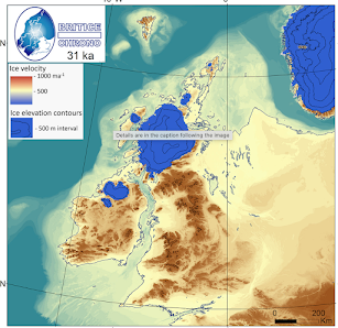

Glacier extent and activity during 31 ka and 24 ka time slices (after Clark et al, BRITICE final report 2022). Note the calving ice front and high velocity ice in St Georges Channel -- but the Devon and Cornwall coast was far to the west of its present position. In earlier glaciations the situation would have been very similar.

Debris-laden floating ice from calving ice fronts could have continued to move through St Georges Channel until c 17 ka, but prevailing SW winds would have ensured that the real "iceberg graveyard" was within the Irish Sea basin, to the north of St Georges Channel. (Source: Clark et al, 2022)
For decades people have been trotting out the familiar line that the big erratic boulders around the coasts of SW England are ice-rafted, dropped conveniently by icebergs and ice floes when glaciation was going on somewhere else. I used to think that way myself, in the days before enlightenment. But over the last decade or so I have argued consistently that ice rafting is not an option, since during the episodes of ice rafting in the Irish Sea, Cardigan Bay and Bristol Channel the coastlines of the time would have been far offshore. I have done many posts on isostatic and eustatic interactions, while harbouring some doubts about the actual RSL (relative sea-level) position because we just did not know enough about ice loading, crustal sensitivity and rebound rates.
Well, at long last there is a big paper from Bradley et al (2023) which brings together all the modelling work of the isostasy researchers with the modelling of the BRITICE project. It's a complex and sophisticated paper, but the results are all distilled in the two maps shown above, for 31 ka (during ice buildup) and 24 ka (during ice wastage). That 7,000 year span probably covers much of the time during which lumps of glacier ice might have been carrying big erratics through St Georges Channel emanating either from an advancing floating ice front or a retreating one. Deep water and calving are of course requirements, and as suggested on the map above, calving activity might have continued until c 17 ka. However, through this deglaciation / ice wastage episode, isostatic recovery and eustatic sea level rise appear to have been more or less in step, with the coastline stuck at or near the current -80m contour.
Anyway, the results of the new research are pretty conclusive. We can assume that the LGM modelling is applicable for the Anglian and Wolstonian glaciations as well. Even when the maximum possible amount of isostatic depression is fed into the model (for example, from the Welsh ice cap and small ice caps on Dartmoor and Exmoor) the shoreline was never close enough for the emplacement of big far-travelled erratics on or near the present shoreline from floating ice.
The boulders MUST have been emplaced by glacier ice at some time of extensive glaciation. It is of course quite possible that this glacial episode was so long ago (Anglian? Wolstonian?) that the coherent glacial deposits of the time have been largely degraded or removed.
=======================
Journal of Quaternary Science
First published: 17 April 2023
https://doi.org/10.1002/jqs.3523
Some of the big erratics assumed by some to have been ice-rafted:


I'm sure this has been asked before, but why didn't the Irish ice simply go south and over the edge of the continental shelf as it would have enough of a down slope gradient?
ReplyDeleteDave
Good question, Dave. Several components in the answer. The thing that matters in a working glacier is the surface gradient, not the bedrock or ground gradient -- there must be a continuous gradient, even though it might be very shallow as in the case of the Irish Sea Ice Stream (ISIS) where there was a highly deformable bed of sediments and high basal "lubrication". Next, all glaciers melt away in the ablation zone, beneath the equilibrium line. When the melting rate is very high, and where melting ice cannot be replaced by the forward moving ice supply, the glacier cannot exist any longer, then that is where the snout will be. Next, if the lowest segment of a big glacier or ice stream is afloat, as happened near the edge of the Irish Sea Ice Stream out near the shelf edge, calving becomes a major mechanism that limits the size of the glacier. You may get an ice shelf, but only where there is a large amount of annual accumulation of snow. Next, lateral spreading is always much more important than most of the glacial geomorphologists who have studied the ISIS have been prepared to admit. I have been on about this for years on this blog, and at last they are coming round to my point of view. That's why you cannot have had a narrow tongue of ice flowing from St Georges Channel through to the shelf edge -- there are no topographic constraints, and simply to behave in accordance with the laws of physics, the ice stream must have spread sideways up the Bristol Channel and (probably on at least two occasions) into the Somerset Lowlands.
ReplyDelete