THE BOOK
Some of the ideas discussed in this blog are published in my new book called "The Stonehenge Bluestones" -- available by post and through good bookshops everywhere. Bad bookshops might not have it....
To order, click
HERE

Monday 27 June 2022

The Preseli Roman Road -- a hypothesis in search of some evidence


This is a strange article -- thanks to Dave for sending it to me.  Some weeks ago we covered the advance press release, which as also very strange........

The Golden Road: Fact, Fable, Flemish, or ‘Flavian’?
Mark Merrony, Antiqvvs, Summer 2022, pp 25-34


Anyway, in this piece Mark Merrony discusses the documentary and "folk memory" aspects of the ancient trackwasy along the Preseli ridge, variously describes as the Golden Road, the Flemings Way, a Roman Road a a few more things besides.  It's a strange article, which could well have been cut in half -- since most of it consists of a somewhat self-indulgent description of springtime ramblings with a mountain bike across the landscape, with the author searching for depressions, sunken lanes, trackways, and anything that might indicate the presence of a Roman Road.  There are some nice photos and there are indeed many short sections of old rutted trackways, some of which I know well.  But nowhere does the author show that these are anything other than segments of ancient  routeways including bits of the old drovers' routes and also forestry tracks created at the times of forestry planting, maintenance and harvesting.  Heavy military vehicles used this area for training during WW2.  Some "sunken" sections have been deeepened by serving as streambeds during periods of heavy rain. No evidence is presented to show that the trackway was a single continuous route; no evidence is presented to show that it was paved or properly engineered; and no evidence is presented of a Roman connection.

Much speculation, made worse by gratuitous mentions of bluestones and bluestone haulage, again on the basis of no evidence whatsoever.  

Perhaps Mark will come back to us again when he actually has some evidence?


Glacial Erratics and Flights of Fancy


 Some of the erratics in Flimston Churchyard, all from NW Pembs and some incorporated here into headstones for graves.  Some were brought from sites c 3 km away.  Does anybody care EXACTLY where they came from?  No -- we are all very happy as it is.

I have been quite entertained by the attempt, by fellow blogger Tim Daw, to deny the significance of the "Newall Boulder" on the grounds that we do not know EXACTLY where it came from.  It was found by Hawley and his fellow diggers in their 1924 dig in a "secondary" position, having been worked and then thrown away by one of our mysterious ancestors.  Kellaway thought it was of great importance as a "proof of glaciation" at Stonehenge, but Tim is having none of it.   "If it has been moved by humans, and there are no records where from, then it adds nothing to the argument." says Tim, rather grandly.  " If you don't know where the glacier left it, it don't mean a thing."

Well, I have been studying glacial erratics for most of my life, and I think I can claim to know a thing or two about them.  Let me assure Tim that the Newall Boulder does add a great deal to the argument, and confirms what some of us have been saying for years about the likelihood of glacial action in the Stonehenge landscape.  For a start, it's not unique -- there are glacial erratics all over the place, particularly in the bluestone circle.  And in heavily populated countries like the UK glacial erratics are very seldom found in EXACTLY the places where they were dumped by ice.  If you find an erratic boulder in till it is probably still in the place where it was dumped by the ice, but most of the "free erratics" have been moved from fields into field boundaries or into stone clearance cairns, or gathered up for use in stone walls or built into dwellings and farm buildings.  Dare I say it, many thousands of them have been incorporated into Neolithic megalithic monuments, as pointed out by Stephen Briggs, Geoffrey Kellaway and then Olwen Williams-Thorpe and her co-workers many years ago.  The fact that these erratics have been collected and moved about does nothing to diminish their significance.  They help to present a coherent picture of where the ice came from, what the directions of movement were, and where the ice edge melted away.  A great part of the map of ice movements across the British Isles is based upon the evidence provided by erratics that are no longer EXACTLY where they were found.......

So the story of that lump of rock being shifted about the place in the Netherlands is a jolly little tale, of no significance whatsoever to the argument about Newall's Boulder.

I'll quote Kellaway again: "When found, the weathered boulder had been thrown away with chippings and other waste material. An attempt had been made to dress one end of the boulder but this, in Mr Newall’s opinion, had failed because of the sheared condition of the rock. It would appear that this small boulder, already deeply weathered, would never have been of any practical value. To suggest it had been carried from North Wales lo Wiltshire only to be tested and thrown away as worthless would imply an astounding lack of common sense and understanding of the properties of rocks on the part of the men who built Stonehenge. If, however, the bluestones were recovered locally from material scattered on the surface of the Chalk or were present in solution cavities, then the presence of inferior material is comprehensible. Having gathered up all the available bluestones, both from natural sources and from abandoned Neolithic structures, the Bronze Age builders of Stonehenge used the large ones for constructional purposes and tested the smaller boulders for the manufacture of implements. Those which were unsuitable were thrown away."

One further point.  It's a bit rich for people like Tim to argue that they must have absolute proof of the EXACT place where the Newall Boulder was emplaced, while accepting the fantasies about bluestone quarries at Rhosyfelin and Carn Goedog and a "lost stone circle" at Waun Mawn.  There is no hard proof from any of those sites of any Stonehenge-related Neolithic activity, just as there is no hard proof that any of the Stonehenge bluestones have been provenanced to "within a few square metres."  (The approximate provenancing -- to within a few sq km -- is good and should be applauded.  But EXACT provenancing?  Sorry, but that's just in the minds of the deluded.)

What's good for the goose should be good for the gander.


Thursday 23 June 2022

SH62 -- Much ado about nothing very much

Stone 62 at Stonehenge -- a nice little shaped pillar made of unspotted dolerite.  Courtesy the Stones of Stonehenge web site.

 I have been sent a link to a new paper on the provenancing of Stone 62, one of the unpotted dolerites at Stonehenge.

Details:

Portable XRF investigation of Stonehenge -- Stone 62 and potential source dolerite outcrops in the Mynydd Preseli, west Wales. by Nick J.G. Pearce, Richard E. Bevins, and Rob A. Ixer.  Journal of Archaeological Science: Reports 44 (2022) 103525.

It's a highly technical paper, involving a huge amount of time and expense in pursuit of a wild fantasy by Parker Pearson -- namely that one of the pits at Waun Mawn has the same cross-section as stone 62 at Stonehenge.  So the geologists have been roped in to help establish that as something accurate and reliable!  It's extraordinary, the lengths that people will go to in order to cofirm their biases.  I have seen the pit at Waun Mawn, and so have many others, and I have not found anybody who "sees the imprint" as Parker Pearson does.

So the intention is to SHOW that Stone 62 was, once upon a time, in that rather shallow and nondescript hollow in the ground.  First, there is a need to show where SH62 came from.  It's a nice little shaped pillar which looks as if it might have come from eastern Preseli, where there is columnar jointing in the unspotted and spotted dolerite -- but it has clearly been shaped and dressed rather carefully at Stonehenge.

The  paper cites earler attempts at provenancing and sampling,  and reports the results of recent pXRF work in Preseli and at Stonehenge.  That work is quite interesting, and I was very interested to read of the multiple sampling work done on rock surfaces on the east Preseli tors and the attempts to unravel the bias that might be introduced to the work when comparing results from weathered and unweathered surfaces. 

Anyway, the work points quite convincingly not to Cerrigmarchogion -- as previously speculated -- but to the small crag called Carn Ddu-bach, not far from Carn Ddafad-las at the eastern end of the ridge.  This is not far from the prominent peak of Foel Drygarn.  Interesting -- so we have yet another bluestone source and yet another setback for those who stick quite irrationally to the belief that the bluestones were sacred and special, and that they came from Neolithic quarries.  The new source crag is around 6 km from Waun Mawn.

The rational thing at this point would be for the geologists to say "Multiple dolerite sources = glacial entrainment and transport."   One might also wonder why our heroic ancestors might like to cart lumps of unspotted dolerite from Carn Ddu-bach all the way to Waun Mawn when there are perfectly fine outcrops of the same rock type within a couple of hundred metres......

But not a bit of it.  Nick Pearce and his colleagues are made of sterner stuff, and they are sticking to the Waun Mawn fantasy as if their lives depend on it, while pretending to keep a distance.  It's all more than a little obsessive, and rather sad.

Quote:

" Now that a source for Stone 62 has been established at approximately 6 km ESE of Waun Mawn (most probably at Garn Ddu Fach but possibly neighbouring Carn Ddafad-las), it is important to determine if any of the extant stones at Waun Mawn might have the same source. If confirmed, these outcomes may support the proposal of Parker Pearson et al. (2021), who suggested that Stonehenge Stone 62 once stood in stonehole 91 at Waun Mawn. Analysis of the extant stones at Waun Mawn is currently underway."

"IT IS IMPORTANT TO DETERMINE....." ???  Come off it, guys -- it is not in the least important, since the Waun Mawn fantasy has no archaeological or other value whatsoever, apart from the maintenance of MPP's rather ragged reputation.

This all brings to mind the Black Knight in "Monty Python and the Holy Grail" --  'Tis but a scratch!!".......


Wednesday 22 June 2022

Dacites and the fictional orthostat

 Ixer and Bevins keep on publishing at a furious rate in conjunction with assorted colleagues-- I am not sure what the beloved WANHM magazine would do without them! The latest article is entitled "Stonehenge Dacite Group D -- fact or fiction?". WANHM Vol 115, pp xx - xx. Strange title, since if the group is a fiction it is fiction of their own inventing. It's like putting up an Aunt Sally in order to have the satisfaction of knocking it down.......

Anyway, the article is available via Academia for those who want to check it out.

We are all (and that includes the authors of this latest piece) confused by the sheer abundance of fragments (the authors never differentiate between "fragments" and pebbles or stones) of widely differing lithologies scattered across the Stonehenge landscape.  Most geologists, in their shoes, would have long since abandoned the very idea of bluestone quarries, since both monoliths and fragments are so hugely variable in their characteristics that they must have come from multiple locations in West Wales and further afield. But they insist on seeking to gather their samples into groups in an attempt to minimise the number of "provenences" because that is the only way they can maintain the human transport hypothesis;  it makes no sense at all for Neolithic tribesment to have wandered all over West West collecting up stones from here, there and everywhere just to cart them off to Stonehenge and then throw them away or break them up.

Anyway, here we go again, with 8 rather inconvenient fragments analysed and found not to match up with anything in particular.  They do seem to match with one another.  The authors do not know where they came from, and assume (without any foundation) that they must have come from a missing orthostat, and that they have most probably come from North Pembrokeshire.   They also consider that the fragmants are "true bluestones", whatever that may mean.

For the sake of completeness, here is the latest classification:


Hmmm -- just as we were getting used to Volcanic Group B, it's disappeared into thin air, to be replaced by Dacite Group B.  Whatever next?

In their conclusion the authors do consider the possibility that the unassigned dacite fragments might have been introduced to the area as glacial erratics, but they dismiss that option on the grounds that no other "unequivocal" glacial erratic has ever been found in the Stonehenge landscape.  One might ask: "What about all those bluestone boulders that make up the bluestone circle?"  And one might also ask: "What about Newall's ignimbrite boulder?"  Of which more anon.

And who gets to decide what is equivocal and what is unequivocal?  Are the famous bluestone quarries "unequivocal"?   Is MPP's "lost circle" unequivocal"?  Ixer and his friends may think so, but there are very many of us who beg to differ.


Kellaway text on the Newall Boulder


Because the text on the scanned version of this 1991 report is not easy to read, I have done an OCR scan and here it is again.

RSN 18 ignimbritic tuff-lava

Description by RK Harrison: “This large, dark blue-grey, hard, flinty (? partly worked artifact) shows a white weathered crust up to 5 mm thick. The thin section shows a complex structure of very finely banded welded tuff (compressed foliated shards cemented by fine silica) with composite quartz grains and strings of dusty leucoxene, separated by patches of much finer grained, finely fluxioned glassy lava with patches of granular quartz, This specimen appears to represent a complex of originally viscous glassy lava and welded vitric tuff, all presumably of rhyolitic composition.”

The dimensions and general appearance of the rock are shown in Plates 35 & 36.

Comparison of this ignimbritic rock with other Welsh Ordovician volcanic rocks suggests that it is more closely related to the known ignimbrites of North Wales than to those of the Mynydd Preseli area of Dyfed. On the other hand none of the ignimbrites available for comparison provided a sufficiently good match to enable a link to be made with one specific locality. At the time. this conclusion appeared to be disaappointingly vague and out of line with some of the more dogmatic slatements made in respect of Stonehenge rocks. In the light of more recent work, however, Mr Harrison's cautious approach has been fully justified.

If the ignimbritic tuff-lava is indeed an erratic of North Wales origin and the ice which conveyed it is as old as it appears, then careful consideration must be given to the value of implying direct derivation from individual exposures or outcrops which exist at the present day. In the 247 Ma which may have elapsed since this Pliocene glaciation occurred, the mountainous parts of Wales (both north and south) have undergone substantial changes of relief. While, therefore, it may be justifiable to compare the Stonehenge rocks with suites of Welsh Palaeozoic igneous and metamorphic rocks on a regional basis, it may not be possible to give precise locations without having more information about the Pliocene relief and surface geology of Wales than is currently available. (Note: Kellaway was fascinated by the idea of a very large Pliocene Glaciation which occured when the landscape looked very different to that of today. Most of his ideas are well supported by modern research, but not this one!)

The weathered zone seen on the surface of the ignimbritic boulder is similar to other weathered exteriors of specimens examined by Mr R. Sanderson (Appendix Ill). This type of weathering is to be seen at the present day in peaty or humic environments and could have occurred before the rock was moved in ice from Wales to Salisbury Plain. Reporting on some of the ophitic dolerites from Stonehenge, Mr Harrison commented that "In order to ascertain the differences between the altered outer crust of pale dolerite and the fresher, blue-grey interior, X-ray diffraction photographs were taken of powders drilled from the respective zones in ENQ 2301, the outer crust here being about 5 mm thick. Mr B.R. Young reports that both samples contain chlorite, quartz, feldspar, pyroxene and amphibole. The crust contains more quartz and less feldspar than the interior. Kaolinite was not detected. Superficial leaching by acid water has broken down the feldspar, leaving residual silica."

If the weathering does date from before the translation of the rock to Wiltshire then the stone must have been conveyed either by hand or in ice. If the bleaching and weathering took place after arrival at Salisbury Piain then the boulder might have been carried by fluviatile or fuvioglacial transportation, though the weakness of the rock (due to shearing) argues strongly against fluviatile transport from Wales, or rounding in any medium other than ice.

When found, the weathered boulder had been thrown away with chippings and other waste material. An attempt had been made to dress one end of the boulder but this, in Mr Newall’s opinion, had failed because of the sheared condition of the rock. It would appear that this small boulder, already deeply weathered, would never have been of any practical value. To suggest it had been carried from North Wales lo Wiltshire only to be tested and thrown away as worthless would imply an astounding lack of common sense and understanding of the properties of rocks on the part of the men who built Stonehenge. If, however, the bluestones were recovered locally from material scattered on the surface of the Chalk or were present in solution cavities, then the presence of inferior material is comprehensible. Having gathered up all the available bluestones, both from natural sources and from abandoned Neolithic structures, the Bronze Age builders of Stonehenge used the large ones for constructional purposes and tested the smaller boulders for the manufacture of implements. Those which were unsuitable were thrown away.

It is worth noting that Sir A. C. Ramsay (1863) observed that the foreign stones of Stonehenge include rocks which are petrologically similar to those of North Pembrokeshire and that others resemble rocks from Caernarvonshire and the Lilandeilo Flag district of Montgomeryshire west of the Stiper Stones. This appears to be the first published suggestion that the bluestones may include rocks similar to these found both in southwest and North Wales.

----------------------------

From: 1991: "The older Plio-Pleistocene glaciations of the region around Bath." In Kellaway, GA (ed) Hot Springs of Bath, pp 243-41.

Tuesday 21 June 2022

Stockholm Archipelago glacial clasts


My art installation consisting of 11 clasts of diminishing size.  These were picked up at random from washed till on the foreshore of Blido.  They are all made of PreCambrian basement rock -- granite, gneiss, basalt, volcanic ash etc.  Only two or three of these rocks are bullet shaped.

You can pluck glacial erratic clasts out of till exposures and washed till all over the place in the islands of the Stockholm Archipelago -- they are generally clean and easy to find becuase the finer materials have been removed by "washing" as the land has risen from the sea during the process of isostatic recovery.  A. couple of things are noteworthy:

1.  The clasts do NOT carry traces of ancient weathered crusts or surfaces; all the facets and edges are equally unweathered, although some parts of the clasts have been stained or modified / abraded / fractured more recently than others.

2.  Rough blocks and slabs predominate, with multiple facets.  Maybe about ten percent of clasts have a bullet shape.

Some clasts have nine or ten facets -- some abraded and others clearly originating as fracture scars.  Some scars are old and some are young; some of the older ones are modified by later abrasion and by smaller and later fractures.  Almost all combinastions are possible.


Variations on a theme.  Three small clasts collected from a till exposure on Blido.  From the left: white granite, greenish volcanic ash and pink granite.  All have at least six facets.  All three have quite fresh fracturs scars on their lee (blunt) ends, and all have heavily abraded edges.  Interestingly, all three have lost their bullet tips (stoss ends) through fracturing.  A point is always vulnerable.


The greenish ash clast, showing a big fracture scar on the lee end and another smaller pressure fracture scar.  Subsequent abrasion has modified the sharpness of these features.


Striations on the same clast -- a deep one sub-parallel to the long axis but others running across it -- showing that at some stage the long axis has been at 90 degrees to the direction of ice flow and clast transport.

Monday 20 June 2022

The mysterious boulder 38


The strange mis-shapen boulder referred to as SH38, partly obscured by sarsen SH14. Courtesy the Stones of Stonehenge web site. Its place of origin is still a mystery.

In checking out what the score is with regard to dark blue flinty welded tuffs and so forth, I wondered whether this boulder might be related to the Newall boulder. There is a chance, but much more geology needs to be done by the experts. I checked back to a previous post about SH38 and the assorted volcanics at Stonehenge and in the surroundingt landscape:

https://brian-mountainman.blogspot.com/2015/04/new-paper-on-bluestone-38.html

Hard ‘Volcanics with sub-planar texture’ in the Stonehenge Landscape by Rob A. Ixer, Richard E. Bevins and Andy P. Giże
Wilts Arch & Nat Hist Mag 108 (2015), pp 1-14

On giving the paper a fresh read, I am impressed by how strongly biased it is towards the ruling human transport hypothesis, with -- over and again -- a "forcing" of analysis and interpretation into the following assumptions: (a) that the bulk of bluestone fragments in the debitage MUST have come from North Pembrokehire; and (b) that bluestone fragments can only exist at Stonehenge if they have been knocked off past or present monoliths transported by our heroic ancestors. So the paper is deeply unsatisfactory since it completely fails to address the possibilities that the bluestone monoliths might have been glacially transported, and that large numbers of fragments in the debitage might have nothing whatsoever to do with the known monoliths. Furthermore, many of the small boulders, pebbles and broken fragments might have nothing whatsoever to do with Pembrokeshire. They could be glacial erratics from closer to home, or maybe from further afield.

Putting all that to one side, it's tempting to suggest that there might be a link between the Newall boulder and SH38, and that the "welded vitric acid tuff" might be related to other rock samples looked at by Ixer and his colleagues and identified as Volcanic Group B.  Ixer and his colleagues referred to "small, often sub-rounded, rather than angular flaked, fragments throughout Stonehenge and its environs."

That comment has always caused me -- and others -- to wonder whether the geologists have been looking at glacially-transported or glaciofluvially-transported stones in the Stonehenge sediments without recognising what they have been looking at..........  Again, this suggests a possible link with the Newall boulder, which is faceted and almost certainly glacially transported.

Quote:
"...........
Volcanic Group B, hard rocks that are partially characterised by an unusual mineralogy including two forms of graphitising carbon. Only twelve Volcanic Group B samples have been recognised from the Stonehenge debitage."

Quote:

"Conclusions 
 
Orthostat SH38 and twelve pieces of debitage that constitute the new Volcanic Group B class of debitage are sufficiently uniform in terms of their mineralogy, grain size and textures that it seems probable that they are all from the same rock rather than just from the same outcrop.

Although this debitage is numerically rare it has a wide spatial distribution in the Stonehenge Landscape notably within the Darvill and Wainwright April 2008 excavation and Heelstone Ditch but also including within Trench 45 in The Avenue and Aubrey Hole 7 in Stonehenge. Although a lithic with graphitising carbon was found from close to the Stonehenge Greater Cursus no SH38 debitage has been recognised from there with any certainty. The SH38 debitage distribution is similar to that found for orthostat SH48 but is more extensive than that for the Altar Stone.

The temporal distribution of the SH38 debitage is very similar to that for SH48 in that most pieces are found from post Neolithic contexts but are less ‘bunched’ than that from the Altar Stone.

The newly reported SH38 debitage has extended the range of petrographical features beyond those seen in orthostat SH38, notably to include the presence of large zircons, rare earth-bearing minerals, tube pumice and a significant fine-grained siliceous component. This in turn suggests that were the single geochemical analysis for SH38 (Thorpe et al. 1991) and taken from a very small sample , to be augmented by new analyses from the present samples, a geochemistry that was closer to the bulk geochemistry for SH38 could be achieved. An enhanced petrography plus a more representative geochemistry would help to narrow the possible geographical sources for the orthostat. On present knowledge this is still expected to be found within the Ordovician Volcanic sequences, in the north Pembrokeshire area but the net is tightening."

Petrologist RK Harrison on the petrology of the Newall Boulder: “This large, dark blue-grey, hard, flinty (? partly worked artifact) shows a white weathered crust up to 5 mm thick. The thin section shows a complex structure of very finely banded welded tuff (compressed foliated shards cemented by fine silica) with composite quartz grains and strings of dusty leucoxene, separated by patches of much finer grained, finely fluxioned glassy lava with patches of granular quartz. This specimen appears to represent a complex of originally viscous glassy lava and welded vitric tuff, all presumably of rhyolitic composition.”.   

I wonder whether that is a description of one of the rock types now referred to by Rob Ixer and his colleagues as "Volcanic Group B" or "Dacite Group B" ??

Match all this with the 1971-72 descriptions of the welded acid vitric tuffs examined in 1971-72 by Kellaway, Harrison, Smith, Howells and Nutt, and we have an intriguing possibility that there is rather more glacially transported material lying around in the Stonehenge landscape than the geologists would have us believe.

Sunday 19 June 2022

Sample OU2 was not from Newall’s Boulder


In my post on the Newall boulder on 6 June, I stated that prior to the publication of their big 1991 report on the provenances of the Stonehenge bluestones, the OU team involving Olwen Williams-Thorpe and many others examined a sample supposedly from Newall’s boulder and found it to be a blue-grey rhyolite similar to many other samples collected in Stonehenge digs through the years. I thought therefore that the provenance of the boulder was pretty well established……..

But I was wrong.

I have done some more detective work. In 1989 the OU team (which included Rob Ixer) examined as many bluestone fragments as they could find, including one that they referred to as RSN18 - ENQ2305. They admitted that they did not know where it had come from, and there was no mention in their text of Newall’s boulder. They renamed it OU2 and the analysis showed it to be a typical blue-grey rhyolite from the north slopes of Mynydd Preseli. However, they listed the sampled rock fragment as having dimensions 10 cm x 7 cm x 3.4 cm and a weight of 244 gm. The Newall boulder with which we are concerned does not have those dimensions and it is certainly not a blue-grey rhyolite. It is, according to Harrison, a dark blue / blackish flinty welded tuff. The boulder dimensions are c 22 cm x 15 cm x 10m cm, and I guess its weight as being around 10 kg. The OU team did not examine the smaller cut IGS boulder sample either, since that has dimensions c 8 cm x 4 cm x 6 cm — ie considerably smaller than OU2. We know that the IGS staff examined at least five samples / thin sections from the Newall collection, since there is a reference in correspondence to a sample numbered ENQ2301. We also know that the record keeping was somewhat chaotic, and in one letter to Kellaway, Newall referred to his notes and labels being eaten by mice while the samples were stored in his attic……..

There is another label marked "36/1978" on the flank of the boulder, showing where a further sample was taken, two years after the boulder came into the possession of the Museum.  The cut marks are quite clear.  We have not seen any record of that sample being analysed.

I think that the sample examined by the OU team came from one of the other smaller samples (of a quite different rock type) that has now found its way into the Salisbury Museum collection.

So we can reject that 1991 reference as unreliable, and concentrate on the examinations of the boulder by RK Harrison, Geoffrey Kellaway, R Sanderson and BR Young. They all handled the boulder, took samples from it, knew its provenance in the Hawley Stonehenge dig, and discussed among themselves and with Newall where it might have come from. I have on the file some very interesting correspondence. So the Stonehenge provenance is, as they say, rock solid…….. and far more reliable than the provenances of many of the other fragments collected from Stonehenge digs. That is all that matters.

PS.  I have noticed that the text painted onto the rock says RSN18.  But the bit that says ENQ2301 is on a sticky label.  Shall we guess that when Newall handed over his samples to Salisbury Museum in 1976, with many of the labels missing because the mouse in the attic had eaten them, new labels had to be written out and appended to assorted lumps of rock?  And shall we guess that somebody inadvertently put the wrong label onto the Newall Boulder?  


Friday 10 June 2022

Sub-glacial clast modification


This is a very interesting article -- mostly about the processes that affect the formation of subglacial till, but incorporating some valuable information about how clasts are affected on the glacier bed.  There are many different positions for clasts on the bed, or indeed within the bed, in fluid or mobile till.  In the bed there may be clasts that are rolling, tumbling, sliding or sticking.  During its lifetime voyage, a clast (large or small) may shift from one subgacial environment to another, many times -- and even over a succession of different glaciations.  Because in some situations clasts take the line of least resistance, with a long axis aligned with the direction of ice flow, a bullet shape or wedge shape may be created and maintained, but if a clast is then "tumbled" the pointed or thin end may be more susceptible to fracturing -- so the shape will revert to that of a block with each axis more or less equal in length.  But there can be facets galore, and abrasion or gouging features may be present on any or all of the facets or faces.  Is a bullet shape a real diagnostic feature?  It can be........

Subglacial till: Formation, sedimentary characteristics and classification
September 2006
Earth-Science Reviews 78(1)


Bullet-shaped clasts, indicative of formation beneath warm-based ice (Storey et al, 2010)


Cosmogenic nuclide exposure age constraints on the glacial history of the Lake Wellman area, Darwin Mountains, Antarctica
December 2010
Antarctic Science 22(6)

DOI:
10.1017/S0954102010000799

B.C. Storey
David Fink
D. Hood
Mark Stevens et al

See also:

Krüger, J. (1984). Clasts with Stoss-Lee Form in Lodgement Tills: A Discussion. Journal of Glaciology,30(105), 241-243. doi:10.3189/S0022143000006006

This paper discusses the "double stoss-lee form".  I can understand how the stoss-lee form is created by streaming and abrasion on the up-glacier end of a bullet-shaped clast, and pressure-induced fracturing at the lee end.  But I am not all that convinced by the "double" part of the theory.......... according to theory, fracturing and gouging is most likely to occur where the subject (boulder or bedrock mass)) is under tension and the object (tool) is under compression. Where the tool and the boulder are both under compression,  abrasion is most likely to occur.  I do not understand the theory that creates a low pressure zone on the up-glacier side of the boulder (situation d in the above diagram); and I am more inclined to think that if there is fracture damage on both ends of a bullet-shaped boulder it is most likely to have occurred because the boulder has been "flipped" or turned over.


Bullet-shaped clast with a stoss-lee form in front of Myrdalsjokull, Iceland.   Ice moved from left to right.  Note that there are several fractured faces at the lee end, suggesting some "rolling" of the clast during subglacial transport.


Some of the features of bullet-shaped clasts thought to have been fashioned in a subglacial environment.  There are multiple variations on these themes, with intersecting fractures, rough scars which turn into polished facets, gouges in more or less random positions, and crossing striations.  There will also be modifications related to the lithology and internal structure of the clast, related to foliations, ancient fractures, presence of quartz veins etc......  Many clasts made of sedimentary rock types will incline towards a more slab-like shape. (This diagram is based on field photos in my collection)

It should be emphasised that the majority of clasts in glacial deposits (moraine and till) are NOT shaped like this.  To become "bullet shaped" a clast has to remain in a more or less constant alignment (the position of least resistance) for a long time.  This allows the same set of processes to operate as we see with roches moutonnees. (See multiple posts on this blog -- use the search facility.)  Most clasts are rolled and tumbled, with fractures occurring on all sides, which makes them eventually "block shaped" -- square or rectangular boulders (with their corners and edges knocked off) rather than elongated pillars.  

Nonetheless, when you DO find a clast that has these "bullet" characteristics, it's a very good diagnostic feature pointing to subglacial transport.

Glacial impacts on smoothed surfaces


Beautiful things happen when glacier ice which is thick and powerful passes over relatively smooth surfaces.  First, it polishes them with various grades of sandpaper.  Then it takes tools of various sizes and uses them to fracture and damage the surface in various ways -- striations, parallel grooves and gouges, channels, crescentic gouges, chatter marks and many more features that are difficult to classify.  Every rock surface has a unique history of smoothing, grinding and fracturing.  The features are all things of beauty.  I do not really need to show these images, but some people are very slow learners!

And by the way, the last two images are from the rock surfaces at Rhosyfelin........


Glacial clast morphology


Long ago I lectured in Durham University about this sort of thing, and was somewhat immersed in the topic during my research in the Arctic and Antarctic.    Basic question:  is it possible to look as a clast (a stone or a boulder) and identify it as having been transported by glacier ice?  There is a vast literature, and hundreds of geomorphologists have attempted to find criteria that can be numerically or statistically quantified.  There has been considerable success in this enterprise -- but it is nonetheless true that every clast has a unique history and is therefore unique in its shape and surface characteristics.  So just as skilled doctors will make diagnoses on the basis of "instinct" or "experience", glacial geomorphologists will assess clast origins on the basis of "look" and "feel".  Sound and taste do not often come into it.........

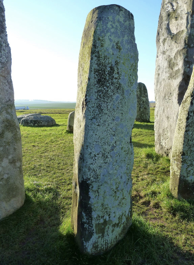
When I say that the bulk of the bluestones at Stonehenge (including Newall's boulder) "look like glacial erratics" what do I actually mean?  Well, this is a good start: 

https://link.springer.com/referenceworkentry/10.1007/978-1-4614-3134-3_182

Description
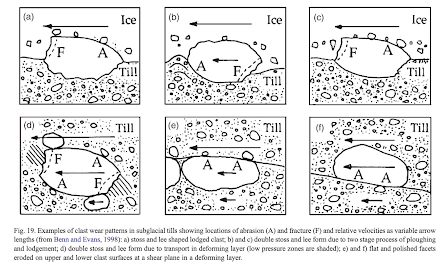
Glacial clasts are typically subangular to subrounded, exhibit asymmetrical wear patterns, and often have characteristic polished and faceted faces with abundant striae oriented parallel to the long axis of the clast (Benn and Evans 2010).

Morphometry
Clasts can range from pebble (4–8 mm) to boulder (>256 mm) size and can be of varying lithologies. They can exhibit a variety of shapes but are characteristically subangular to subrounded, and clasts exhibiting bullet, pentagonal, and/or stoss and lee forms are considered especially diagnostic (Boulton 1978; Sharp 1982; Krüger 1984; Eyles 1993; Benn and Evans 2010). Clast shape and roundness can be visualized using RA-C40 plots developed by Benn and Ballantyne (1994), systematized using TRI-PLOT by Graham and Midgley (2000) and used by Atkins.

References

If you go to the SpringerLink web page you will find hyperlinks to many of these articles.

Adam WG, Knight PG (2003) Identification of basal layer debris in ice-marginal moraines, Russell Glacier, West Greenland. Quat Sci Rev 22:1407–1414

Agassiz L (1840) Études sur les glaciers, Neuchâtel. Available via Archive.org. http://archive.org/details/etudessurlesgla00agasgoog. Accessed 07 Oct 2012

Atkins C (2003) Characteristics of Striae and Clast shape in glacial and non-glacial environments. Dissertation, Victoria University of WellingtonGoogle Scholar

Atkins CB (2004) Photographic atlas of striae in glacial and non-glacial environments (Antarctic Data Series Report 28). Victoria University of Wellington, New Zealand. http://www.victoria.ac.nz/antarctic/pdf/ADS28.pdf. Accessed 07 Oct 2012

Benn DI, Ballantyne CK (1994) Reconstructing the transport history of glacigenic sediments: a new approach based on the co-variance of clast shape indices. Sediment Geol 91:215–227

Benn DI, Evans DJA (1996) The interpretation and classification of subglacially deformed materials. Quat Sci Rev 15:23–52

Benn DI, Evans DJA (2010) Glaciers and glaciation, 2nd edn. Arnold, London

Bennett MR, Hambrey MJ, Huddart D (1997) Modification of clast shape in high-Arctic glacial environments. J Sediment Res 67:550–559

Boulton GS (1978) Boulder shapes and grain-size distributions of debris as indicators transport paths through a glacier and till genesis. Sedimentology 25:773–799

Crowell JC, Frakes LA (1972) Late paleozoic glaciation: part V, Karroo Basin, South Africa. GSA Bull 83:2887–2919

Dreimanis A (1989) Tills: their genetic terminology and classification. In: Goldthwait RP, Matsch CL (eds) Genetic classification of glacigenic deposits. Balkema, Rotterdam, pp 85–88

Eyles N (1993) Earth’s glacial record and its tectonic setting. Earth Sci Rev 35:1–248

Graham DJ, Midgley NG (2000) Graphical representation of particle shape using triangular diagram: an excel spreadsheet method. Earth Surf Process Landf 25:1473–1477.

Hambrey MJ (1982) Late Precambrian diamictites of northeastern Svalbard. Geol Mag 119:527–551

Harland WB (1964) Evidence of Late Precambrian glaciation and its significance. In: Nairn AEM (ed) Problems in palaeoclimatology. Interscience/Wiley, London, pp 119–149

Hart JK (1995) Subglacial erosion, deposition and deformation associated with deformable beds. Prog Phys Geogr 19:173–191

Hart JK (2006) An investigation of subglacial processes at the microscale from Briksdalsbreen, Norway. Sedimentology 53:125–146

Head JW, Mustard JF, Kreslavsky MA, Milliken RE, Marchant DR (2003) Recent ice ages on Mars. Nature 426:797–802

Head JW, Marchant DR, Dickson JL, Kress AM, Baker DM (2010) Northern mid-latitude glaciation in the Late Amazonian period of Mars: criteria for the recognition of debris-covered glacier and valley glacier landsystem deposits. Earth Planet Sci Lett 294:306–320

Hoffman PF, Kaufman AJ, Halverson GP (1998) Comings and goings of global glaciations on a neoproterozoic tropical platform in Namibia. GSA Today 8:1–9

Holmes CD (1960) Evolution of till-stone shapes, central New York. Geol Soc Am Bull 71:1645–1660

Humlum O (1985) Changes in texture and fabric of particles in glacial traction with distance from source, Mýrdalsjökull, Iceland. J Glaciol 31:150–156

Krüger J (1984) Clasts with stoss-lee forms in lodgement tills: a discussion. J Glaciol 30:241–243

Lucchitta BK (1981) Mars and Earth: comparison of cold climate features. Icarus 45:264–303

Neukum G, Jaumann R, Hoffmann H, Hauber E, Head JW, Basilevsky AT, Ivanov BA, Werner SC, van Gasselt S, Murray JB, McCord T (2004) Recent and episodic volcanic and glacial activity on Mars revealed by the high resolution stereo camera. Nature 432:971–979

Nobles LH, Weertman J (1971) Influence of irregularities of the bed of an ice sheet on deposition rate of till. In: Goldthwait RP (ed) Till: a symposium. Ohio State University Press, Columbus, pp 117–126

Oberbeck VR, Marshall JR, Aggarwal H (1993) Impacts, tillites, and the breakup of Gondwanaland. NASA Publications. Paper 74. Available via Digital Commons. 

Rampino ML (1994) Tillites, diamictites, and ballistic ejects of large impacts. J Geol 102:439–456

Sharp MJ (1982) Modification of clasts in lodgement tills by glacial erosion. J Glaciol 28:475–481

Van Hoesen JG, Orndorff RL (2004) A comparative SEM study assessing the micromorphology of glaciated clasts of varying lithologies. Can J Earth Sci 41:1123–1139

Wentworth CK (1936) An analysis of the shapes of glacial cobbles. J Sediment Petrol 6:85–96

How to cite
Cite this entry as:Van Hoesen J.G. (2015) Glacial Clast. In: Hargitai H., Kereszturi Á. (eds) Encyclopedia of Planetary Landforms. Springer, New York, NY. 

Thursday 9 June 2022

Dale, Judd and Engleheart versus Thomas


I found this digitised version of the first ever issue of the Antiquaries Journal. Interesting stuff!  I think this interim report relates to the 1919 and 1920 Hawley work at Stonehenge— presumably this presentation / discussion  was in 1920, well before HHT’s famous paper was published in 1923 in the same journal.  The stone examined by Dale might have been "exhibited" by Hawley, or by Thomas.  Probably the former.

This record -- from January 1921 -- is the first record of HHT's views on the bluestones and how they were transported from Pembrokeshire to Stonehenge. (I have seen this reported as a "lecture" by Thomas, but I now think there was no lecture, and this this  is the earliest printed record of his views as presented in public. )  Notice how forceful and well prepared Thomas was, even before he had completed his research on the bluestones as presented verbally to the Society on 19 April 1923.  He was quite sure, even in 1920, that the bulk of the bluestones had come from the "Prescelly Mountains."  Not mincing his words, he claimed that the idea of glacial action "was contrary to all sound geological reasoning".   And he was also quite sure -- in his own mind at least -- of "human selection and conveyance from a distance."

In their contributions to the discussion Dale and Engleheart were much more succinct -- but both agreed that the bluestones were -- as proposed by Professor Judd -- glacial erratics.


Professor John Wesley Judd, who argued for the glacial transport of the bluestones in 1901.


=====================

Antiquaries Journal
Being the Journal of the Society or Antiquaries of London
Vol. I January, 1921 No. 1, pp 19-41


The Excavations at Stonehenge, by Lt.»CoL Hawley, F.S.A., 
with an appendix by C. R. Peers, Secretary

Stonehenge : Interim Report on the exploration

By Lt.-Col. W. Hawley, F.S.A.

(Main text excluded here.)

Concluding remarks:
I should like to say something about the foreign stones.
Possibly they once stood in the Aubrey holes, for if the number
of the holes proves to be what we expect there would have been
just about sufficient of them to make the inner circle and horse-
shoe. The Aubrey circle was presumably earlier than Stonehenge,
perhaps of the Avebury period, and would have been of undressed
stones which were dressed on removal to their present position.

This of course does not bring us any nearer their place of
origin, but Mr. Tapp has very kindly undertaken to enlist the
services of the Geological Survey on this point.

In conclusion I should like to express my thanks to my friend
and colleague Mr. R. S. Newall for the great help he has given
throughout the work. He has made all the drawings, and the
excavation of the Aubrey holes was all his labour. Also I should
like to record my thanks to all the members of the Office of
Works staff for their constant and courteous assistance.

Discussion

Dr. H. H. Thomas, Petrographer to H.M. Geological Survey, said that he was well acquainted with small specimens and sections of the Stonehenge foreign stones, and, through the kindness of Colonel Hawley and Mr. Tapp, he had now had ample opportunity of studying the stones themselves. He had not altogether been unprepared to find that, with a few exceptions, all the 'bluestones ' were linked together by a common character, that made it practically certain that they had all been derived from the same area, and possibly from the same rock- mass. The bluestones are mainly diabases that are remarkable for the presence of white or pinkish irregularly bounded felspathic spots that vary from the diameter of a pea to twice or three times that dimension. The speaker pointed out that the occurrence of such felspathic spots was highly characteristic of, and as far as he was aware confined to, the diabase sills of the Prescelly Mountains of Pembrokeshire. Many such general localities as Devon, Cornwall, Wales, and Cumberland had been suggested by previous writers as producing similar rocks, but now he was glad to be able for the first time to point to a locality where there existed a rock absolutely identical with that of which the majority of the bluestones was composed ; and it occurred both in situ and as boulders comparable in size to the Stonehenge monoliths. Another highly characteristic rock of which there were two stones at Stonehenge, and of which an abundance of chips had been unearthed in recent excavations, was a beautifully banded spherulitic rhyolite. There should be no difficulty in identifying its source, and the speaker hoped shortly to be able to do so. 

With regard to the majority of the bluestones, he felt certain that their ultimate source lay in the Prescelly Mountains and in the boulder- strewn area to the immediate south-east. All possible proximate sources, however, must of course be investigated, but he felt that the idea of Pembrokeshire boulders being carefully selected from practically all other rocks, and stranded on the high ground of Salisbury Plain by glacial action, was contrary to all sound geological reasoning ; and that such an assemblage of stones, of which so many were of the same type, pointed to human selection and conveyance from a distance. He wished to point out that foreign boulders of large dimensions were not of infrequent occurrence in the low coastal region between Selsey Bill and the Isle of Purbeck, but, as far as they had been exiamined by the speaker, they had all proved to belong to types unrepresented among the stones of Stonehenge. He intended, however, further to investigate these boulders left presumably by floating ice, with the object of determining whether any were like those erected at Stonehenge. 

If it should be proved ultimately that Stonehenge types were represented," then the south coastal region would constitute a possible proximate source, but failing that there seemed to him no alternative but to go to the ultimate Pembrokeshire source for the material in question. His investigations were as yet only in their initial stages, and he expressed the hope that he might be able to throw still more light on the sources of the foreign stones that had always been the subject of so much speculation.


Mr. Dale quoted Professor Judd's opinion of 1901 that the blue- stones were glacial boulders left on Salisbury Plain ; and on one of the fragments exhibited he detected striae. Much had been collected for building purposes, and human transport from Wales would be a difficult matter.


Rev. G. H. Engleheart said the expert opinions left the meeting in a dilemma. The bluestones were declared not to be glacial, and even if they had been brought from Wales, it was difficult to believe that they were dressed only on arrival at Stonehenge. Transport of such an unnecessary weight argued lack of intelligence. In any case they were boulders and not quarried stones: one piece was striated, and he thought they were all of glacial origin.

Wednesday 8 June 2022

Are there more Newall striated erratics?


Section C13 -- photo of the Atkinson dig in 1964.  This is where Hawley was excavating in 1924.  At bottom right corner, bluestone 34.  Next to it, stump 33f, and to its left, at an angle, stump 33e.

Because there is a specific mention of four small erratics coming to light in the 1924 Stonehenge dig, we tend to assume that the "Newall erratic" is one of those -- but I am not sure.  In his report on the 1924 digging season, Hawley says:  "From time to time pieces of foreign stone have been found with signs of working upon them, and this season four have come to light that merit description."  They were all found in the "upper layer", c 25" below the surface.  Kellaway (having spoken to Newall) also refers to "a few" erratic stones carrying striations, all of which had been examined by Engleheart and Dale, and all considered to have been glacially transported.  Tim Daw reproduces a photo from Hawley's report, suggesting that a stone at the extreme left (circled red) was the one described by Kellaway and examined by Harrison and others in the IGS. I don't think that's correct -- it looks much too elongated. That might be one of the others -- now assumed lost.  


We know that Hawley and Newall were only interested in pieces of bluestone -- and presumably bluestone boulders and packing stones -- if there were signs of working on them.  All the others were thrown away.  Julie Gardiner (in the big 1995 Stonehenge volume by Cleal et al) reports that only 10% of finds were kept by Hawley-- so 90% were thrown away.  That is a tragedy -- and who knows how different the "establishment story" of Stonehenge might have been if priorities had been different.  So only 3,675 pieces of bluestone survive in the collections at Salisbury Museum and elsewhere, we can assume that 33,000 other bluestone pieces are in the waste trenches that were used as a repository for everything "uninteresting".

The site excavated by Hawley in 1924 is now classified as site C13, cut into a segment of the bluestone circle and adjacent to sarsen No 8.  It was also excavated by Atkinson in 1964 -- but by then most of the bluestone bits had been removed and thrown away! But in any case, from the photo at the head of this post we can see that there is a lot going on here -- with bluestone fragments and boulders all over the place. 


Stumps 33e and 33f (quite close to bluestone 34) are classified as altered volcanic ashes, belonging to Volcanic Group A in the Ixer / Bevins classification, although there has been some speculation that the stones might actually belong to Rhyolite Group A-C.  The problem is that these stumps have not been sampled, in spite of featuring strongly in two well-recorded digs. They are both crude flaky slabs, not pillars, and are "rubbish stones" that would not have been used if anything better had been available. Stump 33e in particular is an anomaly,  aligned in a direction that appears to make no sense -- almost perpendicular to the circumference of the bluestone circle.  Hawley was puzzled by it, and on p 239 of the 1995 Cleal et al volume on Stonehenge the authors appear similarly confused!!  

It's not known where the Newall boulder came from with respect to these stumps, but it cannot have been far away.  Is the boulder of the same -- or similar -- rock type as the stumps?  We shall see, in due course......... but on the basis of visual appearance alone, I would hazard a guess that the Newall boulder has nothing to do with the stumps.  The stumps are fragile and heavily fissured and foliated -- and the boulder is a single massive block with no signs of fracturing along lines of weakness. I'd guess that its provenance is quite different.

In conclusion,  we can be certain that there were other striated bluestones that were turned up and turfed out.  The question is this -- did Newall save any of these?  And if he did, where are they?


The site of Hawley's dig (C13) in 1924 (Fig 120, p 219 of Cleal et al, 1995.  Stones 33a, 33b, 33c and 33d are missing; stones 33e and 33f are present as broken and damaged stumps.  

===================

It should be noted that to the north of stone 33 (dolerite) there are three stumps (32 c, d and e ) that have been claimed (on visual grounds) to be linked to Rhosyfelin. Stump 32e cannot be linked to Rhosyfelin, because it is made of dolerite, but there is some focus on stones 32c and d -- with MPP claiming that his imaginary "extraction point" in his imaginary quarry could have provided the stranding stone now known as stone 42. That's a problem, since stone 42 is made of dolerite.  Perhaps he meant stone 44?  But that's dolerite too.  Or maybe 32d?  It''s all a bit of a muddle.  Parker Pearson claims that the stone extracted from his "extraction recess" had dimensions 40 cm x 45 cm -- but that is pure fantasy.   There is no way a stone with that sort of cross section could have come from the very small "gap" at Rhosyfelin that has featured so heavily in the media.....

Nonetheless, stump 32d is the one claimed by Ixer and Bevins as being a possible Rhosyfelin monolith............ hmmm, we shall see, since that one too is classified by Cleal et al (1995) as being made of spotted dolerite.  Yet another case of too much fantasy and too little science.


Salisbury Plain glaciation -- a VERY long time ago.........


After much thought, the blue line on this map shows where the outer limit of glaciation in Southern England might actually be located. Maybe this is a "composite line" showing the limits of different ice lobes of different ages, but this may also be the "Stage 16 glaciation" otherwise referred to as the Happisburgh or Cromerian glaciation, dated to c 650,000 years ago. The white line represents the outer limit of the Anglian glaciation, dated to MIS-12, around 450,000 years ago. 

Numbers identify key research areas: 1 Exmoor and the SW uplands (local ice caps and snowfields). 2 Somerset Levels. 3 Mendip. 4 Salisbury Plain. 5 North Wessex Downs. 6 Cotswold Hills. 7 Plateau drift remnants near Oxford. 8 Chilterns. 9 Chalky Till spread.


I'm increasingly convinced that the glaciation which I am suggesting for Salisbury Plain was considerably more extensive than the Anglian (c 450,000 years ago) and much older too.  I wouldn't agree with Geoffrey Kellaway that it was in the Pliocene, but the glaciation that comes into the frame was the Happisburgh (or Cromerian) glaciation currently dated at around 650,000 years ago.

This is my post in which I lay out the arguments:

https://brian-mountainman.blogspot.com/2022/02/southern-england-where-is-glacial-limit.html 

This, I think, is one of the most important posts I have ever done, and it explains why the evidence of glaciation is very patchy and subtle -- and difficult to interpret.  After all, we are used to dealing with glacial traces in the landscape that are only 20,000 years old.  the amount of denudation / sediment destruction / sediment dispersal that happens over more than half a million years is difficult to comprehend.  And we should not be too surprised if all we can find today are some heavily weathered erratic boulders in the landscape (or in megalithic monuments like Stonehenge) and some smaller glacial erratics embedded in sediments.........

Tuesday 7 June 2022

The malignant magic of Stonehenge: how a Roman Road story was transformed into a bluestone transport story


This is completely bonkers.  Today in the media there is nice simple story about Dr Mark Merrony (once of Lampeter Univ and now of Wolfson College, Oxford) finding what he thinks is a Roman Road -- or bits of it -- up on Mynydd Preseli, slightly offset from the route of the modern footpath that we often refer to as the "Golden Road". 

Rather, the story was nice and simple until the media hacks got to work on it and turned it into a story about the bluestone export trackway!  The headline above is typical -- and it is a lie, because nobody has claimed to have discovered bluestone haulage tracks at all. 

https://www.ancient-origins.net/news-history-archaeology/roman-road-wales-0016865 

What Dr Merrony has done is to speculate that a prehistoric route was being used during the Roman period, and that it could well be “the same route ancient people transported the bluestones down to Stonehenge.”  No facts, just a speculation tossed out in the knowledge that it would be seized upon by the more gullible and excitable sections of the media.

The nonsense story was also developed by the Express and the Mail -- both of which used the opportunity to recycle lots of old stories in support of the new one:


But at least both of those did have the good grace -- with ragerd to the bluestone haulage component -- to use the words "may" and "perhaps".

The only media outlet to play the story straight and responsibly was the Guardian:


It's a nice story anyway, without that ludicrous embellishment -- and Dr Merrony should be more careful with his press releases and statements to the press in future.  

Sadly, all this does is confirm that archaeology is now so obsessed with fantastical stories that it deserves no respect from anybody.

------------------

PS.  This is the BBC coverage of this crazy story -- it plays its part in the promotion of nonsense, as well as confirming that there is no long-term study here, involving the accumulation of hard evidence.  As far as we can make out, Dr Merrony was out for as walk in April, spotted some entrenched bits of trackway and started to put together some speculations.  Hmmm....


And he likes his mythological speculations -- in his last article the made a link between a Roman road section and King Arthur..........


Whatever next?  Paddington Bear and Dan Dare?


The Westonzoyland giant boulder


Purely by chance, I came across a digitised version of "The Archaeology of Somerset" by DP Dobson, published in 1931 and digitised by Dehli University!

https://archive.org/details/in.ernet.dli.2015.505319/page/n77/mode/2up

On p 78 there is a reference to the famous giant boulder at Westonzoyland, called "the Devil's Upping Stock" until it was cut up and disposed of

An upping-stock is a mounting block -- so if it was deemed suitable for the Devil, it must have been of great size -- maybe more than 2 x 2 x 2m -- and with a flat top.  

More information is contained in William Stradling's "Description of the Priory of Chilton Polden", pp 75-79 -- but I have been unable to track that one down..........

As for the possible location, there are a lot of moors around Westonzoyland, just to the east of the M5 motorway and near the village of North Petherton (where, as it happens, my sister once owned a hotel).........  We are in the territory of thick peat deposits, Sedgemoor and the Burtle Beds, about which there has been much discussion.

Could the giant boulder have been a glacial erratic?  Well, it was clearly in an unusual, prominent and "erratic" position unrelated to any rock outcrops.  Across most of the landscape peat beds and the sands and gravels of the Burtle Beds are at the surface, and the underlying Mercia mudstones (of Triassic age) are only exposed in a narrow strip running NW-SE, on the southern edge of Westonzoyland Village.  This is a ridge of slightly higher land.  The Devil's Upping Stock, in order to have survived as a "nuisance" until it was cut up, was clearly neither made of mudstone or sands and gravels.  Mudstone breaks down into rubble and slabs, and if the stone was suitable for "chimney pieces" (mantelpieces) it must have been either an igneous rock or a coherent limestone or sandstone.  Since mantelpieces were often exotic or showy, with status attached, we can speculate that the rock type itself was rather interesting........  why, otherwise, would Mr Hitchings have wanted to purchase it?

A giant glacial erratic?  Almost certainly, and Kellaway thought so too.   Carried by ice coming into the Somerset Levels depression from the west?  Almost certainly.  Linked in age to the glacial deposits at Greylake?  Almost certainly......