THE BOOK
Some of the ideas discussed in this blog are published in my new book called "The Stonehenge Bluestones" -- available by post and through good bookshops everywhere. Bad bookshops might not have it....
To order, click
HERE

Thursday 31 March 2022

Spotted dolerite erratics in SE Pembrokeshire


Two of the spotted dolerite boulders at the Llan site, Lampeter Velfrey.  One is more enlarged than the other, but the one above has larger and more "fuzzy" spots, and the lower ones has spots with sharper outlines.  This may suggest different origins.  Photos: Olwyn Pritchard and Dewi Bowen, Morien Project.

The Llan ruined Neolithic burial chamber (in Lampeter Velfrey parish) has been discussed recently on one of the geology Facebook pages, and one of the visitors to the site remarked on the inclusion of at least two large spotted dolerite boulders that were probably used as uprights. 

OS Eastings: 214714
OS Northings: 214048
OS Grid: SN147140


https://ancientmonuments.uk/130216-llan-burial-chamber-lampeter-velfrey?

In Barker's 1989 thesis -- p 119 -- there is a mention of a scatter of stones in a field, and reference is made to the debate about whether there were two or even three burial chambers here in a cluster.  That would make this a rather important site -- but nothing much is left of the stones, so the Llan is referred to as a "damaged burial chamber site" or as a "lost" site........

There are ten stones in the scatter, including three that are made of a coarse Devonian or maybe Cambrian (?) conglomerate. The biggest stone (probably a fallen capstone) is almost 3m long.  

REASSESSMENT OF THE NEOLITHIC CHAMBERED TOMBS OF SOUTH-WEST WALES (CARMARTHENSHIRE AND PEMBROKESHIRE)
by Christopher Thompson Barker
https://theses.gla.ac.uk/78041/

University of Glasgow, 1989

This all reminded me of the records of spotted dolerite erratic boulders in SE Pembrokeshire, in the Narberth - St Clears area.  In the Geological Survey memoirs at least 30 spotted dolerite boulders are recorded, scattered across the landscape.  Unless there are undiscovered spotted dolerite sources elsewhere (still a possibility) the erratics are likely to have come from the Cerrig Marchogion - Carn Goedog - Carn Gyfrwy - Carn Meini area -- and this means glacial transport from the N or NNW.  This is interesting, because other evidence of erratic trains points to ice movement across this area from the NW or WNW.  this is Griffiths's reconstruction:


We have no idea how many times these boulders might have been moved, and all we can do at present is speculate about "composite" ice movements across several glaciations.  This was a reconstruction that I published some time ago, showing a junction between Irish Sea ice to the west and Welsh ice to the east.


Further thought is needed! The ice edge is shown here as being "passive" but I think this must be incorrect for the older glaciations, even though it might be approximately right for the LGM.  If the Llan erratics show us anything, they show us that the ice on both sides of the contact zone in eastern Pembrokeshire was streaming sufficiently (at some stage) for the ice to be forced southwards in two parallel ice streams.  Lionel Jackson and I proposed this many years ago, but I need to pick the idea up again and redraw this map..........

Like all decent hypotheses, this one exists in order to be modified in response to emerging evidence......


=====================

PS.  This is more like it -- one of my older maps in which I postulate ice movements for the "Greatest British Glaciation" with an erratic train running along the contact zone between Irish Sea Ice and Welsh ice.  Note that here the ice is flowing from NNW to SSE -- this must have been the approx direction of flow for the transport of the Llan spotted dolerite erratics.  Note also that the greater part of the erratic train route is in the Bristol Channel, now submerged........ and another section is deeply buried beneath the Holocene sediments of the Somerset Levels.


Monday 21 March 2022

Pitts and the bluestones

Recumbent stone at Waun Mawn.  Fallen over?  Left behind?  Because it was too big, too small, wrong shape, wrong colour, in the wrong place, at the wrong time?  Oh, we'll think of something, and fit it into the narrative somehow or other........

 Further to the review of the new Pitts book, here are some further notes which I made while reading it.

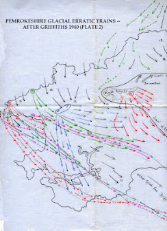
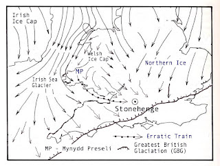
In Chapter 2 Pitts describes the work of HH Thomas in identifying the approximate provenances of the known Stonehenge bluestones.  He mentions Thomas's assertion that the glacial transport of the stones was "contrary to all sound geological reasoning" on the grounds that a glacier could not have selected all those stones from such a small part of Wales and no other parts, and that it could not have done that without dropping any of the stones along the way.  Pitts then takes on board the HHT contention that human agency was the only realistic option available.  However, that contention is just as faulty today as it was in 1921. There are around 30 different rock types at Stonehenge, and some of them still have not been provenanced. And nobody can know what might have been dropped by a glacier on the way from West Wales towards Salisbury Plain, because most of the route is now submerged beneath the waters of the Bristol Channel.  Pitts complains that the glacial theory persists, "and the idea receives a disproportionate amount of publicity". He might say that, and I might say something else.  By the time we reach page 32 of the book, we know that science has been abandoned, and that the Stonehenge bluestone myth perpetrated by Parker Pearson and others is going to be forefront and centre of the author's thinking and writing.  And so it proves.

On page 35 Pitts examines the glacial transport theory in a little more detail, mentioning the claimed lack of "the appropriate Welsh stones" in Wiltshire river gravels and the lack of larger Welsh erratics scattered about across Salisbury Plain. He might have mentioned that Chris Green's pebble counting exercise was so crude that it was very unlikely to have turned up any erratic material from the west, and that there are abundant erratics (admittedly small ones) scattered across the Stonehenge landscape, as pointed out by Olwen Williams-Thorpe and others over 30 years ago. It is perverse to assume that all of these have come from the destruction of Stonehenge bluestone monoliths.  Pitts then says that "not one quern, post or chip of gravel made from Preseli stone has ever been found outside Wales."  That is incorrect.  There are at least 12 Preselite axes in southern England, and they are more likely to have been made from dolerite erratics than from quarried stone in Mynydd Preseli.  And there are dolerites, rhyolites and tuffs in the erratic collections from glacial deposits and shoreline situations in Somerset, Devon and Cornwall;  does Pitts have privileged information that not one of these has come from the Preseli area?  Further, vast tracts of Salisbury Plain and the Stonehenge landscape have never been systematically explored as part of a research programme on Quaternary deposits.  Finally, where does the idea of "appropriate Welsh stones" come from? Has somebody decided that some erratics are appropriate, and others not?

On p 38 Pitts continues in similar vein, and adds that "an ice sheet crossing south Wales would have brought a greater variety of rocks than is seen at Stonehenge."  How many different rock types would it take to convince him that maybe a glacier was involved?  He lists around 16 different rock types from the researches of Bevans and Ixer, and seems to think that there must, therefore, have been 16 different quarries; but if he had read their papers properly he would have discovered that within those broad rock categories there are significant lithological variations that point to several different provenances.  If you look at the number of tock types in the Stonehenge bluestone assemblage (including the debitage) that must have come from different locations, the total is currently around 30. Some of those are from hard rock types, and others are "soft".   It is absurd to think that each of those provenances or locations must have had a dedicated "bluestone quarry" operated by our Neolithic ancestors.

Nowhere in the text, as far as I can see, is there an explanation as to why sarsen stones that littered the landscape were deemed acceptable by the builders of Stonehenge, whereas the bluestones were only deemed acceptable if they actually came from quarries.  Nor is there any recognition that the shapes of most of the bluestones (highly abraded boulders and slabs) indicate that they are classic glacial erratics, and that they cannot have been quarried from places like Rhosyfelin and Carn Goedog.

Then there follows (from p 40 onwards) an extended homage to Ixer and Bevins and the 30 or so articles (some in learned journals and some for "popular" consumption) produced over the last 12 years.  Many of these papers are compromised by confirmation bias, since from the beginning of their partnership the two geologists have portrayed their work as a component in Mike Parker Pearson's "bluestone quarry" hunt. Pitts provides three tables on which rock types are listed, together with Bevins / Ixer designations and source locations. But there is no scrutiny of any of the geological research; it is simply assumed that everything the two geologists say is correct.  If only things were this simple!  For example, I know of dolerite outcrops that are unmapped and unsampled.   If one reads the papers carefully, the authors are much less precise in their provenancing than Pitts pretends, and the idea that provenancing is accurate to within a few square metres at Rhosyfelin is ridiculed by all of the geologists with whom I have discussed this matter.  Suffice to say that Ixer and Bevins have made progress on finding approximate provenances for some of the Stonehenge bluestones and debitage fragments, but not one of them is certain or safe.  The density of their sampling points in the field is nowhere near high enough to satisfy "confidence" requirements.  Too little sampling and too much hubris.

On p 50 Pitts claims that there was "very localised Neolithic targetting of bluestone occurrences" in Preseli.  There is no solid evidence to back up that claim; it is simply a speculation.

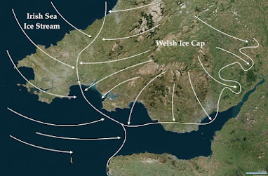
On p 52 Pitts says that because two of the Palaeozoic sandstone bluestones at Stonehenge came from two different places, it would have required two different glaciers to have carried the stones eastwards.  He also seems to think that a final nail is driven into the glacial coffin by the occurrence of both soft stone and hard stone at Stonehenge in the bluestone assemblage.  This is more than a little embarrassing.  All I can say is that Pitts shows no understanding at all of how glaciers work, and that he should have read my chapter on the work of ice (in my Stonehenge Bluestones book) rather more carefully.  At the very least, he should have taken advice from a glacial geomorphologist who knows the territory.

Chapter 3, dealing with the sarsen stones, goes over a lot of familiar territory, but because Pitts knows more about the sarsens than he does about the bluestones he is less inclined to accept the proposals made by experts and the extravagant claims contained in other people's press releases.  The chapter is measured and informative, and (as expected) concentrates on the work of Prof David Nash and the provenancing work leading to West Woods.  This chapter was probably written before the publication of the 2021 Ixer /Bevins article on sarsen provenancing, and it maintains the nuanced view that the Stonehenge sarsens have come from many locations, including the Marlborough Downs and the immediate neighbourhood.

By the time we get to Chapter 4, on Logistics,  Pitts has decided that the glacial transport hypothesis is already disposed of, and throws in references to quarries and quarrying with gay abandon.  So from here on in, confirmation bias is more and more apparent in the text.  The author even invents a "sandstone quarry" designed to provide the Stonehenge builders with an Altar Stone.  This is a pity, because just when we could have done with some academic rigour, it disappears, to be replaced with fantasies about rafts, bronze age boats, sledges, trackways, rollers, levers and ropes.  Much reference is made to stone-moving operations in Indonesia, Madagascar and elsewhere, and this provides opportunities for some striking illustrations to be incorporated in the text. There are references to assorted "experimental archaeology"efforts to move large stones over short distances on nice grassy surfaces, but overall, as with all book chapters on bluestone and sarsen haulage, there is a failure to confront two basic issues:  the lack of hard evidence on the ground for stone haulage even in the vicinity of Stonehenge, and the sheer physical difficulty of moving irregular blocks of stone weighing up to 8 tonnes through the wet trackless jungles, bogs and steep-sided valleys of Neolithic South Wales.  Some cost-benefit analysis would have been welcome.  On the bluestone front, the time / manpower / technical costs of moving 80 or so boulders or monoliths from West Wales to Stonehenge would have been enormous unless the stones were accorded an even higher spiritual or ritual significance.  And as I get rather tired of repeating, there is no sign anywhere in the prehistoric record for Southern Britain that spotted dolerite, foliated rhyolite or any other bluestone type was accorded any significance whatsoever.  In Pembrokeshire these rock types are used more or less at random in megalithic structures, alongside anything else that happened to be handy at the time. This is a point that Pitts completely ignores, while he presses on blindly with the perpetration of the bluestone myth.

Chapter 5 deals with the imagined construction of "Bluehenge" (not to be confused with MPP's Bluestonehenge"), deemed to be the first stone monument, dated to c 3200 BC.  in a somewhat romanticised and simplistic description on the "quarries" at Rhosyfelin and Carn Goedog, Pitts speculates that the unspectacular nature of the rock outcrops at these sites may explain why they had "accumulated histories" that "gave them something special".  This is such a bizarre and naive line of reasoning that it becomes rather charming!  At any rate, there is a completely uncritical acceptance of some of the more outrageous claims of Ixer, Bevins and Parker Pearson relating to quarries, "almost impossible provenancing", hazel nuts, stone trestles and so forth. To confound the deceit, Pitts then repeats some of the claims made about so-called quarrying traces at Carn Menyn (Carn Meini) by Tim Darvill and Geoff Wainwright. We are all aware that popular books tend to simplify things, but Pitts chooses to ignore the fact that every aspect of the quarrying hypothesis has been challenged in the literature.  There is a major scientific dispute going on before his eyes, and Pitts chooses to simply bury his head in the sand.  That in itself is enough to devalue this book and turn it into yet another bland repetition of the Bluestone Myth.

The bulk of Chapter 5 consists of a fanciful narrative describing the imagined route used to carry 80 or so bluestones from Rhosyfelin and Carn Goedog towards Stonehenge.  We can ignore all of this, since there is no evidence in support of any aspect of the story -- but Pitts is quite undeterred, and develops the idea that if people can move stones through forests with primitive methods in Indonesia and elsewhere, they probably did it here too.  As for Waun Mawn and its "lost circle", Pitts swallows that one too, hook, line and sinker, and tells the story as elaborated by Parker Pearson on the telly, as if it is firmly established as the truth.  That is in spite of Pitts being fully aware that the evidence for a ring of standing stones -- even partially complete --  is so thin as to be laughable. 

There is yet another aspect of the work at the "quarrying" sites and at Waun Mawn that Pitts deliberately misrepresents.  He pretends that the narrative developed by Parker Pearson is fully supported by radiocarbon dating work. In fact the radiocarbon dates from all three sites is so inconclusive, with such a wide spread of "inconvenient" dates, that the quarrying hypothesis and the lost circle hypothesis are both falsified.  All the dates show is that there is a long history of intermittent occupation across the whole landscape of northern Preseli -- but we knew that already. 


The new Pitts book: too much mythology, too little science


 "How to build Stonehenge", by Mike Pitts. 2022.  Thames and Hudson, 249 pp.

REVIEW

This book has been anticipated for some time, so it's good to see it in print at last.  It's attractively presented and lavishly illustrated, currently in hard cover only, printed on bulky paper which is not very friendly for monochrome photos, but with two built-in sections of good colour photos.  The writing style is informal and chatty, rather like that of Mike Parker Pearson in his 2012 book on Stonehenge.  And it's very much a "people centred" book, devoting much space to the heroic individuals who have, in their various ways, contributed over the years to answering the questions "How were the stones obtained and transported?" and "How were they shaped, raised and arranged?" The author makes are frequent references to his old mates Mike, Rob, Richard and Dave, and is determined not to upset any of them.   So the book is  heavily biased from the outset, with the author choosing to subject the conclusions of some authorities (such as Kellaway) to heavy criticism, and the conclusions of others (such as Ixer and Bevins) to no scrutiny at all.  And of course bluestone quarries are mentioned in the Preface, signalling the assumption, right from the outset, that they actually existed.

The layout of the book is clear and simple.  Chapter 1 describes the current setting of the stones.  Chapter 2 is titled "Raw materials: bluestone."  Chapter 3 deals with sarsen stone and Chapter 4 with logistics.  Then we see Chapter 5 on the construction of "Bluehenge" (deemed to have come first, based upon the arrival and use of the bluestones) and Chapter 6 on the construction of the sarsen monument.  Finally there's a chapter on "Afterlife", dealing with all the things that have happened to the ruinous old monument since it fell out of use.

A new book on Stonehenge, if it is to be taken seriously, needs to be authoritative, balanced and entertaining.  As far as this one is concerned, its chatty style makes it easy to read,  but in other respects it falls far short of expectations.  Its strength might have been that it deals with bluestone origins, transport and use in much greater technical detail than many other books, but the bluestone chapters reveal that the author knows very little about the source areas of the bluestones, very little about geology, glaciology or geomorphology, and very little about the scientific method.  His dismissals of the glacial transport hypothesis are based on misunderstandings of the workings of glaciers and the events of the Quaternary, and on research findings that are 30 years out of date.  He says nothing at all about glacial entrainment, transport mechanisms or deposition.   Once he disposes -- in his own mind at any rate -- of the glacial transport hypothesis,  by the end of Chapter 3, he concentrates on a protracted reiteration of the "bluestone myth", with one assertion after another dressed up as established facts. The lack of critical scrutiny is -- to put it mildly -- somewhat irresponsible.  So the claims about bluestone quarries at Carn Menyn, Carn Goedog and Rhosyfelin are repeated as if they are facts, and there is no mention of the fact that they are hotly disputed in the literature and on social media. 

Pitts notes, somewhat complacently, that there is no field evidence of glaciation on Salisbury Plain, and on that basis the glacial transport thesis is dismissed.  It all depends what you count as evidence; from where I stand, a rude assortment of abraded and weathered boulders and slabs in the bluestone circle at Stonehenge, and debris of around 30 different rock types scattered all over the Stonehenge landscape, are highly suggestive of glacial activity. Only a small percentage of that landscape has been investigated, but new material keeps on appearing. Not so far to the north, around West Kennet, everybody has been surprised by the appearance of debris from a rotten granite boulder that appears to have come from Cheviot.......  

On the other side of the coin, Pitts fails to draw attention to the fact that when it comes to field evidence, there is none whatsoever which might confirm the reliability of the human transport hypothesis. Citing parallels from Indonesia, Madagascar and India is very jolly, but of questionable relevance to Neolithic Wales. The assumption that something could have been done does not mean that it was done.  Indeed, from the accumulated evidence of West Wales archaeological research, neither spotted dolerite or foliated rhyolite is used preferentially in megalithic monuments, and claims that those stones were special or significant in some way are simply worthless speculations.  Pitts appears to miss the irony of claiming that the sarsens built into Stonehenge were simply picked up from where they were found, whereas the bluestones needed to be quarried.  The absurdity of the quarrying hypothesis is compounded by the fact that the Preseli landscape is littered with erratic and local boulders, slabs and pillars of many different rock types, just waiting to be selected and collected.  But Pitts is so taken with the quarrying hypothesis that he seems to think that there must have been a quarry for every single bluestone type found at Stonehenge. 

Among Pitts's other assumptions, he accepts that Stonehenge was actually completed according to some grand design, with various rearrangements.  That, in my view has never been adequately demonstrated.  He does not even consider the possibility that Stonehenge was built because that is where the stones were, maybe because that would make the narrative very boring.  He accepts the Ixer / Bevins spectacular and frankly preposterous claim that they have provenanced some Stonehenge rhyolite debris "to within a few square metres" at Rhosyfelin. He sidesteps the fact that there are NO foliated rhyolite monoliths at Stonehenge.   He accepts that the abundant radiocarbon dating evidence from the so-called quarries supports the quarrying hypothesis, whereas in reality the dates simply falsify it.  He accepts that there was a "lost stone circle" at Waun Mawn, whereas the field evidence from three years of excavation there is so thin as to be effectively worthless.  He accepts that a required number of bluestones was determined by somebody or other, and duly delivered. He accepts that the bluestones were hauled overland in a heroic feat of logistics (although he does at least acknowledge that others prefer the maritime route).  And in a wondrous feat of intellectual gymnastics, he even suggests that Rhosyfelin and Carn Goedog were accorded significance in Neolithic times largely because they were so insignificant in the landscape.....   The nice thing about an enthusiastically narrated fairy tale is that ANYTHING is possible!

Overall, this is a deeply flawed book that is less technical and scientific than it might have been, and turns out to be yet another exercise in the promotion of the modern Stonehenge myth.  The author fails to take the opportunity of recognising that many of the accepted components of "the Stonehenge narrative" are hotly disputed.  That, after all, is something that should surely be applauded as a sign of a vibrant scientific debate.  Instead, Pitts opts for simplicity, slipping complacently into the comfort zone and spending the bulk of the book elaborating on the  fantastical narrative as approved by EH and certain senior archaeologists.  That narrative, as we all know, has been designed for marketability rather than for scientific credibility.

=================

PS.  I have to declare an interest in reviewing this book by Mike Pitts!  I have of course written a book myself, called "The Stonehenge Bluestones".  I don't see it as a rival to the Pitts book, since it has a narrower and more specialised focus.  But in my book I do at least admit to scientific disputes where they occur, scrutinise the detailed academic literature, and devote considerable space to describing and analysing hypotheses which I do not personally find very attractive. 


Friday 18 March 2022

No settlements = No quarries


Carn Goedog and the rocky slope beneath the tor summit.  The "quarryman's village" was thought to be at the foot of the slope, near the right edge of the photo.


Medieval house platforms at the foot of Carn Goedog -- now interpreted as belonging to a medieval hafod or cluster of houses occupied seasonally.  

I have not made an issue of this before now, but if there were Neolithic quarries buzzing with "industrial scale" activity at Rhosyfelin and Carn Goedog, as MPP would have us believe, why are there no traces at all of "quarrymens' villages"??

This question came into my mind when I did the post yesterday about Foel Drygarn -- a site where thousands of tonnes of stone have been moved and where we can see the source of some of it.  The quarry at the foot of the rhyolite crag was the place where stone slabs and lumps were collected from scree and maybe broken from the living rock.  But at Foel Drygarn there was a village, with 270 house sites identified by archaeologists.  Let's assume that half the houses were occupied at any one time; so 135 dwellings. That means an active population of maybe 270 people, at two per household.  That number could have built the Bronze Age burial mounds and the defensive embankments that enclosed the village.

The builders of the fortified settlement on Carningli, who built the very substantial defensive ramparts, must have lived in the Carningli village, where there are many hut traces that have survived to this day.  BronzeAge or Iron Age?  Maybe some of the traces may be even older.  

Other big prehistoric civil engineering projects that would have required large work-forces were also linked to known settlement sites.  Think Stonehenge and Durrington, or Newgrange, Knocknerea and Mullaghfarna in Ireland, Carn Brea in Cornwall, or Skarabrae in Scotland.  In the Neolithic there were no proper villages, but there were small clustered settlements -- most of them seasonally occupied, but some apparently permanent:

https://d1wqtxts1xzle7.cloudfront.net/45426841/A_Consideration_of_Villages_PPS-with-cover-page-v2.pdf?

"A Consideration of Villages in Neolithic and Bronze Age Britain and Ireland"
Stuart Rathbone
Proceedings of the Prehistoric Society 79, 2013, pp. 39–60 & The Prehistoric Society doi:10.1017/ppr.2013.2 First published online 3 May 2013

Quote:
"A Beaker period settlement was found on Ross Island, Co. Kerry, adjacent to the well known early copper mine. Excavations revealed ten or 11 hut foundations, 13 concentrations of stake-holes belong- ing to arrangements of ‘unknown’ type, and plentiful evidence of contemporary metal working activities (O’Brien 2004, 170–303). Occupation at the site began between 2400–2200 BC and perhaps lasted for several hundred years, but it is suspected these structures belong to a single phase within the overall site chronology. O’Brien is careful to call the settlement a work camp, and goes on to stress the transient nature of mining communities (ibid., 303, 475–7). However there was no direct evidence of seasonality and it remains a possibility that this site may be an early mining village."

In his article, Rathbone makes an interesting suggestion that some early villages or small settlements were created because they were associated with "projects" of a ritual nature that required substantial manpower, at a time when chiefdoms were beginning to exert some social and "political"control.

Back to the so-called Neolithic quarries of Carn Goedog and Rhosyfelin.  As we know, Parker Pearson and his fellow researchers were greatly enthused at one stage by the thought that there was a "quarryman's village" at the northernmost edge of the dolerite tor.  If the settlement site had turned out to be Neolithic, that would of course have greatly reinforced the quarrying hypothesis, since a quarry dedicated to the extraction and export of monoliths weighing several tonnes must have required a substantial and settled work-force over a considerable period of time.  How many workers?  Twenty?  A hundred?  I would go for the latter, since the  complexity of the civil engineering processes discussed by MPP et al (including ramps, revetments, platforms, levers and wedges, trackways, storage areas, and so forth) must, if it ever happened, have required substantial organization, team work and muscle power.  At Carn Goedog MPP has referred to quarrying "on an industrial scale".  Too much purple prose, as usual.  But a quarry with a village next door would have made a wonderful addition to the bluestone myth -- and MPP must have been mortified when the "village" turned out to be medieval, and not Neolithic.

https://brian-mountainman.blogspot.com/2016/08/bang-goes-carngoedog-neolithic.html

http://eprints.bournemouth.ac.uk/31410/1/09-Arch_Camb167_Schlee%20et%20al_245-255.pdf

Archaeologia Cambrensis 167 (2018), 245–255
Carn Goedog medieval house and settlement, Pembrokeshire
By DUNCAN SCHLEE, RHIANNON COMEAU, MIKE PARKER PEARSON and KATE WELHAM

So my point is this.  Quarrying activities, if they ever happened, at Rhosyfelin and Carn Goedog, were so complex, and so invested with spiritual or ritual significance in the MPP narrative that they must have required a settled and dedicated work-force with stone-working skills, living in a tight community.  After all, if he refers to quarrying "on an industrial scale" he has to support that claim. The quarry workers and their families must have lived very close to their places of work.   No trace of  a community or settlement site has ever been found in the vicinity of Carn Goedog or Rhosyfelin.  That's not surprising, since the quarries are in any case simply the products of an over-fertile imagination.


Carningli -- big project >> big labour force >> big village


Foel Drygarn -- big project >> big labour force >> big village


St David's Head -- modest earthworks >> modest labour force >> small settlement

Thursday 17 March 2022

Foel Drygarn prehistoric quarrying


A fabulous photo from Serena Davies (on Facebook) reminded me that at the foot of the crag in the middle distance is a perfectly splendid prehistoric quarry. It has all the characteristics one would expect of a quarry -- worked faces, trackways, piles of rubble left behind, suitable rock type etc.  It's probably a Bronze Age / Iron Age feature, and it was used for the provision of lumps of rock and slabs used for the creation of the Foel Drygarn burial mounds and for the embankments of the fortified settlement on the hill summit.  It was not used for the extraction of monoliths, but for lumps or rock that could easily be carried by one or two men.

I have described the quarry (or quarries) here:

https://brian-mountainman.blogspot.com/2017/04/foeldrygarn-prehistoric-quarries.html

https://brian-mountainman.blogspot.com/2018/10/the-prehistoric-quarries-at-foel-drygarn.html

I mention this just in case anybody should think that I have an obsession with proving that prehistoric quarries did not exist anywhere!  This one is very convincing, but intriguingly it is hardly ever mentioned by archaeologists. 

When it comes to Carn Meini, Carn Goedog and Rhosyfelin, I still maintain that the "evidence" for quarrying at those sites has been entirely fabricated by archaeologists with vivid imaginations.


The three burial mounds and the fortified embankments at Foel Drygarn.  The quarrying for stone was done beneath the crags at bottom left.


Rock surface dating -- Pitts has got it wrong


Rhosyfelin following the discovery of the cracked rhyolite monolith and accumulated rockfall debris. There are abundant opportunities for rock surface dating here and at Carn Goedog, designed to test the quarrying hypothesis.  In spite of Pitts's contention, it is perfectly feasible to demonstrate quantitative differences in the weathering and exposure time of many different rock surfaces as shown in the photo.


I have been looking at Mike Pitts's new book called "How to build Stonehenge", and will do a review in due course.  But given the theme of my last two posts, here are a few thoughts on rock surface dating.

Mike says this when referring to bluestone monoliths:

"Stone - except in special circumstances that do not apply here - cannot be dated to show when it was worked." ........... "For that we rely on radiocarbon dating of associated organic material"……..

Wrong.   If a stone monolith in the shape of a pillar or column has been quarried, there might be one (outward facing) face that might be weathered, but the other three faces should be relatively fresh.  They would not be completely unweathered, because rock generally breaks off along pre-existing fractures, which are always characterised by localised shallow weathering.  But there should be a substantial difference between the outward face and the others, which would be measurable via cosmogenic dating or Schmidt hammer dating.  If a stone has been worked or dressed after being collected, the dressed faces should give readings that are different from (ie younger than) the undressed faces.

As long as a rock surface has been exposed for more than a thousand years, cosmogenic nuclide dating should work.  So if, as has been claimed, a monolith was quarried 5,500 years ago, you should be able to show that fact, as long as the surface of the monolith has been exposed continuously between then and now — which has to be assumed. Otherwise what would be the point of quarrying it in the first place?

The claim that (for quarried blocks) we have to rely on the radiocarbon dating of associated organic material does not hold water.  MPP and his colleagues have tried to convince us on that score both at Rhosyfelin and Carn Goedog, with disastrous results.  The vast random scatter of C14 dates, spread over many thousands of years,  at both Rhosyfelin and Carn Goedog, effectively falsifies the quarrying hypothesis, and no amount of "selective sample citation" can alter that. It's not just me saying that; almost all of those scientists I have spoken to who have scrutinised the presented evidence draw the same conclusion.

The quarrying hypothesis is so bizarre and so extraordinary that nobody should be expected to accept it without the provision of extraordinarily powerful field evidence.  That powerful evidence has never been provided, which is why no geomorphologist has gone on the record as supporting the existence of the quarries.   If MPP and his geologist colleagues want to prove their hypothesis they need to get some proper stone surface dating work done.  If they need any help, I will be delighted to offer my services..........

===============

Thinking about my qualifications on the research front, I was amused to see that Mike refers to me in his book as "a geomorphologist (and a novelist) with a glacier named after him in Antarctica".  In the next sentence, he implies that I specialise in rhetoric.  That, if I may say so, is more than a little condescending.   I'm a glacial geomorphologist by training, and although my conventional academic career was rather short, John Glacier was named after me by the Antarctic Place-names Committee in recognition of  my contribution to polar research in the field of glaciology and glacial geomorphology, and for my published output including the highly influential text (written with David Sugden) called "Glaciers and Landscape."   Certain archaeologists and geologists may choose to pretend that I don't exist, but I know what I am talking about.


Bluestones and sarsens at Stonehenge.  Some are worked, and others are not.  Rock surface dating can reveal which faces are fresh and which are very old.  Most of the bluestones in the bluestone circle are boulders, probably glacial erratics,  probably exposed to the atmosphere for hundreds of thousands of years.  We all need that hypothesis to be tested.......


Bluestone 37 (courtesy Simon Banton)


Dolerite boulders in the wild, near Glan yr Afon


Dolerite outcrops at Carnedd Meibion Owen, near Brynberian.  Do these rocks have similar exposure ages to the erratic boulder assemblages at Glan yr Afon and Stonehenge?  


Wednesday 16 March 2022

Schmidt Hammer Exposure Dating


Schmidt Hammer exposure dating (SHED) (sometimes called SHD) is another technique coming into its own -- particularly valuable because it is non-invasive, meaning it does no damage at all to the dated rock surfaces.  Putting it crudely, the instrument measures a "rebound value" for each reading which is related to rock coherence or hardness.  The principle is that as rocks are exposed to the atmosphere over time, weathering sets in, during which the surface is rotted or softened because certain crystals break down either quickly or slowly.  Every rock type will have its own "rotting rate" which can be calibrated via many measurements.  Ten readings should be taken from each sampled area, and an essential feature of the method is that there has to be a "control surface" of a known age, against which all other readings can be calibrated.  The method is very quick and not all that accurate, but if carefully used it provides a useful guide to the relative ages of rock surfaces of interest -- and most researchers suggest that preliminary work using SHED can and should be followed up with more accurate cosmogenic dating methods.


The method does not seem to be suitable for sandstones or tuffs -- and maybe not for rhyolite either -- but for dolerites it should work well as long as internal lithological variations are taken into account.

Here is one of many papers that have been devoted to this method.

==================


Schmidt Hammer exposure dating (SHED): Establishment and implications for the retreat of the last British Ice Sheet
Author links open overlay panelM.D.Tomkins, J.M.Dortch, P.D.Hughes
https://doi.org/10.1016/j.quageo.2016.02.002
See also:
M.D. Tomkins, J.M. Dortch, P.D. Hughes.  Erratum to: “Tomkins et al. (2016) Schmidt Hammer exposure dating (SHED): Establishment and implications for the retreat of the last British Ice Sheet” [Quat. Geochronol. 33 (2016) 46–60]
Quaternary Geochronology, Volume 38, March 2017, Pages 75-76


Highlights

Robust SHED calibration curve (R2 = 0.81, p = < 0.01) for granite surfaces.

SHED not appropriate for sandstones, quartz, gneiss, and tuffs.

SHED ages match precision for TCND.

Shap deglaciation occurred at 16.5 ± 0.5 ka.

SHED can provide a cost efficient alternative to TCND.


Abstract

Ninety-eight surfaces related to the retreat of the British Ice Sheet (BIS) and dated using Terrestrial Cosmogenic Nuclide Dating (TCND) were sampled using the Schmidt Hammer to expand on relative dating techniques and establish Schmidt Hammer exposure dating (SHED) as an effective method for dating glacial landforms in the UK. The BIS is an effective analogue for contemporary glacial systems but our understanding of its retreat under changing climate conditions is constrained by a limited number of dates obtained from existing methods (14C, OSL). These methods are restricted in their application to glacial environments and while TCND has addressed this to some degree, its cost and potential for outliers encourage the establishment of new techniques. SHED fulfils this requirement by providing a cost-efficient method for obtaining numerous direct ages that are of comparable accuracy and precision to TCND. A multi-lithology approach has established that many rock types are unsuitable for numerical dating. However, a robust calibration curve was generated (R2 = 0.81, p = < 0.01) for granite surfaces and applied to 31 undated granite erratics on Shap Fell, NW England. SHED indicates that BIS retreat occurred at 16.5 ± 0.5 ka, a conclusion which supports our current understanding of regional deglaciation and indicates that SHED can be a valuable and cost-effective geochronological tool.


Exposure-age dating


As readers will know, I have been interested in cosmogenic dating methods for some time, and remain convinced that "exposure age dating" holds the key to unlocking "the problem of the bluestones."  Not just that, but the problem of the "bluestone quarries" as well.  Some years ago, samples were taken from Rhosyfelin for cosmogenic dating,  but I have never been able to get a satisfactory answer when I have enquired what happened to them, and what the results were.........  anyway, nothing has ever been published, and those who enjoy conspiracies may wish to think that this means that the findings were extremely inconvenient!  From what I can gather, the sampling was somewhat disorganized anyway. 

Back in 1994 Prof David Bowen caused quite a stir when he published some Chlorine 36 exposure dates for rock fragments from Stonehenge and Carn Meini, but his paper was slammed by Olwen Williams-Thorpe and others because no adequate information was ever published as to the sampling locations and procedures -- so the dates were essentially worthless.

If somebody with funding in the bag was to offer me the opportunity, I would happily get involved in a project designed to date the surfaces of the bluestones at Stonehenge and at the "quarries" -- which will almost certainly reveal surface exposure ages far in excess of the 5,000 BP which might be expected if the stones were selected and quarried from "significant" locations.


http://brian-mountainman.blogspot.co.uk/2011/03/glaciation-of-carningli-dating-problem.html


https://brian-mountainman.blogspot.com/2011/11/those-famous-chlorine-36-dates.html

Anyway, I came across this summary written by Bethan Davies, which explains simply and concisely what the technique is all about.

======================


Cryospheric Geomorphology: Dating Glacial Landforms II: Radiometric Techniques


Bethan J. Davies, in Reference Module in Earth Systems and Environmental Sciences, 2021

https://www.sciencedirect.com/topics/earth-and-planetary-sciences/glacial-transport
3.4.1 Exposure-age sampling methodologies

Sampling strategies for exposure-age dating will depend upon the research objectives, the rock type and target minerals available and resultant choice of isotope, and the local environment. Researchers should in all cases aim to collect multiple replicate samples where possible, especially in the case where a particular landform (such as a moraine) is to be dated. A fundamental knowledge of the principles of the six cosmogenic nuclides is required in order to design such a sampling strategy. Fundamentally, the sample should contain sufficient target mineral to obtain measurable quantities of the required nuclide.

Careful geomorphological mapping is critical to understand the depositional processes affecting boulders and any post-depositional modification (e.g. Kelley et al., 2014; Koffman et al., 2017; Schaefer et al., 2009). For example, it is important to understand the relationship between moraines, boulders, slope processes and any ice-dammed palaeolakes, as boulders deposited below lake water will have an exposure age that records the timing of lake-level fall, rather than deglaciation (Davies et al., 2018, 2020; Hein et al., 2010; Thorndycraft et al., 2019).

Boulders should only be sampled if the operator can be sure that they were glacially transported, and not deposited by rockfall or other geomorphic processes. Both bedrock and glacially transported boulders should show signs of glacial transport, abrasion, and erosion (faceting, striations, polish, edge-rounding, of a erratic lithology), so that any inherited nuclides have ideally been removed. Multiple boulders should be sampled per moraine, as geological scatter is a common issue in exposure-age dating. This is because moraines degrade over time, and boulders can be weathered away, exhumed, buried, or destroyed by erosion. They may have an inheritance, with cosmogenic isotopes dating from a prior exposure. This can lead to geological scatter (Applegate et al., 2012; Heyman et al., 2011, 2016). Sampling 3 to 5 boulders for moraines dating to the Last Glacial Maximum or younger can help with identification of outliers (Putkonen and Swanson, 2003). Larger boulders more than 0.5 m above the ground height should be targeted in order to minimize the risk of exhumation and post-depositional processes causing geological scatter (cf. Heyman et al., 2016). Boulders should only be sampled where they are in a stable position in the landscape or on the moraine and there is no possibility that they have rolled, rotated, or otherwise moved significantly since deposition (Fig. 7). For moraines, ideally boulders should be situated on the moraine crest (e.g. Fig. 8).

Cobbles may be sampled where they lie on flat bedrock, and the possibility of cycling through the active layer as a result of periglacial processes can be excluded. Cobbles should be marked with the uppermost surface marked. If they are less than ca 5 cm thick, then attenuation through the sample and self-shielding can be effectively disregarded. Cobbles should however be large enough that they are not moved due to strong winds. They should be sampled from exposed locations where snow cover is likely to be thin or inconsequential. Cobbles should weigh ca 1 kg minimum, so as to increase the likelihood of the required nuclide. They should show signs of glacial transport (abrasion, striations, faceting) and ideally be of an erratic lithology, so that local production of the cobbles can be excluded.

The ideal boulder, rock, landform surface or bedrock surface for sampling should be sufficiently extensive, flat, and horizontal. The angle of the surface will affect the shielding and so should be recorded. Samples should be collected at least 50 cm away from any edges (Gosse and Phillips, 2001). Samples with less topographic shielding are preferable, to avoid the need for additional corrections. Flat surfaces also require fewer corrections for shielding, and so have a greater precision and accuracy. Edges are susceptible to ‘edge effects,’ particularly for nuclides such as 36Cl that are produced by muon capture, as cosmic rays could penetrate from multiple directions. Samples should ideally be taken from the flattest, central, uppermost surface of the boulder, but this can in reality be challenging unless a rock saw or small explosive charge is used. Shielding from snow cover and vegetation can be minimized by choosing boulders that are large and upstanding and above the local topography (e.g. Fig. 8A, B, and F), as they are more likely to be windswept (Gosse and Phillips, 2001).

A thorough sample description is required in order to calculate shielding and production rate scaling. A hypothetical proforma to assist with this is presented in Fig. 7, which follows best-practice guidelines (Darvill, 2013; Gosse and Phillips, 2001). Samples should be sketched, photographed from all angles, and details of location (decimal degrees), elevation (m asl) and geomorphic context should be very carefully recorded. In order to calculate the shielding, the dip and dip direction of the surface and the angle of elevation to the skyline should be recorded at regular intervals. This can be checked with a digital elevation model (DEM) in a geographic information system (GIS) if the horizon is not always visible (Codilean, 2006). The boulder's characteristics should be carefully described, including dimensions and height above ground surface, signs and measurements of weathering or erosion (upstanding quartz veins, weathering pits, flaking), lithology, grain size and quartz content. Sample thickness should be recorded as well.

Samples should be collected with the aim of leaving as little permanent scarring as possible on the landscape. Sampling with a hammer and rock chisel or small charge can be best, as these methods take small flakes and leave little permanent visual impact. Sampling with a rock saw can be easier and quicker, and allows the operator to choose more precisely where to sample, but if this method is used, some time should be spent afterwards to obscure and roughen the straight cuts. Samples should only be taken with the permission of the landowner, and permits may be required in some localities. Ideally, samples should be stored in a durable cloth bag, clearly marked with permanent marker pen.

The volume of sample required depends on the proportion of the target mineral, grain size of the target mineral, and required isotope. Around 1 mg of 10Be/9Be is required for AMS analysis. For 10Be dating of quartz-rich rocks (such as a typical granite, with 10% quartz), a minimum of 500 g but ideally around 1 kg of sample should be obtained. Samples from rocks with a younger exposure age should be larger, to obtain the required level of precision (Gosse and Phillips, 2001). In sample processing, material could be lost due to accidental chemistry, and offcuts may be required for thin section or duplicate chemistry. Larger samples will be needed in rocks with a lower quartz content. 5 kg of rock could be required, for example, for the analysis of fine-grained quartz-poor rocks (ibid). Whole-rock analyses of 36Cl do not require mineral separates, and so smaller samples of 500 g may be appropriate.

Monday 14 March 2022

The Carn Llwyd "Lost Embankment"


 Thanks to Hugh Thomas (of Preseli 360) for allowing me to use this splendid drone image of the strange embankment on the north side of Carningli.  The little dolerite tor of Carn Llwyd is very close -- just off the left hand edge of the photo.  This is the best image I have ever seen of the feature.  I have featured it before, on a number of posts.

The photo shows the summit of a gently sloping hillock or ridge.  As we can see, there are four little segments of an embanked circle, with one of them slightly offset from the others.   It's about 1 m high, and there are traces of a slight ditch on the outside.  So what we are looking at is around 45 degrees of embankment on a circle that -- if it ever had been completed -- would have had a diameter of between 120m and 200m.  There is no trace at all of any other embankment remnants on or near the assumed circumference.

The best guess is that this might have been intended as an embanked and palisaded fortified enclosure designed to contain and protect both human beings and their animals.  Maybe the project was abandoned when the tribal elders decided to develop a fortified "village" right on the summit of Carningli; and we have no idea whether the embanked segments we see today date from the  Bronze Age or the Iron Age (or maybe even Neolithic).

That's all very boring, and is unlikely to satisfy the members of the Stonehenge Bluestone Cult. So Hugh has suggested that maybe this is Pembrokeshire's "Lost Embankment"  -- or all that was left of it after the rest of it was dug up and carted off to Stonehenge to be reconstructed there.  That would have involved rather a lot of sturdy Neolithic tribesmen,  beavering away with their antler picks and shoulder blades over several decades around 5,000 BP, removing the embanked circle bit by bit, and  traipsing off to Stonehenge with their leather buckets filled with sacred soil and rubble.  So why did they do it?  Ours not to wonder why -- we just have to believe, according to current archaeological practice,  that they were intelligent human beings who had their reasons..........  

Sounds absurd, and of course there is no evidence for any of this, but we all love a good story, don't we?  And this is inherently no more absurd that the idea of a lost stone circle at Waun Mawn being dismantled and hauled off to Stonehenge by those selfsame Neolithic ancestors.........

But here's a thought -- Hugh couldn't possibly have been joking, could he...........???


Sunday 13 March 2022

Ilfracombe erratic spread


The plateau behind Berrynarbour -- erratics up to 175m?

I'm intrigued by a statement by Prof Nick Stephens that there is erratic material in the Ilfracombe - Berrynarbour area, on the plateau to the south, up to an altitude of 150 m - 175 m.  This is recorded on p 202 of the 1998 GCR volume on The Quaternary of SW England.  I have not been able to find further information on this -- but it would not surprise me to find erratic boulders and cobbles up there, and Nick Stephens was a very good geomorphologist who would not have said anything without firm evidence.

This of course points to a considerable incursion by Irish sea ice across the Devon coast, thick enough and extensive enough to affect the Barnstaple - Fremington area, the Saunton-Croyde area and to have dumped the Shebbear erratic more than 20 km south of Ilfracombe.  Indeed, it would be extraordinary if this ice did NOT overtop the cliffline and press well inland, since it was able -- on at least one occasion -- to flow over Lundy Island to the west and over the islands of the Scilly archipelago, far to the south. (I demonstrated that in my research on the Isles of Scilly some years ago.)  It also makes sense for Irish Sea ice to have impinged upon Exmoor and to have had an upper surface at maybe 200m, since it did at one time extend another 60 km to the east -- leaving till at Greylake, in the Somerset Levels.


The Fremington erratics


The till sheet (light blue) in the Fremington - Bickington - West Yelland area, on the south side of the Taw estuary.  The area is littered with old clay pits.

This is a key record of some of the erratics found in the Fremington clay pits. Whether or not much of the clay was laid down in a lacustrine environment, the presence of ice here on the Devon coast is no longer a matter of dispute.  The question is -- which glacial episode are we talking about?

SIR,—Erratics associated with the Fremington Clay of North Devon have been described by Maw (1864), Dewey (1910), Taylor (1956, 1958), Vachell (1963), and others. The object of this letter is to put on record what I have learnt locally concerning the stratigraphical position at which some of these erratics were excavated. I wish to express my gratitude for this information, and for all their help, to Mr. A. Hobbs, Mr. W. Prust and the late Mr. C. Green, and a!so to the late Mr. C. W. Taylor.

The Fremington Clay (Maw, 1864) occupies part of a valley west of Barnstaple and opening into the Taw estuary at Fremington Pill; it is generally considered to be of glacial origin, although Balchin (1952) suggested that it was an alluvial infilling of reworked Keuper Marl. Zeuner (1959) believed that it was the bottom-moraine of an ice-sheet which approached Barnstaple Bay from the Irish Sea, so that its existence is the only evidence at present known of an ice-sheet having actually penetrated inland on the south shore of the Bristol Channel. Near Fremington, the Culm Measures are overlain by a bed of gravel above which is clay with stones, and then comes the smooth brown potting clay of variable thickness, up to 21 feet being found in the present pits at Bickington. Above the smooth clay are about 2 feet or more of clay known as " horseflesh ", with small stones and grit and decayed wood; and finally at the surface there is a layer of gravel ranging from a few feet up to 16 feet or more in thickness, from which erratics have also been recorded.

At Combrew Farm (SS(21)524323) near Fremington, the boulder described by Dewey (1910) as a vesicular granophyre and catalogued by Taylor (1956) as erratic No. 6, appears to be the same boulder which Maw (1864) recorded as having been found in isolation in the middle of the clay-bed at Combrew. At Chilcotts Farm (523323), the erratic No. 7 of Taylor (1956), on the gate- post to the right as one faces the house, is evidently the hypersthene-andesite discussed by Dewey (1910), although he described it as having been placed on the garden-wall of Combrew Farm house. Mr. A. Hobbs, of Chilcotts Farm, has told me that this boulder was found by his grandfather about the year 1870, in the clay near by, some 22 feet below the surface of the ground.

I am indebted to Messrs. C. H. Brannam, Ltd., of Barnstaple, for permission to study their pits (SS(21)531318) in Tews Lane at Bickington near Fremington. The late Mr. C. Green, who had worked there since 1920, showed me in 1948 a quartz-dolerite boulder (No. 9 of Taylor, 1956), which he had found many years before in the very middle of the brown clay. In 1957, the present foreman, Mr. W. Prust, showed me a smooth rounded boulder, some 19 inches long, which he had excavated 10 feet below the upper surface of the clay, and in 1957 he found another boulder 16 feet below the upper surface of the clay. Neither of these boulders has hitherto been recorded, nor have they (so far as I know) been identified. In 1962, Mr. Prust excavated another quartz-dolerite erratic, No. 13 of Taylor (Vachell, 1963), about 10 feet from the top of the clay. Since 1956, Mr. Prust has also collected over fifty miscellaneous small pebbles, the majority of which were found at or near the base or the top of the clay; a number, however, were embedded in the clay itself at depths ranging from approximately 5 feet to 11 feet above the base of the clay. Two pebbles found in 1955 about 2 or 3 feet above the base of the clay were described by Taylor (1956) who identified one as an olivine-dolerite.

There is thus first-hand evidence that erratics are actually included in the heart of the Fremington Clay itself. This supports the theory of its glacial origin.


REFERENCES

BALCHIN, W. G. V., 1952. The Erosion Surfaces of Exmoor and Adjacent Areas. Geogr. J., 118, 453-76.

DEWEY, H., 1910. Notes on some Igneous Rocks from North Devon. Proc. Geol. Ass., Lond., 21, 429-434.

MAW, G., 1864. On a Supposed Deposit of Boulder-Clay in North Devon. Quart. J. geol. Soc. Lond., 20, 445-451.

TAYLOR, C. W., 1956. Erratics of the Saunton and Fremington Areas. Rep. Devon. Ass. Adv. Sci., 88, 52-64.

1958. Some Supplementary Notes on Saunton Erratics. Ibid., 90, 187-191.

VACHELL, E. T., 1963. 5th Report on Geology. Rep. Devon. Ass. Adv. Sci., 95, 100-7.

ZEUNER, F. E., 1959. The Pleistocene Period. London.


18 SHERLOCK CLOSE, CAMBRIDGE.

8th March, 1964.


MURIEL A. ARBER.

https://www.cambridge.org/core/services/aop-cambridge-core/content/view/B34A6E72966498B37FB95BE11B3CB6B5/S0016756800049517a.pdf/erratic_boulders_within_the_fremington_clay_of_north_devon.pdf 

From Wikipedia:

The clay may have formed in varve lakes, near an ice deposit which lay over Fremington during the Last Glacial Maximum or previous glaciations such as the Anglian (MIS12) or the Wolstonian glaciation (MIS6).  Unusually, glacial deposits are found here in the county of Devon. Two patches of boulder clay lie over the centre of the parish's bedrock. The next nearest boulder clay deposits are in the Gower Peninsula, South Wales, approximately 45 miles (72 km) due north of Fremington across the Bristol Channel. The nearest deposit of boulder clay in England is in the central Cotswolds, 6 miles (10 km) due east of Bourton-on-the-Water and approximately 140 miles (225 km) north-east of Fremington. The existence of the boulder clay is puzzling as the southernmost limit of the Devensian glaciation is believed to have been located over South Wales. There are few other signs of glaciation in North Devon to support this.  However this does not fully explain the presence of the nearly co-located varve clay beds.

That Wikipedia entry is somewhat dated. There is of course till or boulder clay much closer than the central Cotswolds -- in the Gordano Valley and other sites in the Bristol - Bath area.    And the idea of an ice mass that "drifted across the Bristol Channel" is rather charming in its naivety!

Never mind -- the Fremington area ids now quite well studied, and there is a sizeable entry in the Geol Cons Review book on  The Quaternary of SW England (1998) (pp 193-246) by Prof Nick Stephens that leaves us in no doubt that we are dealing here with glacial features in abundance that cannot be dressed up as anything else.  And if -- as seems likely from some of the more recent dating work -- they are not of Devensian age,  they must be Anglian or older.  

Wednesday 9 March 2022

The Mumbles giant erratic -- progress report


There is good progress on the analyses of the two samples (one sample originally, but cut up to eliminate weathered material and to allow analyses using two different techniques, in different labs) taken by Phil Holden from the famous erratic which he discovered in Limeslade Bay.  (Actually Rob Ixer claimed that we were lying when we said we had said we had sampled the erratic -- which was really rather silly of him.  What would be the point misleading anybody on this?  But one gets used to a certain amount of silliness in all things pertaining to Stonehenge.........)

Anyway, the work is going well, and we should soon be in a position to see the geology reports.

On a related matter, I notice that there have been 1353 reads of this post on the blog:

https://brian-mountainman.blogspot.com/2022/02/the-mumbles-giant-erratic-sound-and-fury.html

In general, I count 500 reads as a "popular post" -- so there seem to be rather a lot of people who are showing an interest in this one, in spite of Rob Ixer pretending that it was all much ado about nothing.

And what intrigues me even more is the fact that the Limeslade giant erratic, on the edge of the Gower,  is on the other side of the Bristol Channel from that famous assemblage of erratic boulders -- great and small -- around Saunton and Croyde on the North Devon Coast.  That all makes sense -- if the Irish Sea Glacier was pushing eastwards, in one glaciation or several, of course it would have dumped a trail of erratics on both flanks.  But of course most of the erratics will have been dumped in the channel that is now submerged.

The Saunton erratic cluster


The Ramson Cliff erratic, about 80m above sea level.  Since this photo was taken it has sunk more deeply into the undergrowth.......


As we dig deeper into the Quaternary history of the Bristol Channel region, the collection of (mostly igneous) erratics around Croyde and Saunton appear more and more important. As indicated by Keene and Cornford in their booklet called "The Cliffs of Saunton" and Madgett and Inglis (1987) there can be no doubt that the 50 or so erratics described in the literature represent the last remnants of an ancient glaciation. Some of the recorded erratics are quite small, but of the 37 larger erratic recorded in the tables below, there are a number (dolerite, rhyolite, rhyolitic tuff and other volcanics) that could have come from North Pembrokeshire, but the geologists who have looked at them prefer, at the moment, to suggest provenances in Scotland or other northern parts of the British Isles.

https://devonassoc.org.uk/wp-content/uploads/2018/11/A-Reappraisal-Madgett-TDA-1987.pdf

These erratics (including one at about 80m asl) must have been a part of a spread of glacial deposits; they cannot all have been dumped from grounded icebergs or ice floes since at times of cold climate seal level would have been many kilometres away from the present position of the coast.

The glacial episode responsible must also have affected (if not overrun) Lundy Island, and the other islands (including Flat Holm) further up the Bristol Channel. Even if the ice surface gradient was very shallow, ice at the same time must have penetrated eastwards past Ilfracombe, Lynmouth and Minehead, and into the Somerset Levels. It may well have impinged upon the west-facing chalk escarpment of Salisbury Plain. It may of course have coalesced with ice coming off an independent Exmoor ice cap. But in general, it may well be that the North Devon cliffline was the prominent landscape feature that resisted the flow of the Irish Sea Glacier and channelled it eastwards.

https://devonassoc.org.uk/wp-content/uploads/2018/11/A-Reappraisal-Madgett-TDA-1987.pdf


The Ramson Cliff erratic  above the north-facing Ramson Cliff, near Morte Bay, about 150m inland and on the edge of the coastal slope.

About halfway along the north side of Baggy, there is another (smaller) glacial erratic sat right next to the path. It is a 500 kg block of epidiorite of Scottish origin. It is a little difficult to spot, as it is surrounded by gorse, and is slowly disappearing into the surface. Part of the surface has been chipped away, exposing the obvious crystalline structure of igneous rock. It once stood upright in the middle of a nearby pasture field and was used as rubbing post by sheep and cattle. In the early 1970s, the field was ploughed and the rock dislodged and then laid prone. It was then dragged to edge of field where it has been ever since. The erratic can be located at grid reference SS 4356 4070.


Dark coloured crystalline rock (epidiorite) adjacent to coastal footpath at c 80 m asl. 
(Photo: Paul Berry)


Tuesday 8 March 2022

The Baggy Point (Freshwater Gut) giant erratic


Thanks to Paul Berry for this info on a 50-tonner at Freshwater Gut, Baggy Point, near Croyde.  I have featured this erratic in a number of previous posts, but I found this new source of information:

https://www.geographysouthwest.co.uk/wp-content/uploads/2021/10/PTV-Baggy-Point-Erratic.pdf

The Baggy Point erratic is a large granulite gneiss boulder that has been carried by ice from Western Scotland. It weighs some 50 tons, but sea erosion and encrusted lichens make it a little tricky to spot.

The Baggy boulder is one of a suite of over twenty glacial erratics (according to Paul Madgett, there are 37 of them) that can be found along this stretch of north Devon coastline. Two of them are quite accessible (this one at Baggy Point, and another at Saunton are relatively easy to identify, but most of the others are much smaller and quite difficult to find.

As at Saunton, the Baggy erratic sits on a wave cut platform created from the local rocks. At this location, the foreshore consists of Baggy sandstones that overlie the Upcott slates that form Baggy Point itself. These sedimentary beds of mudstones, siltstones and sandstones were formed in the Devonian Period between 359 to 372 million years ago. They were deposited as horizontal layers on the sea bed, but have since been uplifted and contorted, and hardened into vertically aligned layers. The sea has since carved this rock into sharp ridges and ancient fault lines are marked by long, straight and deep gullies, created where less-resistant beds have been eroded at a faster rate.

Behind the erratic boulder is a clear exposure of an old cliff line formed from Pleistocene raised beach material, or sand rock, that was created in the Ipswichian interglacial. This provides clear evidence of how sea levels at this location have been at different heights in the past.

----------------------------

This massive erratic must indeed have been emplaced by ice, but I disagree with Paul on a couple  of points.  First, the shore platform on which the erratic rests has to be older than Ipswichian -- and indeed, evidence from all around the Bristol Channel suggests that although the raised beach deposits may well be of Ipswichian age, the rock platform is certainly older -- and indeed may be a composite feature, cut and refreshed during a number of older interglacial episodes.

Secondly, the idea of emplacement by floating ice is no longer tenable.  An erratic of this size cannot have been transported on slabs of floating sea ice.  It must have been carried either in an iceberg or in a large and deep chunk of brash ice -- and that means deep water.  Deep water cannot have existed here at a time of iceberg transport, because when the Celtic Sea was awash with the debris of glacier disintegration, the sea was not here at all -- it was probably at least 100m lower down, and most of the Bristol Channel was dry land.  

So the erratic must have been dumped from a melting glacier -- but which glacial episode are we talking about?  Anglian?  Wolstonian?  Happisburgh?  The jury is still out.

See also: