THE BOOK
Some of the ideas discussed in this blog are published in my new book called "The Stonehenge Bluestones" -- available by post and through good bookshops everywhere. Bad bookshops might not have it....
To order, click
HERE

Monday 30 April 2018

The Waun Mawn quarrying complex


I spent a long time wandering around on Waun Mawn and Cnwc yr Hydd yesterday, looking at those quarries -- and I am as mystified as ever.  While I am implacably opposed to the idea that there is a "bluestone monolith quarry" at Rhosyfelin, these quarries are so obvious that nobody would seek to pretend that they were created by the forces of nature!

Grid ref:  SN 083345

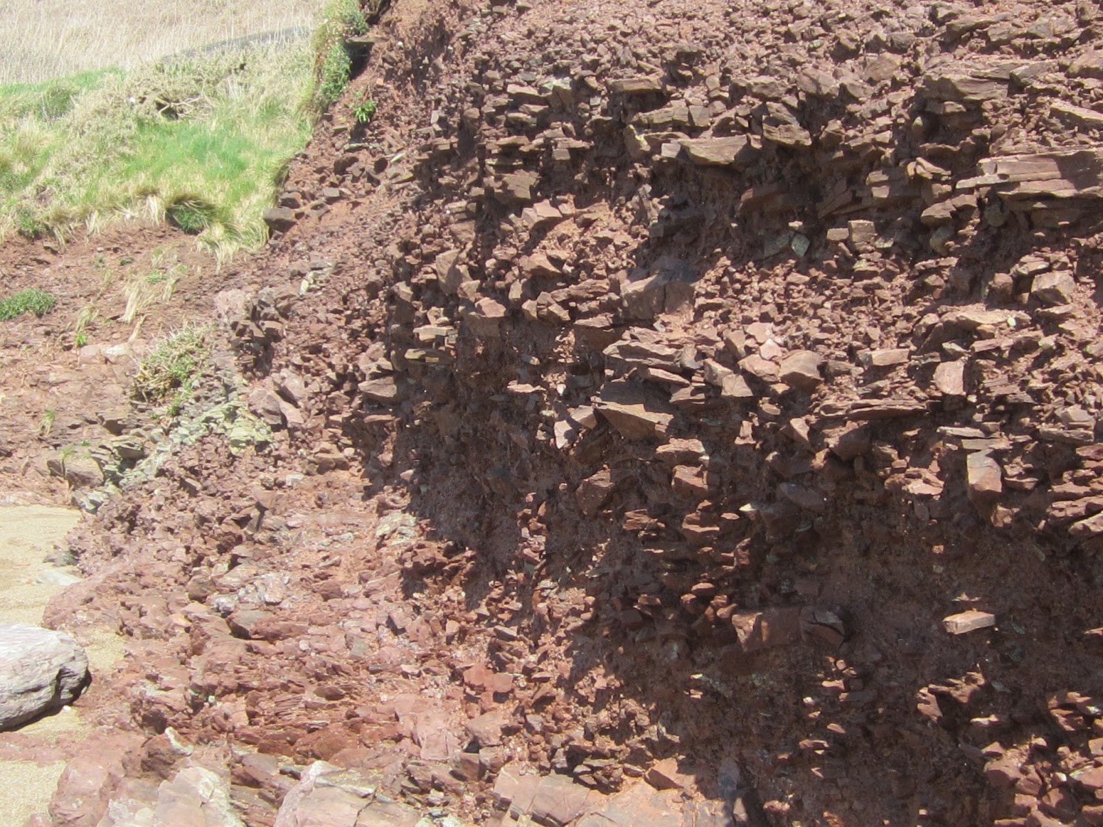
First, the facts.  The geology map shows that the greater part of this area is underlain by Aber-mawr shales and mudstones of Ordovician age, with strips or sills or "microgabbro" (which is another word for dolerite, which is another word for diorite).   But the hill mass appears to me not to be made of sedimentary rocks at all, but of rhyolites and ashes similar to  the rocks to the east, in the Brynberian area.   I think there may even be foliated rhyolites similar to those at Rhosyfelin -- I have some samples, and proper geological identification is needed.  The rocks break up into slabs and flakes, and from the few rock exposures we can look at, there appears to be intense fracturing with multiple intersecting fractures.  Where the dolerite outcrops, to the west of the hill summit, we see occasional slabs and  rock projections up to 2m high, but the ground surface is covered for the most part with a dolerite blockfield, with thousands of weathered and abraded boulders and pillar-shaped stones lying about everywhere.


Foliated rhyolite outcropping in one of the quarry pits to the south of the summit


Part of the dolerite blockfield to the west of the summit.  Bedrock outcrops and loose blocks, some showing signs of glacial abrasion and others broken by frost action

There are scores of quarrying pits, for the most part less than 2m deep and 5m across.  In the most intensely quarried areas, the pits are so close together that the landscape has a "honeycombed" appearance, with intersecting pit edges, and with piles of spoil as well.  The quarries are strung out over a distance of more than 500m, from the edge of the common in the north to near the edge of the  "platform with stones" to the south.  Maybe the quarrying activity has been concentrated on the junction between dolerite to the west and rhyolites and other volcanic rocks to the east?

There are five groups of quarries, and some outliers as well, as shown on the Bing satellite image above.  Quarry 1 has an extent of 40m x 20m; Quarry 2 extends over an area of 30m x 30m; Quarry 3 is 100m x 50m in extent;  Quarry 4 (around the hill summit) is 30m x 30m in extent; and Quarry 5 extends over an area of 150m x 30m.  The total area covered by these quarrying activities is 12,100 square metres.   This is truly quarrying on an industrial scale.

This is what the quarries look like in close-up:


So are the quarries really prehistoric?  I really cannot tell.  Part of me thinks that maybe they have been exploited for rubble for the building of the farm track between Tafarn y Bwlch and the farm called Gernos-fach.  But if that was the case, one would expect more distinct trackways leading from the quarries  and maybe signs of heavy machinery use  -- but the only quarry that shows signs of "farmer exploitation" is quarry number 1, on the northern edge of the common.  So let's keep a question mark about the formation of that one.

But quarry complexes 2-5 are utterly convincing.  How old are they?  Neolithic?  Bronze Age?  Iron Age?  Medieval?  Might they even be related to the presence of a deer park in this area between 1550 and 1750?

And what on earth were the quarries for?  We can consider various options:

1.  Were the quarrymen digging for rhyolite bluestone monoliths for the putative "proto-Stonehenge" on the platform on the south side of the hill?  That's vanishingly unlikely, since the bedrock is flaky and heavily fractured, and does not break up into coherent large slabs or pillars.  Not one of the standing stones or cromlechs in this area is made of flaky rhyolite, let alone Ordovician shales or mudstones -- the stone of choice ALWAYS appears to have been dolerite, if it was available.  And here it was available, in great abundance.

2.  Were they hunting for a rock type suitable for axe manufacture?  That's a possibility, but the rock fragments visible at the surface today do not seem well suited since they are too flaky and do not fracture conchoidally.

3.  Were they digging for disposable scrapers and cutting tools?  Again, possible -- but could quarrying on this scale really have been undertaken for so mundane a purpose?

4.  Might the diggers have been following a quartz vein and digging out white quartz for ornamental use as at Newgrange?    Possible -- there are some rather spectacular quartz boulders in the area, including some projecting through the turf in the dolerite blockfield.

5.  Might the pits have been dug in the Bronze Age in the hunt for mineral ores -- copper or tin, for example?     Possible, but the diggers would probably not have found very much, since this area is not renowned for its rich mineral pickings.

The jury is still out on all of this -- all suggestions welcome!  In the meantime, here are a few photos of what the pits and cuts look like on the ground:


PS.  Another possibility comes to mind:

6.  Might the diggers simply have been taking slabs of rock for building and / or roofing purposes?  Did Bronze Age and Iron Age people use manageable slabs on the roofs of their structures to keep the weather out?  Much more solid timbers would have been used to support the extra weight of slate or shale slabs, as compared with the structure needed to support thatch, but the extra investment in time and effort might well have been deemed worthwhile?


Sunday 29 April 2018

Waun Mawn and Cnwc yr Hydd -- the mystery deepens


Today I have been up on the mountain, and am more and more convinced that there is something important waiting to be discovered in the area to the north of Tafarn y Bwlch  -- around grid ref SN 083345.  This is where MPP and his colleagues will be digging next September, looking for proto-Stonehenge and a giant stone circle.  But I think those matters are of minor significance compared with the other things waiting to be explored on the common.  And the obsession with Stonehenge is unfortunate to say the least, given that the prehistoric features in this area are quite important enough in their own right  as the local archaeologists seek to work out what was going on in the Neolithic and the Bronze Age.

Forgive the purple prose (it's catching!) but I think there is a veritable treasure trove up there.

I have made a number of posts before.  For the record, they are here:

https://brian-mountainman.blogspot.co.uk/2018/04/waun-mawn-and-curse-of-stonehenge.html

https://brian-mountainman.blogspot.co.uk/2018/04/waun-mawn-and-that-awkward-slope.html

Having "looked at the "awkward slope" again today, I've changed my mind and now think that the slope is not a great problem.  If there was a ring of stones there on the outer edge of the "platform" to the south of the hill summit, I think all the stones would have been intervisible if the circle had a diameter of maybe 100m or 110m.  If it had a diameter of 140m, as has been suggested by some, I think the lowest stones on the slope would not have been  visible from the highest ones, and so it would not have made any sense.  Also, if there really was a big circle here, why were the four known stones (one standing and three recumbent) not set further to the north, where there is plenty of room, thereby allowing a whole circle to be placed on a flatter area rather than a sloping one?   Lots of questions...... some of which might be answered when the diggers return in September.

https://brian-mountainman.blogspot.co.uk/2011/09/tafarn-y-bwlch-stone-complex-waun-mawn.html

https://brian-mountainman.blogspot.co.uk/2016/08/deer-hunting-on-waun-mawn.html

https://brian-mountainman.blogspot.co.uk/2011/09/feeding-stonehenge-from-preseli.html

https://brian-mountainman.blogspot.co.uk/2012/10/another-hypothesis-bites-dust.html

https://brian-mountainman.blogspot.co.uk/2011/09/dismantled-stone-circle.html

https://brian-mountainman.blogspot.co.uk/2016/08/gernos-fach-ring-cairn.html

https://brian-mountainman.blogspot.co.uk/2011/09/prophecy-fulfilled.html

https://brian-mountainman.blogspot.co.uk/2016/08/breaking-news-researchers-stumble.html

https://brian-mountainman.blogspot.co.uk/2017/09/new-work-at-waun-mawn.html

https://brian-mountainman.blogspot.co.uk/2017/09/new-work-at-waun-mawn.html

https://brian-mountainman.blogspot.co.uk/2011/09/dismantled-stone-circle.html 


And there is a lot now on the record relating to the nearby features on Banc Llwydlos:

https://brian-mountainman.blogspot.co.uk/2015/05/lake-brynberian-further-thoughts.html


This is the key report which gives the regional context:

www.dyfedarchaeology.org.uk/projects/schedulepembroke2011.pdf

There is so much material from this site, following my investigations today, that I'll put it into three further posts,  on the quarries, on standing and recumbent stones, and on other created features.  

Thursday 26 April 2018

Very smart marketing.....

 Spotted on Twitter, last year.  Brilliant marketing -- now why didn't I think of that myself?  It would have been even more brilliant if the edible MPP had been made of Caerphilly Cheese -- but maybe it's too crumbly?

Craig Rhosyfelin is NOT a Neolithic quarry.....


I discovered that some people are not able to get at things on Researchgate, and have received some advice that it is possible to link to PDFs through the normal posts on Blogger.  So let's do an experiment.  I'm trying to get that short paper (which ANTIQUITY refused to publish) linked onto this page............

https://drive.google.com/file/d/1gN0lDTN1u8nNrFVs29XHko9ZUogcsDIM/view?usp=sharing

I'm trying first with Google Drive.  If anybody would like to try and access this, please let me know how you get on......

Wednesday 25 April 2018

Burl on boulders


I was idly thumbing through Aubrey Burl's "The Stonehenge People" yesterday and came across this interesting statement on page 21:

Referring to the bedrock stone at Chilmark, to the SW of Stonehenge  "..........it is without grain and is simple to cut into blocks, but it was not extracted by Neolithic people who, if they wanted stone, took what there was to hand, glacial erratics or outcrops, neither of which was plentiful on the plain."

Here he is saying that while glacial erratics and convenient rock outcrops were not "plentiful", he did not consider them to be completely absent.  His more interesting point was that  Neolithic people did not appear interested in quarrying for large stones;  so if they were not interested in quarrying close to home, why would they resort to quarrying for monoliths way off to the west, in Pembrokeshire?  That would not make any sense at all, as I have frequently pointed out on this blog..........

Burl also mentions the famous "Welsh bluestone" found in Boles Barrow, and other big stones as welkl, found in Neolithic contexts.  At Boyton 1, a substantial barrow SE of Heytesbury a large boulder "that took the strength of three men to lift out" was found on top of a pile of flints.  We have no ide what rock type it was.  At Arn Hill (Warminster 1) a 1.5 m high standing sarsen was found inside the mound.   There were four big stones forming a chamber in the interior of the Luckington Barrow in Wiltshire.  At Amesbury 4 (now completely destroyed) there was talk of another chamber made of big stones.  The long barrow called Tidcombe and Fosbury 1, in the NE part of Salisbury Plain, had in its interior "three prodigious big stones" standing vertically, with two other smaller stones "of like sort" resting on top of them.  These stones clearly made a burial chamber inside the mound.  Something similar was found at Adam's Grave (Alton 1) on the Marlborough Downs.

Geoffrey Kellaway and Olwen Williams-Thorpe also made the point that while the great majority of the 69 long barrows on Salisbury Plain were simply made of chalk rubble, there are enough examples of features containing big stones to suggest that where big stones were handy, the Neolithic tribesmen on the plain were not averse to using them.  The idea that the Boles Barrow bluestone was an aberration -- carried in from Stonehenge -- just does not hold up.  The most parsimonious explanation as to why it was used is this:  it was used simply because it was there, a good 500 years before Stonehenge was built.

Tuesday 24 April 2018

The Warminster boulders


Thanks to Dave M for alerting us to the presence of three (at least!) rather fine boulders at the Warminster Travelodge.  The pic above is from the web and the two below are from Dave.  The boulder shown below looks as if it might be limestone, but the others are something of a mystery.  Are they local, or are they erratic?

Does anybody know anything about them?  Would somebody like to pop over and take a look?


Monday 23 April 2018

Even more South Pembrokeshire Till


Over the course of three long walks on the South Pembrokeshire coast, I have been finding till all over the place.   At the risk of boring readers, here are some more exposures.  I want them to be recorded for posterity, because South Pembrokeshire is bound to become a focus of activity in the future, as people renew their efforts to define the West Wales Devensian ice edge.  Here we go:


Reddish till made up mostly of shattered limestone fragments with some rounded and faceted erratic pebbles, on the clifftop near Huntsman's Leap.


Rounded erratic cobble in fresh till near Mewsford Point


Till exposure on the clifftop near Bullslaughter Bay


Fine-grained till with mostly small erratic pebbles -- clifftop near Bullslaughter Bay


Till exposed on the clifftop on the western flank of Flimston Fort.  Here again the till is packed with pebbles of quartz -- from ancient Pliocene river gravels or beach deposits?


Another exposure of till near the western edge of Flimston Fort -- on the clifftop.


From an old post:


I have been digging around in some of the old records of the Geological Survey -- from about 1905-1938 -- and have found that the old geologists responsible for the fieldwork in west Wales (Strahan, Cantrill, Dixon, Thomas and Jones) knew all about the glacial deposits scattered across South Pembrokeshire. In their publications they describe many locations where thin till and glacial erratics are to be seen -- including Bullum's Bay on Caldey Island. So I'm not the first to describe this till, by any means. In 1905 EL Dixon wrote of Bullum's Bay: "..... the glacial deposit appears to overlie the raised beach, although the exposure is obscure, and the evidence of superposition is not so conclusive as in Gower." (Summary of Progress for 1905, Mem Geol Surv, p 70). He and his colleagues described glacial deposits at Landshipping, in the inner reaches of Milford Haven; till about 7 ft thick at St Florence; glacial sands and gravels at Bubbleton; gravel and sand at Norchard; sandy loam with erratics at Lamphey; and glacial deposits in many pipes and solution hollows at Catshole Quarry, Pembroke, Sandtop Bay on Caldey, and in other places where Carboniferous Limestone is found. Generally the till in such places is coloured red or pink -- with an obvious association with ORS rocks, and striated sandstone pebbles are also recorded in the deposits, as are pebbles and larger stones of greenstone and felsite.

The Geological Survey maps for the Tenby districts show patches of glacial deposits, as do the maps for the Pembroke and Carmarthen areas.

These are the Memoirs on the Geology of the S Wales Coalfield -- Part XI Haverfordwest - 1914; Part XII Milford - 1916; and Part XIII Pembroke and Tenby - 1921. All are out of print long since, but you will find them in libraries.

The only patch of diamicton or till shown on the latest geological map for  in this large coastal tract is just to the east of the eastern arm of the Bosherston Lily Ponds.

In the memoirs the tills or diamictons of South Pembrokeshire are generally referred to by the old geologists as belonging to the "older Drift" glaciation.   They may be right that many of the inland deposits are very weathered and very old -- but I am convinced that the coastal tills are fresh, and that they must be assumed to be of Late Devensian age.

At the moment, I see no reason to make any great alterations to this map:


Erratic boulders on South Pembrokeshire clifftops


Erratic boulder exposed in an inaccessible position on a vertical clifftop near the Huntsman's Leap, west of St Govan's Head.  This one is maybe a metre long -- heavily abraded and polished and bedded in a rough till made up mostly of broken limestone fragments.  The boulder looks to me ro be igneous, but maybe we will never know.  One day, before long, it will go crashing down to the beach below........


This heavily abraded boulder projects from quite a thick layer of reddish till -- again in an inaccessible position -- on the clifftop of Bullslaughter Bay, about 2 km east of the Green Bridge of Wales.  It looks to me as if it might be rhyolite........

Strange till near Stackpole Head


A couple of days ago, on this very beautiful stretch of coast, on the cliffs of Stackpole Warren, between Mowingward and Raming Hole, I encountered several exposures of rather interesting till.  It's something of a miracle that I am still here to tell the tale, because accessible clifftop exposures are few and far between on the top of these vertical limestone cliffs.  Taking samples is very difficult in most cases, and even getting photos requires rather a good head for heights.  It's a good job I don't suffer from vertigo......

Anyway, to the till.  Here are some pics:


All being well, you can click to enlarge each of the above.  The most striking characteristic is the presence of abundant quartz pebbles and cobbles.  Some of them are broken, but many are intact -- having survived glacial transport from not very far away.  But where did the pebbles come from?  At Flimston, a few kms to the west, there are some claypits in which the famous Flimston Oligocene clays are exposed. Organic remains confirm the age.  They are up to 15 m thick, and appear to have been laid down in lacustrine conditions;  that's interesting in itself, given that the bedrock is highly fractured Carboniferous Limestone.  But associated with the clays (probably above them) are deposits of beautifully rounded quartz pebbles and boulders -- assumed by geologists to be Pliocene river or beach deposits laid down in association with the formation of the coastal platform.  Because virtually all the land hereabouts is within the Castlemartin tank firing range, examination of the ground surface is not encouraged;  but rumour has it that deposits of quartz pebbles are quite widespread.  So the pebbles might have come from the existing land surface to the west of the find site, or from a clifftop area which has subsequently been destroyed by marine erosion.

I have no idea how thick or extensive this till layer might be, but it is certainly more than a metre thick in places.  The matrix is sandy and silty, and the deposit is not cemented, suggesting that it is probably Late Devensian in age.  If you look in detail at the photos, you can see pebbles of all shapes and sizes, and the main rock types represented are limestone (as one would expect), shales and mudstones, sandstones and grits (some of them clearly from Old Red Sandstone outcrops either offshore or near the mouth of Milford Haven), and flints.  I did not have time, on a very quick visit, to hunt for igneous pebbles -- but I would not be surprised if they are present in small numbers.

So the conclusion has to be that the ice topped the cliffs in the Stackpole Warren area.  We should not be surprised by this, given that till (apparently of Late Devensian age)  is also to be seen at Swanlake and on Caldey Island.


I'm intrigued by the similarities between the tills at Swanlake and Stackpole and on Caldey Island with the tills exposed in the low cliffs of the Isles of Scilly.  They look very similar, and they must surely be the same age.........


Coming soon: The Stonehenge Bluestones


Coming soon to a good bookshop near you -- the definitive guide to the great controversy!  A tale told (of course) with great sensitivity and discretion, featuring all the charismatic heroes whom we have grown to love over the years........

New title, new cover, and a great deal of new content, bang up-to-date.

Publication date:  1st June 2018

THE STONEHENGE BLUESTONES

by Brian John

Greencroft Books, 256 pp, 110 illustrations.  Full-colour A5 paperback. 

Cover price £15.00
ISBN 9780905559940

Back cover blurb:

The mysterious bluestones of Stonehenge have caused heated debate for a hundred years, following the discovery that they came from West Wales.   Were they quarried and carried on sledges and rafts all the way to Salisbury Plain by our Neolithic ancestors?  And did the famous monument ever look as immaculate as the archaeologists have imagined it?

Following a meticulous examination of exciting new research from Stonehenge and West Wales, earth scientist Brian John tests a number of fondly-held beliefs to destruction.  He concludes that the bluestones are all glacial erratics, carried eastwards by the Irish Sea Glacier almost half a million years ago and gathered up not far from the monument. 

This book is a detective story with a difference.   It will cause a fundamental reassessment of  “the science of the stones” and enhance our sense of wonder about the forces at work in the natural world. 


Sunday 22 April 2018

The raised beach at Broad Haven South


The northern section of the raised beach platform in Broad Haven South bay.  This section -- in a more sheltered part of the bay -- is much influenced by the fracture patterns in the Cartboniferous Limestone bedrock, so the rock platform is discontinuous, with fragments broken up by deep gullies. 


The southern section of the rock platform, out towards Saddle Point.  Here, because exposure is greater and wave action more concentrated, the platform is more coherent and easy to examine.  The cemented raised beach is so thick and resistant to erosion that in places it roofs over gullies and caverns that appear to have formed more recently.

Apart from Poppit on the Teifi estuary, this is the easiest raised beach exposure to examine, at least in West Wales. The rounded cobbles in the beach are almost all made of locally derived limestone, but there is a lot of broken bedrock debris mixed in, which suggests a cold climate with cliff falls and periglacial slope accumulations in the period immediately following beach formation. In places there are shells in the raised beach gravels and sands, but because everything is cemented these are difficult to extract, let alone identify.   The assumption is that the beach itself probably dates from the last (Ipswichian) interglacial, and that the raised beach rock platform is quite probably older -- maybe it is very old indeed, freshened up over several interglacials when sea-levels seem to have returned to similar high "interglacial" levels.

Here are a few images of the raised beach exposures -- transformed into concrete because of the calcium-rich environment.


What of the stratigraphy?  It's difficult to discern, but in places we can see up to 2m of sandrock (probably blown sand either partly of fully cemented) above the raised beach, with fresh (uncemented) head or slope deposits above, and then with fresh blown sand and sandy loam at the surface.  There appears to be no till or other glaciation-related material at this site.  


There may be three head deposits in this sequence -- one (cemented) mixed in with the raised beach or closely associated with it; another (also cemented) interbedded in the sandrock; and another (uncemented) higher in the sequence, beneath the more modern blown sands and sandy loam.

If this sequence represents the full Devensian cold episode of around 80,000 years, the uppermost head probably represents the late-glacial episode of cold climate incorporating the Older Dryas and Younger Dryas (around 10,000 years ago) and the uppermost blown sands and sandy loam were probably laid down in the Holocene or "post-glacial period".  That would match the situation elsewhere in Wales and in South-west England and the Isles of Scilly.  But where in the sequence does the Late Devesian glacial episode fit?  Somewhere in the "sandrock" period?  I's a bit of a puzzle, but somebody will no doubt sort it out.......

PS.  I found some of my old records from many years ago, and this was the sequence I picked up from some of the exposures in the 1960's:

8.  Sandy loam and blown sand
7. Upper head (uncemented)
6.  (Missing)  Fluvioglacial sands and gravels
5. (Missing)  Till from Dewisland (Devensian) glaciation
4c.  Lower head (cemented)
4b. Cemented sands (sandrock)
4a. Head incorporating raised beach cobbles (cemented)
3.  Cemented raised beach
2.  (Missing) Older glacial deposits -- mostly destroyed
1.  Raised beach platform (complex modifications over several interglacials?)

Note that both the older and younger glacial sequences are missing here.  I was fairly convinced in 1970 that the cemented deposits were all pre-Devensian Glaciation, and that the uncemented deposits are Late Devensian and Holocene in age.


Saturday 21 April 2018

The Bluestone Quarries -- a great gullibility experiment?


Neolithic bluestone quarry?  You must be joking, man.......

Below I have re-posted a blog from eight years ago.  Suddenly, hoaxes and practical jokes are right back in the frame again.  I have been pondering, on this wonderful warm spring morning, and have come to the considered judgment that this whole bluestone quarrying business is actually a rather splendid "gullibility experiment" conducted by a group of smart academics who will, any day now, spill the beans. They will put out a statement saying:

 "Haha!  Fooled you all!  There never was any evidence for these things that we have labelled "Neolithic bluestone quarries"!  We just wanted to see how far we could go with a completely mad idea, inventing evidence, taking nice photos and drawing complex diagrams, placing it all in the learned and popular media, and promoting it through lectures and press releases.  Now we must come clean, and admit that we have just been having fun creating an edifice that has no foundations.  It has cost a lot of money and involved a great deal of effort.  But there has been a serious motive behind all of this -- and it has all been in the cause of science. The lesson is this:  do not believe everything that you are told by senior academics.  Test everything.  Scrutinize everything.  And draw your own conclusions strictly on the basis of what can be observed."

Frightening, isn't it, the extent to which a whole academic community can be swept along by something completely irrational?

======================================


Saturday, 27 March 2010

Two great hoaxes: Piltdown Skull and Bluestone Quarry?


Some see a bluestone quarry -- others don't.
Some see a Missing Link -- others see a hoax.

There was a piece on the telly the other day about the Piltdown Man hoax of 1912. One thing struck me in the commentary -- namely the "fertile ground" which existed in Britain at the time, providing perfect conditions for the hoax to take root, to flourish and eventually (in spite of the reservations of some experts) to become part of mainstream thinking. This is what one web site says about the hoax:

"Perhaps the most famous hoax was Piltdown man. In 1912, at a time when Darwin's evolutionary theory was new, and people were looking for missing links between humans and apes, someone planted two fake skulls which came to be known as Piltdown Man.
The part medieval man, part Orang-utang fossil was found, in the very English village of Piltdown in Sussex. Piltdown man's scientific name, Eoanthropus dawsoni, reflected its finder's name Dawson. To get a flavour of those times, the British Empire was still riding high, and Germany had their Heidelberg man fossil, Britain was desperate for a more important ' missing link' between man and monkey."

The key to this is national pride, and a desire in Britain to demonstrate that whatever important discoveries there were in Germany, Britain had even better ones, showing the world what wonderful ancient civilizations we had here, and what brilliant archaeologists we had to uncover them and to expound new theories of evolution to the world...... OK, petty, nationalistic, xenophobic and even absurd, but that was the world around the time of the First World War. Germany had Neanderthal Man, and now Britain had the "Missing Link" -- even more important.

So what about HH Thomas and the bluestones? Well, I have suspected for some time that Thomas might have been guilty of simplification and selective citation of his samples and his rock identifications, in order to flag up the Carn Meini area as the source of the bluestones. I have also expressed my amazement in earlier posts that he "got away with murder" in that NOBODY seems to have seriously examined his evidence or questioned his wacky idea that the stones had been hauled by tribesmen all the way from Presely to Stonehenge in a totally unique feat of Stone Age long-distance transport. And why did people not scrutinize his theory more closely? Why, because there had been great discoveries about megalithic structures in Germany, and because British archaeologists were desperate to show that in these islands we had even more advanced prehistoric civilisations and even cleverer engineers and technicians.

Sounds absurd? I don't think so -- and a number of other authors have suggested that Thomas's idea was carefully put together around the time of the First World War as part of a national "feel good" strategy, and that the whole nation (and not just the archaeologists) just loved the idea when he announced it, and were disinclined to examine it carefully.

So Thomas became famous, then the bluestones became famous, and the "bluestone transport story" entered the mythology of Britain. It is still trotted out ad infinitum, even though there is even less evidence for it now than there was in 1920. And anybody who dares to question it, or to undermine our cosy assumptions about the extraordinary skills of our Neolithic ancestors, is likely to get short shrift from the archaeology establishment. Look at what happened to poor Geoffrey Kellaway.......

So was the Carn Meini / bluestone quarry / human transport story all a hoax? I think it's a distinct possibility. How much longer will it be before the whole mad idea about human transport is finally consigned to the scrapheap? Not long, I suspect, since the new geology being done by Rob Ixer and colleagues in the Stonehenge area is revealing so many new sources for the stones and fragments at Stonehenge that we are going to have to talk about 20 quarries all over western Britain, rather than one. And that would be to stretch things to a rather extraordinary degree......

All hoaxes have their day, and eventually bite the dust, leaving senior academics looking very foolish.

The Bluestone Enigma


After several reprints, this book has now sold out of stock.  English Heritage snaffled up the last 100 copies not long ago, presumably for the Stonehenge shop........

The book has been very popular, but since it was published ten years ago a great deal has happened, so it needed much rewriting and revision.

The new book will be coming soon.   Watch this space.....

Thursday 19 April 2018

The Devensian ice limit in Pembrokeshire -- update


This is from a recent post:  

I'm still convinced that Devensian ice has affected Caldey Island and has left till there -- and that's just a few miles further east. If ice flowed over Caldey it might have touched Old Castle Head, but because of the military presence there it is out of bounds. I'm now rather convinced that Devensian ice flowed from the west towards the east in this area, and that the great cliff rampart of south Pembrokeshire was an effective barrier which prevented the ice from transgressing inland. The cliffs are for the most part about 35m high, with a further slope of about 10m in the tidal and sub-tidal zone before a gently sloping sea bed with considerable irregularities runs further out into Carmarthen Bay.

There is a fabulous resource for looking at the sea bed here:
http://fishing-app.gpsnauticalcharts.com/i-boating-fishing-web-app/fishing-marine-charts-navigation.html#9.69/51.6675/-4.7369


When the Devensian ice of the Irish Sea Glacier arrived in West Wales there was no sea and no coastline.  Instead, there was a steep rampart or coastal slope where the old cliffs had been in the preceding interglacial -- probably masked at least in part by the rockfalls and accumulated slope deposits built up during a long Early Devensian and Middle Devensian periglacial episode.  This is something I postulated (on the basis of a vast amount of evidence) in the 1960's -- and it is still accepted as valid.

So was this rampart or barrier prominent enough and continuous enough to effectively determine the position of the ice edge?  I am increasingly convinced that the answer is "yes" -- and that the ice, as it moved eastwards into Carmarthen Bay, did not have the strength or thickness to surmount this barrier, except in a very few locations.

Previously I have shown the Devensian ice pushing much further east up Milford Haven and across the western part of the Castlemartin Peninsula, but I am changing my mind on that...............  The reason is that on my recent walks on the S Pembs coast I have been reminded quite forcefully that the most common deposit on the clifftops and in coastal embayments like Manorbier Bay, Freshwater East and Swanlake is head -- a periglacial slope deposit (maybe not always periglacial) up to 4m thick and made up of broken bedrock in a sandy of gravelly matrix.  The thickness of the rockfall / slope deposit depends, as ever, on the characteristics of the local bedrock and the proximity of the old cliffline or bedrock source.  Here are a few examples of this material:

Devensian slope deposits (head) c 2m thick in the face at cliff face at Manorbier -- Old Red Sandstone (Devensian) bedrock.  Above the head, c 20 cms of colluvium or hillwash, and then 75 cms of blown sand and modern soil.


Slope deposits up to 3m thick in Swanlake Bay, close to the sandy beach.  Note pseudo stratification and variations in block size, which migh relate to environmental changes or to changes in bedrock source lithology.  Still to be investigated......


Relatively fine-grained slope deposits exposed in the cliff face on the eastern flank of Freshwater East Bay.  At the top of the sequence sandy loam or colluvium.


This is very interesting -- a nice example of a fossil ice wedge, exposed in the cliff near the beach in Manorbier Bay. The edges of the wedge are clearly demarcated, and the rock fragments that have fallen into it are standing vertically -- that is quite typical.  My interpretation here is that the slope deposits have accumulated during the Devensian cold episode, and that the wedge might have formed during permafrost conditions during the Younger Dryas.

All that having been said, there are certainly exotic stones and pebbles on all of the local beaches, some of them distinctly reminiscent of the volcanics of Western St David's Peninsula and Ramsey Island.  There are also scattered patches of what appears to be relatively fresh till, in locations which currently seem to defy rhyme and reason  -- some day we will no doubt work it out!  Some examples:


Exotic pebbles from the beach at Manorbier.  They are most likely to have come from degraded till deposits in the immediate neighbourhood.


Erratic pebbles incorporated into slope deposits in Swanlake Bay.  Have they come from very old glacial or raised beach deposits or from Devensian till reworked and incorporated into slope deposits since 20,000 yrs BP?


This appears to be undisturbed till, exposed in the cliff face at Swanlake Bay.  Note the abundant small pebbles from multiple locations in the clay-rich matrix.  The greenish cobble  does not appear to carry striations, but it displays abundant pressure fractures, some of which are conchoidal.  That suggests ice transport......

All in all, the evidence is stacking up that this south Pembrokeshire coast  was in some places unaffected by Devensian glacier ice, and in other places the ice touched the present coastline and left traces including coherent till.  The till is very reminiscent of that exposed in the Scilly Islands and on Caldey.  Watch this space.......