THE BOOK
Some of the ideas discussed in this blog are published in my new book called "The Stonehenge Bluestones" -- available by post and through good bookshops everywhere. Bad bookshops might not have it....
To order, click
HERE

Friday 30 September 2022

How ice can eat away a basalt plateau


This is a fabulous image from a new high resolution LIDAR (?) coverage of Iceland:

https://atlas.lmi.is/mapview/?application=DEM

You can zoom in almost everywhere to get amazing imagery of the land surface in great detail.  Above we see a small segment, of the plateau (or what is left of it) around Dyrafjordur, NW Iceland.

What we would have given to have imagery like this when we were working in Iceland in the 1970's.........


BRITICE LGM reconstruction -- did Devensian glacier ice reach Somerset?

 Modelling matched with empirical data suggests that Pembrokeshire and Gower must have been glaciated in the Late Devensian, and that a fast-flowing stream of ice from St Georges Channel affected the outer part of the Bristol Channel.  Some of the model runs showed an ice margin some way beyond the limit shown on this reconstruction.


 The zones designated by the BRITICE team for more detailed studies.  Our area of interest is T4 - Irish Sea West.  It could also have been designated as Celtic Sea East........

Congratulations to the BRITICE-CHRONO team for the vast multi-authored concluding paper (60 pages long) that wraps up the project that has been running for many years, attempting to reconstruct the waxing and waning of the British - Irish ice sheet between 31,000 and 15,000 years ago.  

Here is the essential info:

https://onlinelibrary.wiley.com/doi/epdf/10.1111/bor.12594


Growth and retreat of the last British–Irish Ice Sheet, 31 000 to 15 000 years ago: the BRITICE-CHRONO reconstruction

Chris D. Clark et al
Boreas, 07 September 2022


Abstract

The BRITICE-CHRONO consortium of researchers undertook a dating programme to constrain the timing of advance, maximum extent and retreat of the British–Irish Ice Sheet between 31 000 and 15 000 years before present. The dating campaign across Ireland and Britain and their continental shelves, and across the North Sea included 1500 days of field investigation yielding 18 000 km of marine geophysical data, 377 cores of sea floor sediments, and geomorphological and stratigraphical information at 121 sites on land; generating 690 new geochronometric ages. These findings are reported in 28 publications including synthesis into eight transect reconstructions. Here we build ice sheet-wide reconstructions consistent with these findings and using retreat patterns and dates for the inter-transect areas. Two reconstructions are presented, a wholly empirical version and a version that combines modelling with the new empirical evidence. Palaeoglaciological maps of ice extent, thickness, velocity, and flow geometry at thousand-year timesteps are presented. The maximum ice volume of 1.8 m sea level equivalent occurred at 23 ka. A larger extent than previously defined is found and widespread advance of ice to the continental shelf break is confirmed during the last glacial. Asynchrony occurred in the timing of maximum extent and onset of retreat, ranging from 30 to 22 ka. The tipping point of deglaciation at 22 ka was triggered by ice stream retreat and saddle collapses. Analysis of retreat rates leads us to accept our hypothesis that the marine-influenced sectors collapsed rapidly. First order controls on ice-sheet demise were glacio-isostatic loading triggering retreat of marine sectors, aided by glaciological instabilities and then climate warming finished off the smaller, terrestrial ice sheet. Overprinted on this signal were second order controls arising from variations in trough topographies and with sector-scale ice geometric readjustments arising from dispositions in the geography of the landscape. These second order controls produced a stepped deglaciation. The retreat of the British–Irish Ice Sheet is now the world’s most well-constrained and a valuable data-rich environment for improving ice-sheet modelling.

The paper is too big to deal with in one post, but it is noteworthy for its attempt to draw together vast amounts of data from published reports of fieldwork with new modelling of ice sheet behaviour.  inevitably, there are mismatches between field data and modelled reconstructions, and the authors are honest enough to report anomalies and enigmas where they occur.  Of course, those of us who know particular bits and pieces of the Devensian glaciated area will complain that "they have got it wrong" -- but this is progress, and eventually all will be revealed.

Initially, it is a pity that this study takes a rather strange line running approx from St David's Head to the Isles of Scilly as the eastern edge of the Irish Sea Ice Stream, based on very little field evidence.  There is powerful evidence -- in the published literature -- of Devensian ice affecting all of the western coasts of Pembrokeshire, and for ice wrapping around the Isles of Scilly.  In addition, the proposed ice edge, as I have pointed out many times, defies the rules of ice physics relating to ice flow on unconstrained margins.

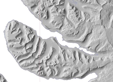
That having been said, as the paper goes on, the authors modify this "starting assumption" and have to accept that Devensian ice in reality pressed much further to the east. This is the map they publish for ice limits as derived from "empirical " observations in the field:


Ice sheet reconstruction based on "empirical date" for 26 ka -- the time of maximum ice extent in the Celtic Sea arena.

Note that the minimum extent is shown as leaving the bulk of Pembrokeshire ice free -- with a rather strange enclave or spur of ice-free land pushing far into the area of relatively thick streaming ice.  I have to take my share of the blame for this, since I have based many posts on this blog to the idea of "ice free South Pembrokeshire".  Those posts were based on the great difficulty we have all had in working out how old the glacial deposits of mid and south Pembrokeshire really are......

But over the past few years I have accumulated so much evidence of fresh glacial deposits along the south Pembrokeshire coast as far east as Caldey Island (and maybe even Ragwen Point) and inland in the Landshipping area and around Narberth - Penblewyn that I now think that the WHOLE of Pembrokeshire was affected by Devensian ice, presumably around 26,000 years ago. 


Interestingly enough, this brings the ice edge into the "optimum" area in the BRITICE empirical reconstruction, and the "maximum position" deemed to be possible from examinations of field evidence extends all the way to the Somerset coast -- so the authors of this vast report are being rather more daring than I have been thus far.........

Then we come to the numerical modelling, based on a vast database and on a multitude of parameters.  This gets even more interesting, since the model pushes a distinct ice stream well into the Bristol Channel:

At last we have streamlines flowing in a direction that makes glaciological sense........

These two modelling maps show that the "South Pembrokeshire ice free enclave" is a somewhat absurd proposition from a glaciological point of view, and that the modellers have found it almost impossible to accommodate in their modelling work.  So it has to be dumped.  It follows that this map is also incorrect, with regard to West Wales:


In the map, north Pembrokeshire is shown as being ice free (following deglaciation) for 26,000 years and mid and south Pembrokeshire for c 130,000 years.  This should be easy enough to check, given the range of dating methods now available to researchers.

Finally here is an interesting extract from the discussion part of the paper:

An egregious mismatch occurred at 26 ka, where the modelled grounding line position of the Irish Sea Ice Stream fell 150 km behind that indicated by the geological evidence (minimum reconstruction, Fig. 6; Scourse et al. 2021). We experimented with various nudges to the model to try and prevent this underrun but they resulted in significant overruns of other parts of the ice sheet, notably with the SW Peninsula of England (Cornwall and Devon) and much of the English Midlands becoming glaciated. The final choice of model run (Fig. 6) is therefore a compromise that mostly fits the wider empirical limits, but underruns in the Celtic Sea. The alternative choice of accepting a model run that reached the shelf edge in the Celtic Sea but also glaciated the SW Peninsula and parts of the English Midlands would have interesting implications for the long-standing hypothesis that some of the stones of Stonehenge may have been transported, at least partway as glacial erratics (e.g. Judd 1902; Scourse 1997; John 2018; Pearson et al. 2019). Although this may indeed be accommodated by earlier more extensive glaciations, we suggest however, that a process, forcing, or feedback is missing in the numerical modelling we present here and that once discovered would enable sufficient ice advance in the Celtic Sea without exceeding ice limits elsewhere. For example, Scourse et al. (2021) suggest that a non-steady oscillation (surge) arose as a release from the build-up of ice behind a topographic constriction in the Irish Sea. We further speculate that the drainage of lakes on the ice stream surface, or floods from subglacial lakes, may have temporarily facilitated faster ice flow and ‘over-extension’ of the ice margin by locally increasing basal lubrication. For the Irish Sea Ice Stream an important challenge remains, to develop new ingredients in process-based numerical modelling so that simulations can reconcile with the geological record.

This is very interesting, since the authors of the paper bring the transport of the Stonehenge bluestones into a debate about DEVENSIAN glaciation.  They also suggest that the Irish Sea Ice Stream might have affected Devon and Cornwall. That is something I have never dared to do, in spite of my reputation -- in certain quarters -- as an unreliable witness!!  The most I have ever dared to suggest is that local ice caps on the SW Peninsula uplands were in contact with ice belonging to the ice stream, somewhere inland of the Bristol Channel coast.

Interesting times.  Watch this space........ and bear in mind that the Somerset Levels embayment is a perfect conduit for ice being pushed in from the west.


Thursday 29 September 2022

Abermawr raised beach, 2014 and 2022


These two photos show the first exposure of the Abermawr raised beach as it was in 2014 (top) and as it is today (bottom).

The exposure is now much more extensive than it was, as a result of cliff retreat and ongoing debris collapse down onto the beach.   Mind you, I have still not managed to examine the "pebble bed" properly, because it would be far too risky for an old codger like me to climb up to it.  I'll leave that to somebody from the younger generation who has a ladder and a rope........

Wednesday 28 September 2022

Brandolini's Law, Bullshit and Archaeological Myth-making


Not so long ago, I got into a bit of a spat on one of the social media platforms relating to the powerful glacial evidence of global warming.  I was making the point that we should "read the glaciers" and link the rates of catastrophic ice melting with man-made climate change.  Not a controversial point, one would have thought -- and there were over 2,000 reads of my post and many "likes" and re-posts.  But I soon noticed that a small number of contributors to the debate were throwing in nonsensical comments that demonstrated (a) their ignorance of the issues involved, and (b) their determination to screw up normal civilised discussion.  In other words, there were trolls at work, and after seeking to engage with them initially, I was warned by another contributor that I should not feed the trolls.  He was quite right.  The discussion was becoming chaotic, aggressive and dominated by those who clearly knew nothing whatsoever about climate change, and I was having to provide considered arguments in order to deal with nonsensical one-liners. So I am out of there!

But one contributor drew attention to Brandolini's Law.  Here are some snippets from Wikipedia:

Brandolini's Law

From Wikipedia, the free encyclopedia

Brandolini's law, also known as the bullshit asymmetry principle, is an internet adage that emphasizes the effort of debunking misinformation, in comparison to the relative ease of creating it in the first place. It states that "The amount of energy needed to refute bullshit is an order of magnitude bigger than that needed to produce it."

Origins

It was publicly formulated the first time in January 2013 by Alberto Brandolini, an Italian programmer. Brandolini stated that he was inspired by reading Daniel Kahneman's "Thinking, Fast and Slow" right before watching an Italian political talk show with former Prime Minister Silvio Berlusconi and journalist Marco Travaglio.

Similar concepts

In Economic Sophisms (1845, 1867), Bastiat expresses an early notion of this law:

We must confess that our adversaries have a marked advantage over us in the discussion. In very few words they can announce a half-truth; and in order to demonstrate that it is incomplete, we are obliged to have recourse to long and dry dissertations.

Other notable thinkers and philosophers have noted similar truths throughout history. In his 1786 Letters on Infidelity, George Horne writes that:

Pertness and ignorance may ask a question in three lines, which it will cost learning and ingenuity thirty pages to answer. When this is done, the same question shall be triumphantly asked again the next year, as if nothing had ever been written upon the subject. And as people in general, for one reason or another, like short objections better than long answers, in this mode of disputation (if it can be styled such) the odds must ever be against us; and we must be content with those for our friends who have honesty and erudition, candor and patience, to study both sides of the question.

Mark Twain is sometimes erroneously quoted as saying that:

It’s easier to fool people than to convince them that they have been fooled.

The yoga scholar-practitioners Mark Singleton and Borayin Larios write that several of their colleagues have "privately" described their "aversion to public debate" with non-scholars because of Brandolini's law.

Burden of proof

When two parties are in a discussion and one makes a claim that the other disputes, the one who makes the claim typically has a burden of proof to justify or substantiate that claim especially when it challenges a perceived status quo. This is also stated in Hitchens's razor, which declares that "what may be asserted without evidence, may be dismissed without evidence." Carl Sagan proposed a related criterion – "extraordinary claims require extraordinary evidence" – which is known as the Sagan standard.

ECREE

The Sagan standard is a neologism abbreviating the aphorism that "extraordinary claims require extraordinary evidence" (ECREE). It is named after science communicator Carl Sagan who used the exact phrase on his television program Cosmos.

The Sagan standard, according to Tressoldi (2011), "is at the heart of the scientific method, and a model for critical thinking, rational thought and skepticism everywhere".

ECREE is related to Occam's razor in the sense that according to such a heuristic, simpler explanations are preferred to more complicated ones. Only in situations where extraordinary evidence exists would an extraordinary claim be the simplest explanation.

======================

I have written a lot on this blog in the past about Occam's Razor, Hitchens's Razor, Carl Sagan, scientific scepticism, the scientific method and the subversive appeal of the ruling hypothesis.

So what has all this got to do with Archaeological Myth-making and the creation of the extraordinary narrative developed by MPP of bluestone quarrying and transport, lost circles, Stonehenge aggrindizement, tribal relationships and power centres?

Quite a lot, actually.  Just think about it.


Monday 26 September 2022

Another whale in a forest


Thanks to Emma Joanne Lee for posting this pic of a whale skeleton in a forest -- on the Osa Peninsula, Costa Rica.  Before you get too excited, apparently it's just about 50m from the shoreline, and it's the skeleton of a juvenile whale killed by commercial whalers, left on the beach to rot and then moved by the locals to a place where it could be preserved as a local curiosity -- and maybe to keep the beach clean.......

The whale found in the submerged forest at Freshwater West some time before 1921 is much more interesting, and much more likely to have come about as a result of natural processes.....

https://brian-mountainman.blogspot.com/2018/09/the-whale-in-forest.html

Sunday 25 September 2022

Abermawr -- the end of the classic exposure?


I was down at Abermawr today, checking on the state of play, and I was shocked to see that the "classic" exposure showing a succession of deposits at shore level -- or along the top edge of the storm-beach -- has been destroyed by a massive series of slumps or sediment flows.  You can see them in this image in the centre of the photo.  

There is no longer any clean and in situ exposure of the Irish Sea till which is accessible.  Across about 30m of the face, where you used to be able to examine it, it's now obliterated by tongues of slumped or flowing detritus -- a mixture of Irish Sea till, sands and gravels, colluvium and blown sand, right down to beach level.  The storm beach has also been lowered and transformed from a regular and well organized feature into something rather chaotic.  

I'm not sure why this has all happened, or when it happened, but these are natural processes at work, dependent upon the water content of the sediment sequence, storminess and  wave dynamics.

I think that the Irish Sea till exposures have been thinning for many years, and I fear that once this slump material is swept away (as it will be) there may not be very much of the wedge left for future generations to study........

Juneau Icefield and glacier disconnections


Click to enlarge.  One of the maps from this study.  A classic example of the art of the geomorphologist. But this is a portrait of a glaciated area undergoing rapid change.

See this:

Topographic controls on ice flow and recession for Juneau Icefield (Alaska/British Columbia). 2022.
by Bethan Davies, Jacob Bendle, Jonathan Carrivick, Robert McNabb, Christopher McNeil, Mauri Pelto, Seth Campbell, Tom Holt, Jeremy Ely, Bradley Markle
Earth Surface Processes and Landforms. Research article. Volume 47, Issue 9
July 2022.  Pages 2357-2390
First published: 13 April 2022
https://doi.org/10.1002/esp.5383

This is a very detailed study in glaciology and glacial geomorphology, containing some of the most beautiful geomorphology maps I have ever seen.......

 https://onlinelibrary.wiley.com/doi/10.1002/esp.5383#.YyYOa_vX_ns.twitter

In my previous article on the catastrophic wastage of glaciers I did not distinguish sufficiently between disconnected glaciers and reconstituted glaciers.  

https://brian-mountainman.blogspot.com/2022/09/lament-for-death-of-glaciers.html

In this study the authors say that reconstitited glaciers (like Boyabreen and Supphellebreen in Norway) are supplied by a constant "feed" of ice fragments falling down a very steep cliff, whereas in many disconnected glaciers (like the ones in this study) the exposed bedrock slope is not steep enough for that to happen. The most dramatic effects are seen where the rockwall is exposed around the ELA (equilibrium line altitude). So the lower part of the glacier is entirely within the ablation zone, and wastes away very rapidly -- with the process enhanced or speeded up by torrents of descending meltwater.

Abstract

Globally, mountain glaciers and ice caps are losing dramatic volumes of ice. The resultant sea-level rise is dominated by contributions from Alaska. Plateau icefields may be especially sensitive to climate change due to the non-linear controls their topography imparts on their response to climate change. However, Alaskan plateau icefields have been subject to little structural glaciological or regional geomorphological assessment, which makes the controls on their present and former mass balance difficult to ascertain.

We inventoried 1050 glaciers and 368 lakes in the Juneau Icefield region for the year 2019. We found that 63 glaciers had disappeared since the 2005 inventory, with a reduction in glacier area of 422 km2 (10.0%). We also present the first structural glaciological and geomorphological map for an entire icefield in Alaska. Glaciological mapping of >20 800 features included crevasses, debris cover, foliation, ogives, medial moraines and, importantly, areas of glacier fragmentation, where glaciers either separated from tributaries via lateral recession (n = 59), or disconnected within areas of former icefalls (n = 281). Geomorphological mapping of >10 200 landforms included glacial moraines, glacial lakes, trimlines, flutes and cirques. These landforms were generated by a temperate icefield during the Little Ice Age (LIA) neoglaciation. These data demonstrate that the present-day outlet glaciers, which have a similar thermal and ice-flow regime, have undergone largely continuous recession since the LIA. Importantly, disconnections occurring within glaciers can separate accumulation and ablation zones, increasing rates of glacier mass loss. We show that glacier disconnections are widespread across the icefield and should be critically taken into consideration when icefield vulnerability to climate change is considered.

Since 2005 the ice-covered area has reduced by 422 km2, and 63 glaciers have disappeared from this study area alone.  In some cases the surface lowering on disconnected glaciers, below the rockwall exposures, was as high as 4m per annum.

Not good news......


Saturday 24 September 2022

Icefall drone footage -- Boyabreen, Norway


This icefall has been vastly reduced in size as the glacier has diminished.  If you look carefully at the ice in some of the crevasses, it is clearly banded or layered -- these are annual accumulation layers, but they are nowadays not very thick, and the dark bands are the summer melting surfaces, very dirty indeed.  This means that in warm weather every summer there is a lot of windblown material about, which reduces albedo, darkens the snow surface and thence increases the rate of melting.  Another sign of a glacier in serious decay -- in spite of all the spectacular crevasse features captured in this drone footage......

Thursday 22 September 2022

Greenland melting rates


 https://eng.geus.dk/about/news/news-archive/2022/june/peripheral-glaciers-

This is a very interesting short article, well worth reading -- giving us in a measured and informed fashion the lowdown on the smaller glaciers of Greenland -- ie those not associated with or connected to the ice sheet.  The news is not good........


This is a map from a previous publication, around 2011, which shows how ice surface elevations are changing.  Note the reductions in ice surface elevations by up to 40 cm per year near the coast, especially in SW Greenland, and the very dramatic melting all the way up the east coast.  In contrast, the ice surface elevation is increasing by up to 20 cm per year in the ice sheet interior.  That's because warm moist air is extenting further in towards the centre of the ice sheet, leading to increased precipitation and ice surface rise.  Overall, the result of these changes (which are ongoing) is an increased ice surface gradient on all the edges of the ice sheet.  That enhances the ice discharge rate, and this is enhanced even further by the huge volumes of meltwater now penetrating down to the glacier bed, increasing bed lubrication and facilitating bed slip and deformation.  All the glaciers are speeding up.... and the ice sheet volume is diminishing fast.

Wednesday 21 September 2022

The beauty of ice caps


Ice caps are endlessly fascinating because they give us, within relatively restricted areas, all of the essential features of the glacier system. 

These are two of my favourite photos from East Greenland, showing the  "ice cap belt" on the seaward flank of the Greenland ice sheet.  The top image shows what the landscape looks like in the winter, and the lower one was taken during the summer when most of the ephemeral snowcover had been melted off.

More on the death of the glaciers


This is a rather sad post.  The two images above are from East Greenland, not far from Scoresbysund.   

The top photo is from the newest 2022 Bing satellite imagery.  I thought first of all that I was looking at a grainy or low-res image, but no -- the speckling effect which we might refer to as "glacier pox" is all down to the presence of thousands of blue meltwater pools on the glacier surface.  These glaciers, within the past few years, have started melting catastrophically, not just down in the snout area but right up into the accumulation zone or ice catchment areas.  Most of the water finds its way down to the bed via moulins and crevasses, but much of it is just temporarily trapped on the surface, reducing albedo and further increasing melting through a positive feedback mechanism.  Seriously scary.......

The lower image shows what this intensely glaciated landscape looked like at the height of the melting season, up until a few years ago.  Nice clean white glacier ice on the glaciers, heavily crevasses but not overwhelmed by surface meltwater.  But then came the tipping point.......

To make matters even worse, it now rains -- instead of snows -- in the summer right up at the heads of these glaciers and on the ice sheet.

This is completely unprecedented, and all we can do is watch in horror while the politicians (like our new PM) pretend that the CO2 reduction targets are somehow disposable items which can be dumped if it is expedient to so so..........  are they mad, or just stupid?

Tuesday 20 September 2022

Lambert Glacier gallery


Stream-lines -- courtesy Glasser, Hambrey and others.


If you ever wondered about ice flowing as a fluid medium, look no further.  This photo looks as if it might have been taken on a rough beach, with the water from a big wave draining away through gullies and channels.........


Rimington Bluff, Mawson Escarpment. with vertical and overhanging cliffs


I'm strangely fascinated by the Lambert Glacier, which feeds the Amery Ice Shelf in Antarctica. In recent years there has been a great increase in the number of excellent images of the glacier, partly because of a strong emphasis on research through the Australian Antarctic Research Programme.

This is the closest parallel in nature to the Irish Sea Ice Stream -- we have a lot to learn from it.......

Wikipedia: At about 50 miles (80 km) wide, over 250 miles (400 km) long, and about 2,500 m deep, it is the world's largest glacier. It drains 8% of the Antarctic ice sheet to the east and south of the Prince Charles Mountains and flows northward to the Amery Ice Shelf.

Celtic Sea arena ice limits -- again


I have been taking another look at this interesting paper from Hughes et al:

Flow pattern evolution of the last British Ice Sheet 
by Anna L.C. Hughes, Chris D. Clark, Colm J. Jordan
Quaternary Science Reviews
Volume 89, 1 April 2014, Pages 148-168

It's interesting, but illustrates just how much disagreement there still is about ice limits on all flanks of the British and Irish Ice Sheet.  For example, the map above (Fig 4 from the article) is useful in many respects -- particularly with regard to ice movement directions of flowlines -- but it is careless in that it apparently displays ignorance of the evidence of glaciation on the coasts of Devon, Cornwall and Somerset.  It's almost as if the authors were afraid of showing ice affecting the SW coasts of England!  Also, the maximum ice edge (shown here as being located to the west of the Isles of Scilly) is now known to be very inaccurate, since the work of the BRITICE team has pushed the LGM limit right out to the shelf edge.  It is quite possible that in earlier glacial episodes the southernmost edge of the Irish Sea Ice Stream was in a similar position or maybe even further to the south, as a calving ice front.

Also, I'm mystified by Fig 4 in the same article, which has an even stranger LGM ice edge shown for the eastern part of the Celtic Sea and the outer part of the Bristol Channel.  The map shows the bulk of Pembrokeshire and Gower as being ice-free, with an ice edge some way off the western coasts of Pembrokeshire.  The map is based on an article by Clark et al, 2012, but really that is rather careless, since the LGM glaciation of western Pembrokeshire and Gower has been known about for more than half a century, with the evidence widely accepted across the specialist literature.  Somebody has not been paying attention.......


Retreat pattern map for the Late Devensian -- after Clark et al, 2012.


Monday 19 September 2022

Could the Irish Sea Glacier have reached Salisbury Plain?

Two of the Boulton - Hagdorn models for the LGM maximum.  These are obviously very simplified or generalised, and the date is all wrong, but the BRITICE team has shown that the ice extended further to the SW than the model predicted -- so in some respects these models are conservative.


As one would expect, I keep this matter under constant review, and I have been looking again at one of the classic papers, by Geoff Boulton and Magnus Hagdorn, which attempted to model the LGM history of the British and Irish ice sheet.

Geoffrey Boulton, Magnus Hagdorn
Glaciology of the British Isles Ice Sheet during the last glacial cycle: form, flow, streams and lobes
Quaternary Science Reviews 25 (2006), pp 3359–3390.

A lot has happened since 2006, including more sophisticated modelling work by Henry Patton and others (already discussed on this blog), the vast research programme of the BRITICE team and an increased awareness of the role of soft sediments and a fluid bed (in the Celtic Sea arena in particular) in influencing both ice stream velocity and ice surface gradient.  It's now pretty widely accepted that the Irish Sea Ice Stream between St Georges Channel and the shelf edge had a maximum velocity of around 1 km per year and an exceptionally low surface gradient.


These models show predicted ice surface elevation and horizontal velocity on the glacier bed.

The trouble with these models --as indeed with all the others that followed within the last decade or so -- is that they are MODELS that require massive manipulations to take account of local topographt and ground surface conditions -- not to mention rock type variations, terrain roughness, and climatic and glaciological variability.  Eventually the models have to be built on so many variables that they become unworkable, requiring enormous computing power.  And when you add "ground truthing" it starts to get really confusing, because research workers still do not agree about the precise positioning of the ice edge at the maximum or at any other stage in the life of the ice sheet.  But that's science for you......... and eventually it WILL all get sorted out.


For comparison, here are two of the very old models showing approx ice surface contours and streamlines.  In the south-western segment the ice edge is more than a hundred km away from where it should be, but one thing that is accurate about these old models is the portrayal of ice stream directions perpendicular to the ice edge.  That respect for a basic glaciological principle has been forgotten about by many of the researchers within the past decade, which is why, over and again, they fail to accept that ice MUST have progressed eastwards for some distance up the Bristol Channel, both in the LGM and in earlier glacier episodes.

I'm still very convinced that the scenario during the "Greatest British Glaciation" (at least in the SW) looked something like this:


.... and that the LGM situation was something like this:


Sunday 18 September 2022

Lament for the death of the glaciers


Not so long ago, there was a big glacier here, calving into the lake........


I have been looking at a very interesting paper on the imminent demise of the biggest glacier in Austria, and I was struck by the above photo which shows how the extension of the ablation area higher and higher up the glacier eventually leads to the exposure of the headwall.  Once that happens the supply of ice from the plateau or mountain ice field is shut off, and the death of the glacier becomes a certainty.  Other work from Bethan Davies and her colleagues on the Juneau Icefield in Alaska has shown the same happening there.

Note from the above annotated photo how visible the headwall is, with only a small icefall from the right hand side actually maintaining an ice supply to the upper part of the glacier.   Other old supply routes on the left are now labelled as "disconnections", in which feeder glaciers are now replaced by "regenerated glaciers" -- in which an ice cone below is fed by falling ice fragments coming down from a broken glacier high up on the cliff above.  The regenerated glacier cannot realistically contribute much to the maintenance of the main glacier in its outlet trough.

When I was doing work in Iceland we saw the beginnings of this phenomenon on Kaldalonsjokull, one of the outlet glaciers from the Drangajokull ice cap.  In the 1970s the rock headwall of the trough was beginning to appear as a dark patrch of debris, and we saw this as the beginning of the end for the glacier -- although at that time we had no idea how quickly the rate of melting would accelerate.  Kaldalonsjokull does not even have any small regenerated glaciers to feed it with broken ice debris.


Kaldalon.  This photo was taken in August 2000, showing a glacier that was moderately healthy, with a more or less continuous feed from the Drangajokull ice cap.  But there were signs of the trough head beginning to emerge from the ice.


A recent photo of Kaldalonsjokull in NW Iceland, with the trough head now emerging from the ice, where once there was a continuous stream of ice from the ice cap above.  This is a classic "disconnection".

When working with the staff of the Norwegian Glacier Museum at Fjaerland, I was impressed by the monitoring work they have been doing over a long period on the regenerated glaciers of Boyabreen and Supphellebreen on the flanks of the Jostedalsbre ice cap.  Previously these had been discrete small outlet glaciers with steep gradients, occupying small subsidiary valleys on the flanks of bigger glacial troughs. It was interesting -- and depressing --  to see how over the course of a single human lifetime the gap between the top (or feeder) part of the glacier and the bottom (regeneration cone) was getting wider and wider.


Supphellebreen 1867, taken not many years after the separation of the upper and lower 
segments of the glacier


Supphellebreen in 1993, showing the icefall supplying the ice fragments which accumulated to form the regenerated glacier below.  The base of this strange little glacier was just 60 m above sea level.


All that's left of the glacier today -- just a very small patch of ice, which will be completely gone within a few years.


Boyabreen in 1868, a reasonably healthy ice cap outlet glacier.


Boyabreen in 1993, some years after the glacier split into two halves.  From this point on, the lower glacier became a regenerated glacier, fed entirely by ice fragments cascading down from above.


Boyabreen in 2021.  The regenerated glacier is almost gone..........

Originally, we all thought that these retreating or declining small glaciers were coming back to a state of equilibrium, following the cold snap of the Little Ice Age, during which glaciers all over the northern hemisphere actually advanced for a while. But we were wrong.  There is something much more serious happening here -- and it's called man-induced global warming.

Saturday 17 September 2022

Waun Mawn new references


All quiet on the western front......

Some people have got a bit confused about the two geological articles which confirm no link between Waun Mawn and Stonehenge.  It's a bit confusing because they were released in June into the public domain, although strictly they are not due to be published until October........  Don't ask me what the logic of all that is..........

They are both available via Researchgate, although if you want the full text you may have to request it from the lead author in each case.

---------------------------

Pearce, N.J.G., Bevins, R.E., and Ixer, R.A. 2022. Portable XRF investigation of Stonehenge-- Stone 62 and potential source dolerite outcrops in the Mynydd Preseli, west Wales. Journal of Archaeological Science: Reports 44 (2022), 103525

https://www.researchgate.net/publication/361417309_Portable_XRF_investigation_of_Stonehenge_Stone_62_and_potential_source_dolerite_outcrops_in_the_Mynydd_Preseli_west_Wales

Bevins, R.E., Pearce, N.J.G., Parker Pearson, M., Ixer, R.A., 2022. Identification of the source of dolerites used at the Waun Mawn stone circle in the Mynydd Preseli, west Wales and implications for the proposed link with Stonehenge. Journal of Archaeological Science: Reports 45 (2022) 103556.

https://www.researchgate.net/publication/362119860_Identification_of_the_source_of_dolerites_used_at_the_Waun_Mawn_stone_circle_in_the_Mynydd_Preseli_west_Wales_and_implications_for_the_proposed_link_with_Stonehenge

=========================

My own assessments of the importance of these papers are already on this blog:


https://brian-mountainman.blogspot.com/2022/06/sh62-much-ado-about-nothing-very-much.html


Stone 62 at Stonehenge -- courtesy Simon Banton.