THE BOOK
Some of the ideas discussed in this blog are published in my new book called "The Stonehenge Bluestones" -- available by post and through good bookshops everywhere. Bad bookshops might not have it....
To order, click
HERE

Thursday 29 February 2024

The Battle of the Stonehenge Bluestones -- evening lecture


Fishguard & Goodwick Our History / Abergwaun ac Wdig Ein Hanes
https://theatrgwaun.com/production/ein-hanes-the-battle-of-the-stonehenge-bluestones/

Our March talk - booking open now. This should be one to interest everybody -and the speaker is our renowned local geomorphologist Brian John who himself lives on the slopes of the Mynydd Preseli.

"Over the last century there has been a vigorous debate involving earth scientists and archaeologists over the Stonehenge bluestones and their link with Pembrokeshire. How did they get from here to there?
In 1923, geologist H. H. Thomas claimed that glacial transport was impossible and that the bluestone monoliths must have been carried by humans. That modern myth has persisted to this day, and elaborated to include “bluestone quarries” and a “lost stone circle”. But does the evidence support the story? "

----------------------------

A few weeks ago the committee of the local history group at Theatr Gwaun in Fishguard invited me to give a talk on the dispute surrounding the bluestones -- and of course I agreed.   So here we go -- date fixed as 13th March, starting at 6 pm. I shall seek to be as balanced as possible in my presentation, and hope we will have a jolly discussion afterwards.

Everybody welcome!

Stonehenge photo used on the poster -- courtesy Simon Banton and the Stones of Stonehenge web site.

Archaeologists are their own worst enemies


Tony has drawn my attention to a strange article in the current edition of British Archaeology. It's an opinion piece on p 66, written by Dr Chloe Duckworth. It is entitled "Woke archaeology and culture wars" and while I am not entirely sure what its main point is, there is much in it that I agree with. She criticises equalities minister Kemi Badenoch for interfering in academia and for suggesting that a research article on the relationship between ethnicity and susceptibility to the bubonic plague was "sensationalist research" coming from "woke archaeology". Well, Badenoch is a very silly person who should keep her nose out of things she does not understand. She and her pet parliamentary rottweilers should know better than to interfere in the academic peer review and publication process. And to use the word "woke" as a term of abuse is calculated to appeal to the nasty people who lurk in the shadows at the far right of the political spectrum. In my experience, the great majority of academics of my acquaintance, across all disciplines, have liberal or social democratic tendencies and are rather good at empathising with those in society who are less well off than they are themselves. If that makes them "woke" that's fine by me. But it is a horrible and disgusting word that smacks of complacency, arrogance and intolerance, and I have an instant mistrust of anybody who uses it. So yes, go for it, Chloe, and flag up the general nastiness of Bedenoch and her ilk........ even in a sensitive and refined magazine like British Archaeology........

As for the rest of the article, I'm not so sure. Ostensibly it is about the Stonehenge road tunnel and ponders on whether it is woke (or not) to support it or oppose it. I have no particularly strong view on the matter of the tunnel, but I do think it's important for archaeologists to be respected by those who hold views that are not in tune with their own. And on this matter they are their own worst enemies. For example, members of the archaeology establishment have based many of their arguments against the tunnel on the emotional, spiritual or even mystical value of Stonehenge and its landscape. We have all heard about the "desecration" of the historic landscape -- and that arises, of course, from decades of myth creation. Gordon Barclay and Kenny Brophy are not alone in expressing concern about mythologisation and marketing of the Stonehenge landscape as something more religious than historic. That overblown view of the old ruin and its landscape, and the ground beneath, does not necessarily strike a chord with everybody, and especially with those who may be concerned with traffic safety and journey times!

At the end of the article Chloe seems to be arguing that archaeologists should be trusted by politicians and others because "scientific rigour" is built into their DNA. Yes, many archaeologists are scientifically rigorous in their work. But others are not, and they are the ones who blow their trumpets most loudly.  They may be technically competent, and indeed they use many high-powered tools in their investigative work -- so for them the term "technical rigour" might be more appropriate.  Some of them clearly have no idea what science is, or how it works.  On this blog, over the past 15 years, I have been highly critical of archaeologists who simply ignore inconvenient evidence, refuse to cite peer-reviewed articles that draw conclusions at odds with their own, and who appear more interested in developing exciting narratives than in finding out the truth.  We can blame "post-processualism" if we like, which at its core seems to demonstrate a profound mistrust of, and dislike for, academic or scientific rigour.  One of the leading journals, Antiquity, published from Cambridge University, seems to have abandoned scientific peer review and now routinely publishes papers that are so full of assumptions, speculations and confirmation bias that they should never have been published at all.  

If archaeology wants respect, on the matter of the Stonehenge tunnel or anything else, the academics need to sort out what they believe in and how they behave.

Wednesday 28 February 2024

Glacial Lake Nevern


Section from the definitive BRITICE-CHRONO map of the British Isles

I have done posts before on Glacial Lake Teifi and Glacial Lake Nevern.  The former did, I think, exist at one time -- and the evidence for it is quite strong.  But Lake Nevern? (That's the smaller lake to the west of Lake Teifi, shown in the Nevern Valley to the SE of Newport. Click on the map to enlarge....)  As far as I can see, it is figment of somebody's imagination.  I think it is a hangover from Charlesworth in 1929, based, as far as I can see, on no evidence whatsoever.

I live in the area that was supposedly submerged beneath this splendid lake, but in spite of enthusiastic searching, I have never seen any laminated silts or clays, or any other evidence (such as shorelines) that might encourage me to think of a large water body.  On the map two ice edge positions are marked in 
the Newport area -- and I can see no evidence in support of them either.

There is a big (and very thick) till sheet in the lower valley of the Clydach stream, but the sediments here do not appear to have laminations, and they are best interpreted as lodgement till.

https://brian-mountainman.blogspot.com/2022/02/the-coed-y-pwll-till-sheet.html

There is a moraine, I think, in Cilgwyn, but that is not marked on the BRITICE map. The only features that might be construed as being associated with a large water body are as series of mounds of sands and gravels in the fields near Caersalem Chapel, at altitudes of 107m - 115m. Charlesworth originally proposed that water from this lake spilled over westwards through the Gwaun Channel. The channel has a humped long profile, with the hump at Llanerch, at 133m asl.   If there had been a meltwater lake here, that altitude would have set the water level.  But it is c 20m too high.  So there was no lake.

We talk often enough about myths and fantasies in archaeology.  But they exist in glacial geomorphology too...........

Beyond the Bluestones


Well, this looks interesting, but there is no way I am paying £16 for the privilege of reading it.  When I have something to go on, I will no doubt be tempted to comment..........

Bradley R. Beyond the bluestones: links between distant monuments in Late Neolithic Britain and Ireland. Antiquity. Published online 2024:1-8. 

ABSTRACT

Recent research has considered the relationship between Stonehenge and sites in south-west Wales, raising questions about whether the first monument at Stonehenge copied the form of an earlier stone circle at Waun Mawn and how the relationship between these sites was connected with the transport of bluestones between the different regions. But Stonehenge and Waun Mawn are not the only prehistoric sites in Britain and Ireland that share architectural elements and hint at social connections across vast distances of land and sea. This debate article explains how the questions raised about these Late Neolithic monuments can and should be applied to other monumental complexes to explore this insular phenomenon.

Antiquity , First View , pp. 1 - 8
DOI: https://doi.org/10.15184/aqy.2024.3

Was there a Late Devensian ice-free corridor in Pembrokeshire? Update


Some of the sites cited in the QN paper.


The revised LGM map showing ice streams and directions of flow

I have noticed that the link used on my previous post about this article, about a year ago, does not work any longer.  That is because the QRA website has been redesigned, and because the archive of past issues of the journal has been made open access.  So (I think) the articles from all past issues are now readily available for anybody to view. Here is the correct link to my paper:

 https://www.qra.org.uk/mp-files/qn158_1_late-devensian-ice-free-corridor-in-pembrokshire.pdf/


Citation:
John, B.S. 2023. Was there a Late Devensian ice-free corridor in Pembrokeshire? Quaternary Newsletter 158, pp 5-16.
==================

Abstract
An ice-free enclave or corridor covering most of Pembrokeshire has featured in many of the recent reconstructions of glacial activity in western Britain during the LGM. This appears to be a hangover from the days when the terms “Older Drift” and “Newer Drift” were frequently used in the literature. However, the supposed ice- free corridor is not well supported in published studies, and it causes difficulty for those involved in ice-sheet modelling. With the aid of new field observations from scores of sites across West Wales, it is suggested that there is no convincing evidence in support of the ice-free hypothesis. The regional Quaternary stratigraphy in Central and South Pembrokeshire matches that of North Pembrokeshire and the St Brides Bay coast, and it is suggested that the whole of the peninsula was inundated by the ice of the Irish Sea Ice Stream travelling broadly NW to SE at the time of peak glaciation, around 26,000 years ago.

The paper incorporates a pretty radical re-interpretation of the field evidence from West Wales, and I'm pleased to say I have had many kind comments about it.  Nobody, thus far, has disagreed with any of it.........


Tuesday 27 February 2024

Was Salisbury Plain glaciated?


This is an  interesting "pseudo satellite"image created by Olav Odé, based on research by Kim Cohen and Marc Hijma, representing the situation in western Europe during the Elsterian glacial episode, around 470,000 - 420,000 years ago.  It's on page 38 of the Doggerland book published by Sidestone Press, and freely available for web viewing.

https://www.sidestone.com/books/doggerland-lost-world-under-the-north-sea

Forget about the artistic license employed in the portrayal of the surface morphology of the glaciated area!  The shadowed hilly areas bear no relation to reality or even glaciology.  There are some bits of the map that do not make much sense. But you have to enjoy the great slabs of broken ice shelf shown floating about off the south coast of Cornwall........

But what matters is the overall position of the ice edge, which is remarkably similar to that which Geoff Kellaway proposed many moons ago, and which I also proposed for the Anglian / Elsterian / MIS 12 glacial episode around 450,000 years ago:

https://brian-mountainman.blogspot.com/2022/02/southern-england-where-is-glacial-limit.html


This also coincides with some of the "outlier" models generated by the glaciology group from Aberystwyth University more than a decade ago.

https://brian-mountainman.blogspot.com/2012/08/where-was-somerset-gbg-limit.html

https://brian-mountainman.blogspot.com/2015/03/the-greatest-british-glaciation-gbg.html

On the Cohen / Hijma map we can see that the local ice caps on Exmoor and Dartmoor are incorporated into the "glaciated area"; that glacier ice is shown transgressing the northern coasts of Cornwall, Devon and Somerset; that the Somerset Levels are shown as glaciated; that there is an ice cover over the Mendips and the Cotswolds; and that Salisbury Plain is glaciated. 

Another interesting feature of the map is the portrayal of France as being largely covered by polar desert, with abundant small ice caps over many upland areas including the Massif central.

Yet another interesting feature --  the presence of a very substantial land bridge linking southern England to the continent.  This was important not just as a land bridge used by migrating human beings, but as a feature which must have affected local climate and precipitation patterns.  We must be careful about assuming that SW Britain was an area of temperate maritime climate characterised by relatively warm temperatures and abundant rainfall;  during this glacial episode (and maybe others) this was more likely an area of very cold and dry climate, as no doubt already identified by the new generation of ice sheet computer modellers.

========================

PS.  I hasten to add that when I did my 2022 post about Southern England, I had no knowledge at all of the Dutch work on ice limits that found its way into print at about the same time.......


A million years of Quaternary oscillations

Since I am in the business of heaping praise today, I'm happy to draw attention to a wonderful diagram created by Malou Osendarp, based on research by Kim Cohen and Marc Hijma, showing the main climatic oscillations of the past million years and contriving, at the same time, to show various environmental changes as experienced in Western Europe.  The descriptive text is in Part One of the book.

https://www.sidestone.com/books/doggerland-lost-world-under-the-north-sea

The basic curve shown on the diagram is the oxygen isotope sea level curve which is now widely accepted as more or less correct.  The high points show the interglacials and interstadials and the low points (highlighted with the white colouring) show the polar desert / glacial episodes.  We can also see the switches between deciduous and coniferous forest cover, the periods of open water as experienced by the present coastal areas, and the episodes where there is clear evidence of human occupation.

This diagram deserves to become a classic, and I will no doubt return to it quite soon..........

There is also a very useful graph on pp 212 and 213 of the book, showing the chronology and the technical labels given by researchers to the key environmental phases.


More on Doggerland


This is a nice "popular" article by Emma Tidswell, summarising what is known about Doggerland.  It''s well researched and quite accurate, from what I can see. One interesting thing about it is that it uses information from research in the Netherlands, and reproduces some of the excellent illustrations from Dutch researchers. There is also a section on the Storegga Tsunami.   Recommended reading.


Doggerland approximately 11,000 years ago during the onset of the Holocene Epoch. At this time sea level was rising inexorably. Dark green colouring indicates higher land. The red outlines delineate the present-day coastlines of Great Britain and Europe.

Source: Olav Odé/ National Museum of Antiquities, Leiden, Netherlands

See also the comprehensive study published by Sidestone Press:


This is also by Dutch authors, and is based on a previously published Dutch volume.  There is a foreword by Vince Gaffney.

Once again, all credit to Sidestone Press for allowing free internet access to the whole volume.  They deserve the Gold Medal for services to open access.......


Anglian / Wolstonian ice extent


In another context, I have been having a bit of an argument with a senior academic about whether there is any sort of a consensus in glacial geomorphology circles about an extensive ice cover in the SW part of the British Isles -- and in particular the Celtic Sea.

Well, I'm very confident that there is a consensus, which gets stronger every year -- for example as more papers are published by the members of the BRITICE-CHRONO team.  I have discussed many of their articles on this blog.  

One example is the map reproduced above, and mentioned in an earlier post on this blog:

https://brian-mountainman.blogspot.com/2015/08/prehistory-and-irish-sea.html

We now know that the ice edge during the Devensian glaciation reached the ice shelf edge -- this was not known 24 years ago when the map was drawn.  Earlier glaciations were at least as extensive, and we now also know that the Scilly Isles were at one time submerged beneath glacier ice.  This means that the ice of the Irish Sea Ice Stream on its SE edge must have impinged powerfully on the coasts of Cornwall, Devon and Somerset.

Does anybody now dispute that contention?  If so, let's hear from you, and let's see the colour of your evidence.........

Friday 23 February 2024

The Wren's Egg glacial erratics


Thanks to Corbred Galdus and Northern Antiquarian for drawing attention to the Wren's Egg and Nest, in Galloway, Scotland.  Posted on Facebook -- nice photos!!  But is the stone in the top photo a glacial erratic and are the other two something else?   

There are apparently four boulders here, but I am intrigued that in all of the official documentation only one glacial erratic is mentioned -- namely the one in the top photo.  The boulders are apparently quite small -- less than a metre in diameter.  They are made of granite, and the source is unknown. I have looked at many photos of these stones, and they have the key characteristics of glacial erratics -- rounded off edges, facets and a weathering crust which is peeling off in places. Since we are dealing with granite, I doubt that there are striations -- but I may be wrong.

What intrigues me here is that boulders 2, 3 and 4 are NOT referred to as erratics, presumably because they are deemed to be in rather crude and simple stone settings -- ie they have been moved a short distance from where they were found.  There is no logic at all in that.  I suspect that the majority of megalithic monuments in the glaciated parts of the British Isles are made with glacial erratics, moved relatively short distances (ie. metres, rather than kilometres) from the places in which they were discovered.

As pointed out by Olwen Williams-Thorpe and her colleagues many years ago, the most powerful factor in the determination of location for standing stones and burial chambers was probably the ready availability of stone -- and I agree with them.

 https://www.historicenvironment.scot/archives-and-research/publications/publication/?publicationId=015d347c-65bd-4955-a456-a6cc009cd744

https://darkgalloway.wordpress.com/

Thanks to Tony for drawing my attention to this topic.

On the significance of bluestones


Three professional geologists pondering on the significance of a bluestone erratic at the
 first International Geological Congress.

Tuesday 20 February 2024

7,000 reads, and counting........


I noticed today that this article on Waun Mawn has now had over 7,000 reads.  I don't know who all these readers are, or where they come from, but it does mean that there are now many people out there in the big wide world who may or may not agree with me, but who are all fully aware that there is a major dispute going on about "Proto Stonehenge" and the "Lost Giant Circle".   The article is now getting a bit dated, since it was last modified in Sept 2022, to take account of recent publications -- but before long I will bring it up to date.

https://www.researchgate.net/publication/345177590_Waun_Mawn_and_the_search_for_Proto-_Stonehenge

In the context of this increased global awareness, it is all the more surprising that the Daily Express has quite recently done another web article on Waun Mawn, with a reporter who seems blissfully unaware of the fact that most of the contents of the article have already been disavowed by our old friend MPP and assorted colleagues. Nobody with any sort of awareness of the literature believes in the "lost circle" any longer.  So who decided that it was a good idea to publish this nonsensical and out-dated article?  The features editor?  If so, he should be sacked........

Or has there been another press release from the MPP team, arising from nothing in particular apart from the desire to keep the lost circle myth alive for as long as possible?  All very bizarre.........

https://www.express.co.uk/news/uk/1867457/stonehenge-mystery-solved-geologists-megalith-wales-spt


Schuchert Flod, East Greenland


The Schuchert Flod (river or flood in Danish) -- one of the most dramatic meltwater rivers in Greenland. Four different levels of resolution....... 

The Schuchert River originates as the stream carrying the meltwater from the Schuchert Glacier and its tributary glaciers in the northern part of the Staunings Alps. There are ten glaciers feeding into the meltwater river, most of them on the eastern flank of the mountain range. These are genuine alpine glaciers with small catchments -- very different from the glaciers fed from the plateau ice caps in other parts of east Greenland.

Braided rivers like this are hugely impressive -- not least because of the noise that they make. It's a non-stop thundering that drowns out all the other sounds in the Arctic environment. But they are inadequately studied by hydrologists and geomorphologists, partly because of their remote locations and partly because they are dangerous and difficult to work on. They have relatively steep gradients, have high velocities and huge sediment loads in the larger clast sizes, namely boulders and cobbles. The water is also cloudy because of the large loads of sand, silt and clay carried in suspension. The larger clasts tend to be moved over short distances before lodging or sticking, with blockages causing the river water to spill laterally out of one temporary channel and to create other channels. So the channel arrangement that we see today are in constant flux.  They will be different tomorrow, and any attempt to create an accurate channel map is rather futile.......

The concept of equilibrium does not make much sense here, because there are very powerful diurnal and seasonal rhythms in river water velocity and volume. In the winter the Schuchert Flod has no water flow at all, and it is cold and dark. But as daylight (and warmth) returns during the spring thaw it starts to flow as the lowland seasonal snowcover begins to melt. As the "melting front" moves up into the valleys and onto the glaciers, in May and June, the volume of water flow inexorably increases. I suspect that the peak flow month will be July. At that time nearly all of the water in the river will be coming from the "feeder" glaciers in the mountains. Also during July and August the diurnal rhythm becomes more marked, as twilight and then darkness gradually return, with cooler conditions and reduced glacier melting in the early hours of the morning. If you have to cross a braided stream in the Schuchert valley catchment, it's easier to do it at 4 am than it is at 4 pm. By September, on the glaciers, there are a few hours of sub-zero temperatutes on the glaciers every night.

The chaotic spring thaw that happens on the big rivers of Alaska and Arctic Canada, involving the breakup of the river ice and the downriver transport of huge ice blocks which can destroy roads, bridges and houses does not happen in the Schuchert Valley, because the braided stream channels are not deep   enough or wide enough for the creation of thick floating river ice.  However, there can be catastrophic "pulses" of meltwater flowing down braided streams such as the Schuchert Flod because of the collapse upstream of ice dams holding meltwater lakes in ice-front situations such as that of the Roslin Glacier.


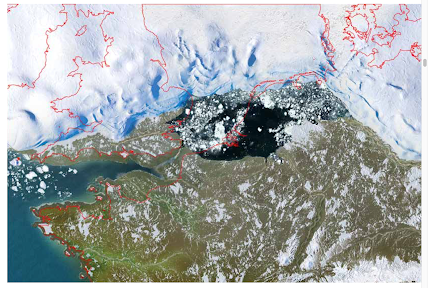
The great loop of moraine and dead ice topography associated with a surge of the Roslin Gletscher, which pushed all the way across the braided river plain. The Schuchert Flod is here squeezed into a single channel, after which it re-assumes its braided pattern downstream. The meltwater lakes are ephemeral; and if one of them bursts out, a short lived catastrophic flood will work its way down the river to the sea. In Iceland this is called a jøkulhlaup, and when one comes along you don't want to be anywhere near it........ 

It's because of this inherent variability in the multiple channels of the braided river that the Schuchert Flod is viewed as essentially uncrossable at the height of the summer season.  You cannot cross -- even with ropes -- where the braided river is at its narrowest, because here the channels are very deep and fast-flowing. But if you try to cross where the braided river is maybe a kilometre wide and where there are multiple channels, you may find that although no single river segment is more than waist deep, you have problems with ropes and stable anchoring points.  In a four-man crossing party the lead man has to be belayed to a support man who stands on a stable (and preferably dry) "island", and he in turn is supported by the third and fourth men on the rope.  Only one man at a time should be in the water, trying to avoid being swept off his feet and also to avoid mobile boulders and cobbles on the river bed.  If you have a 25 kg backpack, then it becomes even more hazardous. There is a practical limit to the amount of rope you can use,  and it can happen that a four-man crossing party can become stranded, when they encounter an uncrossable channel ahead of them and when the channels they have already crossed become deeper because of a raised water level or a change in channel arrangement. In places the Schuchert Flod is 4 km wide, and any attempt to cross it even in the early hours of the morning would be foolhardy in the extreme.

In 1962, while Dave Sugden and I (expedition leaders) were in Kjove Land, one of our expedition members with a four-man party was crossing the Schuchert Flod c. 30 km to the north when he was swept off his feet and carried 100m downstream.  Against all the rules, he was not using a rope, but it's possible that his loaded rucksack provided some buoyancy, and the river spat him out onto a gravel bank from which the others were able to rescue him. He could have been killed.  When Dave and I found out about this incident, we were not best pleased.........


The southernmost section of the Schuchert Flod, where the braided river runs into the tidal mudflats.  The mudflats are a "graveyard" for stranded small icebergs and bergy bits, with larger bergs stranded on the outer edge of the delta


Monday 19 February 2024

Carningli fortified village


Worth sharing.  A great photo by Chris Musson, published on the Coflein (Welsh Government) web site.  It shows the defensive rampart running around the edge of the "village" on the Carningli summit.  The settlement site may have been permanent, but is more likely to have been occupied seasonally.  It's generally thought to have been an Iron Age feature, but there may have been a Bronze Age settlement here as well.........

Thursday 15 February 2024

Bristol Channel seabed features


From the Admiralty seabed maps -- annotations added on the lower version. Look carefully.   Are there 3 distinct moraine belts in Swansea Bay?  I think so.......

Seabed features -- North Pembrokeshire


Thanks to Dan Soper for drawing attention to this resource. Courtesy the Admiralty, they have made available an incredibly detailed seabed "map" which shows up all sorts of fascinating things.  It's a bit clunky, being a Beta version, with intermittent and patchy coverage, and things flip in and out of focus as you zoom in and out -- but it can only get better.

https://seabed.admiralty.co.uk/?x=-597078.23&y=6786158.20&z=11.45 


Here are some initial observations:

1. There are no clear recessional moraines in the southern part of Cardigan Bay, related either to the retreating Irish Sea ice margin or the Welsh ice margin. But the rough sea floor north of Dinas Head and Newport Bay may be made up partly of morainic or fluviuoglacial accumulations.

2. The "mega ripples" or ridges aligned NW-SE to the north of Dinas Head are aligned with the assumed ice direction movement of the Devensian Irish Sea Ice stream. Might they be meltwater features --ie giant eskers? It's a possibility, but care is needed because they may also be ripples related to sediment movements on the bed of the bay, associated with tides and currents.

3.  One's eyes might be playing tricks, but are there two very big channels offshore, around the northern edge of the Pen Caer peninsula?  Might they be meltwater channels, associated with the Gwaun - Jordanston meltwater channel system on land?  It's a distinct possibility.....

4.  There is an enormous feature off the coast of St Devids Head, top left in the upper image.  It seems to have lots of associated small ripples on its edges -- so my guess is that it is a very large sedimentary feature or sand bank linked to tidal and other currents.  Expert opinion needed........

5.  The very rough sea floor off the North Pembrokeshire coast to the west of Pen Caer must coincide with igneous outcrops of dolerite and volcanics including rhyolite.  This offshore belt of outcrops must be seriously considered as a "candidate area" for igneous erratics scattered across Pembrokeshire -- and also, of course, for the Stonehenge bluestones.  

6.  The deep channel between Ramsey Island and the mainland is seen here quite clearly, confirming earlier observations and conclusions.  My money is on this channel being another deep meltwater channel, maybe cut in an earlier glaciation but also used during the ice wastage episode at the end of the LGM.

https://brian-mountainman.blogspot.com/2015/06/new-image-of-ramsey-sound-trench.html


Monday 12 February 2024

The last West Wales glacier


This is Cwm Cerwyn, a classic semi-circular cwm just beneath the highest point in the Preseli uplands -- Foel Cwmcerwyn, which we can see on the skyline.  The hollow is not over-deepened, which means there never was a very active cirque glacier here, but this is a classic situation for the accumulation of snow and the transformation into firn and then ice.  There are traces of till in the sediments adjacent to the stream, just beyond the edge of the shadow on the cirque floor.  

I suspect that a moderately active small glacier developed here and probably survived for a few centuries, around the time of the Younger Dryas / Zone III -- around 10,500 years ago.

I doubt that there was a glacier here in the Little Ice Age, although some small ice masses did develop at this time in the hight mountains of the northern part of the UK.


Satellite image of the cwm


Key features


Saturday 10 February 2024

Bigfoot and Waun Mawn


Some people still perpetrate the myth that there is an academic consensus out there on the matter of the bluestones, but every now and then we encounter a reminder that there are still some people who are capable of thinking for themselves.  This compilation of three 2021 articles published on the "Landscape and Monumentality" blog puts it all rather succinctly:


I have seen this all before, but I had forgotten that the mysterious author of the blog is just as sceptical about the academic worth of "Antiquity" journal (linked to Cambridge University) as I am.......

Quote

"The story of Stonehenge and Waun Mawn is told in the journal Antiquity but if you thought it would be any more scientific than the BBC television program The Lost Stone Circle Revealed, then think again.

Parker Pearson said: “I have been leading projects at Stonehenge since 2003 and this is the culmination of twenty years of research. It’s one of the most important discoveries I’ve ever made.”

This is not a major discovery by any means; it is a supposition painting a romantic image of a people migrating from their homelands bringing their stones, representative of their ancestors, with them in an attempt to solve the mysteries of Stonehenge. But there is one significant element missing: firm evidence.

Finding Bigfoot is more convincing."

Anyway, since 2021 almost all of the speculations that underpinned the elaborate and glamorous Waun Mawn narrative have been whittled away, leaving behind a few bits of wreckage on a windswept Preseli hillside........  as they say, truth will out.


Friday 9 February 2024

How reliable are the pXRF studies of igneous bluestones?


An interesting disagreement has emerged between Rob Ixer and David Nash on the reliability (or otherwise) of the pXRF studies of the igneous bluestone fragments found in the Stonehenge landscape.  The exchange of views comes in a post clearly written by Ixer and posted on Tim Daw's blog:

https://www.sarsen.org/2024/01/what-about-bluestone-pxrf-studies.html

Anyway, in the conclusion to the recent paper by Ciborowski et al (2024) the authors stated:

"Our key message is that studies attempting to use surficial (pXRF) analysis to provenance any excavated artefact must demonstrate that weathering processes following burial did not significantly alter the primary chemical signature of the material before any meaningful provenance interpretations can be made."

"Any future attempts to provenance excavated dolerite fragments at the monument (likely derived from the in situ dressing of megaliths and/or the removal of flakes in more recent history) must consider differences in the weathering regime experienced by the buried fragments, exposed potential outcrops and standing stones. Due to its mineralogical composition, dolerite is more susceptible to chemical weathering than sarsen. Thus, one should expect differences in weathering to be much more significant between buried dolerite fragments exposed to subsoil weathering, and dolerite outcrops and megaliths exposed to differing intensities and durations of subaerial weathering."

Source:  
Local and exotic sources of sarsen debitage at Stonehenge revealed by geochemical provenancing,
T. Jake R. Ciborowski, David J. Nash, Timothy Darvill, Ben Chan, Mike Parker Pearson, Rebecca Pullen, Colin Richards, Hugo Anderson-Whymark,
Journal of Archaeological Science: Reports, Volume 53, 2024, 104406, ISSN 2352-409X,
https://doi.org/10.1016/j.jasrep.2024.104406.(https://www.sciencedirect.com/science/article/pii/S2352409X24000348)

Ixer argues (anonymously, for reasons that are unclear) that their abundant studies of Stonehenge dolerites, rhyolites and other rock types ARE reliable, because they increasingly depend upon both geochemistry and petrology when characterising rock fragments.  That's fair enough, but then he adds that ".......all the pXRF analysis has been on exposed Stonehenge stones comparing to exposed Welsh rocks, so they are like for like comparisons. And the Newall boulder was further analysed to show it was part of a broken monolith from Craig Rhos‐y‐Felin...."   

We'll ignore the somewhat wild speculation about the Newall boulder being  a part of a broken Rhosyfelin monolith and concentrate on the claim that all of the studies so far have been on "exposed" surfaces.  What does the word "exposed" actually mean?   Are buried fragments in a chalky environment exposed in the same way as surfaces exposed to atmospheric weathering?  Clearly they are not, and David Nash clearly agrees with me. You cannot simply assume that you have made "like for like comparisons".   David says, in a comment on the Ixer claim:

"Interesting thoughts but I wouldn’t be quite so confident about work on dolerite orthostats. These would have had fresh faces when quarried, and then slowly weathered at Stonehenge. The surfaces of comparator outcrops in Wales would have been weathering for much longer. This means that the Preseli outcrops are likely to be more altered by weathering than the comparatively fresh orthostats. Plus the weathering environment in Wales will be different to that of Salisbury Plain.  pXRF work needs to bear these differences in mind." (as reported on Tim's blog)

I will disagree with David on the "fresh faces when quarried", since in my view there are no quarries and thus no fresh quarried faces. But there are fresh faces on rockfall debris and on some Stonehenge bluestone monoliths which have been dressed on site -- and especially on the spotted dolerite stones used in the bluestone circle. 

 But I agree with him that there are many different permutations with regard to the fragments and stone surfaces available for examination using pXRF techniques. The technology is still relatively young, and I suspect that many of the results in recent publications will be subject to re-interpretation in the future. Even if all of the bluestone fragments at Stonehenge have come from glacially transported erratics, the surfaces available for examination today will have had vastly different histories. On a single boulder one would expect to find geochemical differences between exposed (upward facing) surfaces and the surfaces buried in the ground. (This is crucial in sampling work for cosmogenic dating, for example.) Some boulders littered in a landscape will be partly covered with vegetation, and others will not. Those on a shady slope will not have the same weathering characteristics as those on a sunny south-facing slope, partly because they may, over time, have been protected by seasonal snow-cover. On broken fragments that are buried, the burial history is important, as is the nature of the sediments in which they are contained.

So I agree with David that there is no room for complacency with regard to the claimed accuracy of the provenancing work on bluestone fragments. It is quite possible that many of the claimed matches between Stonehenge fragments and Pembrokeshire locations are incorrect.  But at least the geologists are facing up to this issue of variable weathering profiles on sample surfaces, and I commend them for that.  I think that in some ways this is the most interesting aspect of the work being undertaken by Ixer, Bevins and their colleagues.

Thursday 8 February 2024

The Life and Death of icebergs


A very big, fresh tabular berg in Scoresby Sund (Photo:  Jenny Ross)


The last remnants of another big tabular berg, off the coast of West Greenland.  This one may be centuries old.  (Photo:  Jenny Ross)

This is an excellent web site, featuring the wonderful photos taken by Jenny Ross, with a very strong environmental message.  Thoroughly recommended:

https://www.lifeonthinice.org/images/greenland-ice-landscapes

Take a look at it!!

Tuesday 6 February 2024

A very weird glacier in North Greenland


I came across this oblique photo in an obscure article about mineral deposits in North Greenland, and I have to say I am very flummoxed by it.  This is a part of JP Koch Fjord, in the far north, on the edge of Peary Land.

It all looks perfectly straightforward as a typical North Greenland landscape of glaciers and plateau ice caps, but what are we to make of the glacier to the right of centre, in the photo?  The cliffs are here up to 1200m high, and the small glacier descending to the fjord just on the front edge of a big fjord glacier seems, quite literally, to be falling off a cliff.  There even seems to be an overhang in the cliffs......  There is no reconstituted glacier here, and somehow or other the glacier falls all the way down to the bottom of the cliff like a petrified waterfall, with a chaotic jumble of smashed ice blocks held in position by the sea ice in the fjord.

The little glacier has no valley of its own.  Does this mean that it is very new?  Or is this just a sign that in this high Arctic environment the ice has no erosive capacity, and simply slides across a permafrost surface and then tumbles over this massive rock cliff?  Or is the ice frozen onto its bed, and moves entirely by internal deformation?

Now that is something I would love to see before I die, but I don't suppose I shall get the chance.  So much to see and so little time.......


Friday 2 February 2024

Løberen -- Greenland's galloping glacier


I found this in an article about Greenland glaciers, in the context of a section on East Greenland.  Løberen is just one of a number of surging glaciers in the Staunings Alps, and their behaviour is still not well understood.  Anyway, the graph shows that the little glacier in question (the dashed line) advanced c 7.5 km in the period 1955-1965, with a peak rate of advance of c 1 km per year.  We worked on the glacier next door -- Oxford Gletscher -- in August 1962, blissfully unaware of what was going on in the next valley a little further up the fjord.  At that time it seems that Løberen reached the sea, so there must have been a calving ice front. 

The graph shows, for comparison, the behaviour of two fairly normal glaciers in West Greenland, and one "pulsing" glacier.


Satellite Image Atlas of Glaciers of the World
GREENLAND
By ANKER WEIDICK
US Geological Survey Professional Paper 1386-C

When glaciers surge, yo9u get5 chaotic patterns on the glacier surface, and after the surge extensive areas of "pitting" or rapid melting because large amounts of ice have been transported to situations far below the firn line where ablation rates are high.  

Anyway, since 1962 the glacier front has retreated far back up the valley to more or less its pre-surge position.

Here are two of the other glaciers in the Staunings Alps area that have surged within living memory.


Bjornbo Glacier in the Schuchert Valley


Oxford Glacier, on the north shore of Nordvestfjord


PS.  You can recognize surges withy a fair degree of certainty in satellite imagery by the strange loops of moraine which disrupt the normal orderly arrangement of moraines that separate parallel streams of ice within the glacier.  Sometimes the loops associated with surging tributary ice streams push right across a glacier and impinge upon the opposite valley wall.......


The LGM ice edge in the Bristol Channel


Two of the maps from Giglio et al, 2022, representing recent thinking, in tune with the BRITICE-CHRONO work.  At the eastern edge of these maps there is a problem..........

 I have been reading an impressive article by Christiana Giglio et al (2022) about the evidence for ice advance and retreat during the late Devensian.  Details:

"Character of advance and retreat of the southwest sector of the British-Irish Ice Sheet during the last glaciation"
Cristiana Giglio et al 
Quaternary Science Reviews 291 (2022) 107655

It's an interesting and worthy contribution to our understanding of what went on in the Celtic Sea arena, with much information coming from studies of sea bed sediments and features off the SE coast of Ireland. The authors agree that the maximum extent of the LGM Irish Sea Ice Stream was right out on the Celtic Sea shelf edge, around 26,000 years ago.  The isochrones show the ice edge retreating at a phenomenal rate, clearing through the St George's Channel within 2,000 years of the maximum extent. Sea floor bedforms and "palaeo channels" seem to make sense almost everywhere, except for the eastern edge of the ice lobe.

Now (not for the first time) I have to have a little gripe, since the outermost eastern ice edge as shown does not make sense.  Nor is it supported by any evidence. For the umpteenth time, ice that is flowing in unconstrained situations does not flow parallel to the ice edge.  It flows perpendicular to it.  Why do people persistently fail to appreciate that point?  Part of the problem is the persistence in the literature of the South Pembrokeshire ice-free enclave or corridor, which we can see on both of the above maps.  Well, following the publication of my 2023 article in Quaternary Newsletter, we can now abandon the idea of an ice-free S Pembs during the LGM:

The ice on the western flank of the Irish Sea Ice Stream (ISIS) did flow parallel to the ice edge (or ice contact zone) because it was constrained and influenced by ice coming from the Irish Ice Cap.  That makes perfect sense.

By removing the considerable South Pembrokeshire constraint, which has caused researchers no end of problems over the years, we can accept that the LGM ice flow at the eastern edge of the ISIS was from the NW towards the SE, and not from the NE towards the SW.  This would be in tune with the alignment of the palaeo-channels mapped off the coast of Cornwall.  It would also fit glaciological theory!  It would make sense for the Isles of Scilly to have been a nunatak at a time of ice cover up to the Cornish coast, with the ice edge perhaps in places a little distance inland.  The other offshore islands (Ramsey, Skokholm, Skomer, Caldey and Lundy) were probably all ice-covered for a few centuries.


Thursday 1 February 2024

Glama, NW Iceland -- after the ice cap


This is an extract from the old topographic map of NW Iceland, showing the Glama Plateau, on which there was, once upon a time, a small thin ice cap. It's clear from the radiating pattern of spectacular outlet glacier troughs (fjords) that this ice cap has come and gone many times, and that it has had prolonged phases of intensive glacierization.


False colour image of the Glama area withy a thin seasonal snow cover.  It shows up rather well the plateau on which the small ice cap existed......

It's been a pleasure to come across the digitized version of Eggert Larusson's doctorate thesis from 1983 -- thanks to the Durham University digitisation programme.  Eggert worked with us in Iceland in 1973-1975, and I supervised him as a research student before I left the university in 1977.  He was able to incorporate a lot of the work done on the Durham University Vestfirdir Project -- and it was great to see so many research strands pulled together in Eggert's big thesis.

http://etheses.dur.ac.uk/7787/

Larusson, Eggert (1983) Aspects of the glacial geomorphology of the Vestfirdir Peninsula of northwest Iceland with particular reference to the Vestur-Isafjarsarsysla area. 
Doctoral thesis, Durham University.

Abstract

The evolution of the landscape of Vestfir6ir, made almost entirely of volcanic rocks, is traced from the lilocene, when the oldest rocks formed, through the Pliocene and Pleistocene. Volcanic activity ceased first in the north western part leaving a basalt plateau with occasional large volcanoes protruding. Fluvial erosion, guided by a westerly dip of the plateau and tectonic lineaments, left a well developed drainage pattern there by the rime volcanic activity ceased in the southeast. The snowline fluctuated widely during the Plio-Pleistocene. Cirque and valley glaciations were very effective in sculpturing the landscape where the preglacial relief was greatest, in the northwest. Ice sheet glaciations affected the whole peninsula and offshore areas with linear erosion dominant in the northwest and areal scouring elsewhere. The glacial geomorphology of Dyrafjorour and northern Arnarfjorour is mapped. The highest marine limit is in the Nupur area, about 110 m, and shorelines and marine limits higher than 70 m are at 7 other localities at least. At least' two stages of glacial readvances are recognized: The Tjaldanes stage occurred when sea level was between 11 and 22 m and is probably of "Younger Dryas" age; later a readvance occurred in the cirques in the area. On the basis of evidence on cirque distribution, cirque elevation, zeolite zonation, distribution of glacial erosional landscapes, glacial history, marine limits, ice cap profiles and shelf moraine a model of maximum glaciations of Vestfir6ir is proposed: The whole of Vestfir6ir and the surrounding shelf areas was completely ice covered with no ice free areas. Such a stage of glaciation, the Latragrunn stage, probably prevailed in the Vestfirdir area during the last glaciation.

Cemented pre-Devensian (?) slope breccia, Traeth Mawr, Newport.


Two exposures of cemented slope deposits at Traeth Mawr, Newport.  The deposits are made of "churned" sharp-edged fragments of local mudstone, suggesting that they may have a periglacial (cold climate) origin.  There does not seem to be any sign of wave action or rounding of the fragments -- and that might suggest that at the time of emplacement sea-level was lower than it is now.  

With reference to my previous post about the Penfro Till Formation and its type localities, I think there is a Penfro Till, but it's not in the places that BGS thinks it's in. If you see what I mean.

One of the places where I think it does exist is Traeth Mawr, Newport, where on a small reef directly in front of the public car park and projecting through the sandy beach there are solidly cemented exposures of till.  Well, there's more -- and on recently exposed bits of the rocky shore platform we can see small exposures of cemented scree or slope breccia.  If my thinking is correct, there may well be a cemented suite of deposits here -- maybe to be confirmed through further observations.

I'm now certain that there is a pre-Devensian till at Black Mixen (Lydstep), Ceibwr, Witches Cauldron and Traeth Mawr -- and I think we can probably add Druidston and Whitesands to that list. At Witches Cauldron and Ceibwr there are also cemented fluvio-glacial sands and gravels.  So we are moving towards a pre-Devensian stratigraphy -- although more work is needed on this.

The west Wales deposits are of course insignificant when compared with the substantial pre-Devensian deposits found in the Midlands and Eastern England -- but it's a start.  And gradually we will begin to put right the terrible errors that stalk the pages of the GWR Wales volume published in 1989 (and, for that matter, the volume relating to SW England......).

Onwards and upwards.