https://www.gov.uk/government/.../SEA6_Archaeology_NCF.pdf
The scope of Strategic Environmental Assessment of Irish Sea Area SEA6 in regard to prehistoric archaeological remains
N C Flemming, Sheets Heath, Sheets Heath Common, Brookwood, Surrey, GU24 OEN.
e-mail: n.flemming@sheetsheath.co.uk
This document was produced as part of the UK Department of Trade and Industry's offshore energy Strategic Environmental Assessment programme. The SEA programme is funded and managed by the DTI and coordinated on their behalf by Geotek Ltd and Hartley Anderson Ltd.
March 2005
Obviously the emphasis is on the Irish Sea itself, and the sea floor features, but there is a great deal of splendidly presented map information, with some maps drawn specifically for this publication. They are worth sharing, with full acknowledgement as to the source.
This is one of the maps, which shows Doggerland in the "late-glacial" -- which I assume means the time at which the last remnant of the Devensian ice sheet occupied the west coast of Scotland. Alternatively the map might represent the situation in the Younger Dryas -- the time of the Loch Lomond Readvance (c 10,800 yrs BP) and the last occasion on which there was a recognisable ice sheet remnant over western Scotland. If that;s the case, the ice sheet remnant should have been located a bit further to the east, leaving the Hebrides largely ice-free.
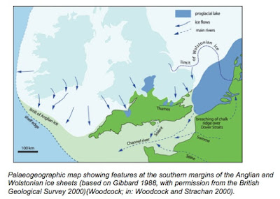
These two maps are also very informative, showing the extents of the Anglian and Devensian ice sheets over Britain and Ireland:
The precise ice limits are not very accurate -- since this map was drawn around ten years ago a lot of papers have been published to redefine the positions of these limits in various parts of the UK and Ireland.
One thing I do like about the Anglian glaciation map is the portrayal of ice movements in the Celtic Sea arena -- the arrows are much more realistic than those shown in some other reconstructions.


No comments:
Post a Comment