THE BOOK
Some of the ideas discussed in this blog are published in my new book called "The Stonehenge Bluestones" -- available by post and through good bookshops everywhere. Bad bookshops might not have it....
To order, click
HERE

Sunday 29 October 2023

Flint erratics at Baggy Point


From Paul Madgett:

Fairly recently a largish "erratic" in the form of a flint nodule came into my possession - see attached article I wrote for the North Devon Archaelogical Society's newsletter, and accompanying images. It is just possible that this might have been glacially transported? - but perhaps more likely represents an abandoned "Stone Age" raw material? 

Extract from the Newsletter:


A PUZZLING OCCURRENCE OF A FLINT NODULE ON BAGGY POINT

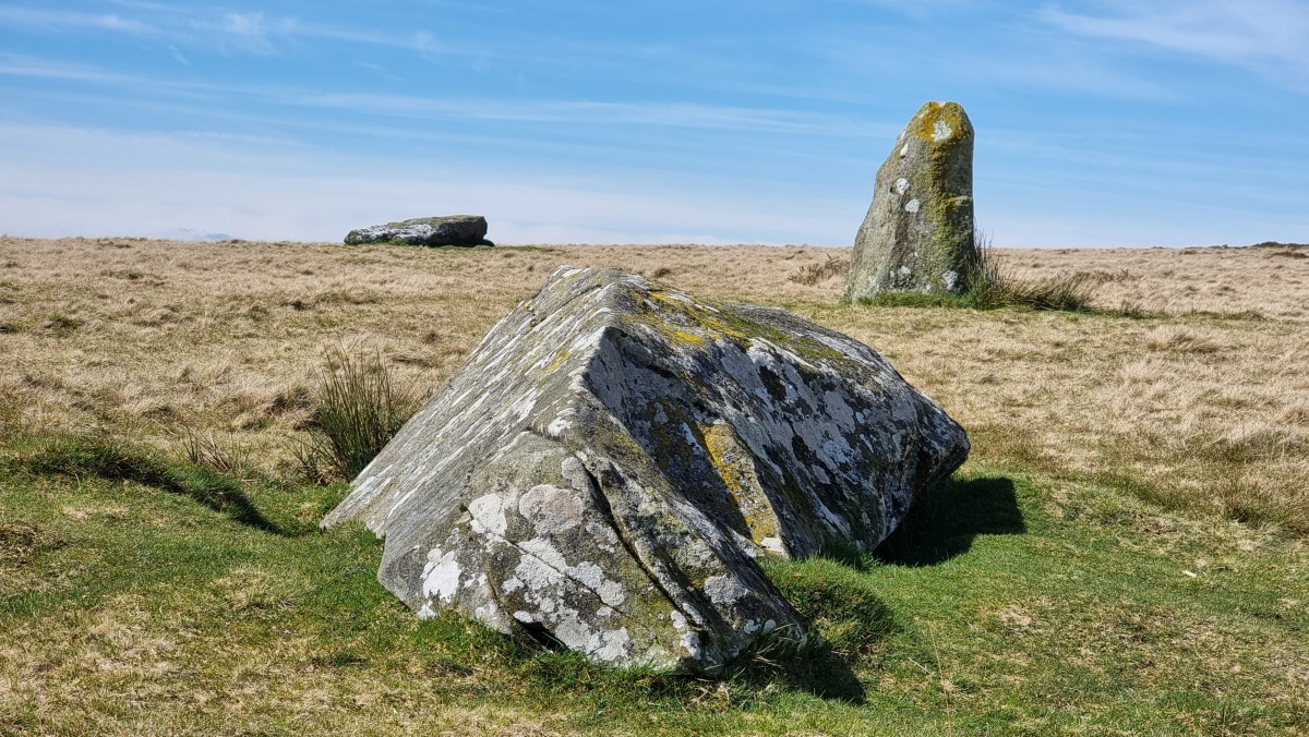
Baggy Point is well-known for scatters of flint flakes and implements, mostly Mesolithic, but with a few from Neolithic and Bronze Ages, even one or two much more recent gun-flints (see “Croyde in my Lifetime”, John Lewis 2009, p.88). Another Croyde resident, David Maddocks, has recently given me a large flint nodule found in the stream bed north of Middleborough Hill. Occasional flint pebbles can be found on Baggy, usually showing signs of flaking, presumed to be from local beaches, but this is the only large nodule I have seen. Irregularly-shaped, size 20x18x14cm, it has a thin white cortex but with several broken surfaces showing the black core. Are these surfaces human-worked, or simply hit by an agricultural implement?

How did it reach Baggy?

Was it humanly transported many thousands of years ago, as much better knapping material than the local beach pebbles? Prehistoric flint-knapping is recorded for Orleigh Court, south of Bideford, using the flint nodules from the Tertiary-aged deposit there; see John Newberry "Inland Flint in Prehistoric Devon" Proc. Devon Archaeological Soc. No.60, 2002. Perhaps some “raw material” was brought to Baggy? But why then abandon such valuable material without obvious use?

Or perhaps it represents much more recent transport, as a “curio”? The Hyde family, who used to own most of Baggy, treated as “garden” the areas near their house, including the valley just upstream from the pond. 

Or maybe a geology student decided the specimen in their rucksack was too heavy, so after a field day visiting various parts of Devon, this nodule was just “dumped”!

Is there a “natural” explanation?

The nearest land occurrence of Chalk containing flints is around Beer in S.E. Devon. Cretaceous sea-levels were far higher than at present, Chalk probably deposited across most of England; the Clay-with-Flints of southern England is considered to be a residual deposit from this, likewise the small Orleigh Court deposit.

Geological transport from either S.E. Devon or Orleigh Court does not seem feasible, but is the latter material just a final residuum from formerly much more extensive spreads, with isolated boulders and cobbles still scattered around the North Devon landscape? A large flint rather similar to this Baggy one was found by NDAS members a few years ago in a valley-bottom context at Holsworthy Farm near Parracombe. Perhaps both had a “residual” origin? Boulders lying around on any sloping ground would have been subjected to solifluction during the Ice Ages, so moved down-slope to valley bottoms (cf. the concentration of Sarsen boulders in Piggle Dene, Marlborough Downs).

There are further potential geological sources offshore: e.g. the Stanley Bank Basin near Lundy – see Cope, J.C.W. 2007. “A new Tertiary basin in North Devon — a progress report”; Geoscience in south-west England, 11, 338-341. This is thought to be of a similar age to, but much larger than the Petrockstow and Bovey Tracey Basins, and being post-Cretaceous is likely to include flints.

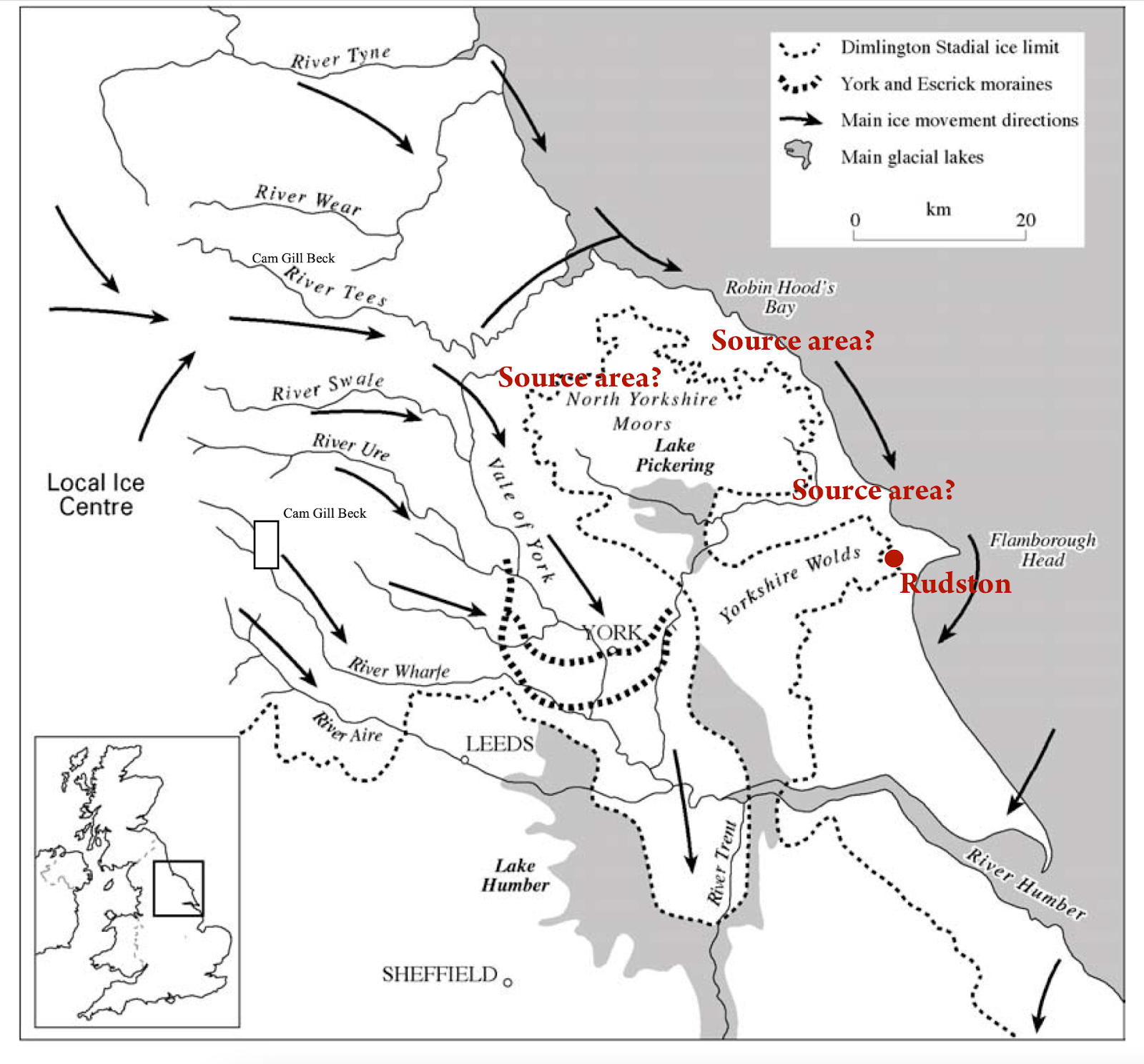
Further offshore, beyond Lundy, the Chalk itself outcrops on the sea-bed, flint nodules could have been eroded from this. Reconstructions of former ice-sheets and their movements indicate that such material could have been glacially-transported to the North Devon coast. Several such non-local / far-travelled “erratic” boulders have been found at high-level on Baggy in recent decades; most easily explained by an over-riding ice-sheet. Could this particular flint nodule have been emplaced by this mechanism? However, this seems less plausible for the Parracombe flint.

Further suggestions?

Paul Madgett, Braunton; 03-05-2020.

Pink tuff erratics from Baggy Point


The pink tuff erratic No 1  found on a wall S of  Croyde Hoe Farm (Photo:  Paul Madgett)

Thanks again to Paul Madgett for enhancing our knowledge of the erratic suite around Baggy Point, Croyde, Devon.  Below are some of his notes, which he has kindly allowed me to reproduce for the record.  Sorry if I have got confused over which erratic is which........ suffice to say that there are several!

You already have info on the "Epidiorite" found back in 1969 by my wife and I during her BSc field-
dragged by the farmer to the edge of the coastal path on N side of Baggy Pt. As you will probably recall from earlier correspondence, I tried a few years ago to re-locate this, without success, despite knowing a fairly precise location for it. My suspicion is that it has become buried under gorse plus ant-hill material.
  See:  
https://brian-mountainman.blogspot.com/2023/10/glacial-traces-near-baggy-point-devon.html

Tuff erratic 2 on top of the wall (Photo:  Paul Madgett)


Photos of tuff erratic No 2, taken by Paul Madgett

A roughly "cubic" tuff erratic (2) spotted in the 1980s on the stone wall by a field-gate by the "top path" on the south side of Baggy Point, near Croyde Hoe Farm, had "disappeared" some years ago. However, in February this year I relocated it, just a short way from that gate. It would appear that someone a few years ago decided to topple it from the wall, and it had become buried in rank vegetation at the side of the path. In August 2022 an illicit barbecue had got out of control so that most of the vegetation on the southern slopes of Baggy, south of that farm-wall, had been completely burnt away - thus fortuitously re-exposing the missing erratic. I moved it back to the base of the wall by the gate, and informed the NT staff responsible for Baggy. Thus I include 3 recent photos of this erratic, to show its current position, size (my size 9 shoe for this!), and close-up of texture. In addition there is another photo taken in 2005, showing its position at that time, on the wall to the left of the gate.

There is (or was, but I haven't been able to relocate it this year) another tuff erratic (1) perched on this wall, around 200m or so to the east of the one referred to above. I initially spotted this around 30+ yrs ago. It has a pinkish colour, evident from the attached image, taken in the late 1990s.

In both cases, their shapes are inconsistent with having spent any time in a wave-dominated environment, hence I conclude that they were emplaced somewhere on Baggy close to their current positions, and presumably by an over-riding ice-sheet.

Patently their current positions are not "natural". My conjecture is that the farmer came across these while cultivating the adjacent field, and added them to his wall - possibly noting their difference from the local slates and sandstones? Mr Bagster, Croyde Hoe farmer before the NT took it over, certainly knew his local rocks and had a large collection of flint artefacts from his fields.


Thursday 26 October 2023

The Bwlch Ungwr Quarry


Meta-mudstone or slate outcropping in the small quarry; this is the resource that was exploited (Courtesy Hugh Thomas, Preseli 360)

Thanks to Hugh for posting this and the images below on his Facebook page -- the images show a small quarry that I have walked past scores of times without noticing.  Grid ref SN138329.  It's rather convincing, and is quite unlike the imaginary Neolithic quarries of Carn Goedog and Craig Rhosyfelin that are much loved by MPP and his digging team. The excavation pits are quite clear, and I suspect that this might have been a short-lived trial dug by some people looking for slate, or else a site exploited by a local farmer or group who were simply looking for roofing or building materials.  Rough flat slabs like these were widely used for stone walls and for building dwellings and farm buildings. 

So I think this is probably related in age and origins  to the string of quarries near Waun Mawn, on the hillside below Cnwc yr Hydd.  I suspect this is not prehistoric, but from historic time -- maybe from the 1700s or 1800s.  Transport from here was mostly downhill, and quite easy for wheeled vehicles, along the route of the Golden Road.

I am still convinced that the only prehistoric quarry in Preseli is the one at Foel Drygarn, which is probably from the Bronze Age and the Iron Age.

More of Hugh's excellent images:

The Carn Goedog channels

The Carn Goedog channels -- a truly spectacular image, courtesy Hugh Thomas and Preseli 360.
 

For many years I have pondered on the significance of the small channels that run along the hillside between Carn Goedog and Carn Alw.  Some of them are too deep to have been cut by the hooves of passing animals during the days of the drovers, and they (or rather, bits and pieces of them) are more likely to have been cut by marginal meltwater streams while the ice of the Devensian glaciation was wasting away on the north flank of Preseli.  So they may be around 25,000 years old, if the latest dating exercise is correct.

I have always wanted to spend a full day here, measuring gradients and examining the topography in detail -- but I have never quite got round to it.......

In Hugh's wonderful photo (above) the channels closest to the drone camera are "normal channels" running straight downslope, but the ones running diagonally across the image are the ones that really interest me.

  Satellite image of the channels /trackways near Carn Goedog.

The channels may well be related to those used by the footpath at 085325 Rhwngyddwyffordd, to the NE of Bwlchgwynt, which are very substantial features:

Satellite image of the channels near the B4329 road


Tuesday 24 October 2023

Pressure gouges or percussion fractures?


Above: the surface of a red sandstone boulder found in till at Penblewyn, near Narberth.  It's a really fascinating one, because it suggests TWO glaciations.  In the first, the boulder was transported, abraded and emplaced somewhere. Could it have come from a coarse fluvial deposit?  Possible -- but there appear to be facets on the boulder which would suggest glacial transport and modification.   Then a weathering crust developed, with the darker coloured mineral veneer.  That suggests a non-glacial interval.  Then the boulder was picked up by ice again, with the surface damage we can see in the photo -- crossing striations and the rough-edged gouges which appear to have been smashed into the boulder surface.  Such features appear all over the world on glaciated rock surfaces -- but nobody seems too sure what to call them.  Percussion fractures?  That's not all that appropriate, because percussion implies a sharp and very powerful impact.  The process here is really one of a hard rock tool being forced down -- slowly and inexorably -- onto or even into a rock surface which is susceptible to damage.  Continuously applied pressure is the thing.   Should we call the features "pressure gouges" ?? Advice gratefully received........

These features are ubiquitous.  See below -- a variety of moulded and striated rock surfaces from around the world, with these rough indentations all over the place, and not particularly well aligned with the striations.  They seem to be concentrated on natural fracture lines.  Sometimes they are fresh -- very rough and jagged -- and elsewhere they may be smoothed off, suggesting modification by some more fluid medium.


Sherlock Holmes and the Mystery of the Stones


 At the moment they are running a "family event" at Stonehenge, as part of the latest marketing push.  The great detective finally sorts it all out -- no doubt with the aid of his infallible ability to see and record minute field details, then followed by powerful deduction.  I would like to be a fly on the wall -- but I wouldn't mind betting that when it comes to Stonehenge Sherlock Holmes will prove to be as gullible as the next man and will simply reinforce the establishment view of everything.........

Bragg and "In our Time" -- too little scrutiny and too much complacency?


Back in March, I gave a glowing review of the "In our Time" programme about megaliths......

https://brian-mountainman.blogspot.com/2023/03/in-our-time-megaliths.html

So I was a bit surprised when I got a very angry message from a long-time follower of my blog.  She had just listened to a recording of the programme on BBC Sounds:

https://www.bbc.co.uk/sounds/play/m001jkzg?partner=uk.co.bbc&origin=share-mobile

She complained bitterly about the lack of scrutiny on the programme, and about the manner in which Sue Greaney was allowed to trot out the narrative about the long-distance haulage of the bluestones without any interruption or questioning from Melvyn Bragg.  I was a bit surprised by that, and discovered that there is indeed a bit about the bluestones in the "extra material" at the end of the programme as it was broadcast.  I don't know whether I missed it originally, or if it has been recently added.

Anyway, my correspondent is quite right.   Listen to the transmission around 41 - 42 minutes. Sue Greaney is there, in full flow, pontificating without any interrogation from the host.  (That is maybe not surprising, since the programme is almost always rather smug or complacent, with "experts" allowed to explain assorted complex things for the enlightenment of the rest of us, gently guided by Melvyn Bragg, with very little disagreement ever coming to the surface.  The assumption always is that the experts are the ones who know the truth, and that they should be allowed to have their say............)

Anyway, Sue Greaney says, with utter certainty and authority, the following:  "We haven't talked a huge amount about moving stones.  One of the interesting aspects of some of these monuments, for example Newgrange in Ireland - the passage tomb -- and the famous monument of Stonehenge, is that the materials that people are building these monuments out of are not just on the doorstep.  They are transporting them over long distances, and in the case of the bluestones at Stonehenge they are transporting them all the way from the Preseli Hills in Pembrokeshire, a journey of 240 km or so, probably over a mixture of land and sea      So the construction of these monuments was not necessarily by using the materials that were immediately to hand.  Some of these monuments, particularly the larger and more complex and spectacular monuments, were also demonstrations of being able to persuade enough people to bring your  stones, sometimes weighing hundreds and hundreds of tonnes, down over -- for example the sarsen stones were moved over a distance of 20 miles or so.  That's a significant undertaking and effort and time, which would have required a huge logistical arrangement in order to supply those people with enough equipment and supply those people with food, and look after their children etc, so the construction of these monuments is a huge event, and part of the importance of these monuments is that process of construction.  It would have been a spectacle, and involving as many people as possible in that, and showing off that you can do that, and that you can persuade that many people to act together communally, to construct these monuments is a significant part of what these monuments are all about....."

As my correspondent says, "This narrative is being repeated time and time again in the most broad reaching media outlets and spoken with such authority to respected personalities, being said enough times that it is clearly accepted as fact.  It's a travesty.  To his credit, Mr Bragg does challenge Julian Thomas saying that it seems not much is actually known, that it seems to stems from inference. The 'inference' has now been so wildly extrapolated, there is no evidence, just this repetition of flawed assertion, a fantasy, that frankly moves archaeology from an empirical science into the normative realm.
The telling of a story about a story about a story is a total decoupling of fact from evidence."

I think I might agree with all of that........ wouldn't it have been nice to hear the word "possibly" or "probably" now and then, or to have heard her say "I think" or "I believe" in the context of her pontifications?  Everything Sue says is portrayed as the truth, with not even a hint of uncertainty or doubt, and with no reference at all to the fact that most of her narrative is speculation, hotly disputed by those of us who are prepared to search on the ground for hard evidence.  This is not science.  This is primary school storytelling.


Thursday 19 October 2023

More and more wonderful........


From the latest Daily Express article on the endless fascination that is Stonehenge -- this time on the Altar Stone "revelations"..........

"An ancient bluestone megalith?"  Psst -- we will tell you a little secret, for the benefit of the Express and Getty Images.  The photo shows a modern monument incorporating various bluestone boulders.  It was built in 1989 by the Cystic Fibrosis Research Trust, at the instigation of Sybil Hughes and with the cooperation of the RAF and the Barony of Cemais.    This is a pic of the plaque:


The stone was moved from near Carn Meini (Carnmenyn) to this site by a Chinook Helicopter, as part of a training exercise.  So there we are then.  

But what the hell?  Who cares about the truth when there is a good story to be told, and good money to be earned from those who are obsessed with the latest wondrous Stonehenge research?


Wednesday 18 October 2023

Altar Stone spectacular -- more nonsense from the BBC


Here we go again -- yet more sloppy journalism from the BBC. This time we can blame BBC Wales and a gullible reporter called James McCarthy for swallowing a dodgy press release about the Altar Stone.  They are about a month later than everybody else in covering this "story", but maybe they just needed something to fill up their local news reporting quota.........

https://www.bbc.co.uk/news/uk-wales-67140221

The story is of course absurd, but the headline is pure tosh.  Aberystwyth University does not say anything about the Altar Stone -- as an institution it is gloriously unconcerned.  What has happened is that a couple of researchers linked to the university have published a paper, with colleagues, which may or may not be reliable.  I wish journalists would be more careful with their attributions.  As ever when this sort of situation arises, the real blame rests with the people who wrote and approved a press release which pretends there is certainty in a published paper which is in fact much more nuanced and hedged about with qualifications.  The paper does NOT say that the Altar Stone is not Welsh -- it says that MAYBE it has come from somewhere else.........

I have dealt with this paper here:

https://brian-mountainman.blogspot.com/2023/09/when-is-bluestone-not-bluestone.html


The Stonehenge Altar Stone was probably not sourced from the Old Red Sandstone of the Anglo-Welsh Basin: Time to broaden our geographic and stratigraphic horizons?
by Richard E. Bevins, Nick J.G. Pearce, Rob A. Ixer, Duncan Pirrie, Sergio Ando, Stephen Hillier, Peter Turner, Matthew Power.
Journal of Archaeological Science: Reports 51 (2023) 104215

https://www.sciencedirect.com/science/article/pii/S2352409X23003905?via%3Dihub

(The paywall has now been removed, which is good news!)

What the authors actually say in the paper is that the Altar Stone was probably not derived from any of the Welsh ORS locations (or from other Devonian and Upper Silurian outcrops) that have been sampled.   Read that sentence again -- the key to everything is sampling density and methodology.  The geologists claim that the Altar Stone samples have higher Ba concentrations than the 58 ORS samples examined, but the Altar Stone samples have concentrations across a vast range (from below 1000 ppm to over 6000 ppm) and some of the ORS samples have Ba concentrations close to the Altar Stone mean of 2750 ppm.  In other words,  the evidence (from the examined samples) that the Altar Stone is "not from Wales" is very thin indeed, and it appears even thinner when one considers that sandstone outcrops from across thousands of sq km of "candidate territory" have not been examined at all by the geologists.........

Because of all of this, I am very surprised that Nick Pearce, one of the authors, has now gone on the record -- in the BBC article --  as saying: "The conclusions (sic) we've drawn from this is that the Altar Stone doesn't come from Wales."    A little more caution might have been a good idea -- and if a suggestion is ever to become something closer to a statement of fact, a great deal more fieldwork is needed in South Wales and the Borders.


Friday 13 October 2023

How do ice sheets grow?


One of the small wasting ice caps of northern Baffin Island.  As it thins, the edges are retreating towards the core.....

As readers of this blog will know,  I have frequently bemoaned the fact that we know a lot about ice sheet collapse and disintegration, but not a lot about the manner in which ice sheets grow, through a process which we might call "blanketing the thickening".  See the following:

https://brian-mountainman.blogspot.com/2023/01/glacierized-landscapes-and-advance-of.html

From this earlier post:

Following a warm (interglacial or interstadial) episode…. the first thing that happens is that temperatures drop, with the mixed deciduous forest replaced by a boreal forest and then by tundra. Then we see the growth of seasonal and then continuous permafrost. That creates conditions where seasonal snow-melt is reduced and eventually eliminated. So where snowfall is substantial (fed by moisture-bearing winds) snowfields develop in the highlands and then in the lowlands, with seasonal melting having less and less of an effect until the whole landscape is covered with snowfields and firn. In favourable locations — on the highest plateaux and in mountainous areas where there are substantial snow-collecting hollows facing north or north-east the firn might thicken substantially until we see the creation of glacier ice. Where there are convenient slopes or discharge routes, glaciers may start to flow and expand, pushing into areas which are otherwise covered with perennial snowfields.

But at what point does streaming ice from far afield start to affect an area like West Wales, where there may be lowlands, upstanding hill masses and plateaux which might support local ice caps? It's clear that this happens very late in the day, towards the back end of a full glacial cycle. The glacierization build-up phase (with extensive snow and ice cover on the landscape) may last for 70,000 years or more, interrupted by short-lived cooling and warming phases or by changes in precipitation and other types of "climatic forcing". But eventually, when the whole land surface has become deeply buried by locally-generated ice, maybe 500m or more in thickness, the big brute from the north begins to dominate -- in this case with the arrival of the Irish Sea Ice Stream - as cold-based ice is replaced by ice that is capable of sliding on its bed. Streaming ice then begins to do serious damage, eroding bedrock, picking up erratics and incorporating pre-existing periglacial and other deposits, and modifying a previously protected landscape in a multitude of different ways. The direction of ice flow is now determined not by the details of local topography but by the surface gradient of the ice stream; in the case of Pembrokeshire ice movement seems to have swung through an arc of maybe 60 degrees, but with a dominant flow from NW towards SE. It appears that the Welsh ice cap did not greatly affect Pembrokeshire, but ice from the Welsh uplands may well have filled Cardigan Bay, creating a constriction that affected Irish Sea ice flow directions. From the BRITICE-CHRONO modelling, Irish Sea ice affects the area for maybe 3,000 years.


This is an interesting short article:

https://www.nbcnews.com/id/wbna22916434

It makes the point that the ice in these small ice caps and ice fields (which were probably initiated in the Neoglacial, after c 7,000 yrs BP) is very thin and cold-based, frozen to its bed, and effectively preserving without disturbance what was there before -- both landforms and sediments. 

In previous posts I have speculated on the lessons that might be learned from Drangajokull and Glamajokull in NW Iceland.  Use the search facility to look them up!

As I have suggested on earlier occasions, Salisbury Plain may well have been submerged beneath an extensive snowfield / icefield for many thousands of years, over and again during the Quaternary.   The enigmatic clay-with-flints may tell us something about what happened, and when........  But if the bluestones at Stonehenge really are glacial erratics, carried in by the ice from the west (and maybe the north as well), exactly how did this moving ice arrive, and what were the basal ice conditions at the time?  It may well be impossible to determine where the ice edge was located, because that would have been impossible if we had looked down at a white surface from a satellite at the time.   More to the point, where was the easternmost extent of MOVING ice capable of carrying extraneous or erratic material?  Work in progress.......


Thursday 12 October 2023

Valley glacier terminal moraines


Another fabulous image from Mike Beauregard. The loops of moraine formed by small valley glaciers are very spectacular -- they are located to the east of Dexterity Fjord in Northern Baffin Island.  The small glaciers have retreated several hundred metres from their advanced positions -- fifty years ago apparently all of these glacier snouts were located at the terminal moraine positions.

https://www.flickr.com/photos/31856336@N03/7048837663/

Here is a Bing satellite image showing the same valley in summer:


In this image, north is at the bottom of the photo.


Raised beach ridges, Southampton Island


This is a gorgeous photo of raised beach ridges on Southampton Island in Arctic Canada.  They are picked out by a thin covering of winter snow.  Photo credit:  Mike Beauregard.

This is one of the areas of highest isostatic recovery rates on planet Earth -- the marine limit on the coasts of Hudson Bay is in places over 300m, and on the Arctic islands occasionally over 200m.......

Wednesday 11 October 2023

6,600 reads for Waun Mawn scrutiny paper


Waun Mawn -- one standing stone and two recumbent.  Photo credit: Horatio

I noticed that the reads for my Waun Mawn paper -- first written in 2021 and revised since then in Sept 2022 -- have now gone over the 6,600 mark.  That's remarkable, and it means that the article is being read by a great number of archaeologists who are less than convinced by the complex narrative woven by MPP on the telly and in other media.

Truth will out, and I will soon do another update to take account of recent research.  Of course, the research team which did the excavation and associated lab analyses for Waun Mawn have already been forced to go on the record and acknowledge that their original speculations and pronouncements were -- shall we say -- premature and indeed foolhardy.  

https://www.researchgate.net/publication/345177590_Waun_Mawn_and_the_search_for_Proto-_Stonehenge

Of course, this article of mine is not peer reviewed in the conventional sense, and might be deemed to be less reliable than it might have been. Fair enough.  On the other hand, as readers of this blog will know, many researchers now have a somewhat jaundiced view of the peer review process, which is often corrupt.  Reviews are often biased and at best subjective, and I have learnt over many years that reviewers can sometimes tell us more about their own belief systems than about the merits or demerits of the document in front of them!  But reviewing is a thankless task, and I sympathise with editors who nowadays find it very difficult indeed to find reviewers ready to tackle even the most significant of submitted articles, let alone the worthy but boring ones that hardly anybody is ever going to read.

I wouldn't mind betting that if my Waun Mawn article had been published in a journal, it would not have had anything like the same number of reads from specialists and non-specialists........ 

The Rudston Monolith


Thanks to Tony for drawing my attention to some recent coverage of the Rudston Monolith in Yorkshire, with the usual guff about human transport..........

This is what Wikipedia says:

The stone is slender, with two large flat faces. It is approximately 5 feet 9 inches (1.75 m) wide and just under 3 feet 3 inches (1 m) thick. The top appears to have broken off the stone. If pointed, the stone would originally have stood about 28 feet (8.5 m). In 1773 the stone was capped in lead; this was later removed, though the stone is currently capped.The weight is estimated at 40 tonnes.The monolith is made of gritstone. The nearest source for the stone (Cayton or Cornelian Bay) is 9.9 miles (16 km) north of the site, although it may have been brought naturally to the site as a glacial erratic. The monument dates to the Late Neolithic or Early Bronze Age.  A possible fossilised dinosaur footprint is said to be on one side of the stone, though a study by English Heritage in 2015 concluded that the claim was unsubstantiated. There is one other smaller stone, of the same type, in the churchyard, which was once situated near the large stone.

I don't know of any detailed provenancing work on the monolith, but it is apparently a gritstone similar to that outcropping in Cayton Bay and Cornelian Bay to the north.  Southward transport of erratics by the flowing ice on the eastern flank of the British and Irish Ice Sheet would be entirely in line with what we know about ice movement directions:


Erratic transport during the Devensian Glaciation is quite possible, but the consensus seems to be that the greatest phase of erratic transport was during the Anglian glacial episode, around 450,000 years ago.  I have seen some speculation that the Rudston Monolith might have come from the Whitby area, or even from the Clevelend Hills.  Quite possible.

Many people have remarked on the slender and delicate shape of the monolith, and have speculated that it cannot possibly have been transported by ice without being broken into smaller blocks. That's a fair point -- and of course there are similarities with some of the slim elongated spotted dolerite bluestone monoliths at Stonehenge. 


Bluestone 69 at Stonehenge.  Very delicate -- and greatly modified by dressing.....

There's a debate to be had on this, and indeed we have discussed glacier entrainment and englacial transport before on this blog.  Extremely long and thin pillars are in some ways anomalies or survivors which should have been broken -- and that is true no matter what the transport mechanisms might have been -- involving either glaciers or human beings.

Wednesday 4 October 2023

LRB podcasts -- what is Stonehenge all about?


There are 4 interesting podcasts made by the London Review of Books -- available on Spotify.  Led by Rosemary Hill.  

The 4 programmes are about the changing views of Stonehenge down through the ages.   I haven't yet listened to all of them......  will report back if I manage to complete the task........

https://open.spotify.com/show/5qp7xVVpV5lavnMcm0zMN1


The raised beach at Westward Ho!


The raised beach near Seafield House, at Westward Ho!  Photo: Paul Berry

I have been looking at some of the very interesting posts on Paul Berry's blog, and came across this one, about Westward Ho!

https://devongeography.wordpress.com/2022/05/25/exploring-the-coastal-geography-of-westward-ho-north-devon/

The photo above struck me immediately as a quite precise match for Abermawr in West Wales, where we also see an ancient high level raised beach overlain by thick slope deposits of "head".  The deposits rest on an old rock platform at c 8 m OD -- about 6 m above the level of thye present tidal platform.  According to Stewart Campbell in the GCR Review volume (1998) the massive raised beach made of boulders and cobbles is up to 3m thick, and in the upper metre or so the raised beach material is frost-shattered, indicating the onset of a period of periglacial climate which culminated in the accumulation of a 1m layer of slope deposits. According to some workers the materials are erratic-free, but Prof Nick Stephens recorded erratics in the overlying "sandy clay with stones" -- and he was convinced that these were derived from glacial deposits in the immediate vicinity.

Another view of the raised beach, from Southwestcoastphotos.com -- taken by David Evans.


This is truly one of the most spectacular photos of a raised beach that I have ever seen!

Quote:

A view from the grassy meadow west of Seafield House (1885) - Westward Ho!.
Beach deposits of mainly Culm sandstone cobbles in a sandy matrix lying on an ancient wave cut platform 
Left high and dry when sea levels fell 125,000 years ago.
Covered with head from the period 10,000 - 100,000 years ago when periglacial conditions -
freeze / thaw cycles caused the rock to fragment into a layer of angular stones and small debris.
Ref: 3209
Date: 27/04/2016
Location: SS 4203 2903


The Westward Ho! Pleistocene sequence, from the GCR Review volume, p 225

For comparison:


The raised beach at Porth Killier, St Agnes, Isles of Scilly, resting on an irregular granite surface and overlain by a thin till (?) with erratics


Remnants of a raised beach (storm beach) resting on a high rock platform at Abermawr in Pembrokeshire

See also:


Tuesday 3 October 2023

Glacial traces near Baggy Point, Devon


The high-level Ramson Cliff epidiorite erratic (photo:  Paul Berry, published on his blog)


Close-up showing the crystalline structure of the epidiorite erratic (photo:  Paul Berry)

Grateful thanks to Paul Madgett and Paul Berry for the following info. 

 I have published some material from PM  before, in 2019, in a post concentrating on the "high level erratic" at Ramson Cliff:

That boulder (altitude c 80m)  is not the only "high-level erratic" on Baggy Point. I know of two others, though smaller - both now on top of the stone wall to the south of Croyde Hoe Farm, and adjacent to the higher footpath/track along the south side of Baggy. Can supply images, if required. Both are tuffs/agglomerates; one a grey almost square block, the other smaller, more irregularly shaped, of a pinkish tinge. Neither were there in the 1970s, and seem to have appeared in the late 1980s or early 1990s. Formerly Croyde Hoe Farm had been mainly arable, and the fields produced regular "crops" of flint tools and waste flakes. In 1969 the farmer, a Mr Bagster, had shown us his collection after we asked permission to walk over his land, and subsequently one of his workmen has allowed me to photograph samples from his personal collection, mostly Mesolithic, but including Neolithic, Bronze Age artefacts, and even a squared-off flint from a flint-lock rifle, all found on Baggy. In the 1990s the new National Trust tenant farmer went over entirely to sheep, so the fields are ploughed only rarely nowadays.

Thus my guess is that the former farmer, knowing of the interest in his land by geologists, and recognising these cobbles / small boulders as "different", having ploughed them up, then placed them in a prominent position for others to see. Neither have the appearance of ex-beach boulders, and I would suggest that they represent the residuum of a former cover of till, now virtually all eroded, most of the boulders once emplaced higher on the coastal landscape now being incorporated into beach deposits, some incorporated in the base of the Raised Beach, as with the Saunton Red Granite (hence any putative glaciation to emplace the boulders needing to be pre-Ipswichian).

I don't have any further details from Paul M, but from the OS maps it looks as if one of these smaller erratics is at around 200 ft (60 m) and the other at around 150 ft (45 m).

Here is another quote, this time from Paul Berry (Oct 27, 2021) in an interesting blog article on the Baggy Point footpath:

About halfway along the north side of Baggy, there is another (smaller) glacial erratic sat right next to the path. It is a 500 kg block of epidiorite of Scottish origin. It is a little difficult to spot, as it is surrounded by gorse, and is slowly disappearing into the surface. Part of the surface has been chipped away, exposing the obvious crystalline structure of igneous rock. It once stood upright in the middle of a nearby pasture field and was used as rubbing post by sheep and cattle. In the early 1970s, the field was ploughed and the rock dislodged and then laid prone. It was then dragged to edge of field where it has been ever since. The erratic can be located at grid reference SS 4356 4070.

Paul B also says:
Other small erratics (tuffs/agglomerates) have been ploughed up nearby and incorporated into the stone wall by the higher path, but they are tough to spot under the dense cover of grey lichen. One is a grey almost square block, another smaller, more irregular shape of pinkish tinge.

https://devongeography.wordpress.com/2021/10/18/take-a-stroll-to-the-baggy-point-erratic/

Paul Berry was Head of Geography and Assistant Vice Principal at South Molton Community College, North Devon.


The famous Baggy Point giant erratic (photo: Paul Berry), on the rocky foreshore


See also:
https://www.geographysouthwest.co.uk/wp-content/uploads/2021/10/PTV-Baggy-Point-Erratic.pdf
https://brian-mountainman.blogspot.com/2022/03/the-baggy-point-giant-erratic.html

Big erratics at 80 m, 60 m and 45 m altitude cannot be explained as dropstones or ice-rafted boulders, and they must represent the last remnants of ancient glacial deposits laid down by an ice incursion from the Bristol Channel during an extensive glaciation. Like the boulders at Whitesands and other locations on the Pembrokeshire coast, some of the Devon erratics on the current foreshore appear to be "sealed" beneath sandrock and Devensian slope deposits; others are "free", having been released from the coastal sediment sequence by wave action and coastal retreat.

Campbell and Gilbert, in the GCR volume for SW England in 1998, p 220, found it difficult to accept that the Ramson Cliff erratic was found originally at c 80m above sea level.  They suggested that it might have been hauled up from the shore to "act as a boundary marker."  In my view that makes no sense at all.  It's not a convenient pillar-shaped monolith suitable for use as a boundary marker -- it's a rough block.  And if the locals wanted a boundary marker stone at some point in the distant past, they could have extracted one from the rock outcrop (marked on the OS maps) on the clifftop nearby.