


The main western Foel Drygarn quarrying area. The burial mounds are on the skyline. The hillfort entrance is near the right edge of the photo. The crags are the "western rhyolite and tuff crags". Most of the quarrying traces are beneath the crags at bottom left, connected by a substantial trackway to the burial mounds. Just to the right of centre we can see the trackway on the upper terrace, where there are also quarrying traces.

The western rhyolite crag at Foel Drygarn. The main quarrying area was beneath this crag
at bottom left.

Map of the main features referred to in the text
It occurs to me that by using the term "quarries" in my last post I might be be accused of jumping to desirable conclusions, just as MPP and his gang did when they turned up at Rhosyfelin and Carn Goedog. They were convinced (before they arrived) that there had to be Neolithic quarries at those sites because the geologists had told them that there were precise geological matches between certain Stonehenge fragments and monoliths and the rocks that were outcropping at the ground surface. They were also told (by people who should have known better) that glacial stone transport was impossible -- so matter how unlikely the idea of human monolith transport was, it had to be true. That was the context, and look where it has led them.......
At Foel Drygarn, I had no particular wish to find quarries, but on looking at the features on the ground I began to see things that really allowed no other interpretation. If you look at things and can find no natural explanation for them, then human involvement becomes an option. I have laid out the evidence, in a somewhat disorganised fashion, in this post:
https://brian-mountainman.blogspot.com/2018/10/the-prehistoric-quarries-at-foel-drygarn.html
In the literature (including the main Coflein site description) there are hardly any references to quarrying. However, in the 1968 map made by RCAHMW quarries ARE referred to without comment -- but only to the east of the hillfort entrance. https://coflein.gov.uk/en/site/94948/images

Extract from the 1968 map, showing a dozen or so small quarrying pits to the east of the hillfort entrance. Note that nothing is marked on the map beneath the western crags, and there are no comments about the quarrying features.
I have examined the pits in the slope to the east of the hillfort entrance and agree with the RCAHMW mapmakers that they are probably quarrying or extraction pits. But I don't think they are on a sufficient scale to have provided all of the 4,000 tonnes of rocks needed for the building of the burial mounds. Some of the material must have come from a little further afield.
So let's just systematically summarise the evidence that has led me to refer to quarrying and quarries, particularly in association with the western crags:
1. Along the southern edge of the fortified area on the summit of Foel Drygarn there are four prominent crags and several smaller ones. The biggest eastern crag (one of three) (close to the eastern burial mound) is really a tor made of dolerite, similar in many ways to the other tors scattered across the eastern Preseli landscape. It has obvious traces of ice moulding. The other crags, to the west of the western burial mound, are sharper and more "craggy", and are geologically complex -- made of rhyolite, felspathic tuffs and other rock types associated with extrusive volcanic activity.
2. On the steep slopes on the southern flanks of these rock outcrops there are, as you might expect, rockfall accumulations associated with frost-shattering and other periglacial processes that have operated over many thousands of years.
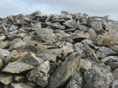
3. But the interesting thing about these accumulations is that they are composed mostly of boulders and big rock slabs weighing more than 100kg. Where have the smaller sharp-edged fragments gone? Could they have been selectively removed?

4. Within 150m of these rock outcrops are the three famous Foel Drygarn burial mounds, built of in excess of 4,000 tonnes of rock slabs and small boulders. The eastern tor is only 30 m from the eastern mound, and the westernmost crag is about 130m away from the western mound. Access between all of these features is easy, and there are well defined interconnecting trackways that look as if they have existed for a very long time. The hillfort entrance, and the main access route from the south, are clearly defined and visible on satellite imagery.
5. Two well defined trackways run approx west-east along the slope at the foot of the western crags, joining the main access track at the hillfort entrance.

6. On a high terrace or bench beneath the group of volcanic ash rags closest to the entrance passage, there are undulating pitted surfaces with slight ridges and mounds which cannot easily be explained by reference to natural processes. These are interpreted as signs of rubble and stone extraction.

1. Along the southern edge of the fortified area on the summit of Foel Drygarn there are four prominent crags and several smaller ones. The biggest eastern crag (one of three) (close to the eastern burial mound) is really a tor made of dolerite, similar in many ways to the other tors scattered across the eastern Preseli landscape. It has obvious traces of ice moulding. The other crags, to the west of the western burial mound, are sharper and more "craggy", and are geologically complex -- made of rhyolite, felspathic tuffs and other rock types associated with extrusive volcanic activity.
2. On the steep slopes on the southern flanks of these rock outcrops there are, as you might expect, rockfall accumulations associated with frost-shattering and other periglacial processes that have operated over many thousands of years.
3. But the interesting thing about these accumulations is that they are composed mostly of boulders and big rock slabs weighing more than 100kg. Where have the smaller sharp-edged fragments gone? Could they have been selectively removed?
The easternmost dolerite tor, with a jumble of rockfall debris from which most of the finer
material has been removed. The two smaller dolerite tors (see image at the top of this post) have been substantially "cleaned up" through the removal of debris.
4. Within 150m of these rock outcrops are the three famous Foel Drygarn burial mounds, built of in excess of 4,000 tonnes of rock slabs and small boulders. The eastern tor is only 30 m from the eastern mound, and the westernmost crag is about 130m away from the western mound. Access between all of these features is easy, and there are well defined interconnecting trackways that look as if they have existed for a very long time. The hillfort entrance, and the main access route from the south, are clearly defined and visible on satellite imagery.
The surface of one of the burial mounds. This is typical scree / rockfall material -- all derived from the adjaacent igneous crags. The rocks are of dolerite, rhyolite and ash -- suggestive of collection from many different locations around the hill summit.
5. Two well defined trackways run approx west-east along the slope at the foot of the western crags, joining the main access track at the hillfort entrance.
On this image, left of centre, we can see the trackway leading to the hillfort entrance. It also connects the three burial mounds with the quarrying area, and must have been used as the stone transport route prior to the construction of the hillfort.
6. On a high terrace or bench beneath the group of volcanic ash rags closest to the entrance passage, there are undulating pitted surfaces with slight ridges and mounds which cannot easily be explained by reference to natural processes. These are interpreted as signs of rubble and stone extraction.
7. Beneath the more spectacular crags to the west, there is a lower terrace which must originally have supported thick accumulations of rockfall debris and scree. Much of this debris has been removed. The extraction pits are clearly visible, separated by ridges of grassed-over rubble c1m high.
8. In gullies between the crags we can still see accumulations of scree, with sharp-edges slabs and blocks that are virtually identical to the fragments seen on the burial mounds.
Rockfall debris exposed in a gully beneath the western crags
I have not mapped this site carefully, or conducted any excavations; but I am confident that we have all the characteristics of a Bronze Age (and possibly later) stone quarry -- not used for monoliths, but for rubble and easily transported slabs. We have a destination for this material, an adjacent source, and a transport route. We have a motivation, and we have many physical traces that cannot, I think, be explained by reference to natural processes.
Quarrying activity here was much more extensive than indicated on the 1968 RCAHMW map.
As I mentioned in an earlier post, no elaborate engineering and no quarrying tools were needed here. Stones were just picked up from the scree and rubble derived from rockfalls, and carried away, mostly by individuals and maybe sometimes (for stones weighing over 20 kg) by a couples of men working together.
So this is a quarrying site, and I make no apologies for referring to it as such. If anybody wants to argue with me, let's have an interesting conversation........
==============
PS. Now here is an interesting question. Did the people who built the burial mounds and took the stone from the quarries have access to wheeled vehicles? They might have done -- apparently wheels first appeared in the Bronze Age in Britain. But if they did, the vehicles were probably very heavy, with solid wooden wheels cut from tree trunks. They might have been useful on dry flat land -- but for carrying loads of rocks uphill in this challenging terrain? I have my doubts.
Thank you for such an informative read😊 we really don’t appreciate our wonderful surroundings!!
ReplyDeleteWhat an incredible life you have had.
HI Brian
ReplyDeleteThank you for an interesting insight!
Why do you think that the later Iron Age Fort builders left the the earlier Bronze Age Cairn structures intact? Especially as there was 4000 tones of ready to use stones on the peak of the summit? Why make shifting thousands of tons of stones harder than neccesary? Lot easier to move such stones dowhill rather than uphill! There may have been up to a thousand years between the two periods. The population demograph may have totally changed in that time. Why a thousand years later would anyone want to build a town surrounding the burial cairns of now forgotton people? There are plenty of enigmas surrounding the Preseli, Neolithic/Bronze/Iron Age peoples.
Carningli and its hillfort (why there?), with its neolithic markers eg Trellyffaint Careg Coetan etc, is also a mystery as is Carn Alw and Castell Mawr, which is a most unusual hillfort more reminiscent of a henge! There are so many ancient features in the Preseli landscape.
Personallly from what I have identified at many other Welsh Hillforts, the enclosed areas where extensively manicured or flattened to provide flatish footings for the Hut buildings and surrounding pavings. There are 250 odd hut foundations on Drygarn making it a small town or citadell!
Could the "Iron Age" element simply have been much earlier coinciding with the cairn builders, or perhaps vice versa, in which case the builders of the cairns and the fort revetments may have sourced the bulk of the material from what was once a very rocky summit, which was flattened? How many tons of stones and felled trees constructing the forts walls, would that be?
Also, I have read some very old texts from the area of the Cellan parish which spoke of a now lost tradition for cairns, it stated that it was tradition and plain good manners for passers by, travelers and pilgrims to source a suitable good sized stone/rock and to pile it onto the cairn before moving on. The cairn was often a notable local or cheiftan' burial mound and by casting a stone onto the cairn, it showed respect to the deceased and for the afterlife.
Do you think there is any truth to the local lengend that the three cairns are actually long collapsed Beehive Cairn structures? It certainly appears possible by above drone shots that may have been the case? What do you think?
I also heard the cairns and some of the other Preseli crags may have been used as target practice during the war.
The ancient Preseli landscape in my humble opinion is a mystery wrapped up in an enigma!
Thanks again
Steve DB
Oh dear, oh dear. A hypothesis derived by applying the most parsimonious explanation of processes, investigated by careful analysis of features on the ground, without the application of any predetermined ruling hypothesis. I don’t think you’re ever likely to be offered a job at the UCL Institute of Archaeology, Brian.
ReplyDeletehaha -- Thanks, both Steves. Steve P --I think I have long since burnt my boats with UCL. It's too late in life for me to move on anyhow -- I think I'll just be content with the Dept of Glacial Geomorphology at the University of Cilgwyn, where we try to maintain standards..
ReplyDeleteSteve DB -- many interesting points. Yes, I suspect that there may well be more mixing up of features than we are led to believe. The Iron Age residents of these sites may have been potting about and adapting much older features. The archaeologists have suspected this at Carningli too -- but the evidence is difficult to identify..... so they said there may be unidentified Bronze Age elements in the Iron Age features around the summit.
Tom Flowers says...
ReplyDeleteHas "Anonymous" put the hex on you by saying what a wonderful life you have had, Brian? Me too, being the same 82 years of age.
The disrespectful little shite!!!
May you and I live to see 100, Brian, for we are worth one hundred of him or her.
Replying to NostramatiDB
ReplyDeleteThose are good questions and as a (somewhat lapsed) archaeologist I'd have to say, nobody has definite answers. I doubt that any of the cairns have been properly excavated (at least, not in modern times) to produce definitive dating evidence. They do look like typical Bronze Age monuments though, of which there are many others in the general area. And the enclosing banks and walls look like typical Iron Age features. Some excavation of 'huts'by Baring Gould in 1900 revealed artefacts consistent with late prehistoric/Romano-British occupation.
It's possible that the 200 house/hut platforms were not all constructed or occupied at the same time, or they might have been occupied seasonally while the surrounding uplands were grazed during the summer months. There is also the possibility that these structures,'hillforts' were more ceremonial than defensive, places for meeting, trading and feasting - so held a large population for a short time - like many others of the genre it has no proper water supply, a big issue if they were intended for long term use.
As for why Iron Age people built around the burial mounds of an earlier people, and without mining the mounds for building stone? The answer is probably that stories (in a time before reading and writing was general) passed down through the generations held that the cairns were in some way sacred or special, and even protective for the surrounding land. Although now we set a lot of store by science and less by stories, in earlier but still recent times stories of pixies, faeries and magic were often linked to Bronze Age mounds and it's quite possible that those stories originated in pre-Roman times. We think of them as 'burial' sites but for our ancestors they were powerful, magical places. And hence many have survived even into the 21st century.
I have no idea who "Anonymous" was, but let's be generous and think that it was a kind comment, sincerely made....... I may or may not be cursed, but prefer to think I am blessed! And while I am about it, blessings be upon the Welsh rugby team when they play France tomorrow.
ReplyDeleteNice points, Olwyn. I'm quite prepared for the dating to be somewhat cockeyed. Everything turns out to be more cockeyed than we first expected -- but I hope my posts encourage somebody to do some serious research up there......
ReplyDelete