THE BOOK
Some of the ideas discussed in this blog are published in my new book called "The Stonehenge Bluestones" -- available by post and through good bookshops everywhere. Bad bookshops might not have it....
To order, click
HERE

Tuesday 31 March 2020

Human transport -- a good story that got in the way of the facts.....


A review just published in the Proceedings of the Open University Geological 
Society, Vol 6 (2020), p 113.


Monday 23 March 2020

Jon Gower on Mynydd Preseli


Thanks to Tony for alerting me to this -- one of a series of "essays" on the mountains of Wales by Jon Gower.  This one is about Mynydd Preseli  -- pleasant listening -- rather poetic and whimsical -- but interestingly enough, his whimsy does not go so far as to accept the myth of the human transport of the bluestones to Stonehenge.  He prefers the glacial transport idea, so sound science clearly does have some value, even for non-scientists........

The 14 minute talk can be accessed on BBC Sounds, and you can listen on your computer just by signing in.

https://www.bbc.co.uk/sounds/play/m000gcrp

Those funny old sarsens


This is an inspired shot of some of the Stonehenge sarsens, as you have probably never seen them before.  To me, they look like some of the famous stone heads and hats of Easter Island.......  I bet somebody is working on a theory that some of the builders of Stonehenge set off on a great ocen-crossing expedition and settled on Easter Island --- or vice versa.


.... and grateful thanks to Neil Wiseman for sending this pic.  Quite wonderful!  What we see is very clearly an army of petrified trolls, on the warpath, marching towards us.  Be very afraid!


Thursday 19 March 2020

Submerged forests map (update)


The map has been updated, through the addition of Pendine (see the recent post) and Broad Haven.  On a recent Facebook group page, there were confirmations from Anne Rogers and Mary Butcher that they have both seen the submerged forest -- including tree stumps -- on the beach at Broad Haven.  Unfortunately, neither of them has photographs.......

I have also added more "candidate sites" since I am convinced that almost ALL of the sandy embayments around the coast will have peat beds and tree relics under the sand -- ready to be exposed by the "right" combinations of winter storms, tidal scour and wave height and wind direction factors.  There will also be submerged forest relics in abundance within the Milford Haven waterway -- but here of course storm wave conditions capable of "stripping out" sediment in vast quantities are hardly ever seen.

Postscript (7th June 2020)
Thanks to Charles Mathieson for digging up a reference for St Brides.  Apparently in Lewis's Topographical Dictionary of Wales, dated 1833, there is a reference to tree stumps being exposed on the foreshore during an extreme low tide event.   I will alter the definitive map accordingly......... 

More bluestone paranoia


This was on the BBC web site today -- the National Park obviously felt like putting out a press release, to take our minds off the corona virus hysteria.  I'm all in favour of seeing our historic sites protected from vandalism, and of course I condemn any thefts from historic sites like Pentre Ifan, or any form of desecration.   But we do need to keep a sense of proportion.   For a start, it is not a crime to sell bits of spotted dolerite or any other bits of "sacred" stone from the Preseli uplands.  You can take lumps of stone from your garden or from your fields and do with it what you like -- if you want to sell  bits and pieces on Ebay, that's a valid form of farm diversification.  What we do not want to see is lumps of spotted dolerite chopped off the tors within protected areas........

But the NPA does itself no favours by constantly flagging up the so-called mystical link with Stonehenge.  When Tomos Jones, the NPA archaeologist, says ""There are regular problems with fires on what are remote sites in the Preseli Hills, where we now know stones for Stonehenge were cut"  he is over-egging the pudding, because we do NOT know that stones were "cut" from the hills at all.  That is a myth perpetrated, without adequate supporting research, by certain archaeologists.  If the NPA does that sort of irresponsible marketing of the hills, deliberately enhancing the "value" of the stones from specific locations, they should not be surprised if some silly people want go up there and get a bit of the action.......

-----------------------

Historic Welsh sites to be protected by vandalism patrols

• 16 March 2020

https://www.bbc.co.uk/news/uk-wales-51872715

Plans to tackle heritage crime have been extended to protect historic sites across Wales.
Archaeologists, national park officials and Dyfed-Powys Police officers were due to hold a meeting at the weekend to discuss concerns about vandalism.
The conference was cancelled because of coronavirus fears but was due to identify areas at risk of damage and offer training to protect remote sites.
Police, Cadw wardens and park rangers will regularly patrol sites.
There are thousands of heritage sites around Wales, ranging from stone age monuments to World War Two buildings.Incidents include the daubing of a Neolithic burial chamber with animal blood and bluestone fragments from rocks linking Pembrokeshire with Stonehenge being sold online.
A heritage watch scheme was launched by Pembrokeshire Coast National Park two years ago.
Dyfed Archaeological Trust and Dyfed-Powys Police have also joined the scheme, establishing a team of 10 officers trained in dealing with reports of crimes at monuments.
'These monuments cannot be replaced'
Tomos Jones, archaeologist for the Pembrokeshire Coast National park says the types of crimes which threaten the sites were extremely varied.
"At Pentre Ifan we found daubing using animal blood - possibly the result of some ritual," he said.
'International significance'
"There are regular problems with fires on what are remote sites in the Preseli Hills, where we now know stones for Stonehenge were cut.
"There have been cases of people chipping away the remaining bluestones and damaging cairns.
"Some of the bluestone fragments have appeared on eBay."
Insp Reuben Palin, Dyfed-Powys Police lead for heritage crime, said: "We are fortunate to have a number of ancient monuments and archaeological sites in our force area that are of immense national and international significance, and attract visitors from across the world.
"These monuments cannot be replaced, and it is part of our duty to ensure they are protected."

Submerged forest - Swansea Bay and Gower


Swansea Bay -- foreshore in front of Singleton Park (3 photos)


I found some nice pics of the submerged forest around Gower and in Swansea Bay -- on Adam Tilt's blog:

https://www.mylifeoutside.co.uk

These next 3 photos are from Broughton Bay:


Adam says that there are similar exposures in Port Eynon, Whiteford and elsewhere......  Not much peat, by the look of it, but a lot of estuarine mud......

But this is a curious feature on Whiteford Sands.  Looks like a bomb crater (it's 8 ft in diameter) with a thinnish layer of peat or peaty silt thrown up around the circumference.....  What is it?  Answers on a postcard please........


Submerged forest exposures, Whiteford Sands (photo: Pembs Coastal Photography)

Wednesday 18 March 2020

The submerged forest compendium


Borth

During the last fortnight or so there has been a flurry of activity, involving many observers, concentrating on the submerged forest exposures around the West Wales coast.  To make it easier for those who might want to follow up on all this, here is a list of the key posts:

28 Feb   Newgale
https://brian-mountainman.blogspot.com/2020/02/newgale-2020-exposures-of-submerged.html

29 Feb  Amroth
https://brian-mountainman.blogspot.com/2020/02/devensian-till-at-amroth-eureka-moment.html

1 March  Amroth
https://brian-mountainman.blogspot.com/2020/03/the-submerged-forest-at-amroth.html

3 March -- Blue clay -- and Marros, Ynyslas and Clarach
https://brian-mountainman.blogspot.com/2020/03/submerged-forest-and-that-enigmatic.html

3 March  Lydstep
https://brian-mountainman.blogspot.com/2020/03/lydstep-submerged-forest-pig-and.html

3 March  Abermawr and other sites
https://brian-mountainman.blogspot.com/2020/03/submerged-forest-exposures.html

4 March  Submerged forests map for Pembrokeshire
https://brian-mountainman.blogspot.com/2020/03/pembrokeshire-submerged-forests-map.html

5 March Sea level curve
https://brian-mountainman.blogspot.com/2020/03/a-new-sea-level-curve.html

5 March The missing millennia
https://brian-mountainman.blogspot.com/2020/03/those-missing-millennia.html

6 March  South Wales peat beds
https://brian-mountainman.blogspot.com/2020/03/the-other-south-wales-peat-beds.html

8 March  Sedimentation cycles
https://brian-mountainman.blogspot.com/2020/03/sedimentation-cycles-on-submerging-coast.html

9 March  Exploitation
https://brian-mountainman.blogspot.com/2020/03/exploitation-of-submerged-forest.html

13 March Forest growth / rising shoreline
https://brian-mountainman.blogspot.com/2020/03/forest-growth-on-rising-shoreline.html

14 March  The 7,000 BP eustatic event
https://brian-mountainman.blogspot.com/2020/03/the-7000-bp-eustatic-event.html

15 March  The time sequence
https://brian-mountainman.blogspot.com/2020/03/the-submerged-forest-time-sequence.html

16 March  Freshwater West
https://brian-mountainman.blogspot.com/2020/03/freshwater-west-submerged-forest.html

17 March  Gravel Bay
https://brian-mountainman.blogspot.com/2020/03/the-gravel-bay-boulder-field-freshwater.html

18 March  Pendine
https://brian-mountainman.blogspot.com/2020/03/submerged-forest-discovery-at-pendine.html

=============

This is now by far the most substantial source of information on the West Wales submerged forest, incorporating (with many thanks) valuable photos and observations from many contributors.

The resource is free for the use of others, and the URLs of relevant pages can be cited as references where appropriate.  We will appreciate citations, and please remember that if photos are reproduced, it is good practice to cite the photographers (where known) by name.  They should be approached directly if higher resolution images are needed.

======================


Newgale.  Janet Jenkins, 2014


.....and some older posts

20 Sept 2018  Freshwater West
https://brian-mountainman.blogspot.com/2018/09/the-whale-in-forest.html

10 Nov 2019  Newport
https://brian-mountainman.blogspot.com/2019/11/cemented-till-traeth-mawr-newport.html

28 May 2019  Borth
https://brian-mountainman.blogspot.com/2019/05/exposures-of-submerged-forest-at-borth.html

5 March 2019  Abermawr
https://brian-mountainman.blogspot.com/2019/03/holocene-peat-beds-exposed-again-at.html

14 Feb 2018  Abermawr
https://brian-mountainman.blogspot.com/2018/02/abermawr-holocene-sediments.html

13 Feb 2018  Abermawr
https://brian-mountainman.blogspot.com/2018/02/submerged-forest-at-abermawr.html

22 Jan 2018  Abereiddi
https://brian-mountainman.blogspot.com/2018/01/submerged-forest-abereiddi.html

18 May 2016  Borth
https://brian-mountainman.blogspot.com/2016/05/bronze-age-red-deer-antlers-found-at.html

14 Feb 2016  Freshwater West

Submerged forest discovery at Pendine

Dave Maynard has discovered a peat bed with tree remains at Pendine -- this is exciting, since I am not aware of any previous record of the "submerged forest" being described here.  Many thanks to him for sharing the info plus some of his observations.

He has done some splendid drone photography, and has mapped the outcrop in great detail by combining several drone images:


On the image, the peat exposures are shown in green.  They extend over a distance of c 280 m, very close to the village at the western end of the beach.


The exposures are in the vicinity of the dark-coloured rocks partly submerged by the sea in the intertidal zone, between Dolwen Point and Gilman Point.  Grid ref:  SN 23216 07770.

This exposure is very different from most of the others in West Wales, which are generally found in wide sandy bays in association with sandy beaches and storm beaches of pebbles.  Here, there is a close association with a high cliffline and abundant rockfall debris.

This is how the area looks (without all the cars) when the sandy beach is in "summertime" mode:


When Dave visited, a lot of sand had been moved out by the winter storms, and this is one of the images he obtained:


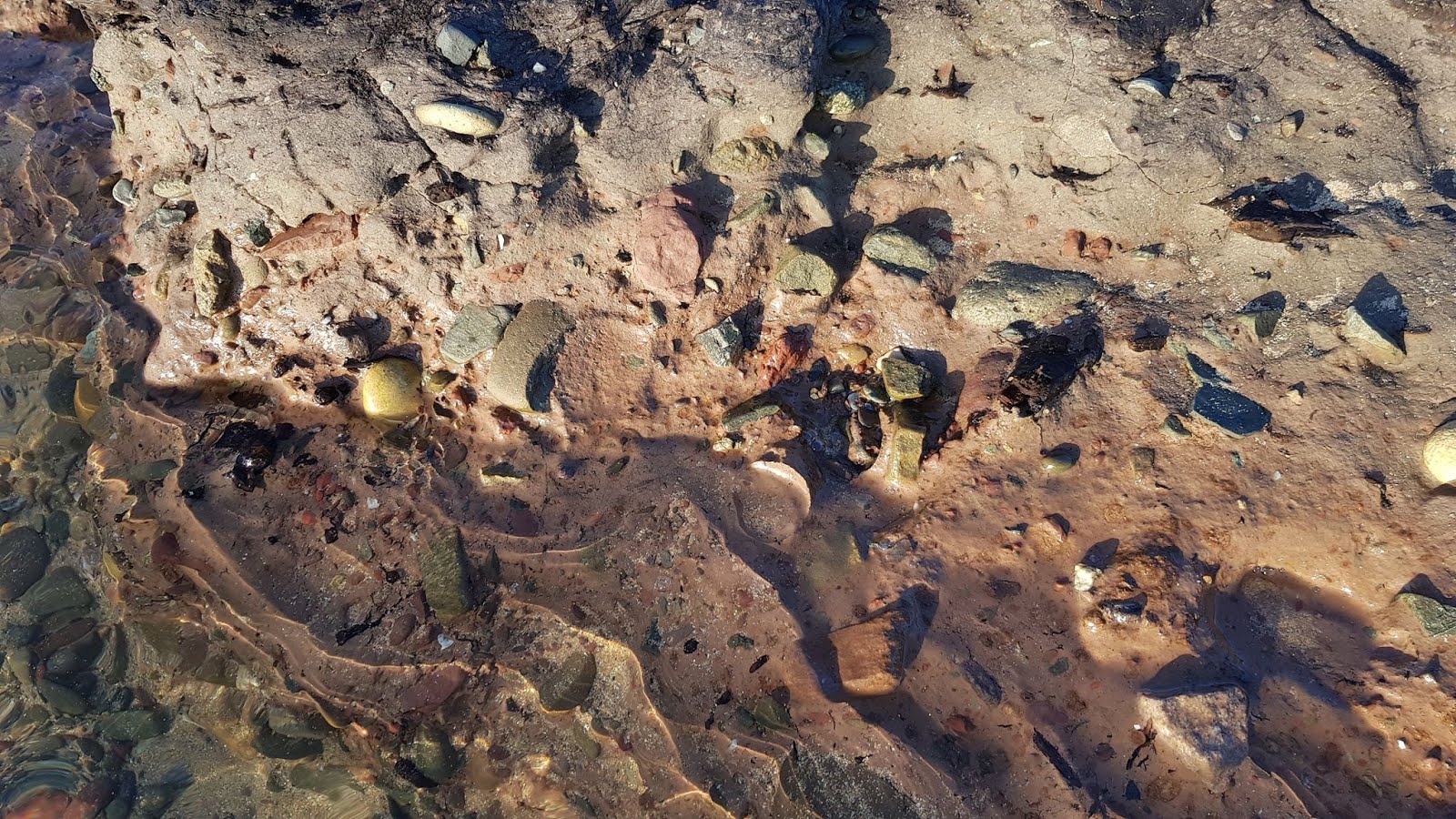
Oblique image from Dave's drone footage.  The edge of the peat bed can be seen clearly, running from approx 1 pm to 7 pm.

This is a general view showing the peat bed overlain by wave-washed and partly rounded rockfall debris, not far from the cliff face.


Dave's description:

There doesn't appear to be a record of anything on this beach, because it is only visible in fragmentary pieces and the big shows of material is west of here. Also is very noteworthy that the peat is heavily covered with rockfall from the cliff and the rapid movement of sand. The peat is low in the ground and often at the base of pools of water. No stories of blue clay underneath here! The best you will see is the peat surface pocking out through gaps in the sand.

One very strange observation is stratified deposits of sandy material forming a conglomerate, which is hard, but can be scratched away. This looks like old beach deposits formed about 4-5m inland of the peat and up against the rock debris. In places, there are large blocks that look like breccia incorporated in this sand deposit that have been broken up by wave action and tumbled around.


On the images, it looks as if there are rockfall boulders both underneath and on top of the peat layer.  Because the peat is at a low level, there are no exposures of blue clay beneath it, but this photo shows that beneath the peat bed there is a fine-grained brown silty deposit containing scattered lumps of bedrock.


This might be till, but it looks more like a colluvium containing local angular and sub-angular bedrock fragments.........  does it contain organic debris or roots, pollen or maybe foraminifera, or maybe even Scrobicularia fragments?  Is it a land or freshwater deposit, or something from the intertidal zone?

On some of Dave's images there appears to be a rock platform (presumably a wave-cut platform) just under the surface litter of boulders, so we can probably assume that the full sequence of deposits is less than 2 m thick.

Scattered around among the boulders and other rockfall debris there are broken chunks of "sandrock"  -  generally interpreted as cemented dune sand and often found in association with the interglacial raised beach.  (The cliffs here are made of Carboniferous Limestone, with abundant caves, but I am not sure if there are any remnants of the raised beach platform or any in situ patches of the raised beach or the cemented sands.....)  Prof David Bowen has noted that around Gilwen Point and Ragwen Point there are several exposures of cemented blocky slope breccia (head) on the cliff slopes, and also "several facies of raised beach beach shingle separated by cemented sand....." (GCR Review volume, p 83).  From looking at Dave's photos, there do appear to be three different sorts of  cemented material represented:  relatively fine-grained sandrock, presumably from old sand dunes; a cemented slope breccia full of angular fragments; and a "conglomerate" which seems to contain a greater proportion of rounded pebbles -- maybe from a remnant of the raised beach?


An exposure of cemented breccia which seems to contain some less angular material.  Could it be a cemented till?  Or even something related to the interglacial raise beach?  And does it project through the peat, or is it a detached block sitting on the surface?


So -- is there any genuine and unmodified till at this location, beneath the peat?  It may be that there is just a stony colluvium, but a small excavation might give the answer.......

The stratigraphic relationships of these assorted deposits are currently something of a mystery.    All will no doubt be revealed, in time.......

=================

As a matter of interest, Prof David Bowen claimed that the Pendine - Marros area was unglaciated during the Late Devensian.  On p 149 of "The Glaciations of Wales and Adjacent Areas" (2005) he published a photo of the lee side of Gilman Point, showing coarse rockfall debris / slope breccia at the base, and finer "scree" above (several facies), with a variable matrix of "finer slope wash material".


Exposure on the lee (east) side of Gilman Point -- showing very coarse limestone rockfall debris at the base, overlain by finer slope breccia (Photo: DQ Bowen)

Bowen claimed that there are no erratics in these deposits, and that the "entire exposure represents all of the last (ice age) glacial cycle."  This may be true, but we must bear in mind that there is till at Amroth and Marros, not very far away, and that on the geological map till is shown in Pendine, on Pendine Hill, and in the valley of Morfa Bychan, to the west of Gilman Point.  Is this till ancient, or Late Devensian?

Morfa Bychan Bay and Gilman Point.    The expanse of till is in the section of the 
valley closest to the camera.


Tuesday 17 March 2020

The Gravel Bay Boulder Field, Freshwater West


Let's call it the "Gravel Bay Boulder Field".  It's located in area A on the above annotated satellite image, at the northern extremity of Freshwater West Bay.

This is a fringe benefit -- before visiting the site yesterday I did not know that this boulder field existed, let alone that it was rather important..........  Anyway, we are lucky to have some great photos from Jamie Crofts, and we thank him for permission to use them here:


The submerged boulder field (currently not submerged) with the setting sun beyond.  There is a lot of standing water here, suggesting that the deposit is quite thin, and that undulating bedrock is not far down.


There are large boulders here, and stones and cobbles of all shapes and sizes.  There are thousands of erratics, and many boulders of local Old Red Sandstone and other rocks from the neighbourhood.  This accumulation is nothing like a storm beach deposit, and is quite different from the rockfall accumulations we see beneath the sand in many Pembrokeshire bays.  These boulders and cobbles -- and finer gravels too -- can only have come from a deposit of glacial till. The fines have simply been washed away.  But when -- and how?


An exposure of bedrock projecting through the boulder field.  It appears to be an undulating and somewhat broken up rock platform made of Upper Silurian mudstones and sandstones. 


Another exposure of broken bedrock projecting through the boulder field.


I hoped that this would be here, but missed it because it was almost dark when I visited.  But Jamie and Ruth spotted it during their visit, and it confirms that there are a few remnants of coherent till still surviving in the boulder field.  Jamie says that the deposit is partly cemented.  Note the 
reddish colour -- reminiscent of the meltout tills deposits of West Dale, 
West Angle, Ballums Bay, Caldey, and various clifftop coastal sites along the South Pembrokeshire coast.  


In this photo, we see (I think!) a peat exposure beneath the water line.  That's interesting -- and it shows that the stratigraphy has been inverted in some places -- with washed out stones and boulders thrown on top of the peat beds.  More work needed.....

Click to enlarge all these photos from Jamie -- the definition is amazing.


Monday 16 March 2020

Freshwater West -- the submerged forest sedimentary sequence


Our "opportunistic community science project" rolls on!  The submerged forest exposures are still there, accessible and inviting investigation, and for the first group of these photos we must thank Ruth Crofts, who has been to Freshwater West with her son Jamie. (Jamie is working on a dissertation relating to the submerged forest exposures.)  Fabulous images, which confirm the conclusions from 2016, when I published some photos from Ivan Wooll.

RUTH'S PHOTOS


There don't seem to be many tree remains (fallen branches, trunks, root stocks, leafy remains, nuts etc) here, but there is a good dark peat up to 20 cm thick, indicative of freshwater waterlogged conditions free of saltwater influence.  On the surface of the peat there are scattered stones of many shapes and sizes; these have almost certainly come from the marine exploitation of the underlying till layer in gullies during storms.  As we can see, these erosional gullies are more than a metre deep.  In places there is a sharp break between the peat and the grey-blue silty clay beneath.  Let's call this the "blue clay layer", as at other sites.  But it's interesting that the sediments have a quite high organic content higher up, and that this reduces downwards.  This layer is about a metre thick, and it is penetrated by root systems, as we can see in the photo below:


Does this mean that it is not a marine intertidal clay at all?  Is it quite different in origin from the Scribicularia clay seen in some estuarine situations like Ynyslas and Clarach?  Here the blue clay for the most part appears quite homogenous and is stoneless, but in one of Ruth's photos it appears that the lowest 30 cm or so has traces of banding or layering, with occasional stones inclusions. (Is this "layering" more apparent than real?  We might just be looking at  the effects of sapping along a water-line, as the depth of the pool varies between one low tide episode and the next.  Closer examination needed!)  If there is a sedimentary layering, this would indicate the effects of water action on an exposed till surface.  Something similar is seen in one of Gary's photos from Amroth.

Then there is a sharp break, below which is a stone-rich layer with stones and larger cobbles of all shapes, sizes and lithologies.  We might refer to it technically as a sticky clay matrix-supported diamicton.  At Druidston, Abermawr or Whitesands, I would not hesitate to call this Irish Sea till.  I should not be surprised to find within it pieces of lignite or shell fragments.

The following five photos show the till layer in close-up.  Are there any striated cobbles?  I would guess that that is almost certain.  Some of the pebbles are well-rounded, and of course it is to be expected that any till in a coastal location like this will incorporate not only old sea-floor deposits but also ephemeral storm beach ridges formed offshore at times of lower sea level.


MY PHOTOS (16 March 2020)

I got down to the beach at low tide today, under gloomy conditions, to find that some of the exposures have already disappeared beneath the sand.  But close to the northern end of the beach (SN 88005) there are two notable expanses:  (1) an undulating peat surface with abundant pools and a thin scatter of beach sand, extending over an area of c 100m x 30m; and (2) a stony and gravelly expanse, with scattered erratic boulders of many types, and bedrock outcrops here and there, extending over an area of 100m x 50m.


The "submerged peat", temporarily exposed near the northern end of the bay.  We do  not know how much of the peat bed might have been removed, but it currently 
varies in thickness from 30 cm to zero, with an undulating lower surface.


There are occasional tree remains near the edge of the pebble beach, resting on the peat surface. 


The north-facing "scarp" along which examinations can be made of the peat and clay sequence.

The peat and clay association

On closer examination, some of the clay in the little north-facing "scarp" is stoneless, but most of it is not.  The grey sticky clay till is here ubiquitous, and in some exposures it extends right up the the exposed surface, with no overlying peat at all.  (Of course, it might have been stripped off by wave action.  But the essential association is this:  thin peat resting directly on weathered till.)


In this exposure there is no overlying peat at all, and we see approx 1m of sticky grey clay with occasional stones.  Note he colour variations -- are these the result of late glacial weathering on an exposed till surface?

The clay exposures are very colourful, with the most common sequence of colour changes as follows: at the surface, steel grey, grading down to creamy buff or light brown, grading down to bright blue, grading down to brownish grey, grading down to light grey -- base not seen.  Close to the edge of the storm beach, some of the clay horizons are bright red, possibly indicative of sediments derived from the Old Red Sandstone rocks in the nearby outcrops.

All of the observed clay exposures were riddled with carbonized bits and pieces of root systems, with occasional vertical pieces of tree roots going down to considerable depth. 

The expanse of stones and boulders 

In some ways this is more spectacular and interesting than the peat and clay beds, revealing many thousands of tonnes of pebbles, cobbles, stones and boulders of all shapes and sizes -- and many lithologies, including volcanics apparently from Skomer and Ramsey Island.  Here and there small exposures of bedrock can be seen through the stone layer, so it is not very thick.  Because there is still a lot of beach sand in the hollows, there are still things to be discovered here.  I suspect that there might be till here, under the stones.  But this is essentially a lag deposit, formed following the redistribution of finer materials from what must previously have been either a moraine or a till sheet.


Some of the pebbles from the Freshwater West beach.  Many of these are volcanic in origin -- far travelled erratics derived from the local till.  Photo: Pembs Coastal Photography.

This must be linked to the till sheet exposed through the sandy beach just 20m away to the south........

There are a number of questions that need answering here.  Are the root remains penetrating the till layer very old -- ie pre-Holocene -- or are they simply deep root penetrations linked in some way with the submerged forest / peat bed?   Are there really some banded sedimentary layers that indicate erosion and "re-sedimentation" on an exposed till surface?  And how do we explain the presence of the "blue clay" layer here, where there is no estuarine environment suitable for the transport and deposition of vast quantities of silt?  Could it be a sub-glacial deposit, or is it maybe a product of a pro-glacial and post-glacial washing process on an exposed and undulating till surface, with abundant water-filled depressions?

All in all, I am not convinced that we have signs here of a coastal inundation in the period before the "7 ka event".  This might just have been a freshwater environment right through the period represented by the deposits currently exposed.


The beach as it is in the summer.  The submerged forest expanse and the expanse of stones and boulders are buried beneath the sand, approx in the vicinity of the wet area left of centre.  Pic:  Pembs Coastal Photography.


On the maps this area is referred to as "Gravel Bay" -- I wonder why? The name does not seem very appropriate in the summer, but in the winter, after a few storms, the name seems just fine....

=================


PS.  Just a reminder that Freshwater West was the scene of the find of the remains of a blue whale, which Leach assumed was washed ashore during the destruction of the submerged forest by "an incursion of the sea".    More info here:


====================

PS.  Dated 29 April 2021.  Thanks to Dave Maynard for recording the presence of the peat bed, with tree remains and an underlying "brown soil" in an area of c 20m x 50m, at the southern end of the beach around grid ref SR 88370 99784.  The exposure must be down to some freak combinations of winds, storm waves and tidal currents this spring.......


Sunday 15 March 2020

Those Norwegian Woolly Mammoths


It's a while since I have had contact with the Norwegian Glacier Museum in Fjaerland, very close to the edge of Europe's largest ice cap -- Jostedalsbreen.  So it was fun to come across a photo of the family of woolly mammoths installed outside on the lawn in 2013.  It was even more fun to discover that they were made in Cardiff and transported to Fjaerland by a Welsh haulage company.

Marit Orheim, the powerhouse behind the founding of the museum, was one of our dearest friends, who sadly died some years ago.  But I well recall assorted hilarious evenings during which she planned to get those mammoths installed -- and she was quite determined that they should be named Papputh, Mammuth and Babbuth.  I hope her wish has come true........