
When the Late Devensian glacier ice melted, parts of the coastal landscape probably looked like this. Then came 10,000 years of transformation by surface processes, vegetation growth, and finally submergence beneath a rising sea.......
If, as now seems likely, the LGM in Pembrokeshire was somewhere between 24,000 and 20,000 years ago, there were ten millennia of non-glacial conditions which must have left some mark on the landscape (and on sedimentary sequences) before the spectacular warming of the climate that attended the beginning of the Holocene around 10,000 yrs BP.
I have pondered on this "record gap" before:
https://brian-mountainman.blogspot.com/2013/01/ten-thousand-missing-years.html
Actually it's not so much of a gap as we might think -- there are quite abundant records in peat bogs and other soggy areas across western Britain which show a more or less continuous record of vegetation and sediment accumulation over these ten thousand years. Roughly, the period has become known among specialists as the Late Glacial-Interglacial Transition (LGIT). There is no agreed dating. In some articles the time span is given as 14,000 - 9,000 yrs BP, and in others 16,000 - 8,000 yrs BP. Since there were remnants of glacier ice in the uplands and near the core of the BIIS all the way through to the end of the Loch Lomond stadial around 10,000 years ago, the "deglaciation" date differs enormously from one locality to another. But in Pembrokeshire let's assume that the LGIT started around 20,000 years ago when the Irish Sea Glacier melted catastrophically over just a few centuries.
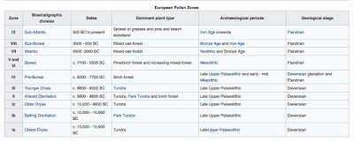
What do we know about the behaviour of climate and the changes in the environment during the period in question? According to Prof Mike Walker and other specialists, the pollen data and radiocarbon dates for Southern Britain show the following:
13. Sub-Atlantic -- 2500 yrs BP to present
12. Holocene -- Sub-Boreal 5,000 -- 2500 yrs BP
11. Holocene -- Atlantic 7,500 - 5,000 yrs BP
10. Holocene -- Boreal c 9,700 - 7,500 yrs BP
9. Holocene interglacial -- Pre-Boreal c10,300 - 9,700 yrs BP
8. Sharp warming -- onset of Holocene c 10,000 yrs BP
7. Younger Dryas (Zone III) cold snap / Loch Lomond readvance c 11,000 -10,000 yrs BP
6. Allerod (Zone II) "interstadial" -- warming 11,800 - 11,000 yrs BP
5. Cooling erratically to Older Dryas (Zone I) 12,000 - 11,800 yrs BP
4. Sharp climate oscillations: mid-Weichselian substage 14,000 - 13,000 yrs BP
3. Bolling "interstadial" -- warming to almost interglacial level, started c 14,700 yrs BP (some dates place this event around 12,500 yrs BP)
2. Continuing cold -- sparse tundra vegetation 20,000 - 15,000 yrs BP
1. Deglaciation around 20,000 yrs BP
Some of this sequence-- with minor variations -- is shown in the graph from Coxon (2008), based on many studies from Ireland:

Some of the differences between the Welsh climate change sequence and that of Ireland are because of real "lag effects" and different geographical contexts, and other differences are down to different dating conventions (BC, BP, radiocarbon years, corrected or uncorrected.....). Here is another representation of the period in question -- note that the choice of "bounding dates" for the various climatic oscillations is a somewhat subjective matter........ Note also that oxygen isotope readings and the MIS designations are based on data from currently glaciated areas and ocean cores, that the oscillations are not necessarily traceable in Wales, that there may be lag effects, and that local topography and climate may have induced local coolings and warmings not represented elsewhere. So correlations are necessarily somewhat hazardous.

Very broadly, if we seek to generalise and smooth out some of the oscillations in these records, we see this:
1. a cold or periglacial episode lasting from 20,000 - 15,000yrs ago;
2. then a period of warming between 15,000 and 13,000 yrs BP;
3. then a period of very sharp climatic oscillations (incorporating Zones I, II and III) between 13,000 and 11,500 yrs BP;
4. then a period of sharply rising temperatures marking the onset of relatively stable interglacial (Holocene) conditions around 10,000 years ago;
5. since then the oscillations have been quite small.
This is the overall LGIT pattern, backed up by a wealth of research data and more or less agreed among experts, against which we can seek to interpret landscape change and sedimentation since the Devensian glacier ice melted away.
Next, we need to know how sea level was behaving. Here is the key graph again:

When the Devensian ice melted away, sea-level was at least 120 m lower than it is now. As the northern Hemisphere ice sheets melted catastrophically phenomenal amounts of water were added to the global ocean, and between 9,000 and 7,000 years ago sea level continued to rise at a rate of c 1 m per century. Then, when sea-level was at around -3 m, there was a dramatic change, and after that, from the Atlantic period until the present day, the rise has varied a little but has averaged only 8 cm per century or 80 cm per thousand years. That's quite a slow rate of rise, and rates of surface sedimentation and plant growth might well have exceeded that, resulting in a shoreline regression under suitable circumstances; but we must remember that in areas with a high tidal range (as much as 8m on the south coast of Pembrokeshire) the intertidal zone around the coast must have been very extensive, with the potential for great damage (and indeed landscape transformations) to occur when storm surges coincided with onshore winds and spring tides. It is in this context that we must seek to understand how the submerged forest was formed, and how it was destroyed.
I have examined all the information on isostatic adjustments around the Pembrokeshire coast, and although there may have been some isostatic uplift in the Aberystwyth - Borth area, close to the wasting Welsh ice cap remnants, I am convinced that there were none in Pembrokeshire. There was no isostatic "bulge"effect (involving crustal downwarping) either. The consensus seems to be that Pembrokeshire was crustally stable, more or less on the UK hinge line.
The lowest sediments in the sequence
Of the 15 submerged forest sites examined in Pembrokeshire, we know that Irish Sea till exists beneath the peat beds and tree remains in a number of sites -- the till is occasionally visible in Traeth Mawr, Newport; Abermawr; Freshwater West; and Amroth. It is almost certainly just out of sight at Newgale and other sites. There are some records (by Leach, North, and the Geological Survey officers) of unstratified rock breccia, rubble or "head" at the base of exposures examined. This is unsurprising -- local conditions, even inside the Devensian ice limit, varied considerably.
The blue clay
As mentioned in the earlier posts on Ynyslas, Clarach, Amroth and Lydstep, the enigmatic sticky blue or grey clay does vary in its characteristics from one site to another, and at Lydstep it was even described as a "loess" (a windblown silt or sand) -- but it is always present and in some places it is thick enough to have been dug out and used for making culm balls or even for pottery making. At Amroth it does contain large stones or boulders, but elsewhere it seems to be stoneless. Might it be -- in some cases at least -- a fluvial alluvium? But there is a common association with Scrubicularia shells, suggesting a maritime rather than a freshwater environment, and it must have been laid down in a low-energy environment such as an intertidal mud-flat or saltmarsh. That means a high fine-grained sediment supply, as we would expect in the vicinity of the Dyfi estuary (in the case of Ynyslas and Clarach) and in the vicinity of the Taf / Tywi estuary (in the case of Marros and Amroth). The radiocarbon and pollen evidence suggests that the blue clay layer was laid down at the culmination of the rapid marine transgression -- around 6,500 years ago. If mid-tide sea-level at that time was 3m - 4m lower than that of the present day, with a maximum tidal range of around 8m, that means that the high tide limit would have been at about present msl or OD. Around that level we would expect to find storm beach or sandy beach materials, with silt and clay materials deposited (as at present) around LWM and in deeper water never exposed to the atmosphere. So we have a problem -- with an apparently deep water deposit in the position where a shallow water deposit should be found.
What other explanation might there be for the clay layer? As suggested earlier, it might have formed from the finer materials eroded from exposed Irish Sea till deposits -- which are widespread in the coastal zone. That might have occurred in freshwater creeks and lagoons far away from the sea, which was at the time far below its present level. But that thesis does not stand up if indeed Scrobicularia shells are always present -- suggesting that the clay accumulated in a marine environment.
But might the clay simply be a "surface washing" product caused by wave action near high tide mark on an exposed surface of till? Maybe. But if that happened, why were the fines (silt and clay) not carried in suspension back down the beach into deeper water?
It is hypothesised at Ynyslas that the shoreline, at the time of the culmination of the rapid sea-level rise, was protected by an offshore bar. That would reduce the effect of wave action on the shore, and might just slow down shoreline processes sufficiently for plant communities to establish themselves to the point where the accretion rate of organic materials and trapped sediments was greater than the rate of sea-level rise after c 6,500 yrs BP. In other words, biological processes trumped the slowing rate of sea-level rise and turned a marine transgression into a regression. That is a "special circumstance", and it is difficult to see how it could have been replicated at most of the other known submerged forest sites. On the other hand it's possible that at other sites a "migrating storm beach" or a shoreline sand dune belt might have existed around HWM, protecting a wetland habitat suitable for silt and clay accumulation on its landward flank. There is evidence for something like this at Newgale and Abermawr.........


The mudbanks of the Dyfi estuary and the Taf/Tywi estuary (containing much silt and sticky clay) are currently exposed above water level for much of the tidal cycle, and they are maintained by high rates of sediment discharge from the rivers involved -- so how was material of this type laid down in a distinct and apparently continuous layer across all of the other sites as well, in areas where there are no large streams carrying a sediment load? The River Nevern was clearly capable of carrying a load of fine-grained sediment into the estuary at Traeth Mawr, Newport; but what about Lydstep, Abereiddi, Abermawr, Freshwater East, Freshwater West, Newgale, Whitesands, Manorbier and many other sites where there are very insignificant streams reaching the coast? Where did the blue and grey clay actually come from?
So -- an enigmatic deposit which seems to represent the culmination of a powerful marine transgression displaying all of the characteristics of a deepwater deposit exposed by a regression to the point where brackish water conditions were replaced by freshwater lagoons and then a wetland forest?
I'm still puzzled. Watch this space.......
=====================
Here is one of many papers on the LGIT:
Climatic changes in areas adjacent to the North Atlantic during the last glacial-interglacial transition (14-9 ka BP): A contribution to IGCP-253.
John Lowe, Brigitta Ammann, Hilary H Birks, M. J. C. Walker et al
June 1994
Journal of Quaternary Science 9(2):185 - 198
DOI: 10.1002/jqs.3390090215
Abstract
This paper presents a summary of the evidence for climatic changes during the last glacial-interglacial transition (14-9 ka BP) in land areas adjacent to the North Atlantic. It is a synthesis of the results of the 12 regional summaries compiled by contributors to the North Atlantic Seaboard Programme of IGCP-253 that are published separately in this issue of Journal of Quaternary Science. Eighteen palaeotemperature curves are compared and arranged in three transects, one from southern Europe to Spitsbergen, a second from Ireland to Poland, and the third from southern New England to the Labrador-Baffin Shelf area. Ten maps are presented that summarise the synoptic climatic conditions of the region in 500-year time periods. The purpose of the exercise is to examine the extent to which any emerging patterns support the Ruddiman and Mclntyre model of large-scale shifts in the position of the oceanice Polar Front during the last glacial-interglacial transition. Some broad agreement emerges, although the influence of oceanic changes is diminished in areas that lay in close proximity to the Laurentide and Fennoscandian ice sheets. Attention is drawn to limitations in the compilations and to the potential for improved models in the future.
Another useful reference, relating to Ireland:
Coxon, Pete. “Landscapes and Environments of the Last Glacial-Interglacial Transition: a Time of Amazingly Rapid Change in Ireland.” The Irish Naturalists' Journal, vol. 29, 2008, pp. 45–61.
As mentioned in the earlier posts on Ynyslas, Clarach, Amroth and Lydstep, the enigmatic sticky blue or grey clay does vary in its characteristics from one site to another, and at Lydstep it was even described as a "loess" (a windblown silt or sand) -- but it is always present and in some places it is thick enough to have been dug out and used for making culm balls or even for pottery making. At Amroth it does contain large stones or boulders, but elsewhere it seems to be stoneless. Might it be -- in some cases at least -- a fluvial alluvium? But there is a common association with Scrubicularia shells, suggesting a maritime rather than a freshwater environment, and it must have been laid down in a low-energy environment such as an intertidal mud-flat or saltmarsh. That means a high fine-grained sediment supply, as we would expect in the vicinity of the Dyfi estuary (in the case of Ynyslas and Clarach) and in the vicinity of the Taf / Tywi estuary (in the case of Marros and Amroth). The radiocarbon and pollen evidence suggests that the blue clay layer was laid down at the culmination of the rapid marine transgression -- around 6,500 years ago. If mid-tide sea-level at that time was 3m - 4m lower than that of the present day, with a maximum tidal range of around 8m, that means that the high tide limit would have been at about present msl or OD. Around that level we would expect to find storm beach or sandy beach materials, with silt and clay materials deposited (as at present) around LWM and in deeper water never exposed to the atmosphere. So we have a problem -- with an apparently deep water deposit in the position where a shallow water deposit should be found.
What other explanation might there be for the clay layer? As suggested earlier, it might have formed from the finer materials eroded from exposed Irish Sea till deposits -- which are widespread in the coastal zone. That might have occurred in freshwater creeks and lagoons far away from the sea, which was at the time far below its present level. But that thesis does not stand up if indeed Scrobicularia shells are always present -- suggesting that the clay accumulated in a marine environment.
But might the clay simply be a "surface washing" product caused by wave action near high tide mark on an exposed surface of till? Maybe. But if that happened, why were the fines (silt and clay) not carried in suspension back down the beach into deeper water?
It is hypothesised at Ynyslas that the shoreline, at the time of the culmination of the rapid sea-level rise, was protected by an offshore bar. That would reduce the effect of wave action on the shore, and might just slow down shoreline processes sufficiently for plant communities to establish themselves to the point where the accretion rate of organic materials and trapped sediments was greater than the rate of sea-level rise after c 6,500 yrs BP. In other words, biological processes trumped the slowing rate of sea-level rise and turned a marine transgression into a regression. That is a "special circumstance", and it is difficult to see how it could have been replicated at most of the other known submerged forest sites. On the other hand it's possible that at other sites a "migrating storm beach" or a shoreline sand dune belt might have existed around HWM, protecting a wetland habitat suitable for silt and clay accumulation on its landward flank. There is evidence for something like this at Newgale and Abermawr.........

The tidal Dyfi estuary -- plenty of silt and clay available.......

The Tywi estuary at Llansteffan -- sediment in abundance
The mudbanks of the Dyfi estuary and the Taf/Tywi estuary (containing much silt and sticky clay) are currently exposed above water level for much of the tidal cycle, and they are maintained by high rates of sediment discharge from the rivers involved -- so how was material of this type laid down in a distinct and apparently continuous layer across all of the other sites as well, in areas where there are no large streams carrying a sediment load? The River Nevern was clearly capable of carrying a load of fine-grained sediment into the estuary at Traeth Mawr, Newport; but what about Lydstep, Abereiddi, Abermawr, Freshwater East, Freshwater West, Newgale, Whitesands, Manorbier and many other sites where there are very insignificant streams reaching the coast? Where did the blue and grey clay actually come from?
So -- an enigmatic deposit which seems to represent the culmination of a powerful marine transgression displaying all of the characteristics of a deepwater deposit exposed by a regression to the point where brackish water conditions were replaced by freshwater lagoons and then a wetland forest?
I'm still puzzled. Watch this space.......
=====================
Here is one of many papers on the LGIT:
Climatic changes in areas adjacent to the North Atlantic during the last glacial-interglacial transition (14-9 ka BP): A contribution to IGCP-253.
John Lowe, Brigitta Ammann, Hilary H Birks, M. J. C. Walker et al
June 1994
Journal of Quaternary Science 9(2):185 - 198
DOI: 10.1002/jqs.3390090215
Abstract
This paper presents a summary of the evidence for climatic changes during the last glacial-interglacial transition (14-9 ka BP) in land areas adjacent to the North Atlantic. It is a synthesis of the results of the 12 regional summaries compiled by contributors to the North Atlantic Seaboard Programme of IGCP-253 that are published separately in this issue of Journal of Quaternary Science. Eighteen palaeotemperature curves are compared and arranged in three transects, one from southern Europe to Spitsbergen, a second from Ireland to Poland, and the third from southern New England to the Labrador-Baffin Shelf area. Ten maps are presented that summarise the synoptic climatic conditions of the region in 500-year time periods. The purpose of the exercise is to examine the extent to which any emerging patterns support the Ruddiman and Mclntyre model of large-scale shifts in the position of the oceanice Polar Front during the last glacial-interglacial transition. Some broad agreement emerges, although the influence of oceanic changes is diminished in areas that lay in close proximity to the Laurentide and Fennoscandian ice sheets. Attention is drawn to limitations in the compilations and to the potential for improved models in the future.
Another useful reference, relating to Ireland:
Coxon, Pete. “Landscapes and Environments of the Last Glacial-Interglacial Transition: a Time of Amazingly Rapid Change in Ireland.” The Irish Naturalists' Journal, vol. 29, 2008, pp. 45–61.
JSTOR,
Accessed 5 Mar. 2020.
No comments:
Post a Comment
Please leave your message here