
Our "opportunistic community science project" rolls on! The submerged forest exposures are still there, accessible and inviting investigation, and for the first group of these photos we must thank Ruth Crofts, who has been to Freshwater West with her son Jamie. (Jamie is working on a dissertation relating to the submerged forest exposures.) Fabulous images, which confirm the conclusions from 2016, when I published some photos from Ivan Wooll.
RUTH'S PHOTOS

There don't seem to be many tree remains (fallen branches, trunks, root stocks, leafy remains, nuts etc) here, but there is a good dark peat up to 20 cm thick, indicative of freshwater waterlogged conditions free of saltwater influence. On the surface of the peat there are scattered stones of many shapes and sizes; these have almost certainly come from the marine exploitation of the underlying till layer in gullies during storms. As we can see, these erosional gullies are more than a metre deep. In places there is a sharp break between the peat and the grey-blue silty clay beneath. Let's call this the "blue clay layer", as at other sites. But it's interesting that the sediments have a quite high organic content higher up, and that this reduces downwards. This layer is about a metre thick, and it is penetrated by root systems, as we can see in the photo below:

Does this mean that it is not a marine intertidal clay at all? Is it quite different in origin from the Scribicularia clay seen in some estuarine situations like Ynyslas and Clarach? Here the blue clay for the most part appears quite homogenous and is stoneless, but in one of Ruth's photos it appears that the lowest 30 cm or so has traces of banding or layering, with occasional stones inclusions. (Is this "layering" more apparent than real? We might just be looking at the effects of sapping along a water-line, as the depth of the pool varies between one low tide episode and the next. Closer examination needed!) If there is a sedimentary layering, this would indicate the effects of water action on an exposed till surface. Something similar is seen in one of Gary's photos from Amroth.
Then there is a sharp break, below which is a stone-rich layer with stones and larger cobbles of all shapes, sizes and lithologies. We might refer to it technically as a sticky clay matrix-supported diamicton. At Druidston, Abermawr or Whitesands, I would not hesitate to call this Irish Sea till. I should not be surprised to find within it pieces of lignite or shell fragments.
The following five photos show the till layer in close-up. Are there any striated cobbles? I would guess that that is almost certain. Some of the pebbles are well-rounded, and of course it is to be expected that any till in a coastal location like this will incorporate not only old sea-floor deposits but also ephemeral storm beach ridges formed offshore at times of lower sea level.


MY PHOTOS (16 March 2020)
I got down to the beach at low tide today, under gloomy conditions, to find that some of the exposures have already disappeared beneath the sand. But close to the northern end of the beach (SN 88005) there are two notable expanses: (1) an undulating peat surface with abundant pools and a thin scatter of beach sand, extending over an area of c 100m x 30m; and (2) a stony and gravelly expanse, with scattered erratic boulders of many types, and bedrock outcrops here and there, extending over an area of 100m x 50m.


The peat and clay association
On closer examination, some of the clay in the little north-facing "scarp" is stoneless, but most of it is not. The grey sticky clay till is here ubiquitous, and in some exposures it extends right up the the exposed surface, with no overlying peat at all. (Of course, it might have been stripped off by wave action. But the essential association is this: thin peat resting directly on weathered till.)

There are a number of questions that need answering here. Are the root remains penetrating the till layer very old -- ie pre-Holocene -- or are they simply deep root penetrations linked in some way with the submerged forest / peat bed? Are there really some banded sedimentary layers that indicate erosion and "re-sedimentation" on an exposed till surface? And how do we explain the presence of the "blue clay" layer here, where there is no estuarine environment suitable for the transport and deposition of vast quantities of silt? Could it be a sub-glacial deposit, or is it maybe a product of a pro-glacial and post-glacial washing process on an exposed and undulating till surface, with abundant water-filled depressions?
All in all, I am not convinced that we have signs here of a coastal inundation in the period before the "7 ka event". This might just have been a freshwater environment right through the period represented by the deposits currently exposed.

I got down to the beach at low tide today, under gloomy conditions, to find that some of the exposures have already disappeared beneath the sand. But close to the northern end of the beach (SN 88005) there are two notable expanses: (1) an undulating peat surface with abundant pools and a thin scatter of beach sand, extending over an area of c 100m x 30m; and (2) a stony and gravelly expanse, with scattered erratic boulders of many types, and bedrock outcrops here and there, extending over an area of 100m x 50m.

The "submerged peat", temporarily exposed near the northern end of the bay. We do not know how much of the peat bed might have been removed, but it currently
varies in thickness from 30 cm to zero, with an undulating lower surface.

There are occasional tree remains near the edge of the pebble beach, resting on the peat surface.

The north-facing "scarp" along which examinations can be made of the peat and clay sequence.
The peat and clay association
On closer examination, some of the clay in the little north-facing "scarp" is stoneless, but most of it is not. The grey sticky clay till is here ubiquitous, and in some exposures it extends right up the the exposed surface, with no overlying peat at all. (Of course, it might have been stripped off by wave action. But the essential association is this: thin peat resting directly on weathered till.)

In this exposure there is no overlying peat at all, and we see approx 1m of sticky grey clay with occasional stones. Note he colour variations -- are these the result of late glacial weathering on an exposed till surface?
The clay exposures are very colourful, with the most common sequence of colour changes as follows: at the surface, steel grey, grading down to creamy buff or light brown, grading down to bright blue, grading down to brownish grey, grading down to light grey -- base not seen. Close to the edge of the storm beach, some of the clay horizons are bright red, possibly indicative of sediments derived from the Old Red Sandstone rocks in the nearby outcrops.
All of the observed clay exposures were riddled with carbonized bits and pieces of root systems, with occasional vertical pieces of tree roots going down to considerable depth.
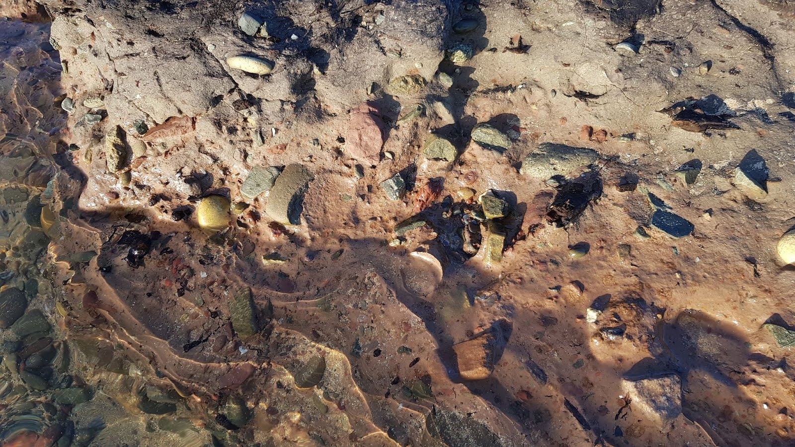
The expanse of stones and boulders
In some ways this is more spectacular and interesting than the peat and clay beds, revealing many thousands of tonnes of pebbles, cobbles, stones and boulders of all shapes and sizes -- and many lithologies, including volcanics apparently from Skomer and Ramsey Island. Here and there small exposures of bedrock can be seen through the stone layer, so it is not very thick. Because there is still a lot of beach sand in the hollows, there are still things to be discovered here. I suspect that there might be till here, under the stones. But this is essentially a lag deposit, formed following the redistribution of finer materials from what must previously have been either a moraine or a till sheet.


Some of the pebbles from the Freshwater West beach. Many of these are volcanic in origin -- far travelled erratics derived from the local till. Photo: Pembs Coastal Photography.
This must be linked to the till sheet exposed through the sandy beach just 20m away to the south........
There are a number of questions that need answering here. Are the root remains penetrating the till layer very old -- ie pre-Holocene -- or are they simply deep root penetrations linked in some way with the submerged forest / peat bed? Are there really some banded sedimentary layers that indicate erosion and "re-sedimentation" on an exposed till surface? And how do we explain the presence of the "blue clay" layer here, where there is no estuarine environment suitable for the transport and deposition of vast quantities of silt? Could it be a sub-glacial deposit, or is it maybe a product of a pro-glacial and post-glacial washing process on an exposed and undulating till surface, with abundant water-filled depressions?
All in all, I am not convinced that we have signs here of a coastal inundation in the period before the "7 ka event". This might just have been a freshwater environment right through the period represented by the deposits currently exposed.

The beach as it is in the summer. The submerged forest expanse and the expanse of stones and boulders are buried beneath the sand, approx in the vicinity of the wet area left of centre. Pic: Pembs Coastal Photography.

On the maps this area is referred to as "Gravel Bay" -- I wonder why? The name does not seem very appropriate in the summer, but in the winter, after a few storms, the name seems just fine....
=================

On the maps this area is referred to as "Gravel Bay" -- I wonder why? The name does not seem very appropriate in the summer, but in the winter, after a few storms, the name seems just fine....
=================
PS. Just a reminder that Freshwater West was the scene of the find of the remains of a blue whale, which Leach assumed was washed ashore during the destruction of the submerged forest by "an incursion of the sea". More info here:
====================
PS. Dated 29 April 2021. Thanks to Dave Maynard for recording the presence of the peat bed, with tree remains and an underlying "brown soil" in an area of c 20m x 50m, at the southern end of the beach around grid ref SR 88370 99784. The exposure must be down to some freak combinations of winds, storm waves and tidal currents this spring.......
No comments:
Post a Comment
Please leave your message here