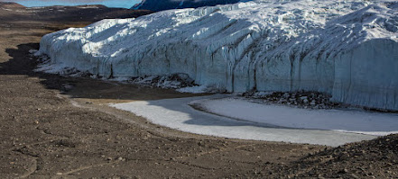
Three low-level aerial photos of the edge of the ice sheet in West Greenland, in areas of modest relief similar to Salisbury Plain. Modelling needed -- but the model must include permafrost and chalk bedrock.....
As the narrative being developed by Parker Pearson and his colleagues becomes ever more complex and ever more ludicrous, thoughts turn to the likely characteristics of an ice edge on or near Salisbury Plain. Was the ice clean, or dirty? What was the temperature regime? Were there any constructional features (terminal moraines or fluvioglacial terraces, for example) at the outermost limit of glaciation? Did the ice melt during the early stages of wastage with a vast amount of meltwater, or was the environment arid enough to ensure much evaporation in the ablation process? Was there a till cover of the landscape following deglaciation, or were there just scattered erratics and a few patches of glacial debris which have subsequently been destroyed by weathering and slope processes? This is a glaciological problem as well as a geomorphological one. Watch this space........How much do we know about Stonehenge? Less than we think. And what has Stonehenge got to do with the Ice Age? More than we might think. This blog is mostly devoted to the problems of where the Stonehenge bluestones came from, and how they got from their source areas to the monument. Now and then I will muse on related Stonehenge topics which have an Ice Age dimension...
THE BOOK
Some of the ideas discussed in this blog are published in my new book called "The Stonehenge Bluestones" -- available by post and through good bookshops everywhere. Bad bookshops might not have it....
To order, click HERE
Some of the ideas discussed in this blog are published in my new book called "The Stonehenge Bluestones" -- available by post and through good bookshops everywhere. Bad bookshops might not have it....
To order, click HERE


No comments:
Post a Comment