
Devensian and earlier glacial limits in the Bristol Channel area, after Gibbard et al, 2017. These are not well supported by the evidence on the ground.
Above map from this article:New insights into the Quaternary evolution of the Bristol Channel, UK
PHILIP L. GIBBARD, PHILIP D. HUGHES and CHRISTOPHER J. ROLFE
JOURNAL OF QUATERNARY SCIENCE (2017)
ISSN 0267-8179.
DOI: 10.1002/jqs.2951
https://www.researchgate.net/publication/318198065
There is much interesting material in this research article, but I part company with them with respect to the lines drawn on the above map. Here are my criticisms:
1. This line, purporting to show the maximum limit of Pleistocene glaciation, incorporates the Fremington deposits but pays no attention to the other glacial traces and giant erratics emplaced along the coasts of Devon and Cornwall. Nor does it take account of the evidence of glaciation in the Somerset Lowlands. It also ignores the evidence of glacial deposits on the hills around Bath, and then runs across the Cotswolds in defiance of topographic controls.
2. This line, showing the proposed "Early Devensian" glaciation limit (in response to equivocal evidence from Lundy), is not supported, as far as I can see, by any other evidence from anywhere. Indeed, all the evidence from the Pembrokeshire coast shows just ONE Devensian ice incursion, during the Late Devensian LGM, with periglacial / permafrost conditions prevailing for maybe 50,000 years before that.
3. Late Devensian glacial limit. There is no clear rationale for this line, which seems to have been drawn so as to accommodate an ice edge wrapped round the northern end of the Isles of Scilly. In unconstrained environments, ice edges do not run parallel with the direction of ice flow, but perpendicular to it. Evidence from Scilly suggests that at the peak of the LGM, the archipelago island summits stood as nunataks above a low-profile ice cover. My guess is that the LGM ice reached the barrier of the Devon - Cornwall cliffline. The proposed line also shows no ice contact with the coasts of South Pembrokeshire; this is contradicted by evidence of fresh till along the coast at least as far east as Caldey Island.
3a. Late Devensian retreat position --- I agree with this one. One of many retreat stages which will gradually be enumerated.
4. The ice free areas and pre-Devensian glacial deposits shown on the map are consequently also inaccurate -- indeed, the deposits shown in Gower, south Pembrokeshire and Preseli are much more likely to be of LGM age.
So if all of that is incorrect, where do we start with trying to understand the glaciation of Southern England generally? How accurate is the Anglian glaciation line shown on the map below?

UK ice limits of various ages. Source: "Age limits on Middle Pleistocene glacial sediments from OSL dating, north Norfolk, UK." by Steven M. Pawley et al
Increasingly, it looks as if the Anglian line is in the wrong place. If we look in more detail at the Bristol-Gloucester region, this is a quite authoritative description of the state of play.
Glacial deposits, Quaternary, Bristol and Gloucester region
Source: Green, G W. 1992. British regional geology: Bristol and Gloucester region (Third edition). (London: HMSO for the British Geological Survey.)Glacial deposits
The glacial deposits of the region are mostly scattered remnants and provide difficult problems of interpretation. The earliest drift deposits are represented by remanié patches of erratic pebbles of quartz, ‘Bunter’ quartzite and, less abundant, strongly patinated flint lying on the surface of or within fissures in the Cotswold plateau up to a height of 300 m above OD. On the eastern boundary of the present region and in adjacent areas to the east, there are scattered patches of sandy and clayey drift with similar erratics, which are now known collectively as the ‘Northern Drift’. The general opinion is that the deposits are heavily decalcified and probably include both tills and the fluviatile deposits derived from them. They predate organic Cromerian deposits in the Oxford area and thus provide evidence for pre-Cromerian glaciation (see summary in Bowen et al., 1986).
High-level plateau deposits in the Bath-Bristol area comprise poorly sorted, loamy gravels with abundant Cretaceous flints and cherts and have been correlated with the ‘Northern Drift’.
The Anglian glaciation is better represented in the district. In the Vale of Moreton there is a three-fold sequence. At the base lies the Stretton Sand, a fluviatile, cross-bedded quartz sand, which has yielded a temperate fauna including straight-tusked elephant and red deer. This was formerly dated as Hoxnian in age but now must be considered to be older. The Stretton Sand is similar to the supposedly younger Campden Tunnel Drift (see below), and it has been suggested that the temperate fauna in it is derived from an earlier interglacial deposit. The overlying Paxford Gravel, which comprises local Jurassic limestone material, has yielded mammoth remains and has an irregular erosive contact with the Stretton Sand. At the top, up to several metres of ‘Chalky Boulder Clay’ with derived ‘Bunter’ pebbles may be present. Thin red clay is locally present immediately beneath the till, possibly representing a feather-edge remnant of the glacial lake deposits of Lake Harrison.
At the northern end of the Cotswolds, in the gap between Ebrington Hill and Dovers Hill, the Campden Tunnel Drift consists of well-bedded sand and gravel with ‘Bunter’ pebbles and Welsh igneous rocks, and two beds of red clay with boulders, probably a till. The deposits occupy a glacial overflow channel, up to 23 m deep, caused by the ponding of the Avon and Severn valleys by the Welsh glacier farther downstream.
Evidence in Somerset and Avon, combined with that from South Wales, for an Anglian glacier moving up the Bristol Channel has been accumulating in the last decade or so. The construction of the M5 motorway through the Court Hill Col on the Clevedon–Failand ridge led to the discovery in the bottom of the col of a buried channel, 25 m deep and filled with glacial outwash deposits and till. Drilling has since proved similar drift-filled channels in the Swiss and Tickenham valleys crossing the same ridge. South of the ridge, and rising from beneath the Flandrian alluvium of Kenn Moor, marine, brackish and freshwater interglacial sand and silt overlying red stony and gravelly till and poorly sorted cobbly outwash material were disclosed in drainage trenches and other works. AAR results indicate that whilst the bulk of the interglacial deposits are Ipswichian in age, samples of Corbicula fluminalis from fluvial deposits directly overlying the glacial deposits give a much earlier date and suggest that the latter are Anglian in age (Andrews et al., 1984). Similar local occurrences of possible till have been reported beneath the Burtle Beds of the Somerset levels. In the light of these and other discoveries, the glacial overflow hypothesis of Harmer (1907) for the cutting of the Bristol Avon and Trym gorges has been revived to explain why these rivers cut through hard rock barriers in apparent preference to easier ways through adjacent soft rocks.
References
Bowen, D Q, Rose, J, McCabe, A M, and Sutherland, D G. 1986. Correlation of Quaternary Glaciations in England, Ireland, Scotland and Wales. Quaternary Science Reviews, Vol. 5, 299–340.
Andrews, J T, Gilbertson, D D, and Hawkins, A B. 1984. The Pleistocene succession of the Severn Estuary: a revised model based upon amino acid racemization studies. Journal of the Geological Society of London, Vol. 141, 967–974.
Harmer, F W. 1907. On the origin of certain canon-like valleys associated with lake-like areas of depression. Quarterly Journal of the Geological Society of London, Vol. 63, 470–514.
Lithics 25
PRESENT-DAY LOWER PALAEOLITHIC LAND SURFACES IN BRITAIN: TWO EXAMPLES FROM THE UPPER THAMES
by Terry Hardaker
http://journal.lithics.org/wp-content/uploads/Lithics_25_2004_hardacre_22_38.pdf
On balance, therefore, while accepting that we are not always in a position to distinguish between Anglian and earlier glacial episodes, the most likely line for the "Greatest British Glaciation" should run somewhat as shown on the above model -- with Salisbury Plain and the North Wessex Downs (and possibly the Chilterns) submerged beneath thin and possibly cold-based ice. There's the hypothesis -- now it needs to be tested.
Bowen, D Q, Rose, J, McCabe, A M, and Sutherland, D G. 1986. Correlation of Quaternary Glaciations in England, Ireland, Scotland and Wales. Quaternary Science Reviews, Vol. 5, 299–340.
Andrews, J T, Gilbertson, D D, and Hawkins, A B. 1984. The Pleistocene succession of the Severn Estuary: a revised model based upon amino acid racemization studies. Journal of the Geological Society of London, Vol. 141, 967–974.
Harmer, F W. 1907. On the origin of certain canon-like valleys associated with lake-like areas of depression. Quarterly Journal of the Geological Society of London, Vol. 63, 470–514.
=========================
Cotswolds:
Quote: "A large area of till-like material at Milton-under-Wychwood, called the Bruern Abbey deposit (SP 265 180), may represent till from the ice sheet that beheaded the Thames (Whiteman & Rose 1992; Bridgland 1994: 36). Although possibly having suffered post-depositional displacement, it may be a relic of an early Middle Pleistocene land surface."Lithics 25
PRESENT-DAY LOWER PALAEOLITHIC LAND SURFACES IN BRITAIN: TWO EXAMPLES FROM THE UPPER THAMES
by Terry Hardaker
http://journal.lithics.org/wp-content/uploads/Lithics_25_2004_hardacre_22_38.pdf
=============================
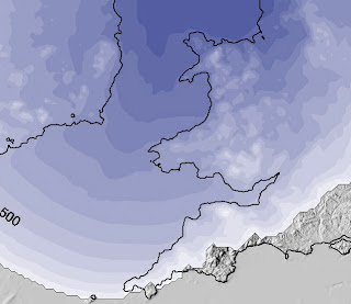
So, to the model:
This is one of the Devensian "maximum" scenarios modelled by Alun Hubbard, Henry Patton and others more than 20 years ago, and it now looks as if it might be rather spookily accurate for the Anglian!! The ice edge incorporates local ice caps on Bodmin Moor, Dartmoor and Exmoor -- and that makes perfect sense, as well as fitting with recent research findings. Ice is shown filling the Somerset Levels depression, and that seems to me to be perfectly logical, since ice coming in from the west must first have filled the depressions in the landscape before thickening to the extent of surmounting escarpments and hill masses. Ice is shown reaching the Salisbury area and covering Salisbury Plain and the North Wessex Downs. Again, I would argue that there is now field evidence from Bristol, Bath, Oxford, the Mendips and the Cotswolds to support this scenario. Moving further east, evidence is emerging for an ice edge at least 40km south of the presumed Anglian limit of earlier researchers.
On balance, therefore, while accepting that we are not always in a position to distinguish between Anglian and earlier glacial episodes, the most likely line for the "Greatest British Glaciation" should run somewhat as shown on the above model -- with Salisbury Plain and the North Wessex Downs (and possibly the Chilterns) submerged beneath thin and possibly cold-based ice. There's the hypothesis -- now it needs to be tested.
I recall you did a Post a good few years ago which mentioned the former existence of some ?erratic? or glacially affected rocks near the A36 and Bath to Portsmouth railway line. I discovered that there is an AONB covering the southern Cotswolds. So I have been intending writing to the offices of that AONB to see if they have an opinion on those pre-existing rock features. Recently there has been a small, quality housing development thereabouts.
ReplyDelete