A recognition of diffluence and diffluent routes is critical in an understanding of glaciated landscapes. In general, glaciers of all sizes will flow in troughs and will tend to straighten them if possible and to deepen them as they seek to discharge as much ice as possible -- as efficiently as possible. A glacier (whether an outlet glacier or a valley glacier) will always flow in a valley or into a lowland in preference to overtopping a ridge or submerging an upland, until the depression is filled to overflowing. But then, if it is offered a col to flow over, it will normally take it, as long as there is no major blockage downstream. In Greenland there are diffluent discharge routes all over the place, including many where we find a rectilinear pattern of troughs. Sometimes, if the ice is able to enter a convenient diffluent discharge route, it may flow towards its own source area, rather than away from it. It gets confusing........... and at one stage of a glaciation the ice may flow one way, and then in the opposite direction at the time of peak glacierisation.
Topographic map of the Kjove Land - Syd Kap area, showing the diffluent trough with its two lakes.
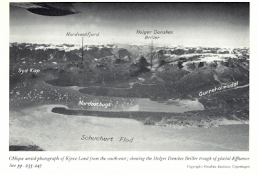
View of the Holger Danskes Briller diffluent trough, seen from the east, across Nordostbugt.
One of the most beautiful diffluent troughs I know is in Kjove Land, East Greenland, where the ice of the Nordvestfjord outlet glacier has spilled over on its left flank just a few kilometres from the trough exit into Hall Bredning. The diffluent trough is now occupied by two elongated lakes which look like a pair of spectacles on a map -- hence the name Holger Danskes Briller.
Annotated satellite image from Bing Maps. Perfect snow conditions for showing up the geomorphological features of importance!
This is from the article published by David Sugden and myself following our 1962 East Greenland expedition. Quote:
The planed surface of the Holger Danskes terminal moraine, an accumulation c. 1 kilometre long and c. 700 metres wide, has an altitude of 101metres (Fig.4). It has kettle-holes in this surface, unsorted moraine on its western flank and shell-bearing mud-banks, sands and gravels on its seaward flank. In view of these characteristics it is improbable that the 101-metre sea level pre-dated or post-dated the formation of the moraine; it seems that the snout of the Holger Danskes glacier was actually depositing this impressive moraine during 101 metre times. Since the Holger Danskes Glacier flowed through a trough of glacial diffluence from the Nordvestfjord Glacier (a major outlet glacier of the Greenland Ice Cap) it is possible that the Kjove Land terminal moraines represent a widespread retreat stage in the East Greenland fjords.
The Raised Marine Features of Kjove Land, East Greenland.
Most of the conclusions from that paper have been confirmed by later research. The big moraine (shown as "Hjornemoraene" on the topographic map) near the south edge of the satellite image marks an important stillstand of the ice at the end of the last glaciation, with an uncertain date; but it does not mark the position of greatest ice extent, since there are many smaller moraines on the hillside above it, above the 200m contour. These have been studied by a number of research teams since 1962, and are probably more than 12,000 years old. The moraines are assumed to belong to the "Milne Land stage" by Svend Funder and later authors. The marine limit in this area is at c 132 m above present sea level, and is dated to c 12,400 yrs BP. In 1962 we identified washes moraine surfaces below this limit, and fresh moraine above it. Some of the moraine ridges around Hjornemoraene are higher up the hillside above the marine limit, and they are therefore older. The big moraine and delta at the exit of the Holger Danskes Briller trough is later, and is dated as around 11,200 yrs BP, coinciding with an important sea-level stillstand during which many shoreline features including delta terraces were formed. These features were the focal points of our research in 1962.
Map from Funder (1972), showing the reconstructed Milne Land stage limits. I don't think these are accurate for the Syd Kap area, since Kjove Land is shown as ice-free, located to the east of the Nordvestfjord Glacier edge. The big moraines at Hjornemoraene are aligned more or less east-west, suggesting to me that the ice tongue in the diffluent trough was confluent with its parent glacier, making the Pythagoras Bjerg upland into a nunatak, surrounded by ice..........
Here is a map from Alexandersson and Håkansson 2014, which shows the mooted positions of the moraines of the Milne Land stage, with an outer limit some way to the east of the Schuchert Valley, I think this must be contemporaneous with the high moraines in Kjove land, emplaced at a time when the Pythagoras Bjerg massif was a nunatak. Date? Maybe around 13,000 yrs BP.......... There is no trace on the satellite image of a prominent moraine ridge on the east side of the Schuchert Valley in the marked position -- but it makes sense for this to have been a floating ice-front, whereas those to the west were grounded ice edges.
References:
Helena Alexanderson & Lena Håkansson (2014) Coastal glaciers advanced onto Jameson Land, East Greenland during the late glacial–early Holocene Milne Land Stade, Polar Research, 33:1, 20313, DOI: 10.3402/polar.v33.20313
https://doi.org/10.3402/polar.v33.20313
Hall, B.L., et al., Relative sea-level changes, Schuchert Dal, East Greenland, with implications for ice..., Quaternary Science Reviews (2010),
doi:10.1016/j.quascirev.2010.03.013


No comments:
Post a Comment
Please leave your message here