THE BOOK
Some of the ideas discussed in this blog are published in my new book called "The Stonehenge Bluestones" -- available by post and through good bookshops everywhere. Bad bookshops might not have it....
To order, click
HERE

Friday, 7 April 2017

Darvill and Wainwright chapter available online


I had not realised it until now, but the big Darvill and Wainwright chapter on the Neolithic and Bronze Age (from the first volume of the Pembs County History) is available online as a PDF.

Here it is:

eprints.bournemouth.ac.uk/26806/1/Darvill%20%26%20Wainwright%202016.pdf

Happy reading! You will need to read it in landscape format, since the PDFs are for double page spreads.

Gallery graves or passage graves?


 Bedd yr Afanc -- not a passage grave, but a gallery grave......


I think it may be wiser to refer to these two features (one at Banc Llwydlos and the other at Penanty-isaf) as potential gallery graves, rather than passage graves.  I'll adjust the titles of the posts accordingly.

According to the big chapter by Darvill and Wainwright in the latest Pembs County History series, Neolithic passage graves were generally chambers covered by substantial mounds with one access passage within.  The passage was just a means of access to the chamber used for burials. They may have had side chambers used for the placing of corpses or bones or cremated remains. Gallery graves, on the other hand, may not have had large covering mounds looking like round barrows or long barrows, although they may have had a complete elongated "roof" made of slabs or capstones. Some are wedge-shaped.  Burials took place in the elongated gallery.

Bedd yr Afanc is classified as a gallery grave, while Cerrig y Gof, near Newport, is classified as a passage grave with a cluster of internal chambers.  Others refer to it as a chambered tomb. (I'm not sure why Darvill and Wainwright (p 92) refer to it as a passage grave, since there was apparently no internal passage.......... but we'll let the experts argue about that....)

It's wise to go with the flow here so as to avoid confusion.  It's clear that the Banc Llwydlos and Penanty-isaf features are nothing like Cerrig y Gof or the other dolmens or portal tombs of west Wales (for example, Carreg Coetan Arthur or Pentre Ifan) -- but they are very similar to Bedd yr Afanc.

Wikipedia definitions:

Passage grave --a prehistoric megalithic burial chamber of a type found chiefly in western Europe, with a passage leading to the exterior. Passage graves were originally covered by a mound, which in many cases has disappeared, and most date from the Neolithic period.

Gallery grave -- an underground megalithic burial chamber which may be divided into sections but has no separate entrance passage.

Thursday, 6 April 2017

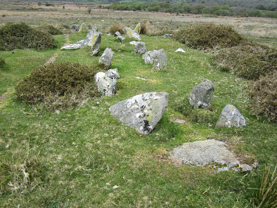
Penanty-isaf gallery grave


This feature is a little more than 1 km from the Banc Llwydlos gallery grave, to the NW and further down the Afon Pennant stream.  It's located on boggy grassland, about 20m from the most prominent hawthorn tree on this part of the common.  Another smaller hawthorn tree is also 20m away.  The boundary of the enclosed land belonging to Penanty-isaf  Farm is about 150m away.

Like the Banc Llwydlos feature, this one is about 12 m long, with a "passage" or "gallery" about 1 m wide.   The alignment of this one is quite different, with a closed end to the NW and the open end to the SE.  About 31 boulders are visible, but here they are not set in prominent ridges -- the ridges are no more than 20 cms high.  Also, the grassy passage is at the same level as the surrounding grassland.  The eastern row of stones appears complete, but the western row is much shorter.   Could it be that this feature was started and never finished?

It certainly looks like a relative of the features at Bedd yr Afanc and Banc Llwydlos, but maybe we should refer to it as a proto-gallery grave, or some such thing.......

Grimes originally interpreted Bedd yr Afac as a wedge-shaped feature like those of southern and eastern Ireland.  Is this one wedge-shaped as well?    Not sure about that..... 

Grid ref:  SN 09560 33896


Banc Llwydlos gallery grave


Thanks to Emyr Jones and others, I was encouraged to go on a gallery grave hunt today, and sure enough I found the one which has been discussed at some length on Facebook and elsewhere.  I'm no expert on gallery graves, but I am convinced -- and I hope that the experts will go and take a look at it..........

The grid reference for this is approx SN 087332 -- it's about 50m NW of the Banc Llwydlos cromlech, and about 100m downslope of the recently burned area.  It is also about 250m from the long fence of the enclosed land belonging to Tafarn y Bwlch.  About 30m to the NW there is a stream gully, but the grave site itself is on dry and grassy land.

The feature is about 12m long, with its open end to the N and its closed end to the S. The "passage" is about 1m wide, and the raised banks are each about 1m wide, revealing many exposed boulders.  The grassy "gallery"  is about 50 cms above the level of the surrounding grassland.  Around 35 boulders are visible in the embankments.  The closed end is about 2.5m wide, and the banks converge towards the open (northern) end.  So there is a wedge shape, as at Bedd yr Afanc.  To the east of the eastern bank there are two large "outlier" boulders -- maybe they are in their natural positions.

Was this feature a real gallery grave, with supported slabs or capstones along its full length?  Maybe -- and maybe these fallen slabs are buried beneath the turf.  Excavation needed!  There are certainly a lot of similarities with Bedd yr Afanc, which is about 2.5 km away.

The site has been investigated by Murphy and Wilson (2012) and is also referred to by Darvill and wainwright on p 93 of the latest Pembrokeshire County History volume.

Postscript - More info

I have discovered this in another excellent Dyfed Archaeology publication:

DYFED ARCHAEOLOGICAL TRUST
REPORT NO. 2012/6  PROJECT RECORD NO. 100689
January 2012
SCHEDULING ENHANCEMENT PROJECT 2011: PREHISTORIC SITES FIELDWORK
– PEMBROKESHIRE ADDITIONAL SITES

Fran Murphy & Hubert Wilson

www.dyfedarchaeology.org.uk/projects/schedulepembroke2011.pdf

Extract for Banc Llywdlos:

PRN 100700 is a possible ‘passage grave or chambered tomb’. It is situated to the east of a stream on a gentle NE facing slope of Banc Llwydlos at 260m above sea level. The stone setting is aligned roughly N-S and is widest at its southern end where the stones appear to form a 'chamber' up to which a narrow linear 'passage' runs from the entrance at the northern end. It is very similar in construction to the scheduled ancient monument Bedd yr afanc chambered tomb that lies just over 2.5km to the northeast (PRN 1032, SAM PE122), and in the same topographical position on the edge of boggy ground.
The site was recorded by P Drewett in 1984 as a ’multiple stone setting/passage grave’ but had not been recorded on the HER before now.

Here is the plan drawn up by Murphy and Wilson:


Here is the map of the area, as published in the Report:


Note that Murphy and Wilson refer to PRN 100700 as a ‘passage grave or chambered tomb’ -- it's clear that there are considerable differences over terminology!

Note also that 4 features are shown very close together around position PRN 100700 -- the Banc Llwydlos "cromlech" is one of these.

Banc Llwydlos cromlech (1)


I wonder how many undiscovered cromlechs there are in Pembrokeshire?  Not many, I suppose.  Anyway, I found one of them today, while hunting for Neolithic passage graves on Brynberian Moor.  I have checked, and can find no record of it on Coflein, Archwilio or any of the other sites.  If somebody knows about it already, please get in touch, so that we can share info.......

I imagine that at the height of summer, the nettles and rushes will be much higher, making this capstone quite difficult to spot from a distance.

It's rather a nice little cromlech, located on a slight morainic ridge of dolerite boulders, some of which are up to 5m long, and deeply embedded in the ground.  Grid reference SN 088332.    I didn't have time to survey it accurately, but it is an "earthfast dolmen" with a flattish capstone about 2.5m long, with one end embedded in the ground and the other propped up in rather a complex fashion,  resting partly on a dish-shaped slab of dolerite about 1.5m long and partly on a smaller stone with dimensions 30 cm x 10 cm x 10 cm.  I think that is too complex an arrangement to have occurred by chance in a glacial environment -- so my conclusion is that the big slab has been used where found, with one end levered up (probably with the aid of long logs) and then supported by these two stones.   There are actually other smaller stones supporting the larger of the two supports.  

The capstone is about 60 cms thick at the earthfast end, and about 30 cms thick at its propped end.  The "entrance" or propped end of the chamber points roughly northwards. 

It is possible that in the past human beings could have crawled beneath the capstone into a chamber which is currently demarcated by an almost circular ridge or embankment.  This latter feature cannot be natural either -- it is perfectly obvious when you scramble around on it. 

The embankment is about a metre high, with many large stones projecting through the turf.  Again, big erratics have been used where found, with smaller stones packed between them.  The hollow adjacent to the capstone is very clear too.  The diameter of the whole embanked structure is about 6m. 

Was there a mound with a chamber beneath it?  It's possible.  My impression is that this is a very primitive feature (Early Neolithic?) built opportunistically in a place where all the stones needed were available on the spot.  All of the stones are dolerite, except for a small slab of mudstone which is found in the "entrance" to the tomb -- could it have been a portal or movable doorway?

The only other record that we have for Banc Llwydlos is this one, from Dyfed Archaeological Trust, relating to a cluster of huts not far away.  Are the features all related?

I'll do another post on the assumed "passage grave" (about 50m away) which I also had the opportunity to examine today.........


=======================


DYFED ARCHAEOLOGICAL TRUST
PROJECT RECORD NO. 96851
March 2010
SCHEDULING ENHANCEMENT PROJECT 2010: PREHISTORIC SITES FIELDWORK – PEMBROKESHIRE
By F. Murphy, M. Page, R. Ramsey and H. Wilson

PRN 14373 NAME BANC LLWYDLOS TYPE UNENCLOSED SETTLEMENT PERIOD Prehistoric NGR SN08973303

CONDITION Damaged

STATUS NPP

FORM Earthwork complex

SUMMARY A settlement complex including at least seven hut circles surrounding a square enclosure and yard, situated on the northeast facing slope of Banc Llwydlos.

LONG DESCRIPTION A settlement complex including at least seven hut circles surrounding a square enclosure and yard, situated on the northeast facing slope of Banc Llwydlos at 270m above sea level. Indentified from aerial photography in 1990, 2009 saw the first site visit and this recorded a settlement complex of possible prehistoric date. The complex includes seven hut circles that are spread around a small square shaped enclosure. The square enclosure measures approximately 6.0m E-W by 5.0m and has an entrance on the north. The
entrance leads out to a small 'yard' area that has an opening on the east into a larger rectangular 'yard' area measuring 18m E-W by c.6.0m. These yards appear to have been constructed on a platform to create a level area on the sloping ground, and much of the settlement has the appearance of being somewhat terraced into the hill slope. The hut circles vary from 5.5m to 3.5m in diameter. All the features are defined by low, spread, stony earthen banks that have an average height of 0.3m and an average width of 1.3m. All the banks are grass covered and many have large stones protruding through the turf. 350m to the east is another hut circle group PRN 1565 that has been scheduled. FM & RR June 2009
A stone banked series of features including one or more possible huts with linking walls. Noted by CRM during air survey. TAJ 21:2:1990.




The great passage grave hunt


Passage graves?   Photos:  courtesy Emyr Jones


Following a mention in one of the local archaeology newsletters, there has been a flurry of activity here in North Pembrokeshire as people of all ages and levels of expertise go off hunting for passage graves on Brynberian Moor.  I was alerted to this by Emyr Jones, who has stimulated a lot of discussion on social media.

The approx grid references for the features found by Emyr and his friends are SN 095338 and SN 087332.  One of the features is near a prominent hawthorn tree on the moor, and the other is not far from the edge of a recently burnt area.

This is a part of the moor which is not visited very often, lying on the flank of the great moraine which I have described in earlier posts in the vicinity of Tafarn y Bwlch.  On the OS map the area is referred to as Banc Llwydlos.

I shall go and take a look, and report back......


Above is a Google earth image of the Banc Llwydlos area -- a big and boggy wilderness area of several sq km with extensive tracts of gorse, bracken and wetland.  Needle in haystack territory -- but this is the best time of year to go searching, before the bracken gets high.

On the image above Tafarn y Bwlch is on the extreme left, and the big farm is Penanty-isaf.  The stream catchment is that of the Afon Pennant, which flows down towards Brynberian vallage and the Brynberian river gorge.


Tuesday, 4 April 2017

The creation of the Straits of Dover


 https://www.researchgate.net/blog/post/britain-would-still-be-attached-to-europe-had-this-ridge-remained-intact


This is an interesting article -- I have not yet managed to read the original in "Nature Communications".  The idea of the Ice Age megaflood draining a pro-glacial lake in the southern North Sea is an old one, and Gupta and his colleagues have been reporting on the essentials of this work for more than 10 years now.  What is new is the linking of the megaflood event with the gigantic depressions (up to 100m deep) close to the position of the old chalk ridge that ran across from one side to the other.  They are now interpreted as plunge pools created by enormous volumes of meltwater cascading over the low points in the ridge.

On the illustration above, note the herd of rhinos..... nice touch!

It looks as if the original breach of this chalk ridge is now assumed to have occurred at the end of the Anglian Glaciation, around 500,000 years ago.   We have talked rather a lot about that particular glaciation on this blog.......

It's always good to see some serious glacial geomorphology given some publicity by the BBC and other media -- but calling the "megaflood event" an Ice Age Brexit really is taking things a bit far.  Has the whole world gone bonkers?  Well, yes........