"Oh dear -- this gets REALLY confusing. Why don't we just fill the bloody hole in again and forget about those blasted stumps?" By the way, they are stumps 32d (spotted dolerite, in the foreground) and 32e (rhyolite, to the left) ......
I have been convinced for some time that there are well over 30 different sources for the bluestones in the Stonehenge area. Been looking through the records, and here is a starting list. It's a difficult list to compile, because many identifications are from visual examinations only, while others are from detailed petrography and geochemistry (methods used by the OU team in the late 1980's), and yet more through detailed analysis by Dr Rob Ixer, Dr Richard Bevins and others, using the latest methods, in the last few years. Geological names also change over time, and (for example) what used to be called rhyolite now has many different names. Some provenances are known (where stone numbers are given) but there are literally thousands of smaller stones and fragments in the various collections -- and it is not impossible that some of these samples have been given different names and maybe different numbers, leading to duplication. Even the numbering of stones is not consistent.
Here is a list for starters -- thanks are due to Dr Rob Ixer for keeping me informed of progress on the geology of the Stonehenge finds. I have listed some of his publications on previous posts. I'll welcome corrections, since there are bound to be mistakes. But I wouldn't mind betting that when this list is corrected it will get even longer, since stones currently grouped together (for example the white spotted dolerites and the pink spotted dolerites) may well prove to incorporate stones from different provenances.
On the other hand there is considerable geological variation on the rocky outcrops of Preseli and along the exposures of Fishguard Volcanics -- so for example a dolerite and a rhyolite may occur right next to one another on a single tor.
Note -- not all of the Stonehenge monoliths are listed below -- many stones have not been examined and still have to be categorized, especially those from within the spotted dolerite and unspotted dolerite groups.
Stonehenge Bluestone Types
1. Unspotted dolerite ---- monoliths 45 and 62. Carn Ddafad-las?
2, Spotted dolerite -- densely spotted. Monolith 42 -- Carnbreseb? 43?
3. Boles Barrow dolerite -- spotted? But similar to stones 44 and 45? From Carnmeini / Carngyfrwy area?
4. Rhyolite -- stones 38, 40, ignimbrite character. Ash-flow tuffs (dacitic). Not Carnalw ? May be from different sources?
5. Rhyolite -- stones 46 and 48, rhyolitic ash-flow tuffs. Carnalw area? Same source?
6. Rhyolite fragment from a different source from the above types
7. Laminated calcareous ash -- stumps 40c, 33f, 41d
8. Altered volcanic ash -- stump 32c, 33e?
9. Rhyolite -- another type -- stump 32e. Related to Pont Saeson samples?
10. Micaceous sandstone -- stumps 42c, 40g (Palaeozoic -- South Wales origin?)
11. Rhyolite -- lava -- stone 46
12. Rhyolite -- flinty blue -- different lava? stone 48
13. Spotted dolerite with whitish spots --stones 33, 65, 68, stump 70a?, stump 71?, 72
14. Spotted dolerite with few spots -- stone 31, 66?
15. Spotted dolerite with pinkish spots -- stones 150, 32, 34, 35A, 35B (one stone), 39 (?), 47, 49, 64, 67, 69, 70
16. Spotted dolerite -- moderate spots -- stone 37, 61, 61a?
17. Unspotted dolerite -- stone 44 -- different from stones 45 and 62
18. Very fine-grained unspotted dolerite -- stone 62
19. Silurian sandstone -- Cursus -- fragments
20. Devonian sandstone -- Altar Stone -- Devonian Senni Beds -- Carmarthenshire or Powys
21. Sarsen sandstones -- various types -- packing stones and mauls
22. Jurassic oolitic ragstone -- Chilmark?
23. Jurassic glauconitic sandstone -- Upper Greensand?
24. Gritstone unspecified fragments (Maskelyne, Judd)
25. Quartzite unspecified fragments (Maskelyne, Judd)
26. Greywacke unspecified fragments (Maskelyne, Judd)
27. Granidiorite -- Amesbury long barrow 39
28. Quartz diorite -- ditto
29. Hornblende diorite -- ditto
30 Flinty rhyolite -- fragments from Pont Saeson
31. Rhyolite fragments -- with titanite-albite intergrowths (source unknown)
How much do we know about Stonehenge? Less than we think. And what has Stonehenge got to do with the Ice Age? More than we might think. This blog is mostly devoted to the problems of where the Stonehenge bluestones came from, and how they got from their source areas to the monument. Now and then I will muse on related Stonehenge topics which have an Ice Age dimension...
THE BOOK
Some of the ideas discussed in this blog are published in my new book called "The Stonehenge Bluestones" -- available by post and through good bookshops everywhere. Bad bookshops might not have it....
To order, click HERE
Some of the ideas discussed in this blog are published in my new book called "The Stonehenge Bluestones" -- available by post and through good bookshops everywhere. Bad bookshops might not have it....
To order, click HERE
Tuesday, 9 November 2010
More on small glaciers
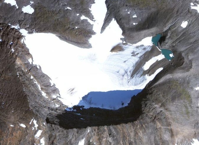
As part of my ongoing attempt to spread knowledge about glaciers, and how they behave, here are two fantastic images from Google Earth. The one below shows an amazing and near-perfect cwm or cirque (or corrie, if you insist on English) on the north-facing edge of a basalt plateau neat Isafjordur, NW Iceland. Click on it and you can even see the little moraine that shows the glacier terminus position -- probably during the Younger Dryas cold episode around 10,500 years ago.
The other photo is from North Norway, and it shows a small cirque glacier (aligned broadly NE) typical of many in the uplands -- if you click on it you can see the blue ice near the snout, and even the morainic debris within the glacier. The small glacier that occupied the cwm near Foelcwncerwyn probably looked something like this.
Monday, 8 November 2010
The Preseli Ice Cap (2)
The Preseli Ice Cap might have looked something like this -- this is Drangajokull in NW Iceland. Click to enlarge. This ice cap is very thin and rather inactive today -- in many places you can see the bedrock coming through the ice surface. With climate warming, it's wasting very rapidly, and may be gone within decades. There is one major difference with the Preseli Ice Cap -- this one has had a number of quite substantial outlet glaciers which have been capable of dramatic glacial erosion -- in particular Kaldalon, which runs down towards the bottom left corner of the photo. Ah -- happy days -- I was there in 1960. My first serious encounter with a glacial landscape.
The Preseli Ice Cap
The only cwm on the Preseli uplands, eroded over many glacial episodes by a small cirque glacier.
Was there a Preseli Ice Cap during the Ice Age? Almost certainly, yes -- on a number of occasions, at the beginning and end of each glacial episode. This is exactly what we would expect in a location some way removed from the main ice centres but which would probably have had adequate precipitation to create a permanent thin ice cover while the big ice caps were waxing and waning over the Cambrian Mountains, over Ireland and in the Irish Sea area. I got thinking about this from having a glimpse of the latest computer models of the Devensian glacial episode, from Aberystwyth University.
The only trace of a moraine which can be termed "local" is in the cwm to the east of Foelcwmcerwyn, the highest summit on Preseli -- at 536 m. There is a rather indistinct ridge made of till, down in the valley beneath the old slate quarry and dissected by stream action. I have always thought that this feature dates from the last small glacier on Preseli -- tucked away on the shady lee side of the summit, where snow could accumulate and survive and be converted into ice. The glacier will have been a small cirque glacier, capable of a modest amount of erosion. When? Probably Younger Dryas or Zone 3, when there were also small glaciers in many of the Welsh uplands. But prior to that, the glacier will have existed in exactly this spot many times before, in earlier glaciations.
When the Preseli ridge was covered by its little ice cap, I don't think it was ever active enough to affect the landscape through the carving of erosional features, or through the transport of eroded debris downslope. In other words, there may not have been sufficient ice thickness for the ice to FLOW (except in the cwm) -- it may have remained frozen to its bed, and may therefore have had a largely protective role.
Was there a Preseli Ice Cap during the Ice Age? Almost certainly, yes -- on a number of occasions, at the beginning and end of each glacial episode. This is exactly what we would expect in a location some way removed from the main ice centres but which would probably have had adequate precipitation to create a permanent thin ice cover while the big ice caps were waxing and waning over the Cambrian Mountains, over Ireland and in the Irish Sea area. I got thinking about this from having a glimpse of the latest computer models of the Devensian glacial episode, from Aberystwyth University.
The only trace of a moraine which can be termed "local" is in the cwm to the east of Foelcwmcerwyn, the highest summit on Preseli -- at 536 m. There is a rather indistinct ridge made of till, down in the valley beneath the old slate quarry and dissected by stream action. I have always thought that this feature dates from the last small glacier on Preseli -- tucked away on the shady lee side of the summit, where snow could accumulate and survive and be converted into ice. The glacier will have been a small cirque glacier, capable of a modest amount of erosion. When? Probably Younger Dryas or Zone 3, when there were also small glaciers in many of the Welsh uplands. But prior to that, the glacier will have existed in exactly this spot many times before, in earlier glaciations.
When the Preseli ridge was covered by its little ice cap, I don't think it was ever active enough to affect the landscape through the carving of erosional features, or through the transport of eroded debris downslope. In other words, there may not have been sufficient ice thickness for the ice to FLOW (except in the cwm) -- it may have remained frozen to its bed, and may therefore have had a largely protective role.
The Stonehenge bluestone sources -- 24 and still counting?
Igneous outcrop at Pontsaeson near Brynberian, one of the recently identified bluestone sources
To continue:
After counting the 15 or so bluestones and fragments so far mentioned, we have abundant packing stones and mauls that are often conveniently forgotten about -- but there are massive quantities of them, some as large as 60 kg in weight. There isn't much geology on these -- but we know that there are small sarsens, and also Jurassic oolitic limestones and glauconitic sandstone, probably from the fringes of Salisbury plain.
At least 18 rock types, and still counting.
Then we have the famous Altar Stone, probably from the Senni Beds of Carmarthenshire or Powys, and other fragments of volcanic ashes (two distinct types), Preselite (a term which is almost as vague as "bluestone") and sandstones.
What we still don't know, until this is sorted out by the geologists, is how much repetition of rock types there is in the listing above. The provenancing of finds from the Stonehenge Layer at Stonehenge and from the other sites near the Cursus and at "Bluestonehenge" may ADD to the list above, or some identifications may replace earlier crude identifications made without the benefit of modern techniques. Rob Ixer, Richard Bevins and others are working on this right now, and their discovery of rocks from Pont Saeson and other sites north of the Preseli Hills is highly intriguing.
My guess is that we are now up to 24 different rock types, and still counting. I wouldn't mind a small bet that the total number of sources will reach 30 before long. There is no reason at all, in an assemblage of glacial erratics or in an ancient and degraded till deposit, to find even more rock types from the north and west.
Bluestone Rock Types -- 15 and counting
A short extract from "The Bluestone Enigma":
It was Herbert Thomas who speculated on a Preseli origin for the Stonehenge bluestones in 1908 and then went on to propose, in his famous 1921 lecture, that the bluestones were identical to rocks cropping out within one small area around Carn Meini. These bluestones, located within the bluestone circle and the bluestone horseshoe, comprise 43 stones, give or take a few. The best estimate is that there are 27 spotted dolerites (including at least two that are broken in half), three unspotted dolerites, five altered volcanic ashes, five rhyolites (of which two are ignimbrites and two are lavas), two micaceous sandstones and a greenish sandstone called the Altar Stone. The spotted dolerites are more variable than one might think; some of them have obvious and large spots of whitish or pinkish feldspar, and others have spots that are almost too small to see with the naked eye. The two micaceous sandstones and five volcanic ashes are just left as stumps, buried beneath the turf.
Most people believe that Herbert Thomas actually sampled the bluestones in the stone settings at Stonehenge. He did not do that. Instead, his work was based upon a visual examination of 34 in situ stones and an analysis of fragments and samples from assorted collections made by William Cunnington, Nevil Maskelyne and William Judd. His analytical method was called “standard transmitted light petrography” which involved a detailed examination of thin sections made from his samples. He also looked at thin sections made from samples taken from the tors in the Preseli Hills, although it is unclear whether any of the samples were his own. Again he seems to have depended largely upon samples collected by other geologists. Some of the samples came from bluestone fragments found in the soil during excavations.
So if we look at the main bluestones at Stonehenge (the standing stones or orthostats, and the stumps below ground) and ask how many localities they have come from, we immediately have problems. This is partly to do with the variation in the dolerite and rhyolite groups -- we cannot assume that the spotted dolerites have all come from Carn Meini (it seems that Carn Goedog is a better bet if we want to look at a single locality) because there are many degrees of spottiness both within individual outcrops and within the Stonehenge bluestone assemblage.
The OU team that worked on the Stonehenge bluestones in the late 1980's concluded that out of the 39 samples they analysed, there were at least 3 distinct dolerite sources, and 7 different rhyolite sources. Then there were also 2 micaceous sandstone sources and a number of volcanic ash sources. That suggests about 15 sources in total -- and we are still counting. Watch this space....... I'll put up another post shortly.
Saturday, 6 November 2010
Bothersome Bluestones
Time for a recap. Below is a short article which I wrote for the Western Mail a few years ago. Nothing has changed, except that the geologists have come up with a number of new sources or provenances for the "litter" of foreign stones in the Stonehenge district. Some of the litter doesn't seem to have come from big stones at all, but from smaller fragments. So glaciation looks more and more likely, and human transport less and less likely.
It strikes me as increasingly bizarre that the mere presence of foreign or erratic stones at Stonehenge is taken by most archaeologists as EVIDENCE of human transport and of some great purpose lying behind the use of the stones. For me, as a geomorphologist, I take the physical presence of the stones as EVIDENCE (not PROOF -- that would be too strong a word) of glacial transport. When people ask me where the hard evidence of glacial transport is, I say that it is right there, for them to look at -- in the assemblage of the things called "bluestones." So then they say "No no, that's not evidence! Find us some moraines and deposits of till, and erratics dotted all over the place!"
Just be patient, you guys....... that's not how glaciers work. I suspect we won't find loads of erratics or moraines, but we might well find very old till here and there, related to the ancient glacial deposits we already know about on the Somerset Levels and near Bath.
And the archaeologists, in their wild fantasies, conveniently forget that there is NO evidence of any kind in support of the human transport theory. No quarries, no tracks, no rafts, no rollers, no boats, no lost stones. Zilch. Zero. No precedents, no parallels or equivalents from anywhere else in Neolithic or Bronze Age history. Just a blind faith in the supposedly powerful motivations and technical brilliance of our shadowy ancestors. Oh dear oh dear.
---------------------------------------
Those Bothersome Bluestones......
The strange link between Mynydd Preseli and Stonehenge has been discussed enthusiastically by archaeologists for exactly one hundred years. It was in 1908 that the Welsh geologist Herbert Thomas first suggested that the bluestones of Stonehenge might have originated in the uplands of Pembrokeshire, and by 1921 he had completed the research that confirmed his earlier speculation.
One might have expected that Thomas, as a geologist, would have found a natural explanation for the transport of the stones. It was already known that the great Irish Sea Glacier had crossed Pembrokeshire during the Ice Age, and that it had flowed up the Bristol Channel from west to east. One or two geologists had already suggested that the bluestones were glacial erratics. But Thomas blithely dismissed the glacial transport theory as “untenable” and went on to develop an extraordinary tale of Neolithic tribesmen collecting the stones from Preseli and transporting them by land all the way to Salisbury Plain for incorporation into the Stonehenge monument.
In spite of the fact that Thomas’s theory had no evidence to support it, it was not questioned by other scientists, and to this day it has gone largely unchallenged. On the contrary, it has been accepted by generations of archaeologists as fact, even though there is still not a shred of evidence to show that the great “stone collecting expedition” ever happened. Within recent decades one or two geologists have had the temerity to argue in favour of the glacial theory, but they have been immediately vilified by the archaeology establishment.
Because the theory of human transport has never had to cope with facts (convenient or inconvenient) it has been embellished to a ludicrous degree, most recently by Professors Wainwright and Darvill, who have proposed that the bluestones were revered in Preseli for their supposed healing properties, and that this explains why they were collected and carried off to a sort of Neolithic hospital at Stonehenge. This idea has no facts to support it either, and fellow archaeologists have accused the two learned professors of being “out with the fairies.”
It’s time to bring this increasingly bizarre debate down to earth. Let’s look at a few facts. The two professors have claimed that all of the bluestones have come from a small area around a spotted dolerite crag called Carn Menyn, where there was a bluestone quarry. There is no quarry there, and the stones are now known (from work by an OU geology team) to have come from around 20 different sources scattered all over West and South Wales. It’s claimed that the Altar Stone at Stonehenge came from Cosheston on the shore of Milford Haven; but it’s now known that it came from somewhere in Carmarthenshire or Powys. It’s claimed that the spotted dolerite of Preseli was revered for its magical properties; in fact, it was never used preferentially in cromlechs or standing stone settings in Pembrokeshire or anywhere else. The professors say that there were abundant healing springs in the area around Carn Menyn, used by local people until quite recent times; in fact, there are no local traditions which tell of any “special properties” in the local water supply. We could go on and on..........
And while the archaeologists have been seeking -- with singular lack of success -- to portray their human transport fantasy as the truth, the geologists have quietly been getting on with their work. It is now known that the Irish Sea Glacier did not simply flow up the Bristol Channel, but that it reached as far east as Street in Somerset, the Mendips and the city of Bath. The 43 bluestones at Stonehenge can only be an assemblage of glacial erratics, left by the wasting ice somewhere to the west of Stonehenge. New computer modelling of the Irish Sea Glacier by Dr Alun Hubbard and colleagues at Aberystwyth University shows that at the time of its greatest extent, it probably flowed across Salisbury Plain.
Subscribe to:
Posts (Atom)