THE BOOK
Some of the ideas discussed in this blog are published in my new book called "The Stonehenge Bluestones" -- available by post and through good bookshops everywhere. Bad bookshops might not have it....
To order, click
HERE

Saturday, 25 August 2018

The Carn Goedog Files


These are the four assessments which I have made of the recent paper by Parker  Pearson et al which is published in "Antiquity" journal.

https://brian-mountainman.blogspot.com/2018/08/more-from-megalithic-quarrymen.html
https://brian-mountainman.blogspot.com/2018/08/more-from-megalithic-quarrymen-2.html
https://brian-mountainman.blogspot.com/2018/08/more-from-megalithic-quarrymen-3.html
https://brian-mountainman.blogspot.com/2018/08/more-from-megalithic-quarrymen-4.html

The paper itself:

"Megalith quarries for Stonehenge’s bluestones", by Mike Parker Pearson, Josh Pollard, Colin Richards, Kate Welham, Chris Casswell, Duncan Schlee, Dave Shaw, Ellen Simmons, Adam Stanford, Richard Bevins & Rob Ixer. Antiquity 2018, issued as a pre-publication PDF by Southampton University (not in final format)

https://eprints.soton.ac.uk/421631/1/Megalith_quarries_Antiquity_REVISED.pdf

I have made many other comments on the Carn Goedog research over the past few years -- use the search facility on this blog to find them.

This paper is so seriously defective, in almost every respect, that I find it bizarre that it ever found its way into an academic journal published by Cambridge University Press.  It is not a research paper; it is piece of unabashed marketing.   I have asked this before, and I ask it again -- where is the scrutiny from within the archaeological establishment?  How is it that so many serious and senior archaeologists -- and two senior geologists -- have allowed their names to be attached to it as co-authors?

And the most serious issue of all.  If I, as a local person with a detailed knowledge of this site and with an academic background, had not been around at this moment in history, and had not been able or willing to look at the excavation site and to scrutinise the research output from the MPP team, everything in this article would have been accepted as THE TRUTH.  Just think about it..........

And think about this.  If this is the level of non-scrutiny applied to Rhosyfelin and Carn Goedog, how many other British archaeological sites are there which have been wildly misinterpreted and which have had  nonsensical narratives attached to them?

Rhetorical questions, I know.  But sometimes they are needed.  Actually, rhetorical questions don't need answers.  Maybe these questions do. 

There are plenty of sensible archaeologists around.  But when are they going to speak up?  Quite seriously, if they do not, archaeology will become a standing joke.

Friday, 24 August 2018

More from the Megalithic Quarrymen (4)


This is the paper:

"Megalith quarries for Stonehenge’s bluestones", by Mike Parker Pearson, Josh Pollard, Colin Richards, Kate Welham, Chris Casswell, Duncan Schlee, Dave Shaw, Ellen Simmons, Adam Stanford, Richard Bevins & Rob Ixer. Antiquity, June 2018 .

https://eprints.soton.ac.uk/421631/1/Megalith_quarries_Antiquity_REVISED.pdf

The last two sections of the paper are entitled "Megalith-quarrying at Carn Goedog and Craig Rhos-y-felin" and "From the bluestone quarries to Stonehenge" .  These are the sections that would be called -- in a conventional academic paper --'"Interpretation" and "Discussion".    But this is no ordinary paper, and as as we have seen, the authors see no merit at all in presenting their evidence and considering any alternative explanations for the features described.  So with a degree of certainty which we continue to find  quite amazing,  they simply continue with their narrative.........

And it gets ever more convoluted and confusing, with more radiocarbon dates thrown into the mix.  Rhosyfelin is also brought into the narrative, with some dates previously unreported.

The authors start by saying:   "At least five bluestone pillars (Stones 33, 37, 49, 65 & 67) were taken from Carn Goedog, and probably many more (Bevins et al. 2013). The multiple and large recesses in the rock face are further evidence that pillar removal was extensive at this outcrop....."   I don't recall Bevins et al saying that  at least five bluestone pillars (with numbered identities) came from here;  their paper was much more circumspect,  and as I have pointed out many times, they did not demonstrate that any spotted dolerite bluestones actually came from the tor rather than from other places along the sill that extends towards Carn Alw.  But one doesn't want the truth to get in the way of a good story, does one?


As for Rhosyfelin, there is a change of tone.  In this article the authors claim that "at least one pillar" came from here, and maybe one or two more.  That claim is still, of course, completely speculative, and is unsupported by any evidence, as my two colleagues and I demonstrated in 2015.

The authors claim that "artificial platforms" were constructed at both of their putative quarrying sites, and that at Rhosyfelin there was a vertical drystone retaining wall at the platform edge. We have looked at this before, and have shown it to be entirely fanciful.  Equally fanciful is the "hollow way" cut into soft riverine sediment.  New radiocarbon dates of 4434 yrs BP, 4404 yrs BP and 4627 yrs BP have been obtained for charcoal fragments in the alluvium resting in the "hollow way".  Parker Pearson et al argue, on this basis, that the hollow way had gone out of use by this time;  but if you consider (as I do) that the hollow way is simply the product of a fertile imagination, the dates simply indicate that during the aggradation or accumulation of sediments on the valley floor there was possibly burning and forest clearance somewhere upstream.   That would not have been surprising, in an area full of Neolithic and Bronze Age settlement traces.  A so-called rhyolite end-scraper was found in the sediment fill on the platform, with two radiocarbon dates of around 6,000 yrs BP;  these are extremely inconvenient, and are therefore classified as being "residual in redeposited material".  Ah, if in doubt about something, call it a ritual feature, and if a date is wrong, call it residual........

In seeking to demonstrate a common history for Rhosyfelin and Carn Goedog, the authors do not make a very good fist of it.  They confuse the issue by using phrases like "the second half of the fourth millennium BC", but essentially they are saying that most of the prehistoric dates for Carn Goedog fall within the period 3350 - 3000 cal BC or 4500 - 4300 yrs BP.  But their own table of dates shows that only five or six dates fall into this period, whereas about twenty do not!  Just as we argued at Rhosyfelin, there is absolutely no reason to connect any of these dates with quarrying activity, and the only way for any reasonable person to interpret them is to say that there was a long history of intermittent occupation by hunters and gatherers -- just as there was at Rhosyfelin.  The authors argue that there was a "slightly longer chronological span" at Rhosyfelin.  Who are they trying to kid?  Their dates show that the site was occupied, off and on, between the Mesolithic and the Iron Age,  with a time span of 6,000 years or more......

There is then an attempt by the authors to match up their perceived "peak quarrying period" with the age of cremated human bone in Aubrey Hole 32, and they repeat the assertion that the holes held bluestones. But as we know, no sound evidence has ever been produced that there was any link at all between the bluestones and the Aubrey Holes.  As ever, we are solidly into the realms of fantasy.

Then to the final section called "From the bluestone quarries to Stonehenge".  This is all speculation and no evidence.  At the outset, the authors refer to "the stone-dragging teams"and the various routes they might have followed.  Then they seek to make a link with Banc Du -- broadly early Neolithic, broadly coincident with the supposed placing of bluestones in the Aubrey Holes, and broadly coinciding with (so they say) the end of megalith quarrying at Carn Goedog.   The trouble is that no connection is established between any of these,  and we could equally well say that everything that happened broadly in the early Neolithic in the British Isles was connected to everything else, as part of a cunning plan.

Banc Du is considered as a possible "stopping place for the bluestones" and as a place where a sort of proto-Stonehenge might have been erected.  But that is considered unlikely, and the latest favourite is Waun Mawn, as we all know, even though Prof Grimes thought it unlikely that there ever was a stone circle here. MPP and his colleagues love the fact that Waun Mawn is only (so they say) 3 km from Carn Goedog, 3km from Rhosyfelin, 2 km from Cerrigmarchogion, and (so they say) 3 km from Banc Du.  A perfect location!  They will soon turn up and will dig it all up.  Watch this space.

-----------------------

My final thoughts about this paper?   Well, I thought that the 2015 paper on Rhosyfelin was one of the worst papers I had ever read.  This one is even worse. It is a mish-mash of assertions, and very little of what the authors say is actually supported by their own cited evidence or by their own radiocarbon dates.


Just a reminder -- this is from the Rhosyfelin dig.  The archaeologists refer to this as "vertical drystone walling and revetment at the edge of the loading platform..."  They apparently expect us to believe this.

More from the Megalithic Quarrymen (3)


Herewith chapter 3 of my scrutiny of the latest paper from the quarrymen, which deals (mostly) with Carn Goedog, which has previously gone unreported in peer-reviewed journals.  Lots of mentions in glossy popular magazines, but after three seasons of digging (2014, 2015 and 206) there have been no field reports or annual updates -- just lots of assertions, photos and diagrams which give the impression, as ever, that everything is sorted and that there are no doubts about anything.........

This is the paper:
"Megalith quarries for Stonehenge’s bluestones", by Mike Parker Pearson, Josh Pollard, Colin Richards, Kate Welham, Chris Casswell, Duncan Schlee, Dave Shaw, Ellen Simmons, Adam Stanford, Richard Bevins & Rob Ixer. Antiquity, June 2018 .

https://eprints.soton.ac.uk/421631/1/Megalith_quarries_Antiquity_REVISED.pdf

So we come to tools and quarrying techniques.  It's worth quoting this in full:

"...........the only surviving artefacts are of stone. These include a large number of coarse stone tools, a handful of quartz flakes and a single flint blade. The most common of the coarse stone tools are implements with wedge-shaped profiles (n=15), generally with a wide ‘blade’ at one end and a narrow, thick terminal at the other end (Figure 8). These exhibit numerous flake scars along the blade, along one or both sides of the implement. Some also have traces of battering on their thick ends. There are also occasional scars running between the blade and the thick end.
These wedge-sectioned coarse stone tools are interpreted as wedges, for opening up the joints between each naturally formed pillar so that it could be levered away from the outcrop. These tools are all of mudstone or sandstone, not the locally occurring dolerite, which raises the possibility that they were used because of their softness in relation to the spotted dolerite. One reason for this may be that the forces created by driving in soft stone wedges would not have caused fractures within the dolerite that might have weakened the pillar. Any fracturing would have been confined to the soft wedges and not to the monoliths."

Excuse me, gentle reader, but I really am trying to be polite here.  Have I got this right?  The quarrymen are saying that our Neolithic ancestors used soft shale and sandstone "wedges" which were hammered into cracks or joints in the spotted dolerite rockface to assist in the extraction of monoliths, and that the wedges needed to be soft so that they could be sacrificed without causing fractures in the dolerite?  What sort of fantasy world do these people exist in? If you have got metal wedges, that's fine; you might use them in the knowledge that some might be lost if a joint or fracture does not open up as expected, but they might just work.  But we are talking here about the Neolithic, not the Iron Age.  Wooden wedges might work too, if you hammer them in dry and then let them expand as they get wet.  But to use soft and flaky shale as wedges in spotted dolerite bedrock?  No, no, no.........

And what of the evidence that these wedge-shaped bits and pieces are really "implements" or engineering accessories?  Flake scars?  Battering traces?  Scars running from one end to the other?  We need to see the colour of the evidence, and all we have is this -- Figure 8:


Figure 8. Stone wedges and a hammerstone (bottom left) from Neolithic contexts at Carn Goedog (drawn by Irene de Luis).  

Note:  what are "Neolithic contexts"?  That's a nice little throwaway phrase, designed to cement the thesis.  But it is meaningless.  It probably simply means that these bits and pieces were found among the rocks and in the sediments at Carn Goedog.............

As far as I am concerned, bits and pieces of shale, mudstone and sandstone that look like these featured fragments litter the north Pembrokeshire landscape.  I found some lovely elongated and wedge-shaped pieces of shale, complete with facets (or shall we call them flake scars?) in the stream at the bottom of our garden, just the other day.  No attempt is made to show us that these fragments are special in any way -- we are just told that they are.  Not good enough.  In my view, this is just another example of the researchers being desperate to find something that can have been fashioned by human beings -- this will do, they reckon, and we are expected to believe them......

Then there is reference to "a handaxe-like implement with battering along its edges. Such a tool could have been used to open up narrow joints, by widening the sides of the joint sufficiently for a wedge to be then inserted and driven in."  We are not shown this so-called implement, but we are shown (in Figure 9) an apparently widened or broken joint  which could be very old or very new, or anything in between.  It could be natural and it could be man-made -- and we have no idea how unique or unusual it is. The authors tell us that they have seen two such features at Carn Goedog -- but they have not checked to see whether similar features occur on all of the other spotted dolerite tors in this part of Preseli.   As ever, their assumptions of uniqueness and significance are unaccompanied by any studies of control sites with which comparisons could be made. 

There follows a rather fanciful description of how wedges, ropes and timbers were used in the quarrying operations, to facilitate delivery of the delicate monoliths down onto the "platform" which has been referred to earlier.  The idea is that the monoliths would have been levered to the outer edge of the platform and then lowered onto a sledge and hauled away with ropes towards their ultimate destination.  The authors admit that there are no gullies, grooves, prepared surfaces or trackways that might have been used for stone transport.  They suggest that as in the last few centuries, stones would simply have been dragged away across the dry turf surface.

Then the authors say: " The ditch, when open and with its rubble fill, would have blocked movement from the platform and the outcrop, and may have been dug to decommission the quarry. "  (See my previous post for reference to the "ditch". )  This again is fanciful in the extreme.   Are we really expected to believe that Neolithic quarrymen actually decommissioned their putative quarries by digging ditches across their entrances?  Or indeed by filling their ditches with rubble?  Why would they not just have walked away, or moved on to pastures new?

The obsession with storytelling trumps everything.  I cannot understand why the editor of "Antiquity", or the referees, allowed this section (or indeed the whole of this paper) to have been based on the assumption or the ruling hypothesis that this was a Neolithic bluestone quarry, without any consideration whatsoever of the role of natural processes or indeed of the effects of intermittent occupation by people who were simply hunters and gatherers with no interest in quarrying.  I am not averse to the idea that some of the "implements" described may be manufactured;  but why could they not have been scrapers, cutting tools or hammer stones used in the fashioning of other implements required in normal daily life?  This refusal to even contemplate alternative explanations for features is one of the most depressing features of this paper.

Then comes the coup de grace.  Having explained at some length how the platform was used for the movement of monoliths intended for Stonehenge (ie around or earlier than 5,000 years BP) the authors tell us that the buried soil under the platform or within crevices in it contains six pieces of charcoal whose ages range from around 4,500 yrs BP to 4,300 yrs BP.   In other words, they claim that the platform must be later than that, in which case it can have had nothing whatsoever to do with Stonehenge bluestones.

Oh, what a tangled web they weave..........


Wednesday, 22 August 2018

More on the Middle Devensian


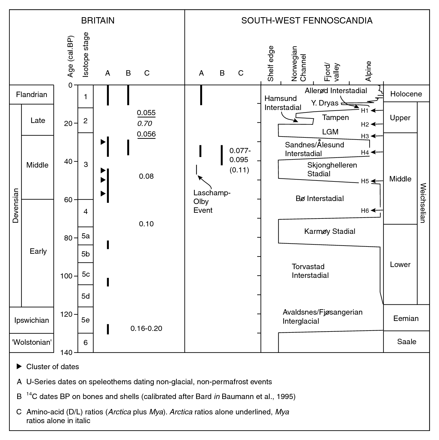
This is a summary of what we know about the Middle Devensian "warmer episode".  There was probably ice in the uplands of Scotland -- and maybe in Wales as well.  But there was salty tidewater in St George's Channel, and probably no calving ice either.  The extract below relates to Scottish evidence in particular.

What we used to call the "Upton Warren Interstadial" now appears much more complex......

http://earthwise.bgs.ac.uk/index.php?title=Onshore_stratigraphical_record,_Quaternary,_Cainozoic_of_north-east_Scotland&action=edit

Middle Devensian (OIS 3)

Periglacial and glacial environments prevailed across much of continental north-west Europe during OIS 3 and glaciers probably existed in the western Highlands for most of the time. There were relatively warm periods between 50 to 41 ka and 37 to 36 ka on the Continent (Huijzer and Vandenberghe, 1998), the former being correlated with the Upton Warren Interglacial of the British chronostratigraphy (P915253; P915254). There is also evidence of two interstadials at roughly equivalent times in the Scandinavian record (P915290). The younger of the two, the ‘Sourlie Interstadial’ is apparently represented by organic deposits beneath till in the lowlands around Glasgow, where reindeer, woolly rhinoceros and mammoth roamed in a tundra-like environment (Jardine et al., 1988; Sutherland and Gordon, 1993). Reindeer bones found in caves near Inchnadamph, Ross-shire, also date from the Middle Devensian (Lawson, 1984). However, there are no known representative organic deposits in north-east Scotland, although the district was probably free of ice. The Crossbrae Peat (Site 5) was originally thought to date from between 22 and 26.5 ka BP, but it is now correlated with OIS 5a or 5c (Whittington et al., 1998).

Sand within the glaciofluvial Byth Gravel at the Howe of Bythe Quarry (Site 6) has yielded luminescence ages of about 45 and about 37 ka, implying the presence of glacier ice in the vicinity (Hall et al., 1995b). This Middle Devensian glaciation would correlate with the Skjonghelleren glaciation of Norway (P915290), when ice probably crossed the North Sea basin (Carr, 1998; Sejrup et al., 2000).

Amino-acid ratios and radiocarbon dates on shells within rafts and tills in the Whitehills Glacigenic Formation suggest that the deposits are derived from cold-water marine muds of Middle Devensian age. More specifically, the ratios correlate with the Bö Interstadial of Norway (P915290), for which ages from 40 to 80 ka have been proposed by Miller et al. (1983) and the higher estimates are favoured by Sejrup et al. (2000). The rafts of the Clava Shelly Clay near Inverness are also thought to have been originally deposited during that interstadial (Merritt, 1992b). Oddly, there appear to be nocorrelatives of the younger Ålesund Interstadial of the Norwegian sequence in north-east Scotland (Peacock and Merritt, 1997).

=========================

On the matter of Mid Devensian sea-levels, this is a figure I have published before:


It shows that in the Mid Devensian there was still so much ice on land globally that sea-level was well depressed -- the figure for the interstadial period around 40,000 years ago seems to be c -60m to  -40m.  That gives us water in St Gerge;s Channel -- but the floor of Cardigan Bay might have been dry (or probably soggy) land.  But we still do not know how much isostatic depression there might have been; and we do not know how much Late Devensian glacial and fluvioglacial sediment has accumulated and contributed to the shallowing of the Mid Devensian sea floor.


Mullock Bridge looks important again...

Littorina littorea -- a key indicator of warmer conditions

This paper from 1972 -- yes, it really was that long ago -- starts to look very important again. This was the paper in which I questioned the placing of the Devensian Irish Sea Glacier edge across north Pembrokeshire -- something that was more or less universally accepted at the time.  I argued that the ice edge must have been somewhere near the mouth of Milford Haven, if not further south, because I could only explain the Mullock Bridge kame terrace as an ice edge feature associated with active ice in the late Weichselian / Devensian episode.  It could not, I argued, have been formed earlier, or later.

I had quite an argument at the time about my radiocarbon dating of shell fragments from the "shelly layers" exposed in the gravel pit.  The dates on two samples came out as around 38,000 yrs BP, which was out towards the limit of radiocarbon dating at the time.  Furthermore, argued my critics (including David Bowen, Fred Shotton and Francis Synge), the dates could not be considered reliable because they came from aggregate samples of small shell samples which might have been of many different ages.  The lab (NPL) was pretty sure the dates were good -- and so was I.  And to show a degree of reliability they tested just one species -- Littorina litorrea -- and came up with virtually the same date as the bulk sample dated earlier.  Littorina cannot live where there is much sea ice -- so I assumed, with specialist advice, that this was an indicator of interstadial conditions preceding the glacial episode responsible for the creation of the kame terrace.  So -- a Middle Weichselian interstadial followed by a Late Weichselian glaciation.  Between 50,000 and 30,000 yrs BP, there seem to have been non-glacial conditions in Cardigan Bay, with quite violent temperature oscillations.  Five or six different "interstadial peaks" seem to be present in the temperature record.

After all these years, by dating and my elucidated sequence of events have not been challenged -- indeed, multiple studies by others in the years that have passed have all come to the same conclusion.  So I consider my hypothesis validated or confirmed.

Below I have copied some of the key pieces of information from the PGA paper.

--------------------------------


A Late Weichselian kame terrace at Mullock Bridge, Pembrokeshire
by Brian John
December 1972
Proceedings of the Geologists Association 83(2):213-229

DOI: 
10.1016/S0016-7878(72)80008-7

https://www.researchgate.net/publication/229120558_A_Late_Weichselian_kame_terrace_at_Mullock_Bridge_Pembrokeshire

Abstract
A terrace of fluvioglacial sands and gravels is described from Mullock Bridge, near Dale. From its internal characteristics and morphological relationships it is interpreted as a kame terrace formed during the wastage of the Irish Sea glacier at the close of the area's last glaciation. The stratigraphy of the Mullock Bridge deposits is compared with that from four nearby sites, and, following an analysis of derived marine mollusca in the gravels, two radiocarbon age determinations are reported. Each line of evidence suggests that the last glaciation of the Dale area occurred during the Late Weichselian, and that the limit of the Irish Sea glacier lay at least as far south as Milford Haven.


Tuesday, 21 August 2018

South Pembrokeshire Devensian till exposures


Devensian till exposures in gullies and on clifftops are so frequent in north Pembrokeshire that there is no great point in pinpointing the localities on a map.  But South Pembrokeshire is a different matter, and for decades it has been assumed that the Devensian ice of the Irish Sea Ice Stream remained somewhere out to the west and did not touch the present coastline.  (Bear in mind that sea-level was around 120 m lower than it is today, and that the coastline was somewhere out towards the shelf edge, far to the SW.)

Well, I have been arguing for years that there was something which we can call the Carmarthen Bay ice lobe, and that the ice did indeed press as far east as Caldey Island -- and that if it did that it must also have touched the south coast cliffline in multiple locations.  I didn't have much evidence to go on, apart from some suggestive comments in the old Geological Survey memoirs written by Dixon, Cantrill and others.  Anyway, in the spring of this year I gathered evidence to supplement my earlier observations at places like Westdale, Mullock Bridge, West Angle, and Ballum's Bay on Caldey. Some of the earlier evidence is here:

https://brian-mountainman.blogspot.com/2011/08/devensian-till-at-bullums-bay-caldey.html

https://brian-mountainman.blogspot.com/2017/03/the-south-pembrokeshire-lgm-again.html

https://brian-mountainman.blogspot.com/2014/08/historic-papers-now-online.html

https://brian-mountainman.blogspot.com/2017/02/the-west-angle-enigma.html

https://brian-mountainman.blogspot.com/2017/03/the-west-angle-enigma-2-silt-and-clay.html

https://brian-mountainman.blogspot.com/2017/03/the-west-angle-enigma-3-two-tills-or-one.html

https://brian-mountainman.blogspot.com/2014/03/westdale-bay-close-to-devensian-ice-edge.html

There is another apparent till deposit at Freshwater West, exposed after freak storm conditions, which I have been unable to examine myself:

https://brian-mountainman.blogspot.com/2016/02/devensian-till-at-freshwater-west.html

You can find other posts by using the search facility on this blog.

In the spring of this year, in the course of three walks along the south Pembrokeshire cliffs (in the company of wife and several friends, who were in much more of a hurry than I was) I found a number of localities where unconsolidated till can be seen on clifftops and in gullies.  I have recorded my observations and photos here:

https://brian-mountainman.blogspot.com/2018/04/the-devensian-ice-limit-in.html

https://brian-mountainman.blogspot.com/2018/04/strange-till-near-stackpole-head.html

https://brian-mountainman.blogspot.com/2018/03/lydstep-headland-key-quaternary-site.html

https://brian-mountainman.blogspot.com/2018/05/lydstep-ancient-till-site-confirmed.html

https://brian-mountainman.blogspot.com/2018/05/devensian-till-at-lydstep.html

https://brian-mountainman.blogspot.com/2018/04/even-more-south-pembrokeshire-till.html

It's interesting that I have walked these cliffs before, many times, without properly observing or recording these occurrences -- which only goes to show that once an area is researched by somebody, that is not the end of it.  It is very easy to miss things....... and maybe, as you become more experienced and know what you are looking for, you see things that you have previously looked at without realising their significance............

There are amazing similarities between these south Pembrokeshire till occurrences and those in the Scilly Isles.  I will develop this in another post.

===================

The upshot of all of this is that what started in my mind as a working hypothesis is now -- in my mind at least -- a pretty reliable confirmation that the ice of the Devensian ISIS was in contact with the south Pembrokeshire cliffline at least as far east as Caldey Island.  And it's gratifying to see that the field workers of the BRITICE / CHRONO project are accepting this too.  I must try and convince some of those guys to come over and take some samples for cosmogenic dating,  just to add some scientific weight to my simple glacial geomorphology!


Monday, 20 August 2018

Topographic controls over ice stream behaviour


They are coming thick and fast.  Yet another paper relating to the deglacial phase of the Devensian Irish Sea Ice Stream.  This is a very technical paper, somewhat difficult to penetrate, but again there is very useful information in it.  Underpinning the conclusions of the authors are more luminescence and cosmogenic age determinations, particularly from the SE coast of Ireland.  I remember visiting those sites almost 60 years ago in the company of Francis Synge and Frank Mitchell..........

The new work is very relevant to West Wales because whatever went on here was mirrored pretty closely on the other side of St George's Channel.  So the sequence of glaciation and deglaciation over there will give us more than a few guidelines......

The model now looks like this:  Maximum extent into the Celtic Sea around 27,000n years ago.  Then extremely rapid (300–600 m per year) retreat from maximum extent, a slowing of retreat (26 m per year) during the period 25.9–24.2 ka, ice margin stabilization (3 m per year; 24.2–22.1 ka), rapid retreat (152 m per year; 22.1–21.6 ka), and finally a return to slower retreat rates (21 m per year; 21.6–19.5 ka).  The right-hand diagram reproduced above shows the assumed ice edge positions looping across St George's Channel towards Pembrokeshire in phases 1-7, each one tied to a specific Irish location.  Quote:  "Our Bayesian age model indicates that initial ice marginal retreat onto the southern Irish coast occurred at 25.9 ± 1.4 ka (Boundary 2). Retreat of the ISIS from the southern coast of Ireland is constrained by the modeled age (Boundary 3) of 25.1 ± 1.2 ka. Deglaciation to the Wexford coast, and associated deposition of the Screen Hills complex, occurred between 24.2 ± 1.2 ka and 22.1 ± 0.7 ka (Boundaries 4–7)."   So this must have been the critical period for the wastage of ice from western Pembrokeshire.  Let's hope that dating work is planned for some of the key Pembrokeshire sites...........

Now I'm going to have another gripe about the flowlines on the left-hand and middle maps.  The easternmost flowlines in the area under scrutiny cannot be correct; and it is ironic that in a paper devoted to topographic controls and trough geometry the authors are showing ice flowing from NNE towards SSW where there appears to be no topographic control whatsoever, and where the laws of ice physics say that flow must have been from NW towards SE,or perpendicular to the ice edge.  I will keep on banging on about this until somebody shows me some evidence that I am wrong.  Heyho -- all good fun!

On balance, another great contribution from members of the BRITICE-CHRONO research team.
--------------------------

https://pubs.geoscienceworld.org/gsa/gsabulletin/article/531364/Trough-geometry-was-a-greater-influence-than


Trough geometry was a greater influence than climate-ocean forcing in regulating retreat of the marine-based Irish-Sea Ice Stream (2018)
by David Small, Rachel K. Smedley, Richard C. Chiverrell, James D. Scourse, Colm Ó Cofaigh, Geoff A.T. Duller, Stephen McCarron, Matthew J. Burke, David J.A. Evans, Derek Fabel, Delia M. Gheorghiu, Geoff S.P. Thomas, Sheng Xu, Chris D. Clark

GSA Bulletin (2018) May 28, 2018
https://doi.org/10.1130/B31852.1

ABSTRACT
Marine terminating ice streams are a major component of contemporary ice sheets and are likely to have a fundamental influence on their future evolution and concomitant contribution to sea-level rise. To accurately predict this evolution requires that modern day observations can be placed into a longer-term context and that numerical ice sheet models used for making predictions are validated against known evolution of former ice masses. New geochronological data document a stepped retreat of the paleo−Irish Sea Ice Stream from its Last Glacial Maximum limits, constraining changes in the time-averaged retreat rates between well-defined ice marginal positions. The timing and pace of this retreat is compatible with the sediment-landform record and suggests that ice marginal retreat was primarily conditioned by trough geometry and that its pacing was independent of ocean-climate forcing. We present and integrate new luminescence and cosmogenic exposure ages in a spatial Bayesian sequence model for a north-south (173km) transect of the largest marine-terminating ice stream draining the last British−Irish Ice Sheet. From the south and east coasts of Ireland, initial rates of ice margin retreat were as high as 300−600 m a−1, but retreat slowed to 26 m a−1 as the ice stream became topographically constricted within St George’s Channel, a sea channel between Ireland to the west and Great Britain to the east, and then stabilized (retreating at only 3 m a−1) at the narrowest point of the trough during the climatic warming of Greenland Interstadial 2 (GI-2: 23.3−22.9 ka). Later retreat across a normal bed-slope during the cooler conditions of Greenland Stadial 2 was unexpectedly rapid (152 m a−1). We demonstrate that trough geometry had a profound influence on ice margin retreat and suggest that the final rapid retreat was conditioned by ice sheet drawdown (dynamic thinning) during stabilization at the trough constriction, which was exacerbated by increased calving due to warmer ocean waters during GI-2.

CONCLUSIONS

The geochronological data presented here allow us to test a conceptual model of ISIS deglaciation in south and east Ireland inferred from the sediment-landform assemblage record. Integration of new geochronological data using Bayesian age modeling produces a conformable age model that supports the conceptual model of deglaciation, with extremely rapid (300–600 m a–1) retreat from maximum extent, a slowing of retreat (26 m a–1) during the period 25.9–24.2 ka, ice margin stabilization (3 m a–1; 24.2–22.1 ka), rapid retreat (152 m a–1; 22.1–21.6 ka), and finally a return to slower retreat rates (21 m a–1; 21.6–19.5 ka).

This timescale strongly suggests that aspects of ISIS behavior during deglaciation displayed a complex relationship to external climatic forcing. Extremely rapid advance of the ISIS to its maximum extent, and its subsequent retreat at 26–25 ka is not directly correlated with distinct climate forcing in the North Atlantic region. Such behavior may be explained as a dynamic instability in response to overextension of the ice stream to the maximum limit that rendered it vulnerable to rapid retreat. Similarly, the stabilization of the ice margin at the Screen Hills spans a time of distinct warming (GI-2) with the subsequent rapid retreat occurring during colder conditions of GS-2. The stabilization at the Screen Hills is the most distinct change in pace of ISIS retreat evidenced by the data presented here and it occurs where there is a step-change in the con ning trough geometry highlighting the important role that this plays in condition- ing ice margin retreat. However, contrary to this, the ISIS subsequently underwent rapid retreat without major changes in trough geometry. We speculate that this represents a delayed response of the ice margin to the climate forcing of GI-2. Overall, changing trough geometry and internal feedbacks related to the overextension, retreat, and stabilization of the ISIS appear to obscure the role of external drivers such as climatic forcing.

The conceptual model and geochronological data presented here provide evidence for specific ice margin behavior during overall deglaciation that provides a testing ground for numerical models that likely require high resolution representations of grounding line dynamics. As contemporary ice streams in Greenland and Antarctica evolve in response to anthropogenic climate change they will undergo retreat that is conditioned both by climatic forcing and their internal dynamics. Our data highlight the potential for the evolution of rapid ice margin retreat to be highly nonlinear and conditioned strongly by trough geometry.