THE BOOK
Some of the ideas discussed in this blog are published in my new book called "The Stonehenge Bluestones" -- available by post and through good bookshops everywhere. Bad bookshops might not have it....
To order, click
HERE
Showing posts sorted by date for query Thomas ice edge. Sort by relevance Show all posts

Wednesday, 2 September 2026

Herbert Thomas and the German erratics


I have been doing more research on the origins of the human transport hypothesis (I won't call it a theory today, since it is not supported by enough evidence) and have discovered a delicious irony.  

The inventor of the human transport idea was of course geologist Herbert Thomas, around 1918-1921 -- formulating his ideas in the years after the end of the Great War.  Anyway, in 1921—just three years after the armistice -- Thomas wrote his famous paper tracing the bluestones to the Preseli Hills. At that moment in history, British archaeology was deeply entangled with national identity. The devastating loss of life in the Great War left a fractured national psyche that desperately needed a narrative of ancient British exceptionalism, organization, and cultural supremacy to counter the dominant German archaeological schools of the era and the exciting Neolithic discoveries made in Germany.

To restore national pride, British academic institutions desperately sought narratives of ancient domestic superiority.  Emphasizing that British Neolithic tribes possessed great enough intelligence, social cohesion, and engineering genius to manually haul multi-tonne monoliths across hundreds of miles of wilderness served as a powerful cultural balm. It explicitly positioned ancient British society as far more "civilized" and sophisticated than its continental German contemporaries.  I have dealt with this issue before on this blog, with thanks to Stephen Briggs and David Keys of the Independent newspaper:

In don't for  moment believe that Thomas was an independent and objective scientist simply reporting on his findings and drawing sensible conclusions from his evidence.  He knew exactly what he was doing.


This is what I have said earler about Thomas's deliberate distortion /manipulation of the evidence of glaciation:

All things considered, the accumulated evidence shows that by 1910 the broad outlines of glaciation in the Bristol Channel / Celtic Sea arena were already established, involving thick and active ice carrying erratics and other glacial materials from the NW across Pembrokeshire and up the Bristol Channel, affecting the coasts of South Wales and the South-West Peninsula. In making his claims about the impossibility of bluestone transport towards Stonehenge HH Thomas wilfully ignored a great amount of evidence in the printed literature, and wilfully misrepresented the opinions of senior "glacialists". It is quite extraordinary that he got away with it -- but that, maybe, was because he was a geologist talking to archaeologists or antiquarians. If he had been a geologist talking to other geologists, he would certainly not have got away with it. They would have had his guts for garters.

Ixer and Bevins have also questioned his competence as a field geologist and petrologist..........
http://www.sciencedirect.com/science/article/pii/S0305440313001076
https://doi.org/10.15184/aqy.2018.10

Anyway, leaving aside Thomas's professionalism and his integrity, he has had pretty much a free ride from the academic community, since most archaeologists and even most geologists seem to have accepted the reliability of what he had to say.  The narrative that he outlined was warmly accepted and then eagerly developed by the likes of Atkinson, Wainwright and Parker Pearson -- and even initially by other geologists.

Now, more than a hundred years later, we come full circle.  We now know that Salisbury Plain behaves identically to  continental equivalents over deep time, where older glacial tills on Cretaceous chalk undergo geomorphological erasure through chemical weathering and periglacial activity. This absence of coherent till reflects the defining characteristics of parts of the North European Old Drift Landscape (Altmoränenlandschaft) created in the Anglian glaciation but unaffected by later ice incursions.


Nobbin megalithic tomb, North Germany


Hünenbett on Riesenberg, near Nobbin, North Germany
 
A century later, standard European geomorphology reveals that German and Danish contemporaneous tribes were simply harvesting natural, large glacial lag erratics left on chalk downlands subject to quite rapid surface lowering.  They had no need to go hunting for rock outcrops or to open monolith quarries.  They used erratic boulders more or less where found, to create structures thet were sometimes quite complex.  By defending the human transport model as an immutable truth, modern orthodoxy is not defending robust field data; it is inadvertently protecting a piece of post-WWI anti-German political propaganda from 1921.

It will be a beautifiul irony if a deepeer understanding of megalithic structures made of glacial erratics on a chalk bedrock base in Northern Germany demonstrates once and for all that the Stonehenge "human transport" scenario is altogether unnecessary, and that the promotion of a wildly fanciful bluestone narrative by HH Thomas and his successors has been a complete waste of time.

-------------------

See also:

on the perceived value or significance of glacial erratics.

Thursday, 27 August 2026

Salisbury Plain: serene landscape but lethal geochemistry


Almost all of the textbooks and archaeological papers that devote space to the Stonehenge bluestones make three claims:  (1) that there is no till or any other glacial deposit on Salisbury Plain; (2) that glacial erratics are entirely absent; and (3) that Salisbury Plain was beyond the reach of any known British glacier or ice stream.  

The latter claim was of course made by HH Thomas back in 1923, and has been taken as an article of faith ever since then, even by certain geomorphologists who should know better.  We now know that Thomas misrepresented the evidence by falsely claiming that the outermost ice edge in the Celtic Sea / Bristol Channel arena lay just to the south of the south Pembrokeshire coast, flying in the face of evidence from many of his peers that the ice had on occasions extended much further southwards and eastwards.  We now know that there are abundant traces of glaciation on the coasts of Somerset, Devon and Cornwall -- although evidence of the inland incursion of glacier ice is still hotly debated.  Nonetheless, we know from field research and from modelling studies that it was perfectly possible for glacier ice to have extended well to the east of the chalk escarpment.  Many of these studies have been cited on this blog.


An attempt to portray the extent of the "Greatet British Glaciation", based on computer modelling by various authors and on field evidence.  This is a cautious reconstruction in that the ice margin is shown at the western edge of Salisbury Plain.  Some models show the chalk downs and Salisbury Plain WITHIN the glaciated area.


One of a multitude of computer models showing a somewhat greater ice extent.  This is from Edwards et al, 2017.  Models like this are not "evidence" of past glaciations -- they are mathematical models based on an author's understanding of glaciological theory and an interpretation of field evidence.  As with all modelss of this type, rubbish in, rubbish out.......

As far as erratics are concerned, it is disingenuous to pretend that they do not exist on Salisbury Plain.  As pointed out by Kellaway, Olwen Williams-Thorpe and many others, they are abundant -- with at least 40 different rock types represented in the bluestone monolith / cobble / packing stone assemblage and in the debitage at Stonehenge and further afield.  Whether these erratic materials can be labelled as "glacial erratics" is another question entirely.  But as I have repeated many times, bluestone shapes and surface characteristics point unequivocally towards glacial entrainment and transport -- and if things look like glacial erratics, that is probably what they are. Why is that such a big deal?

Then we come to the claimed absence of glacial deposits on Salisbury Plain. Well, absence of evidence is not evidence of absence -- and the great majority of the sediments on Salisbury Plain are of course unexplored and unknown.  Even within the Stonenge stone setting, 50% of the surface sediments have never been investigated.  With the "impossibility of glaciation" accepted as an article of faith, we see confirmation bias in almost every study in the literature.  Over and again we see that sediments containing foreign erratic material are immediately dated as younger than the supposed known date of bluestone arrival; it does not seem to have occurred to the establishment faithful that "date of first use" is not at all the same as "date of arrival", and that erratics might well have been lying around in the Stonehenge area for hundreds of thousands of years before people arrived and started messing about with monumental ambitions.

So could there be glacial deposits lying around on Salisbury Plain, undiscovered?  Of course that is a possibility.  We see various clues in the strange and intriguing deposits lumped together under the "clay-with-flints" label.  But then we come to a point that is hardly ever made by archaeologists, geologists or anybody else: namely that the chalk downs of Salisbury Plain and adjacent areas are geochemically lethal, and are perfect places for the efficient degradation and destruction of any scattered patches of till and glaciofluvial deposits that might once have existed

If glacial ice did once extend across the chalk downs, what might the  traces of this glaciation have looked like?  Well, there will probably not have been any massive terminal moraines located at ice edges.  Prior to ice arrival near the peak of a glacial episode, we can assume that the ground surface would have been deeply frozen or locked in permafrost.  That points in turn towards cold-based ice, moving slowly and not affecting much basal erosion -- and in turn not depositing vast thicknesses of till and other materials such as we see in parts of Eastern England where chalk bedrock underlies Late Devensian and other till sheets.

Lee and Roberson (2025) contains an interesting discussion on the types of glacial features that occur in the ice marginal zone, dependent upon thermal regime, bedrock characteristics etc.  They make the point that the edge of a till sheet rarely marks the maximum extent of ice in a landscape.

https://www.sciencedirect.com/science/article/pii/S0016787824000683

So, around 450,000 years ago, if the chronology of ancient glaciations is correct, there may well have been a patchy spread of glacial and glacio-fluvial deposits on the chalklands of Salisbury Plain.  So should they not still be there, available to be mapped and examined?  The short answer to that is "No".  The long answer is that the geochemical environment on Salisbury Plain is far too aggressive -- and even lethal -- for ancient glacial deposits to have survived.  The deposits -- however extensive they might have been -- would have been quite calcareous, as demonstrated by the Devensian Irish Sea till of the west Wales coasts and by the Fremington Till on the coast of Devon.  It must have been composed for the most part of clay and silt deposits dredged from the floor of the Bristol Channel, with other calcareous additions coming (for example)  from the Mendips and from the Black Rock limestone beds around Frome.  Gilbertson and Hawkins, and other workers, have described the till deposits of Somerset and their associations with marine shell fragments, suggesting a shared chemistry.  

So the Salisbury Plain till was probably calcareous -- meaning that its chances of long-term survival were virtually zero.  Because the chalk is highly porous and lacks cementing minerals, rainwater mixed with soil acids percolates straight down, soaking the landscape. Any loose calcareous sediments dropped onto the plain (such as limestone erratics or older shelly sands) are subjected to continuous, downward leaching by acidic water. Without the specific point-source degassing or coastal evaporation seen in Wales to precipitate cements, the carbonate is entirely dissolved and flushed deep into the aquifer, leaving no physical trace.  This aggressive leaching is so intense that even relatively resilient detrital minerals (like apatite) are chemically dissolved and structurally stripped from Salisbury Plain's surficial layers over hundreds of thousands of years.

However, in this broadly very destructive scenario, the chemistry also shows that erratic boulder survivals are not just possible but probable.  Sarsen stones derived from an ancient duricrust layer were eminently survivable, being composed of almost 100% silica.  The "bluestone" lithologies from Pembrokeshire—primarily spotted dolerite (diabase) and various rhyolites/tuffs—are composed of highly resilient silicate minerals like quartz, plagioclase feldspar, and pyroxene. Unlike calcium carbonate, these minerals are resistant to weak carbonic acid.  Even if small carbonate grains dissolve, un-weatherable microscopic minerals do not disappear.  Igneous rocks like the Pembrokeshire igneous bluestones are packed with ultra-durable heavy trace minerals, such as zircon, rutile, tourmaline, and apatite.  Placed on Salisbury Plain, a large dolerite block would be expected to survive hundreds of thousands of years of chemical weathering, whereas a limestone or chalk pebble in a surrounding till matrix would dissolve completely.

In addition to the "chemical hostility" of the Salisbury Plain environment, we have to consider the physical weathering effects of climate change over almost half a million years -- with  multiple oscillations in wetting and drying, heating and cooling.  Chalk absorbs a lot of water.  During past permafrost freeze-thaw cycles, the surface layer of chalk must have shattered into a fine, paste-like slurry.  Any glacial till, erratic boulders, or paleosols caught in this zone would also have been violently churned up by cryoturbation and washed down valleys as mobile gravelly solifluction deposits (historically termed "coombe rock" or "head"). Because these redeposited sediments could not cement together, they remained loose, soft, and completely vulnerable to being wiped away by subsequent fluvial and colluvial processes during warmer episodes.


So the scenario is one of widespread sediment destruction with some survivals.  What of the residues and lag deposits that must remain when calcium carbonate rich rocks are dissolved away?  This is where we return to some of the enigmatic sediments on Salisbury Plain -- and in particular the "clay with flints" that we have discussed on many occasions.  The physical and mineralogical composition of this material strongly proves that it contains a large amount of detritus that did not come from the underlying chalk.  Pure chalk contains very little clay and sand. To produce a one-metre-thick layer of clay-with-flints purely from chalk dissolution, you would have to dissolve hundreds of metres of bedrock. Mineralogical analyses show that much of the matrix clay (like illite and kaolinite) and quartz sand actually comes from reworked, younger overlying formations (like the Paleogene Reading and Thanet Formations) and unknown exotic surficial inputs.  In many areas of the downlands, the clay-with-flints loses its classic red-clay appearance and grades into poorly sorted, unstratified, gravelly deposits packed with sub-angular flints and erratic quartzites. This structural signature is virtually indistinguishable from a highly weathered, decalcified, cryoturbed periglacial "head" or an ancient, deeply rotted till or fluvioglacial accumulation.

Despite the heavy dilution, geologists have occasionally confirmed a persistent presence of exotic "foreign" stones. Round, exotic quartzite pebbles (often historically lumped together as part of the "Northern Drift" or derived from old Triassic Pebble Beds) are well-documented across the downlands. These are classic indicators of far-travelled, non-local glacial, fluvioglacial or fluvial transport.  Over the decades, independent Quaternary geologists (most notably our old friend Geoffrey Kellaway) reported finding small, erratic pebbles of igneous and metamorphic material—including fragments resembling southwestern and Welsh lithologies—in deep solution features and surficial deposits across the wider Wessex region.

Ah -- solution features.  Now we are getting serious, and feel another comment about Parker Pearson's "periglacial stripes" coming on.  Watch this space.........


Tuesday, 7 October 2025

Kjove Land -- ice flow west to east, or east to west?


New satellite image showing with great clarity the morainic ridge remnants in the vicinity of Hjörnemoraene (Corner Moraine) in Kjove Land.  It is clear from this evidence that a diffluent lobe of ice flowed down from the interior of the Pythagoras Massif.  This was probably contemporaneous with ice from the main Nordvestfjord Glacier spilling eastwards across Syd Kap Bay and possibly terminating at a floating ice edge near Nordostbugt.


Map of raised marine features in Kjove Land, from our 1965 paper.  With no satellite imagery at our disposal, we failed to recognise the evidence for the Pythagoras Bjerg diffluent ice lobe.

A fascinating new paper has been published:

https://www.sciencedirect.com/science/article/pii/S0277379125003518?via%3Dihub

https://doi.org/10.1016/j.quascirev.2025.109531


Relative summer temperature changes from glacial fluctuations in the Scoresby Sund region, Central East Greenland, during late-glacial time (2025) 
Meredith A. Kelly, Thomas V. Lowell, Brenda L. Hall, Laura B. Levy, Colby A. Smith, Katherine Salamido, Roseanne Schwartz and Jennifer A. Howley
Quaternary Science Reviews
Volume 367, 1 November 2025, 109531

Abstract

Understanding climate conditions in the mid-to-high-latitude North Atlantic region during late-glacial time can provide valuable information to test hypotheses concerning the mechanisms of climate change that ended the last glacial period. Glaciers (particularly mountain glaciers) are sensitive recorders of summer temperature change because of its influence on the ablation season, snowline elevation and, hence, glacier length. Here, we develop a record of glacial fluctuations in the Scoresby Sund region in Central East Greenland and use these data to infer the timing and pattern of summer temperature changes in the mid-to-high-latitude North Atlantic region. We present 64 new 10Be ages of glacial landforms and remap and recalculate an additional 65 10Be ages from prior work in the region. Even with boulders with inherited nuclides in some of the datasets, a two-step pattern of glacial fluctuations is apparent, with an outer moraine dating to ∼14.0–12.8 ka, an inner moraine dating to ∼11.7–11.3 ka, and ice retreat in the time between moraine deposition. A comparison of these data with 10Be chronologies of mountain glacier fluctuations in Northeast Greenland, Svalbard, Norway and Scotland, shows a consistent pattern throughout the mid-to-high-latitude North Atlantic region of summer cooling and warming during late-glacial time.

Quote:

In both Holger Danskes Briller and Kjove Land, prominent lateral moraines demarcate a relatively young landscape (proximal to the moraines) from this older, more weathered landscape (distal to the moraines). Lateral moraines occur on both walls of Holger Danskes Briller and mark the margins of a glacier that filled the valley and flowed into Nordostbugt (Fig. 3, Fig. 6). On the right-lateral (south) valley wall, these moraines are contiguous with moraines in Kjoveland that mark the left-lateral margin of an ice-sheet outlet that filled Nordvestfjord. All these moraines are relatively high relief and have high surface boulder concentrations. Based on the geomorphology and elevations of the highest elevation lateral moraines in Holger Danskes Briller (both ∼300 m asl) and Kjoveland (∼260–280 m asl), we assume that they were deposited at the same time. 10Be ages of thirteen boulders on these highest elevation moraines are ∼11.8–18.9 ka. Multiple lateral moraines occur on the slopes below the highest moraines. We dated five boulders on lower elevation moraines (∼190–240 m asl) in Kjoveland. Four ages are ∼12.1–16.4 ka and one (∼30.4 ± 1.1 ka, MKG-71) is a statistical outlier. Based on their prominence and position at a weathering boundary, we consider all of these landforms to be associated with the outer moraine set. They consist entirely of lateral moraines and lack terminal features, possibly because the ice terminated offshore. The peak age of the moraines is ∼12.2 ka (n = 17) and the youngest age is ∼11.8 ± 0.4 ka (MKG-179)(Fig. 6).

In contrast, on the Holger Danskes Briller valley floor, an ice-contact delta is spectacularly preserved, with a steep and boulder-covered ice-contact slope and kettles and meltwater channels on its surface (Fig. 3E). The upper delta surface is at ∼101 m asl. 10Be ages of seven boulders on the delta are ∼11.6–15.3 ka with a peak age of ∼11.7 ka (n = 7) and youngest age of ∼11.6 ± 0.3 ka (MKG-172)(Fig. 6). Given the substantial distance between inferred minimum terminal ice positions of the outer moraines and this ice-contact delta, as well as the fact that the delta grades to 101 m asl, well-below the 135 m asl sea level associated with at least one outer moraine in Gurreholm Dal, we conclude that the delta is associated with the inner moraine set.

----------------

The paper contains some fascinatingf material, particularly withy respect to the cosmogenic dating of assorted morainic features.  This is a wonderful image of the HDB ice-contact delta, associated with a sea level at 101m:


Because of its association with a sea level at 101m, the authors suggest that the HDB feature is one of the "inner moraines", linked in age (c 11,000 yrs BP) and origin to some of the moraines associated with the glaciers in the Schuchert Valley.

However, in trying to understand the complexities of the morainic topography of the area around Hjörnemoraene, I think the authors have missed the point that there was (1) a diffluent ice lobe coming from the Pythagoras Bjerg plateau, with a loop of moraines around 270m asl; (2) a series of lateral moraines at a lower level, around 200 - 190 m asl, associated with the Nordvestfjord outlet glacier; and (3) an intervening "proglacial" strip of land characterised by older morainic deposits and some washed surfaces. This can be picked up rather clearly on Figure 6 of the article:


Sampling point 83, labelled as "distal to moraines" should have been labelled "proximal to moraines" because it is inside the diffluent glacier morainic loop.  This makes sense, because the date (13,600 yrs BP) is younger than some of those obtained from boulders on the moraines themselves.


The highest ridge of lateral moraine associated with the Nordvestfjord Glacier at c 200m, near Hjörnemoraene.  Additional annotations by me -- on the authors' Fig 3.


My annotations on another of the authors' photos, in Fig 3 of the article. This is a close-up of the same ridge featured in the photo above.

All in all, a somewhat messy situation, with the morainic features of Kjove Land interpreted in three different ways.  In 1965 David Sugden and I interpreted the features as associated with two glacier retreat stages or readvances, coinciding with sea-level stillstands at 134m and 101m.


We has no sophisticated dating techniques available to us in 1962, but we used shell faunas in the Gurreholmsdal raised delta staircase in our interpretations, and our estimates of the nature of the morainic and delta features and their ages were not far wide of the mark.

In some of the early papers on the Milne Land Stage it was assumed that the Kjove Land and Pythagoras Bjerg moraines were associated with an extended Schuchert Glacier, flowing down the Schuchertv Valley and then pushing into Hall Bredning and westwards across Syd Kap Bay.  That idea does not seem to be supported by any of the more recent papers.  The third interpretation, involving a lobe of diffluent ice pushing south-eastwards from the plateau of Pythagoras Bjerg, is one I am increasingly attracted by, as seen in assorted posts on this blog.

I think the landforms of the plateau suggest a long history of diffluent ice flow, maybe during several distinct glaciations.   But the most recent ice flow, associated with the creation of two sets of prominent morainic ridges above Hjörnemoraene, appears to have been associated with the Late Glacial readvance that occurred around 13,000 years ago.

The new work -- associated with an extensive cosmogenic dating programme -- confirms that the late-glacial readvance phases here were not very closely synchronised with the old Zone I (cold) >> Zone II / Allerodn (warmer) >> Zone III (cold) sequence.   Everything here in East Greenland seems to have been slightly out of step, for reasons still to be properly elucidated.

The "Younger Dryas Question" has still not been satisfactorily answered.......

================

PS.  Some more old photos found in the slide collection:


View from one of the morainic ridges towards Syd Kap Bay


1962 photo of the highest morainic ridge -- virtually the same view as that in one of the photos published above.


B/W view of the highest shoreline against the morainic ridge.


Thursday, 7 August 2025

Freshly quarried monoliths, or ancient glacial erratics?


One of the most bizarre features of the glacial transport / human transport debate is the insistence of the HT advocates that the Stonehenge bluestones are freshly quarried monoliths that just happen to be somewhat weathered.  Their narrative requires quarrying from special places  -- but of course there is no evidence at all that Rhosyfelin or Carn Goedog were "special places" in Neolithic times, and neither foliated rhyolite or spotted dolerite were ever used preferentially in West Wales by the builders of the megalithic structures.  And as for the evidence of quarrying, we all know that it is so thin that it cannot withstand scrutiny, as Dyfed Elis-Gruffydd, John Downes and I demonstrated in two papers in 2015.  (For a decade, these highly inconvenient papers have been entirely ignored by MPP and his associates.  Make of that what you will.)  Indeed, our careful analysis of the "quarrying features" showed them to be entirely natural and unexceptional.  The sedimentary sequences at the two sites, and the radiocarbon age determinations, also fail to demonstrate that there ever were obvious "quarrying episodes" in the time frame desired by MPP and his colleagues.

Now the narrative appears to incorporate other Neolithic quarries and other stone circles as yet undiscovered, at sites that are deemed  (by modern archaeologists) to have been sacred or special.  Fantasy rules, at every stage of the narrative.

The stone provenancing work by Ixer, Bevins and associated colleagues is interesting in demonstrating a "North Preseli" connection with Stonehenge, but it is a good deal less definitive than they would have us believe, and it tells us nothing at all about how boulders, smaller stones, cobbles and fragments of many different rock types may have travelled from A to B.  It is one of the most unfortunate features of this debate that the geologists from an early stage decided to side with the HT proponents and to promote the view that GT was impossible.  It is even more unfortunate that they decided to support the view that the bluestone monoliths were taken from Neolithic bluestone quarries rather than being collected as boulders from an erratic-strewn landscape.

So what about the Stonehenge bluestone monoliths?  As night follows day, they are obviously NOT freshly quarried blocks.  Some of them have been tooled and shaped, like the dolerites in the Bluestone Horseshoe, but to pretend that the other boulders, blocks and slabs were transported as targetted and freshly quarried blocks is to deny everything we know about weathering and erosional processes.  The facets, the abraded edges and the weathering characteristics all indicate glacial entrainment, transport in a dynamic sub-glacial or englacial environment, and long exposure to weathering processes.  By this I mean tens of thousands of years at the very least.

It is disingenuous of the HT brigade to pretend that the rounding and weathering of the Stonehenge bluestones might have occurred over the last 5,000 years or so, and that in scale and character it is similar to that displayed on rock surfaces at Rhosyfelin and Carn Goedog and on the surfaces of the Stonehenge sarsens.  In arguing that way, they are making my point for me, since the bedrock surfaces, and the surfaces of the sarsens, are the results of very long exposure to the elements.  HH Thomas accepted this point a century ago, when he argued that the Stonehenge bluestones were not quarried but picked up from an erratic scatter somewhere on the south side of Preseli.

It is really rather weird that the earth scientists who belong to the "group of eleven" who have so recently attacked me and my work on the Newall Boulder should apparently be so naive about the physical processes that operate on rock surfaces.  They claimed that the Newall Boulder was simply the broken off top of a rhyolite monolith which has subsequently suffered from a certain amount of weathering.  As I have demonstrated, it is a great deal more complicated than that, with both weathering and erosional features demonstrating a complex transport and emplacement history in which glacier ice almost certainly played a part. The apparent lack of clear glacial striations on the boulder cannot be used as part of an argument against glacial transport, as every glacial geomorphologist knows.

As I have indicated in my recent publications, the shapes and surface characteristics of the Stonehenge bluestones are entirely consistent with glacial entrainment, glacial transport, dumping in locations still to be determined, and then long exposure to atmospheric weathering processes.  The boulders might even have been entrained, transported and dumped on multiple occasions.  There is a vast literature on glacially transported clasts, as demonstrated by stone shape, sphericity, surface roughness and other measures.  See the work of Prof David Evans and many others.  These are quotes from my 2024 Newall Boulder paper:

https://doi.org/10.5194/egqsj-73-117-2024

Clasts occupy a wide range of positions in mobile subglacial till (Evans et al., 2016, 2018). They are subject to complex transport histories that involve variable amounts of dragging, rolling and lodging, during which they are subject to surface modification through inter-clast collisions and contacts. Any single clast may be reworked numerous times during successive glaciations.  Because clasts will tend to take the line of least resistance to the flow of the surrounding deforming till matrix, facetted and bullet or wedge shapes are developed. Whenever a clast is disrupted from its lodged position, it can be subject to fresh fracturing, gradually changing its overall shape to one of a block (Boulton, 1978; Benn and Evans, 1996; Evans, 2018).  Although not all glacially transported clasts display such bullet or flat-iron shapes, such an appearance is diagnostic of significant subglacial transport (Evans, 2018; Evans et al., 2006).

.............  Overall, the surface characteristics of this boulder suggest that it is a discrete erratic that has been  transported for much if not all of the time in a subglacial position (Benn and Ballantyne, 1994; Lukas et al., 2013; Benn and Lukas, 2021).
It should be noted that most of the 43 bluestone “monoliths” at Stonehenge are not elongated elegant pillars (as portrayed in most reconstructions) but heavily abraded unremarkable boulders and elongated slabs. There are clearly defined facets, some of which are rough and others smooth. There are few sharp edges. The stones would not be out of place in the morainic accumulations around any glacier snout in the world (Benn and Evans, 2010, and references therein). They look like glacial erratics, and they are heavily weathered as a result of prolonged exposure (Fig. 14). On some weathered surfaces segments of the crust have peeled away and have been lost. It is probable that Stonehenge was built where the stones were found, as suggested by Judd (1903) and Field et al. (2015), and this is supported here by the preliminary analysis of the Newall Boulder.

In addition, I have done post after post on this blog, making the point that most of the Stonehenge bluestones are not pillars, and neither are they sharp-edged quarried blocks:


If they were quarried, they would look like the blocks in these wondrous artists impressions. The upper one was drawn to illustrate the Rhosyfelin "quarry" with the approval of MPP, for a Stonehenge exhibition in Belgium in 2018.


Whatever the flights of fancy and scale distortions might have been in these reconstructions, the detail relating to the extracted block edges is quite correct:  they are always sharp and clearly defined.


Next, let's look in more detail at the methods employed by geomorphologists in defining clast shapes.  In my paper on the Newall Boulder I referred to the scheme developed by Powers (1953):

Powers, M. C.: New roundness scale for sedimentary particles, J. Sediment. Res., 23, 117–119, 1953

https://doi.org/10.1306/ D4269567-2B26-11D7-8648000102C1865D.

Other schemes are available. There is a vast literature, but  roundness / sphericity scales like this are frequently employed in geomorphology and petrography:

(after Krumbein and others)

The shape of blocks, pillars and slabs extracted from bedrock outcrops will vary according to fissures and fracture patterns within the rock; some rocks are massive and coherent, with few internal weaknesses, while others (like shales, mudstones and maybe even foliated rhyolite) will break down into slabs, sheets and plates such as we see on slate quarry spoil heaps.  We must also take account of surface roughness in assessing clast origins.  In general, quarried blocks and slabs will be classified, on this scheme, as angular, on the left edge of this diagram.  But the stonehenge bluestones occupy quite different positions on the diagram, mostly in roundness categories 0.7 (rounded) and 0.9 (well rounded) but with some fresher and rougher facets such as those observed on glacial erratics..  This is not a consequence of weathering, but an indicator of travel distance, breakage and erosion.

Finally, there are three pieces of evidence that allow us to reject the quarrying hypothesis without further ado.

1.  If Parker Pearson and his colleagues are to be believed, the rounding and abrasion which we see on the standing bluestones today are the result of "weathering" in the time that has elapsed between stone extraction and the present day.  That involves a fundamental misunderstanding of the word "weathering", but we'll let that pass for now.  More to the point, all of the excavations which have revealed fallen and buried bluestones suggest that they are just as abraded, rounded and weathered below ground as above ground, with some rougher surfaces on facets such as we see on glacial erratics close to current glacier fronts. That means that (with the exception of a few worked stones) their shapes were already established prior to erection in the stone settings.  That means they were not installed as fresh quarried blocks, but gathered up as weathered and abraded boulders from the landscape as suggested by HH Thomas, Kellaway, Thorpe et al, and Field.  The MPP claim that the bluestones were pre-used in lost stone circles does nothing to support the quarrying hypothesis.


The "proto-orthostst" at Craig Rhosyfelin.  The sediments that have accumulated around and above the slab since the Early Bronze Age are clearly displayed.


2. The famous 8-tonne proto-othostat found at Rhosyfelin and flagged up as "intended for Stonehenge" was discoverd through radiocarbon dating to have been emplaced during or later than the Bronze Age.  Some charcoal found beneath it was radiocarbon dated to the Early Bronze Age.   So it cannot possibly have had anything to do with Neolithic quarrying at the site.  But because it is a rockfall slab which has crashed down from the higher part of the rock outcrop, and because it has been there for more than 3,000 years, its condition is of considerable importance. I have analysed it in detail:  

https://brian-mountainman.blogspot.com/2015/05/the-famous-rhosyfelin-proto-orthostat.html


It is very fresh in its appearance, with very little rounding off of sharp edges or other weathering traces in spite of exposure to the atmosphere and to other processes during and after burial by slope deposits. This reinforces the view that the Stonehenge bluestones carry surface features that are not just 5,000 years old but are the result of tens or hundreds of thousands of years of exposure.


Rock surfaces on the Pentre Ifan cromlech.  It is now suggested that the pillars and capstone were not buried for any great length of time.  After thousands of years of exposure to weathering, the smoothed and abraded faces, and those damaged by fracturing, are remarkably fresh.

3.  It is instructive to  examine the surfaces of the capstones and supporting pillars of Pembrokeshire cromlechs like Pentre Ifan, Carreg Samson and  Carreg Coetan Arthur.  The stones used by the builders were all large erratics of rather local origin and collected in the neighbourhood.  The stones are weathered but in places seriously damaged by fracture scars -- in other words, the features attributable to glacial processes and periglacial modification (frost damage) are beautifully preserved.  These cromlechs are approximatelt the same age (or maybe somewhat older) as the bluestone stone settings at Stonehenge.  Over 5,500 years or so of exposure, there has been weathering, but there is no sign at all of weathering on the scale which Bevins et al (2025) require for the creation of the facets and smoothed surfaces of the Newall Boulder.

To sum up, the bluestone quarrying hypothesis is not worth the paper it is written on, and neither is the contention that smoothed rock surfaces are the result of post-Neolithic weathering processes. 


Monday, 8 April 2024

What did HH Thomas know about the extent of glaciation?

I have been digging up some more info about what HH Thomas knew or did not know when he presented his controversial views on the transport of the bluestones in 1923.  (And in 1921, actually......)  

Let's take 1910 as a reasonable date to look at.  The "state of play" was determined at the time by such senior geologists and "glacialists" as James Geikie (far more important than his older brother Sir Archibald), Carvill Lewis, Frederick Wright,  Thomas Jehu and John Wesley Judd. 


Henry Carvill Lewis (1853-1888) , an American who did much fieldwork in the British Isles.  He proposed that the edge of the great Ice Age glaciation in Britain  coincided with a line of prominent moraines and other features which could be traces across country.  At first he found it difficult to accept that traces (such as erratic boulders) south of his limit were genuinely related to the presence of glacier ice, and he initially assigned them to some great Ice Age Flood. But later in his all-too-short life he fell into line with Geikie and others and did accept that the maximum position of the ice edge in the Ice Age was well to the south of his hypothetical line. 


Prof James Geikie (1839-1915), a Scottish geologist who was convinced that there was very extensive glaciation in the Ice Age, and that the ice limit in SW England lay somewhere off the Cornish coast. he was also active in promoting the idea that there had been several glaciations, separated by warmer intervals or interglacials.


Frederick Wright’s map of 1895, showing a strange ice limit across South Wales, based in part on Carvill Lewis’s identification of assumed terminal moraines. Wright ignored the abundant records of far-travelled erratics to the south of this line.


Europe and the greatest extent of glaciation during the Ice Age. From “Prehistoric Europe - A Geological Sketch”, by James Geikie (Edward Stanford, London, 1881). Note that Geikie incorporates the whole of the Bristol Channel area into the glaciated area, with an ice edge on or near Salisbury Plain……..


In this map, also from Wright (1895) a highly generalised line, based on the work of James Geikie, is drawn well to the south of the “moraines” identified by Carvill Lewis. Geikie recognised that the abundance of glacial erratics around the Bristol Channel coasts indicated extensive glaciation, at least as far south as the Cornish coast.


Extract from Harmer’s “erratic map” of 1928, showing erratic boulders and ”drift” exposures in abundant locations including South Pembrokeshire, Gower, Glamorgan and the Ilfracombe district — all to the south of the “moraines” mapped by Carvill Lewis. The work on this map was done between 1902 and 1913, and it must have been known to HH Thomas.


Prof Thomas Jehu (1871-1943) was born in Wales and later spent most of his working career in Scotland. As a young man he studied the glacial deposits of North Pembrokeshire, and published his findings in a highly regarded article in 1904. He recognized a tripartite succession in the drift sequence of Pembrokeshire -- namely Lower boulder clay, Middle sands and gravels, and Upper boulder-clay.  He characterised the latter deposit as a "rubbly drift" -- this is now recognized as a mixed deposit of melt-out till, flowtill and ablation till, rearranged and redeposited in a chaotic ice wastage environment.  Jehu agreed with Hicks that the Irish Sea ice that affected North Pembrokeshire flowed across the county from NW towards SE -- thus contradicting Geikie who had earlier portrayed the ice as having travelled from NE towards SW,


 Prof John Wesley Judd (1940-1916) was a prominent geologist who specialised in petrology.  He was Professor of Geology in the Royal College of Science and at Imperial College, and also President of the Geological Society.  Because he was London-based, he was right at the centre of things, and knew all about what was going on in assorted disputes and areas of progress.  He participated actively in the Stonehenge bluestone debate, and provided comments or additional material to some of the prominent archaeologists includingGowland and Hawley.  In 1901, Judd suggested that the bluestones at Stonehenge were erratics of glacial origin. He argued that the debris at Stonehenge had come from North Pembrokeshire or North Wales. He also observed that in areas affected by very ancient glaciations, most of the till had been eroded away by natural processes, leaving only a thin scatter of erratics here and there. Further, he observed that hard stones (including bluestones) left behind on Salisbury Plain would have been targetted down through the centuries for building purposes simply because neither chalk nor flint makes good building material.  Intriguingly, Judd concentrated not on the 43 known bluestone monoliths or orthostats themselves, but on the Stonehenge debitage. He found an extraordinary assortment of soft or fragile stones.  He made the point specifically that this material did not seem to be very closely related to the remaining standing bluestones -- so he concluded that only the hardest stones had survived, with all the other material breaking down and becoming incorporated into the soil layer over many thousands of years.  Judd suggested the presence of a “Stonehenge moraine” incorporating an abundance of foreign stones which would have been readily available to the builders of Stonehenge. He also argued -- perfectly plausibly -- that “stone availability” (of both bluestones and the larger sarsens) might have actually determined the precise position of the monument. 

============================

All things considered, the accumulated evidence shows that by 1910 the broad outlines of glaciation in the Bristol Channel / Celtic Sea arena were already established, involving thick and active ice carrying erratics and other glacial materials from the NW across Pembrokeshire and up the Bristol Channel, affecting the coasts of South Wales and the South-West Peninsula. In making his claims about the impossibility of bluestone transport towards Stonehenge HH Thomas wilfully ignored a great amount of evidence in the printed literature, and wilfully misrepresented the opinions of senior "glacialists". It is quite extraordinary that he got away with it -- but that, maybe, was because he was a geologist talking to archaeologists or antiquarians. If he had been a geologist talking to other geologists, he would certainly not have got away with it.  They would have had his guts for garters. 

Interestingly enough, the great majority of the articles published by Ixer and Bevins in recent years have also been published in archaeological journals -- and presumably they have been refereed for the most part by archaeologists. What a strange coincidence........!!


Sunday, 17 March 2024

Marginal channels near Carn Goedog


This is another amazing drone image courtesy Hugh Thomas of Preseli360. With a low light level and deep shadows, the amount of detail showing up in the landscape is extraordinary.  Some of these tracks may be man-made -- or made by the feet of thousands of animals in the days of the drovers -- but I am more than ever convinced that the majority are related to marginal meltwater flow along the edge of an ice mass occupying the Brynberian Moor lowlands and pressing against the Mynydd Preseli north face.  You can see Carn Goedog in the middle distance.

I have been meaning to survey these channels properly, but have never got round to it.  The gradients and micro-morphology could be important.  One of those things still on the list.........
Friday, 4 November 2022

The glaciation of Milford Haven


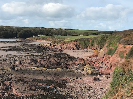
Looking west along the eastern part of Sandy Haven, some 5 km in from the mouth of the waterway.  Red marls and other rocks belonging to the ORS series dominate -- and the clifftop sediments are also predominantly red in colour.


The glaciation of Milford Haven is one of the great neglected topics.  The geological maps show plenty of glacial and fluvioglacial deposits scattered in patches across the landscape, but I am not aware of any comprehensive study.  And it is widely assumed that the glacial deposits that have been mapped are all pre-Devensian and pre-Ipswichian, originally designated "Older Drtift" and more recently assigned to the Wolstonian or Anglian glacial episodes.

In the BGS Memoir relating to "The Country around Milford" (1916) TC Cantrill and his colleagues (including HH Thomas) mention many locations where isolated erratic boulders and Quaternary deposits may be found, but they were not very consistent with their labelling; they used the term "boulder clay" for clay-rich glacial deposits, but many other exposures of till were simply referred to as "gravel", and they did not distinguish between water-lain or fluvioglacial gravels and fine-grained gravelly slope deposits.  We should not be too critical -- the BGS surveyors were working under great pressure, and not one of them was a glacial geomorphologist.  Nonetheless, the Memoirs are invaluable resources, summarising a multitude of field notes.

The Momoir is here:
227 Milford
http://pubs.bgs.ac.uk/publications.html?pubID=B01813


We already know that the LGM Irish Sea Glacier or ice stream entered Milford Haven, since there is fresh till above interglacial sediments at West Angle and till and thick fluvioglacial deposits at Mullock Bridge, not far from Dale.  It's amazing that this evidence is ignored by so many Quaternary scientists even though it is well documented.  They insist on portraying an LGM ice edge somewhere out to the west, sometimes 20 km or more out into St George's Channel.


https://brian-mountainman.blogspot.com/2020/08/the-interglacial-glacial-sequence-at.html
https://brian-mountainman.blogspot.com/2017/02/the-west-angle-enigma.html
https://brian-mountainman.blogspot.com/2017/03/the-west-angle-enigma-2-silt-and-clay.html
https://brian-mountainman.blogspot.com/2017/03/the-west-angle-enigma-3-two-tills-or-one.html
https://brian-mountainman.blogspot.com/2020/08/the-west-angle-sediment-sequence-moreys.html
https://brian-mountainman.blogspot.com/2017/03/west-angle-gallery.html
https://brian-mountainman.blogspot.com/2017/03/west-angle-bay-classic-coastal-section.html

https://brian-mountainman.blogspot.com/2018/08/mullock-bridge-looks-important-again.html

https://www.researchgate.net/publication/229120558_A_Late_Weichselian_kame_terrace_at_Mullock_Bridge_Pembrokeshire

There are also classic exposures of glacial and other sediments at St Bride's Haven, Marloes, and Westdale Bay --  all tying the late Quaternary sediment sequence in with that of St Brides Bay and the coast of North Pembrokeshire.

If Irish Sea ice pressed into the Haven, how far to the east did it extend? Today I managed to get over to Sandy Haven (SM860070) while the sun was shining and the tide was low!  It's "the one that got away"  -- for a variety of reasons I have never examined it properly before, in spite of having walked past it on the Coast Path on many occasions.  The rocks (belonging to the Devonian Milford Haven Group) are predominantly bright red marls and sandstones, but there are also greenish and buff-coloured sandstones and conglomerates exposed along the shoreline.  There are complex structures too, making the 1 km of cliffline somewhat chaotic and interesting, with abundant faults and crossing fractures and little anticlines and gullies everywhere -- but hardly any caves.  The cliffs here are seldom more than 20m high, and rockfalls and slope processes are more significant  than shoreline processes associated with wave action.  This is a much more sheltered coastline than that of the open Atlantic coast to the west.

On the clifftops between Ferry Cottage and the eastern end of the bay, two patches of Devensian sand and gravel are shown, but I think these are periglacial rather than fluvioglacial in origin --  and in a close examination of the cliff exposures I only found one small patch of gravel that I would link with the presence of glacial meltwater.

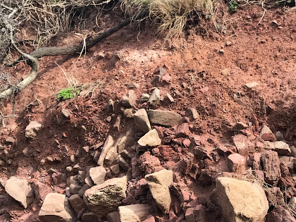
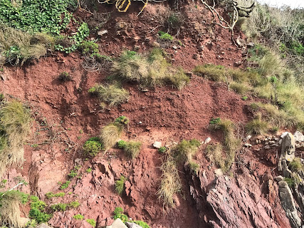
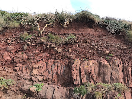
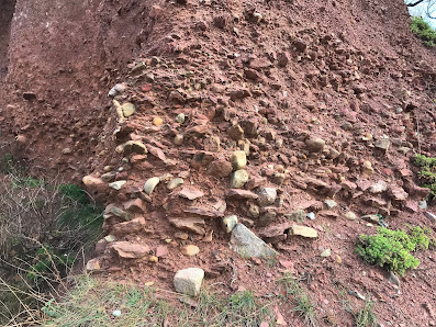
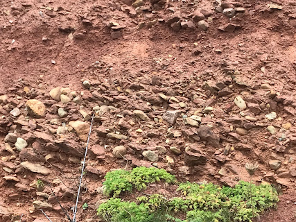
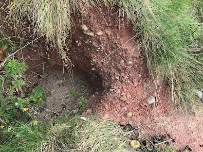
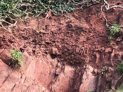
The Quaternary sequence in Sandy Haven is dominated by rockfall debris and slope breccia with so much internal variety that generalisations are hazardous!  The sequence in one place seems to bear no relation to the sequence 20 m away, just around the next corner; I conclude therefore that the relatively steep slope inland of the cliffs has generated complex rockfalls and debris flows over many thousands of years, with the details of downslope stratigraphy determined by the nature of the rock outctops rather than by changes of climate. I may be wrong, but currently I can see nothing consistent in the stratigraphies of the exposures from west to east.  Here are a few glimpses of what can be seen:

To the west of the steps:


To the east of the steps:


It's tempting to correlate some of these layers with the stratified "rearranged till" at West Angle on visual grounds alone, and to match up the buff-coloured colluvium with similar materials at other South Pembrokeshire sites, but I will hold back on that for the time being.

So we have plenty of evidence for a prolonged period dominated by rockfalls,  slope processes and probably a periglacial climate dominated by frost-shattering or breccia production and by downslope debris creep and catastrophic debris flows or slope collapses.  The slope breccia is in some places so "churned" that permafrost processes should be invoked.

"But is there any Devensian till here?  And where is the raised beach at the bottom of the sequence?" I hear you cry......

I was coming to that.
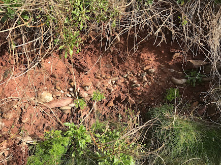
First, the raised beach.    

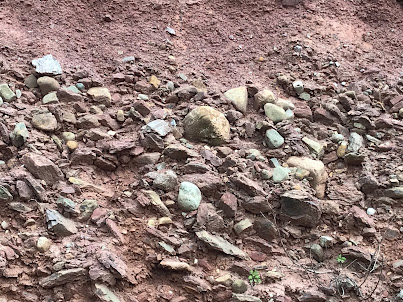
It's exposed in just one locality, in the cliffs near the car park.  We can see it in a very messy exposure, in a sandy deposit dominated by well-rounded pebbles generally less than 10 cm in diameter.  There are many erratic pebbles.  The layer is only about 20 cm thick, and it is not cemented.  It rests on a rough rock platform just out of the reach of storm waves, but it appears to rest on a brecciated layer of red marl fragments, and for this reason I think it is in a secondary position and that the in situ raised beach is hidden behind the exposure face.  Above the raised beach we see about 1m of redddish sandy and gravelly brecciated slope material.


The raised beach at Sandy Haven.  Note the high concentration of rounded pebbles -- probably displaced from their original positions.  The beach rests on a broken surface of red marls. 

Next, the Devensian till.  

This is exposed in several places, mostly around 100m - 80m to the west of the steps. Grid ref SM 859072. There is one large mass of till exposed in a small embayment.  It's at least 4m thick, with a reddish colour and a sandy matrix.  It's packed with rounded, faceted and broken stones and cobbles of all sizes and many rock types -- including some igneous boulders almost 1m in diameter.  This is not a deposit dredged up by overriding ice from an old sea bed -- this is a "land facies" of the Irish Sea till, with its characteristics determined by the nature of the land surface of the south shore of St Bride's Bay.  The ice responsible for this till has travelled for the last 6 km of its journey from the NW across the S Pembs coastal platform.  It is thus very similar in composition to the till studied at Ogof Golchfa on the south shore of the St Davids Peninsula.
https://www.researchgate.net/publication/231973096_The_Pleistocene_Drift_Succession_at_Porth-Clais_Pembrokeshire?ev=prf_pub

The till exposures are very varied and discontinuous.  The base is not seen in the main exposure, but in one locality 1m of till incorporating many slope breccia fragments is seen resting directly on bedrock. The till grades up into about 2m of red flaky gravels, with colluvium and soil above.  In the main exposure the till is overlain by a layer of fine red colluvium about 30 cm thick, with about 1m of stony slope breccia above that.  


Two exposures of the red stony till at Sandy Haven.   Igneous rocks are included in the erratic assemblage, and there are some large igneous boulders on the beach below.


Stony till with abundant local fragments of slope breccia, with a layer of sandy and silty colluvium above, and a layer of slope breccia (upper head) above that.


A small exposure of stony gravels that may be associated with meltwater activity alongside melting ice.


THE STRATIGRAPHY

This is not the easiest site to interpret, and there is nowhere that we can cite as showing a full stratigraphic sequence.  However, piecing it all together it looks like this:

6.  Modern soil
5.  Fine-grained colluvium (aeolian? slope wash?) up to 1m thick
4.  Thin slope breccia generally c 1m thick, incorporating glacial debris
3.  Sandy gravelly till up to 4m thick, incorporating much slope breccia
2.  Slope breccia and colluvial deposits -- many different facies
1.  Raised beach cobbles -- c 20 cms thick (disturbed?)

The precise placing of the till in this sequence is difficult to establish.  Maybe all we should say is that there was a prolonged cold / periglacial episode in which many slope breccias and gravelly deposits were accumulated on an old and complex cliffline, with glacier ice affecting the area for a limited time and incorporating slope breccia, soil and other materials as it flowed over the landscape, probably from the NW.  Glacial deposits were thin and discontinuous.  There may have been somewhat catastrophic ice wastage, with much debris flowage and mixing of deposits.  The till is in any case more like a meltout till than a lodgement till.  Meltwater seems to have played only a minor role in the redistribution of glacial and periglacial materials.  

CONCLUSIONS

1.  There is no doubt that the raised beach (Ipswichian?) does extend inside the mouth of Milford Haven, although it was probably thin since this is not a high-energy storm wave environment.  Its altitude is not much above present HWM.

2. There is no doubt that this bay was affected by glacier ice which probably flowed across an old land surface, from the NW.  This was probably at the time of the LGM, around 26,000 years ago.

3. The fact that there are erratics in the raised beach suggests at least one earlier glacial episode.

4. The glacial deposits at Sandy Haven appear to be stratigraphically related to those at West Angle, Westdale, Marloes and other sites.


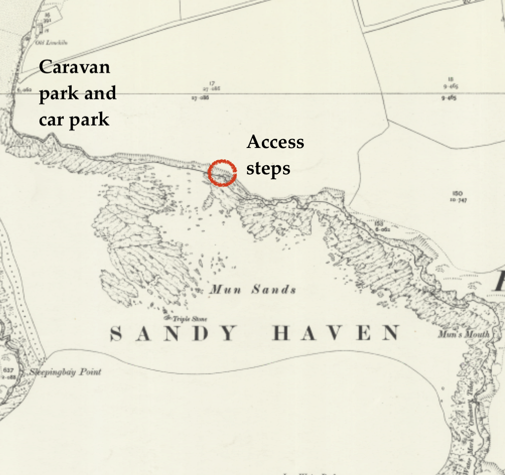
This is the stretch of cliffs examined during my recent visit.  On this old map the location of the caravan site, camping field and car parks have been added.  The crucial exposures are to the west of 
the access steps.  There is a good path from the picnic area and car park to the top of the steps.  This is a part of the Pembrokeshire Coast Path.