THE BOOK
Some of the ideas discussed in this blog are published in my new book called "The Stonehenge Bluestones" -- available by post and through good bookshops everywhere. Bad bookshops might not have it....
To order, click
HERE

Monday, 25 April 2022

Darvill on the Salisbury Plain scatter of bluestone erratiics


The standard question from "glaciation sceptics" is this:
"If ice carried bluestones from west Wales to the Stonehenge neighbourhood, why are there no other bits of bluestone debris anywhere else besides Stonehenge?"

Well, Olwen Williams-Thorpe and her colleagues itemised abundant known occurrences more than 20 years ago, and if you want some info from a senior archaeologist, perhaps Tim Darvill will do.

Here is an extract:

Everybody Must Get Stones
Timothy Darvill
in
Internet Archaeology, Issue 26 (2009). Implement Petrology theme
URL: http://intarch.ac.uk/journal/issue26/6/4.html  May 27 2009

..............there are numerous flakes and chips in what has become known as the Stonehenge Layer right across the interior of the monument (Atkinson 1979, 63-4). Colonel Hawley was astonished to find that bluestone fragments exceeded sarsen by a factor of four to one in the areas he sampled between 1921 and 1926 (Hawley 1921; 1922; 1923; 1924; 1925, 21-2; 1926; 1928). A piece of spotted dolerite was found in the ditch of the Heelstone in 1979, perhaps part of a shaped monolith (Pitts 1982, fig. 25), and more than a dozen pieces of bluestone have been found in the surrounding landscape (see Stone 1948; 1950; Pitts 1982, 125-6; and Thorpe et al. 1991 for lists). Deliberate placement of bluestone chips and fragments with burials, perhaps to help sustain life, are recorded with the Beaker burial in the ditch at Stonehenge and nearby at Amesbury 4 (Engleheart 1932) and Amesbury 51 (Ashbee 1978), while unstratified pieces have been found at three local round barrows: Winterbourne Stoke 28 (Cunnington 1929, 226), Winterbourne Stoke 29 (Cunnington 1884, 143), and Wilsford 35-36e (Hoare 1812, 206).

Beyond the Stonehenge Landscape there are pieces of bluestone scattered across central southern England and these are often assumed to have come direct from the Preseli Hills as part of the 'axe-trade'. In fact most can be more economically explained as souvenirs from the break-up of Stonehenge. The large fragment found by William Cunnington inside the long barrow known as Boles Barrow some 19km to the north-west of Stonehenge is often cited as evidence for the early arrival of spotted dolerite in Wiltshire. As I have argued elsewhere, however, this piece most likely lay within a deliberate blocking deposit within the chamber, a practice common across Britain in the late third millennium cal BC and wholly consistent with the early destruction of Stonehenge (Darvill 2006, 126). The same might apply to the fragment of Group XIII stone in the upper fill of Middle Ditch segment IB at Windmill Hill, which was described by Isobel Smith as 'difficult to interpret as part of an axe' (1979, 19; see also Smith 1965, 114 and Whittle et al. 1999, 340). A piece of rhyolite similar to that in the Bluestone Circle at Stonehenge was found on the top of Silbury Hill during excavations in 1969 (Atkinson 1970, 314; Whittle 1997, 21), and a piece of spotted dolerite found near the West Kennet long barrow (Williams-Thorpe et al. 2004, 373) was perhaps lost en route to the ceremonies that must have accompanied the filling of the chamber at this well-known barrow.

Of course, in the above extract the assumption that all bluestone bits and pieces were transported by humans is adhered to with almost religious conviction by Tim, but no evidence of any kind is brought forward to contradict the hypothesis that many if not all of these fragments were present in the Stonehenge landscape -- and further afield -- well before the Neolithic, and that glacier ice may well have had something to do with it.

West Angle surveyed section: the Quaternary sediment sequence

 The West Angle surveyed section which I have published before -- in slices -- has rather poor resolution, so here it is again.  I hope it will be possible for future researchers of this site to blow this up and extract crucial information from it.  Let's see how we get on........


Click to enlarge.  This survey was done in the late 1960's during many visits, and completed in 1969. 

You can see from this detailed section why david Bowen and others have made mistakes at this site.  For a start, there is so much slumping on the face of the section that large parts of it are obscured for most of the time.  Second, if you are just looking at some random sections where in situ sediments can be seen, you may well see the interglacial slits, clays and peat bed at a higher level than the reddish till, and may assume therefore that the till is older and the interglacial silts younger.  Unless the sediment cliff face around point E is visible during your visit, you might not see the erosional contact between the till and the older deposits at all, and you might also miss the glacitectonic features including slabs of interglacial sediments caught up in the glacial sequence.  If you only see a part of one of these slabs, again you might be misled into thinking that the till is oder than the silts and clays.

All in all, this is the most difficult Quaternary exposure in west Wales to plot and interpret;  no wonder there has been endless confusion......

I think I have got it right, but I'm always prepared to be proved wrong if new evidence should be dug up!

The three key interpretive articles are here:


See also:


There are others too -- please use the search box.


Open access for historic "Nature" article


One of the featured sites -- the kame terrace at Mullock Bridge.  The sample for radiocarbon dating was taken from one of the "shelly" beds


Calcareous uncemented shelly gravels in the Trellys gravel pit, not far from Abermawr, overlain by stratified silts and sands.

Gradually I am placing all of my published glacial geomorphology articles onto the web, using the Researchgate vehicle.  There are still a few gaps, but we will get there........

I wish that Ixer and Bevins are various others would do the same; too many specialist articles are hidden behind paywalls, which means that effective scrutiny becomes impossible except for those who belong to academic institutions or who are prepared to pay £25 (or whatever) for the privilege of reading something.

Anyway, at long last I have managed to upload a crucial paper published in "Nature" in 1965, which caused quite a stir at the time because it was the first article to seriously question the Older Drift /Newer Drift scenario for the western parts of the British Isles, the first article to demonstrate that the South Wales End Moraine of Charlesworth was not actually an end moraine or glacial limit at all, and that the last glaciation of South Wales and Southern Ireland was very recent indeed in geological terms -- namely around 20,000 years ago.  It also used radiocarbon dating evidence from bulk samples, which was bound to be controversial at a time when radiocarbon dating was in its infancy -- but I stuck to my guns on the reliability of the dates because I knew they were supported by the Quaternary stratigraphy.  And as we know, stratigraphy never lies (well, hardly ever.........).

There were some fairly high profile ripostes (in print and in conference discussions) from assorted researchers whose own favourite hypotheses were threatened by my research findings, but by 1968 many other researchers were finding from their research in southern Ireland, the Welsh Borders, North Wales and elsewhere that their glacial deposits were the same age as mine, and that their radiocarbon dates showed that mine were as reliable as theirs.

Ah, happy days!  By the way, Main Wurm = Late Devensian.  Anyway, here is the info:

A Possible Main Wurm Glaciation in West Pembrokeshire
July 1965
Nature 207(4997):622-623
DOI:
10.1038/207622a0
Brian John

https://www.researchgate.net/publication/234477839_A_Possible_Main_Wurm_Glaciation_in_West_Pembrokeshire

Abstract
Two carbon-14 age determinations from marine mollusc fragments in glacial outwash in Pembrokeshire have indicated that the last glaciation of West Wales from the Irish Sea probably occurred within the past 38,000 years. Bulk samples were required by the laboratory, so there were many fragments in each sample; the dates are "aggregate dates" taken from fragments of different (but probably not widely differing) ages. There is no reason to doubt the reliability of the age determinations, which confirm ice-free conditions in the Irish Sea and Cardigan Bay during the middle part of the Wurm glacial episode. The shell samples from Mullock Bridge in south Pembrokeshire and Trellys in north Pembrokeshire indicate a similar interglacial / glacial history at each site. This means that the "South Wales End Moraine" of Charlesworth does not delimit the maximum extent of glacier ice during the last glacial episode. Further, it is suggested that the extent of the Main Wurm Irish Sea Glacier was greater than has been previously assumed, and that the "Older Drift" area incorporates at least some expanses of relatively recent glacial deposits.

------------------

See also:


Abstract
At Cil-maenllwyd (Cardiganshire) glacial outwash sands were found to contain layers of small wood fragments. A radiocarbon age determination of 33,750 yrs B.P. indicates that the wood fragments are probably of Middle Würm age, and that the last glaciation of St. George's Channel occurred during the Main Würm. Pollen and spores contained in the sands suggest that the environment prior to the last glaciation was at one stage predominantly forested. The organic remains are thought to relate to the problematical “ Middle Würm Interstadial ”, rather than the Paudorf Interstadial.


Satellite image.  The sand and gravel quarrying operation at Banc y Warren, as it appears today.  The old Cil-maenllwyd pit was in the SE part of the excavated area, and has now been incorporated into the main quarry.

Saturday, 16 April 2022

West Angle "Nature" article uploaded


I discovered that my pivotal "Nature" article on West Angle, published back in 1968, had a page missing and therefore did not make much sense!  That has now been corrected, and it can be consulted here:

https://www.researchgate.net/publication/232783499_Age_of_Raised_Beach_Deposits_of_Southwestern_Britain

This was one of the first articles to present evidence of a last interglacial sediment suite in Wales containing pollen and other organic remains, and one of the first to argue that the interglacial deposits must be Ipswichian -- and that the red till at West Angle was above the raised beach and was therefore Devensian in age.

Much water has gone under the bridge since then, although for many years DQ Bowen and others confused the issue considerably by erroneously stating that the till lay beneath the raised beach -- simply because they had not examined the coastal exposures carefully. This confusion was repeated in the GCR volume on the Quaternary of Wales, in 1989.  See pp 76-78.  But DQB was one of the editors, so there was, to put it mildly, bias as well as confusion........

-----------------

PS.  The reason why DQB and others got it wrong is that they did not spend enough time here, and did not clean the exposure face adequately.  So they missed the substantial evidence of rafting and the incorporation of large slabs of estuarine interglacial silts and sands into the glacigenic deposits.  There were some complex glacial tectonics here, resulting in a number of "inversions" in which older deposits overlie younger ones.  It's all explained (and illustrated) here:

https://brian-mountainman.blogspot.com/2017/03/west-angle-bay-classic-coastal-section.html

Thursday, 14 April 2022

Pentre Ifan Wood - LIDAR image


Click to enlarge -- high definition

A sign of things to come.  The Pembs Coast National Park has recently commissioned LIDAR imagery of much of North Pembs -- I think the flying was completed in January or February,  So we can expect fantastic imagery to be published before too long -- from which we will be able to extract mammoth quantities of information -- relating to archaeology and geomorphology.

Until now, very little of Pembrokeshire has had LIDAR imaging done.  One small section is published above -- showing Pentre Ifan Wood in extraordinary detail.

Something suspicious is showing up here, at top centre in the image, on the northern edge of the wood, between Trewern on the left and Pentre Ifan Urdd Centre on the right.

I am rather more interested  in the deep channel right in the middle of the wood, that leads nowhere but which has clearly carried water westwards. It has to be a glacial meltwater channel, somewhat like the channels in Tycanol Wood, but it is very inaccessible  -- the vegetation is very thick indeed in the wood, and  proper field research there is almost impossible........

PS. 

Here is the source of the LIDAR material.  You can zoom in on it and get high definition nimages:

https://houseprices.io/lab/lidar/map

Cilgwyn Amphitheatre -- dead ice features


False colour terrain image of the Cilgwyn area, with Carningli to the left and the end of the Cwm Gwaun Channel at the base.

We live in the southern part of the Cilgwyn Amphitheatre, not far from the "entrance" to the Gwm Gwaun meltwater channel,  and having made a few more observations in recent days i am now convinced that this was a location in which a large ice lobe from the north melted away in rather spectacular fashion.   The lobe is shown on the BGS geology map for the Fishguard area; I think is is pretty reliable, although the line does not necessarily show the MAXIMUM extent of Late Devensian ice.


 The map shows Devensian ice pushing some way into the Gwaun Valley, and I don't have a problem with that.  But there must have been a major ice edge stillstand or retreat stage in the area around Tyriet (Bluestone Brewery), Ysgarwen, Brynglas and Penybont, since there is distinct hummocky topography here, with thousands of erratic boulders scattered across the ground surface and incorporated into hedge banks.  The soil is generally clay-rich, and there are areas of waterlogging.  Occasionallyv we see exposures of stony till.

To the north-east of this moraine (which I have called the Cilgwyn Moraine) there are several distinct mounds of sand and gravel which have been referred to as remnants of a kame terrace -- but I do not see a consistent surface level, so they are best referred to kames, probably formed in a series of independent and ephemeral dead ice hollows that were partly filled with meltwater.  The fields where these kames occur are very dry.  I have not seen any clean exposures which might reveal bedding structures and water flow directions.

This area of sandy and gravelly mounds extends northwards past Fachongle Isaf towards Brithdir Mawr, but in and around the incised valley of the Clydach river there are several areas of waterlogging where till is exposed at the surface.  In the field south of Coed y Pwll there is a sharp break between a dry sandy slope (to the south) and a wet area with waterlogging to the north.   On both sides of the road to the south of Ty Rhos there is an undulating till surface -- this is the Coed y Pwll till sheet which has been shown in a water supply borehole to be around 29m thick and which extends to the east of the Clydach river for more than 3 km.  This is classified as Irish Sea till by the BG, and I agree with them --  but because the exposures at Coed y Pwll (adjacent to the pond and the exposed erratic boulder) are several km inland from Newport Bay there appear to be no shell fragments.  The till is very similar in texture to that exposed on the Parrog and at Abermawr; as mentioned in my earlier post, the clay is so clean that it has been exploited in a series of connected claypits that are now lost in the wooded area to the north and west of the cottage.

On the rising slope to the north of Dolbont, on land belonging to Llystyn Farm, the soils become sandier again, and there are several distinct mounds of sand and gravel that can be picked up on the satellite imagery.  Again I interpret these as signs of catastrophic ice wastage at the end of the last glacial episode.

All in all, the assemblage of landforms and sediments in the amphitheatre of Cilgwyn indicate that a lobe of ice was present here, probably wasting away over several centuries in somewhat chaotic circumstances.  The mosaic of different deposits suggests that "anything could happen, and probably did........"  The signs are subtle, but the landscape here is a classic of its kind.

How the meltwater channels in Tycanol Wood, and the features in Pentre Ifan Wood, relate to these sedimentary features is still to be worked out....... but these recent observations show that Glacial Lake Nevern never did exist, and that meltwaters from this ice wastage environment drained away northwards, and not through the Gwaun Valley.   But we knew that already.


Tuesday, 12 April 2022

The Penfro Till Formation -- a geological myth


This is the BGS map of till units in Great Britain; the "minimal till" area (shown in red) to the south of the presumed Devensian limit in Wales is labelled as the "Penfro Till Formation"........

Here we go again. Having expressed my despair, many times on this blog, about the tendency in archaeological circles to accept myths and fantastic speculations as established truths, I have to express my frustration about the same sort of thing happening in geology.

I was looking at the BGS lexicon today, and was very disappointed to see that the entry for the Penfro Till formation is unchanged, in spite of strong concerns about its reliability as a label:

https://brian-mountainman.blogspot.com/2017/02/penfro-till-formation.html
https://brian-mountainman.blogspot.com/2017/02/llandre-gravel-quarry-where-is-penfro.htmlhttps://brian-mountainman.blogspot.com/2019/01/the-curse-of-lithostratigraphy.html


As I have pointed out before on this blog, and in correspondence with the BGS, if we look at the definitive entry for this "ancient till" in the lexicon, under the Albion Glacigenic Group as the "parent unit", we find that the type localities are West Angle Bay and Llandre Quarry in Pembrokeshire. That is an extraordinary error on the part of the geologists, since there is NO ancient till exposed at either site, and the sands and gravels at West Angle are demonstrably Devensian -- and therefore have nothing to do with the Albion Glacigenic Group.

https://brian-mountainman.blogspot.com/2017/03/the-west-angle-enigma-3-two-tills-or-one.html


The critical central part of the West Angle exposure. Here we see the erosional contact between the older deposits (partly interglacial) to the south and the younger (partly glacial) deposits to the north. Dixon, Bowen and others might not have seen this contact clearly, and so they assumed (erroneously) that some glacial deposits are older than the grey silt and clay series.

This is the West Angle stratigraphy:

10. Made ground and soil -- modern
9. Dark red stratified horizon -- late glacial (Devensian / Holocene transition
8. Dark red diamicton (non-stratified) -- Late Devensian glaciation (LGM)
7. Orange silt and clay series -- Ipswichian interglacial dune slack environment (freshwater)
6. Grey silt and clay series -- ditto
5. Peat and peaty silt -- ditto
4. Stony grey silts -- up to 1.5 m thick -- ditto (includes some slope breccia material?)
3. Ferruginous bedded sands and gravels -- up to 1.5 m thick -- Ipswichian shoreline deposits?
2. Rounded pebbles / beach shingle in a sandy and gravelly matrix -- up to 1.8 m thick -- Ipswichian raised beach
1. Sand layer -- more than 1 m thick -- Ipswichian sandy beach

There are admittedly some glaciofluvial gravels at Llandre that might be old, but neither DQB nor anybody else has ever published a full description of them, and there is nothing at the site to tie the gravels into a regional stratigraphic sequence.

Type localities need to be stable, accessible and clearly tied into a regional stratigraphy. Llandre is useless as a type locality for anything; if West Angle is used as a type locality for anything, it should be for the Devensian or the Ipswichian, and most definitely not for the Penfro Formation or the Anglian glaciation.

The error is compounded by reference to Pencoed, where the glacigenic deposits are also assumed (without hard evidence) to be pre-Ipswichian in age.  This is unfortunate, to put it mildly, because in the BGS memoir for the country around Bridgend, written more than 30 years ago, Wilson et al (1990) argue quite strongly that the Ewenny and Pencoed glaciogenic deposits are probably NOT related to the Penfro Till Formation of the Albion Glacigenic Group, but are probably of Late Devensian age.  I tend to agree with them on that, and think it rather strange that within the BGS the right hand appears not to know what the left hand is doing.

Wilson, D, Davies, J R, Fletcher, C J N and Smith,
M. 1990. Geology of the South Wales Coalfield, Part
VI, the country around Bridgend. Memoir of the British
Geological Survey, Sheet 261 and 262 (England and Wales)
Second edition

https://pubs.bgs.ac.uk/publications.html?pubID=B01835

Anyway, I have written yet again to the BGS with a request that the lexicon entry for the Penfro Till Formation should be scrapped -- or at the very least completely rewritten.   Don't hold your breath -- within the BGS things are measured in millions of years........

See also:


ENTWISLE, D C, WILDMAN, G. 2010. Creation of the Till Thematic Layer. British Geological Survey Internal Report, IR/10/041. 14pp.

The correspondents for Wales are shown as David Wilson and Jon Merritt

Sunday, 10 April 2022

Sediment survival on high-energy coasts


Hartland Point (above) and St Davids Head (below):  two high energy coastal environments in which coastal sediments have very little chance of survival.  Those Quaternary sediments that do survive have to be hunted for in narrow valleys and sheltered creeks.


The more I look at my field notes from coastal sections on the shores of the Bristol Channel, the more convinced I become that they all tell the same story, as follows:

8. Colluvium and modern soil development/ peat beds / submerged forest -- Holocene

7. Upper slope breccia -- some evidence of periglacial processes -- Late-glacial

6. Meltout till and glaciofluvial deposits -- LGM ice wastage phase

5. Irish Sea till and local Welsh till -- LGM (late Devensian)

4. Long episode of slope breccia accumulation --cold climate oscillations (mid Devensian)

3. Blown sand / beach sand sediment accumulation (deposits often cemented) - Early Devensian

2. Raised beach pebble beds and gravels -- Last Interglacial (Ipswichian)

1. Introduction of foreign erratics and patchy ancient tills in early glacial episodes

Nothing much has changed since I completed my doctorate thesis in 1965. Am I guilty here of forcing the modern evidence into an ancient and even out-dated  ruling hypothesis?  I think not -- as followers of this blog will know, my ideas have oscillated a lot over the years, and many of my own hypotheses have fallen by the wayside!

Of course, every coastal exposure is unique, and there are many factors in addition to global or northern hemisphere climate oscillations that determine precisely what sediments will accumulate and survive.  So here and there one or two of the above sediment types will be missing -- for reasons that are sometimes glaringly obvious and sometimes obscure.  Sometimes there will be anomalous or unique sediments in locations where special circumstances will have obtained -- for example, in association with sediment groups (5) and (6) there may be varves or pro-glacial lake clays, and in association with group (2) there may be rockfall debris or evidence of exceptional events like tsunamis or coastal barrier breaches.


West Angle Bay, within the MilfordHaven Waterway.  This is a low-energy environment, with an unusual set of Quaternary sediments -- as a result of an estuarine context, mobile dunes and an ephemeral dune slack.

But always the basic stratigraphy shines through, as I have demonstrated on this blog for literally hundreds of sites.  I dare to suggest that this blog now contains the most comprehensive record of coastal sediments in West Wales that has ever been published.  I'm happy that there is a common history and landform development and sediment accumulation as far up the Bristol Channel as a line from Porthcawl to Lynmouth, and as far south as Newquay.  To the east of Lynmouth and to the south of Newquay the evidence of recent (LGM) glacial activity seems to fade away, and is replaced by evidence suggesting that the whole of the Devensian (50,000 years or more) was a time of severe but oscillating cold climate, with relatively unbroken accumulation of slope breccia or "head".    Interestingly, when I checked back through some of the old sources, this is exactly the same scenario identified by Prof Nick Stephens in Fig 11.1 of his chapter in "The Glaciations of Wales and Adjoining Regions" published in 1970.  There is nothing new under the sun..........

When one considers the local variations that do occur from site to site, I suggest that many researchers have failed to take account of one vastly important geomorphological issue -- namely the survival of unconsolidated sediments on high-energy coasts.  There are high energy coasts all around the Bristol Channel, accompanied by a high tidal range, so the amount of ongoing coastal modification is spectacular.  There are rockfalls -- sometimes on a truly spectacular scale -- every winter on the coasts of Pembrokeshire, Carmarthen, Gower, Devon and Cornwall.  Arches collapse and coastal footpaths need to be constantly realigned to cope with damage done by landslides and slumps.  Yes, there are low energy environments (for example in Milford Haven, on the shores of North Gower,  and in the Teifi estuary) but by and large we are dealing with very dynamic situations, and we should not be at all surprised if we find that most of the surviving sediments are geologically very recent (ie less than 100,000 years old) and that most of the older deposits have simply been eroded away without trace.

To some degree this explains why there are complex associations of deposits from several different glaciations in Eastern England and virtually nothing comparable in the Celtic Sea / Bristol Channel arena.  Actually, may suites of significant deposits are present, but they are in deep water and are very difficult to study.  What we have around the edges of these submerged areas are a few scattered traces, and the challenge is to interpret them with a sophisticated understanding of geomorphological and glaciological principles, and with due respect for the landscape settings in which they are found.

------------------

PS.  It seems to me that the coast of Pembrokeshire was comprehensively overwhelmed by the ice of the Irish Sea Glacier or Ice Stream on a number of occasions, with the ice surface well above the summit of Foelcwmcerwyn (536 m) in at least one early glaciation and maybe around 350m (just overtopping Carningli) during the LGM.  

On the other hand the north- and west-facing coasts of Devon and Cornwall, that much further south, were formidable obstacles to the flowing ice.  The cliffed coastline is frequently over 100m high, and steep coastal slopes attain altitudes of over 250m in many places.  Where the Exmoor uplands approach the coast, the coastal slope is more than 300 m high. Although there are many breaches in these coastal ramparts (for example at Padstow and Barnstaple) the eastwards advance of the ice was effectively prevented, and we can envisage a fingered ice edge pressed against the cliffline with occasional incursions inland.  The occurrence of "high-level erratics" shows that during at least one glacial episode the ice was capable of overtopping the coastal slope; but during the LGM I think it most likely that the ice edge coincided with the cliffline -- meaning that almost all of the glacial sediments associated with it have been removed by coastal processes since the sea attained approximately its present day (interglacial) sea level around 7,000 years ago.

As I have explained before, many times, I do not agree with the "conventional" view as expressed by the BRITICE team that the LGM ice edge lay parallel with the Cornish coastline, but maybe 50 km to the west.  The portrayal of the ice edge is associated (in the reconstructions) with ice flowing parallel with with the ice edge.  This is not how glacier ice behaves; there must have been lateral expansion of the ice, since there are no constraining topographic features out in the Celtic Sea.  The ice must have flowed perpendicular to the ice edge, and it must have extended eastwards until it was stopped by the barrier of the Devon-Cornwall cliff-line. 


Above:  three versions of the map published in many publications by members of the BRITICE Chrono team over the past few years.  In each version the LGM ice limit is shown to the west of the Devon-Cornwall coast, on the basis of very little evidence.  The evidence now seems to show that the ice edge lay along the cliffline, but further research is needed to ascertain whether ice flow was then parallel with the cliffline or perpendicular to it.  


It is much more likely that the LGM ice edge was as shown on this map, with Lundy and the Scilly archipelago exposed as nunataks surrounded by thin but active ice.  This map is somewhat dated -- I now think that mid and south Pembrokeshire were ice covered, and that the eastward limit of Irish Sea ice at the time lay approximately between Porthcawl and Lynmouth.


This annotated satellite image from near the ice sheet edge in East Greenland is an excellent illustration of what the Isles of Scilly archipelago might have looked like at the time of the LGM.  There is no merit in other reconstructions that "force" the ice edge around onto the western flank of the islands, with an ice-free channel between the islands and the Cornish coast.


Friday, 8 April 2022

The ability to knowledgeably question....


 There has been a lot of discussion on social media over the past few days on the "prophecies" of Carl Sagan.  I am not sure that he actually prophesised anything -- but he certainly had the ability to pick up on trends and identify a direction of travel.

I merely put this quote here so that we can all remind ourselves that there is a great difference between "what feels good" and "what is true."  And that those of us who are reasonably qualified to do so should without fail scrutinize the things that we are asked to accept or believe.


Thursday, 7 April 2022

Trebetherick revisited


When I was a student, back in the Stone Age, I went on a field trip that included a visit to look at the Trebetherick boulder bed (or "boulder gravel") and thought that it was self-evidently a till.  But at that time tills were not supposed to occur so far south, and the deposit was explained away as something else.......

Anyway, the site has been discussed in a multitude of research papers and book chapters, and still confuses people.

Here are some attempts at explanations:

The Arkell paper:

 https://pdfslide.net/reader/f/the-pleistocene-rocks-at-trebetherick-point-north-cornwall-their-interpretation

THE PROBLEM OF THE NATURE, ORIGIN AND STRATIGRAPHICAL POSITION OF THE TREBETHERICK BOULDER GRAVEL

by B. B. Clarke

Abstract. The small patch of gravel within the head of the Camel estuary near Trebetherick Point (sx 927781 is described, and various suggestions about its origin reviewed. It is believed to have originated as a till left by the south Irish Sea Riss ice sheet, and suffered frost heaving and solifluction to its present site during three phases of the Würm.

http://ussher.org.uk/wp-content/uploads/2021/01/PUS_1969.pdf

See also p 288 of the 1970 volume on"The Glaciations of Wales" and the section devoted to Trebetherick Point by Campbell on p 184 of the GCR volume on SW England (1998).  James Scourse has considerd the si5te in a number of publications.

To quote Clarke:

It is 2 m thick, thinning rapidly both ways, and only 50 m in lateral extent. It consists of pebbles and boulders up to 300 mm across. Most are roughly rounded, a few angular, and a few well rounded and water worn. They rarely touch and are set in a matrix of bright orange clay. The gravel differs from the local head in the colour of the matrix, and the rarity of slate except at the margins, and from the present day beach gravel in the clay matrix, the rarity of flint and the abundance of granite. The most striking feature is the junction with the three heads. There is a zone of interpenetration in each case although the heads are believed to be of different ages. Many of the stones in the boulder gravel are from local quartz veins and elvans but there are also many granites, one of which may be from Lundy, quartzites, indurated shales, flints, one foliated granite which shows a much higher grade of metamorphism than belongs to this area, and a number of unidentified igneous rocks.


Most of the literature on Trebetherick is taken up with rather sterile arguments attempting to sort out the lithostratigraphy and with attempts to fit the various layers of sediment into pre-existing schemes of glacial and interglacial episodes.  There is no great merit in trying to summarise all of that.  

But two points are critical in any modern assessment:

1.  Following the work by James Scourse and other members of the BRITICE Chrono team, it is now well established that the Late Devensian Irish Sea Ice Stream extended far to the south of the Cornish coast, meaning that nobody should be surprised if actual glacial deposits from the LGM should be found on the coast in favourable locations.

2.  It is inescapable that the Trebetherick "boulder bed" was emplaced above an erosional contact with the slope breccia (otherwise referred to as the "lower head" or "main head") and that it is younger than both the raised beach and the sandrock / beachrock which is everywhere associated with it.

So the boulder bed is in exactly the same stratigraphic position as the Late Devensian till in the Isles of Scilly, all around the coasts of West Wales and on the Gower Peninsula.  If the deposit really is a "remobilised" or "recycled" deposit from some ancient glaciation, if would be an extraordinary coincidence for it to have been slid into precisely this position in a complex suite of deposits, and nowhere else.

The conclusion has to be that the boulder bed is a genuine Late Devensian glacial deposit emplaced here by the same ice stream that affected the Isles of Scilly.  It may have been subjected to some remobilisation and redistribution shortly after original emplacement, but that would be par for the course,  and should surprise nobody.  That is what happens to almost all glacial deposits in ice-marginal situations.

Wednesday, 6 April 2022

The "sterile blue clay" and possible glacial deposits at Westward Ho


Peat beds underlain by stony blue clay at Westward Ho.  Looks familiar.........

At Westward Ho there is a Pleistocene sequence resting on a spectacular raised beach on the shoreline, and also a "Holocene sequence" exposed occasionally on the foreshore.

There are lots of records of a "sterile blue clay" underneath a Mesolithic midden and a peat bed and submerged forest layer on the foreshore.  According to Prof Nick Stephens in the 1970 "Glaciations of Wales" volume (p 285) the clay grades up to an upper clay layer containing pollen and other organic remains, and beneath it there is a blocky breccia presumably derived from bedrock outcrops. Balaam et al, writing in 1987, referred to the underlying material as "drift" -- and that term has of course always been used for materials of glacial origin.   Stephens also suggests that the clay is underlain in places by beach cobbles and boulders, and that where a surface is visible there are signs of a "rough polygonal pattern" indicative of a permafrost environment.

It's more than a little confusing, but there are obvious similarities with Amroth, Marros, Freshwater West and other sites on the south Pembrokeshire coast where exposures of the submerged forest are occasionally exposed.

Here we find a list of publications that mention the blue clay:

 https://www.heritagegateway.org.uk/gateway/Results_Single.aspx?uid=MDV44568&resourceID=104

There is also a section by Stewart Campbell in the GCR volume for South-West England -- on p 224.

So could the sterile blue clay be a till deposited on the shoreline by glacial ice coming from the west or the north?  More investigations are clearly needed......

But there is another interesting comment in Prof Stephens's book chapter, where he refers to an "upper head" deposit in cliff sections at Westward Ho which contains "some pebbles derived from a till" which he sees as a probably the equivalent of the Fremington till found just a few miles away.  He describes no coherent till, but the occurrence of the erratics in a distinct slope breccia layer above the "lower head" suggests a close similarity with Abermawr and many other Pembrokeshire coastal locations where a coherent till layer is present in the same stratigraphic position.  Stratigraphy, in general, does not lie -- and we need to consider the possibility that there might be a late Devensian (or maybe older) till somewhere in the vicinity, redeposited or rearranged as at Ragwen Point (see my recent post).

On the Westward Ho cobble ridge:

https://studylib.net/doc/8383073/westward-ho--cobble-ridge

The origin of the ridge is not known, although Keene (1996) regards it as a comparatively recent feature. Hall (1879) described a peat and blue clay deposit about 400 m seawards of the cobble ridge and Rogers (1908) recorded remnants of former forest, a kitchen midden and a submerged pebble ridge in the intertidal area. The peat contained leaves, seeds and fruits ofiris, oak Quercus, hazel Corylus, alder Alnus, elder Sambucus, sea aster Aster tripolium,common orache Atriplex patula, blackberry Rubus, dogwood Cornus and lesser spearwort Ranunculus flammula. Shells of oyster Ostrea and limpets Patella were also recorded. The blue clays were reported to include flint flakes (thought to be Neolithic in age), small pebbles and angular fragments of Carboniferous rocks. The mud-snail Hydrobia ulvae was common and bones were said to include red deer Cervus elephas, and Celtic shorthorn cattle Bos longifrons. Since most of the sediment disappeared before modern interpretation and dating techniques were available, the records have to be taken as a possible indication that the cobble ridge lay seawards of the position of the submerged forest and that the land behind it was well colonized by vegetation. The similarity with the development of the cobble ridges at Clarach and Ynyslas on the Welsh coast (see Figure 8.15) may indicate a much earlier age (about 4000 years BP) for Westward Ho!. In contrast to summer depths of sand on the western beach of up to 1.2 m, erosion during the winter of 1983–1984 exposed a thick band of head, suggesting that a wide apron of periglacial debris may have extended some distance seawards of the present-day shoreline (Keene, 1996) and this may provide an alternative explanation for the location of the submerged forest. Erosion of such deposits would provide the source for a transgressing postglacial beach. Samples from the top of the peat bed were radiocarbon dated to 6585 ± 120year BP (Q-672; Churchill and Wymer, 1985) and 4995 ± 105 years BP (Kidson, 1977). The Holocene sequence is described in detail by Campbell (1998) following description of inner and outer peats by Balaam et al. (1987) which indicates that the outer peat was inundated by marine/estuarine conditions about 5200 years BP.


Extracted from the Geological Conservation Review

You can view an introduction to this volume at http://www.jncc.gov.uk/page-2731© JNCC 1980–2007 Volume 28: Coastal Geomorphology of Great Britain 

Chapter 6: Gravel and ‘shingle' beaches – GCR site reportsSite: WESTWARD HO! COBBLE RIDGE (GCR ID: 2110)3

More work is needed here........

Irish Sea Glacier - Welsh ice interactions at the Last Glacial Maximum


This is from my post of the other day.  I thought it would be more accessible as a post in its own right. 

https://brian-mountainman.blogspot.com/2022/04/the-late-devensian-glaciation-of.html 

The map represents my latest hypothesis. It seems to me to be based on quite sound evidence, much of which has been presented and analysed on this blog. 

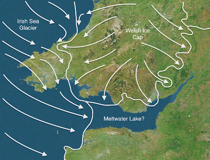
Suggested Late Devensian relationship between Irish Sea ice and Welsh ice:

In the contact zone between the two ice masses there must have been a southwards diversion of ice streams. There must also have been considerable shifts in the ice contact position, associated with sharp changes in the ice movement directions. Most of the South Pembrokeshire coast is shown as being affected by Irish Sea ice, which must at some stages have flowed more or less west to east. The ice cover over central and south Pembrokeshire might have been rather thin. Swansea Bay was affected mostly by a powerful ice stream made up of ice flowing in the Nedd and Tawe valleys -- but at one time Irish Sea Ice might have dominated, possibly reaching Pencoed and Porthcawl. The maximum extent of the Irish Sea ice might have been c 30 km further east than shown.  Gower is shown as completely submerged beneath Welsh ice, but at some stages the south coast might have been affected by Irish Sea Ice. The igneous "giant erratic" found in Limeslade Bay, near Mumbles, might have been emplaced in the Devensian.  Mynydd Preseli might have had its own local ice cap in the waxing and waning phases of the glaciation. In Carmarthen Bay there was a conflict between Irish Sea ice coming from the west and Welsh ice flowing via the Tywi and other valleys.

The fantasy of Glacial Lake Nevern

The glacial lakes assumed (by the BRITICE team) to have existed in NE Pembrokeshire and the Teifi Valley.  There is good evidence for "Glacial Lake Teifi" in the published literature, even though its outlines may not have coincided with those shown here -- but "Glacial Lake Nevern" is pure fantasy, dreamed up almost a century ago, and it should have no place in a supposedly scientific research document.


Last night I was checking out some of the features mapped on the BRITICE Chrono map of Devensian features in the British Isles -- which is flagged up as THE definitive map.   I was amazed to find that the version currently available on the web still shows "Glacial Lake Nevern" -- a feature that has not a scrap of evidence in support of it, as many of us have been pointing out for half a century or more. There are no shorelines, no rafted deposits, no varved lake clays or other sediments, no moraines marking the position of an ice dam, and no evidence of any sort relating even to a short-lived body of standing water that covered the area proposed.  In short, Glacial Lake Nevern was a fantasy from the beginning, dreamed up by Charlesworth because he was obsessed with glacial lakes and overflow channels..........

On the map, the lake is shown as covering Cilgwyn, Felindre Farchog, Crosswell, Brynberian, Penygroes and the whole of the low-lying area on the north flank of Mynydd Preseli, with an outlet or "overflow" into Cwm Gwaun.  

This is quite extraordinary.  How is it that Chris Clark and his colleagues in the supposedly high powered BRITICE team have simply perpetrated a myth that is a century old in a publication that is supposed to represent all the latest sophisticated science?  Don't ask me what the answer is -- ask them! 

It's rather sad, after all my criticisms of archaeologists for the perpetration of assorted bluestone myths including the human transport myth, the quarrying myth and the lost circle myth, that I now have to accept that in my own field -- glacial geomorphology -- there are other myths almost a century old that are still being flagged up in spite of the vast accumulation of evidence showing that they are speculative and even nonsensical.

All that having been said, there is limited evidence for meltwater lake clays on Brynberian Moor, and I have discussed the likely extent of "Glacial Lake Brynberian" as a short-lived feature associated with ice wastage and ice edge retreat northwards down a reverse slope.  There might have been one lake a few kilometres long, or a series of short-lived smaller lakes impounded by detached masses of wasting glacier ice.  Such short-lived lakes might have existed in multiple locations during the catastrophic melting of the LGM ice in West Wales.

====================

See this:

Sunday, 26 November 2017

BRITICE Glacial Map 2 -- a mixed blessing


This is what I said:

The outlines of Glacial Lake Teifi more or less coincide with what we see in assorted published papers, but the other information shown on the map is very scanty indeed for the Cardigan - Moylgrove area. That must disappoint many of the authors who have published their research findings, with considerable local detail on the record. When we zoom in on Preseli and the hypothetical area of "Lake Nevern" we find even more problems. Why is "Lake Nevern" shown at all? So far as I am aware, nobody since Charlesworth in 1929 has taken it at all seriously, and many papers by a variety of authors have shown that the "evidence" for it does not withstand scrutiny. The paper authors site "George 1970"as their source of information, but George was simply citing (very uncritically) Charlesworth, and provided no evidence for this so-called lake. Careless. As readers of this blog will know, there are a few places where thin laminated (lake?) sediments appear to be present on the northern flank of Preseli, but they are better explained by short-lived ponding of meltwaters in complex terrain in a dead-ice environment. I have called this "Lake Brynberian" -- a possible small lake of limited duration and extent. There are other fluvioglacial landforms and moraines in this area which are in the literature. They should have been mapped, but have not been. And where did that impounded lake at Pontfaen come from? I am aware of no evidence in support of it.

https://brian-mountainman.blogspot.co.uk/2015/05/lake-brynberian-further-thoughts.html

The impression is gained that this map has been produced by researchers accessing satellite and bibliographic data and sitting in front of computer screens, unlike the BGS bedrock and sedimentary map for the UK which has been based largely upon the field notes of surveyors working in the field. Black mark for BRITICE, and glowing praise for the BGS. In the abstract to the paper, the authors state: "All published geomorphological evidence pertinent to the behaviour of the ice sheet is included, up to the census date of December 2015." That is patently not true. There are abundant references in the literature (just a few of them by me, and many others as well) that have clearly not been consulted.

The explanation of how the "glacial lake" information was added to the map:


BRITICE Glacial Map, version 2: a map and GIS database of glacial landforms of the last British–Irish Ice Sheet
Chris D. Clark, Jeremy C. Ely, Sarah L. Greenwood, et al
Boreas: 29 August 2017
https://doi.org/10.1111/bor.12273

The cited lake evidence used by the BRITICE researchers is said to have come from this source:

https://www.sciencedirect.com/science/article/abs/pii/S1040618211004320?via%3Dihub

Quaternary International
Volume 260, 18 May 2012, Pages 115-142

Middle and Late Pleistocene glacial lakes of lowland Britain and the southern North Sea Basin

Della K.Murton and Julian B.Murton

........ and their source was TN George, in the British Regional Geology of 1970, who in turn cited Charlesworth's 1929 paper on the South Wales End-moraine.  At no stage in this process of citations of older work was any critical scrutiny applied, as I noted in the following blog post:

Tunnel valleys in the Celtic Sea


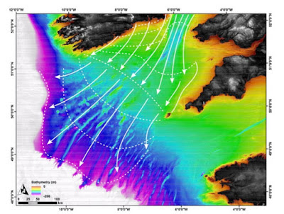
Tunnel valleys and other features showing a Late Devensian radiating ice flow in the Celtic Sea arena

This is another interesting article relating to the wastage phase of the Celtic Sea ice lobe -- or that part of the Irish Sea Ice Stream that occupied the Celtic Sea out as far as the shelf edge around 27,000 years ago.  This study of fluvioglacial features supports the concept of a catastrophic ice melt episode across the whole extent of the area shown on the above map in just a few thousand years.

I have considered the position of the eastern edge of the wasting "ice lobe" before:


https://brian-mountainman.blogspot.com/2020/04/the-devensian-celtic-sea-piedmont-lobe.html


......but there still seems to be a reluctance on the part of those involved in the BRITICE Chrono project to accept that ice flows according to a rather basic set of glaciological principles, including the principle that ice lobes will always spread laterally unless they are constrained by topography or by an adjacent ice mass.  Do here, once again, we see a reluctance to accept that the Isles of Scilly were effectively a nunatak with ice flowing broadly southwards on both the western and eastern flanks -- in spite of rather clear evidence of seafloor streamlining between Scilly and the tip of Cornwall.  Why should there be a problem with this?

Associated with this is the assumption that the outer part of the Bristol Channel was not affected by LGM ice.  Where did this idea come from?  Well, it came from some very old articles purporting to show that only the north coast of Pembrokeshire was affected by Late Devensian ice, in spite of the fact that I showed many years ago that the ice of the Irish Sea Glacier affected the mouth of Milford Haven at the same time.  If it did that, the ice must also have pressed into the outer reaches of the Bristol Channel, if not into the area to the south of the Gower Peninsula.  This is of course confirmed by all the evidence which I have collected over the last few years relating to glacial sediments around the south Pembrokeshire coast, including the published evidence from Ballum's Bay on Caldey Island.


If you look at the alignments of the tunnel valleys and other channels on the map above, the pattern is indubitably one that shows a radiation pattern of ice flow -- exactly what one would expect, and exactly what I have been arguing for the last 50 years or more............

With regard to the black line on the map purporting to show the ice edge at 25,000 years ago, it is not supported by any field evidence, and I suspect that the eassetrn part of the line is in quite the wrong place -- it should be much further to the east.  The purported ice edges for 24.7 ka and 24.3 ka might be more accurate,  and are supported to some extent by cosmogenic dating work.  

--------------------------


A Late Pleistocene channelized subglacial meltwater system on the Atlantic continental shelf south of Ireland.

Giglio, C., Benetti, S., Sacchetti, F., Lockhart, E., Hughes Clarke, Giglio, C., Benetti, S., Sacchetti, F., Lockhart, E., Hughes Clarke, J., Plets, R., Van Landeghem, K., O Cofaigh, C., Scourse, J. & Dunlop, P.  

Boreas, 2022 (January), Vol. 51, pp. 118–135.

https://doi.org/10.1111/bor.12536

ABSTRACT

The studyof palaeo-glacial landforms and sediments can give insights into the nature and dynamics of ice sheets. This is particularly the case with regards to the subglacial record, which is challenging to observe in contemporary glaciated settings and hence remains only partially understood. The subglacial hydrological system is an essential component of ice dynamics, where increased water pressure enhances ice motion and sediment deformation, thus reducing ice-bed contact. Tunnel valleys are large, sinuous, steep-sided incisions that, together with smaller scale meltwater channels, indicate subglacial meltwater discharge beneath large ice sheets. Through the use of high-resolution marine geophysical data, a system of buried and exposed tunnel valleys, possible subglacial or proglacial meltwater channels and palaeo-fluvial valleys have been identified across the shelf of the Celtic Sea between Ireland and Britain. The presence of steep-sided and overdeepened tunnel valleys is indicative of a large channelized meltwater drainage system beneath the former Irish Sea Ice Stream, the most extensive ice stream to drain the last British–Irish Ice Sheet. After the rapid ice expansion across the Celtic Sea shelf around 28–26 ka, the tunnel valleys were carved into both bedrock and glacigenic sediments and are associated with rapid ice stream retreat northwards into the Irish Sea Basin between 25.6and 24.3 ka. The presence of a major subglacial meltwater system on the relatively shallow shelf suggests that significant erosive meltwater discharge occurred during the last deglaciation and highlights the important contribution of meltwater to the retreat of the British–Irish Ice Sheet on the continental shelf. 

Tuesday, 5 April 2022

Was there a late Welsh Ice cap advance following the LGM?


The study area on the SE coast of Ireland

This is an interesting and rather specialised paper which describes a late expansion of the Irish Ice Cap on the coast of southern Ireland, following the wastage and ice-edge retreat of the Irish Sea Glacier.  On the coast of Ardmore Bay, at the time of the LGM, Irish Sea ice travelled from the east towards the west.  However, following ice retreat into what is now the offshore zone, Irish ice expanded, with some of it flowing in precisely the opposite direction.  A little further to the east, there was a 90 degree change in the direction of ice flow, with Irish ice from the Midlands flowing southwards towards a snout position more than 20 km offshore. 

What happened on the west side of St George's Channel may well also have happened on the east side......

 There is evidence of a late Welsh ice advance in North Wales, but the evidence from Cardigan Bay and the South Wales coast is more equivocal.  Indeed, the evidence from New Quay and elsewhere suggests that there might have been a "Welsh" glacial phase, with ice from the Welsh ice cap flowing out across the coastline, BEFORE the maximum extent of the Irish Sea Glacier, but not afterwards.  All very confusing.  Watch this space.......

 ==========================

Geomorphological and seismostratigraphic evidence for multidirectional polyphase glaciation of the northern Celtic Sea

Zsuzsanna Tóth, Stephen Gerard McCarron, Andrew James Wheeler, Volkhard Spiess et al

February 2020

JOURNAL OF QUATERNARY SCIENCE (2020) 1–14JOURNAL OF ,e of the LGFM a=SCIENCE (2020) 1–JOURNAL OF QUATERNARY SCIENCE (2020) 1–14

DOI:
10.1002/jqs.3189


Abstract

High‐resolution seismic and bathymetric data offshore southeast Ireland and LIDaR data in County Waterford are presented that partially overlap previous studies. The observed Quaternary stratigraphic succession offshore southeast Ireland (between Dungarvan and Kilmore Quay) records a sequence of depositional and erosional events that supports regional glacial models derived from nearby coastal sediment stratigraphies and landforms. A regionally widespread, acoustically massive facies interpreted as the ‘Irish Sea Till’ infills an uneven, channelized bedrock surface overlying irregular mounds and deposits in bedrock lows that are probably earlier Pleistocene diamicts. The till is truncated and overlain by a thin, stratified facies, suggesting the development of a regional palaeolake following ice recession of the Irish Sea Ice Stream. A north–south oriented seabed ridge to the north is interpreted as an esker, representing southward flowing subglacial drainage associated with a restricted ice sheet advance of the Irish Ice Sheet onto the Celtic Sea shelf. Onshore topographic data reveal streamlined bedforms that corroborate a southerly advance of ice onto the shelf across County Waterford. The combined evidence supports previous palaeoglaciological models. Significantly, for the first time, this study defines a southern limit for a Late Midlandian Irish Ice Sheet advance onto the Celtic Sea shelf.

Monday, 4 April 2022

The Late Devensian glaciation of Carmarthen Bay


Ragwen Point, near Pendine.  Blue-grey diamicton made predominantly of clay and silt, with small fragments of shales and mudstones and sandstone blocks derived from pre-existing slope breccia. It's at beach level, and it is clearly in a secondary position, having flowed / slid downslope from its original position.   Interpreted as a local Late Devensian till laid down by Irish Sea ice flowing west to east along the old cliffline at Ragwen Point.


Multiple opinions about the extent of Late Devensian ice across South Wales

Having been collection field evidence from here and there over past weeks, I am now convinced that I have got it all wrong in the past with regard to the LGM in west Wales. Everybody else has got it wrong too. A reminder of the multitude of suggestions in the specialist literature, arising out of a too-easy acceptance of the Older Drift - Younger Drift ruling hypothesis and out of the sheer difficulty of interpreting the field evidence in central and southern Pembrokeshire. The evidence is not that easy to interpret in north Pembrokeshire either!!

Having argued for years in favour of a substantial unglaciated enclave across much of southern Pembrokeshire, I am having to confront the fact that every time I visit the South Pembs coast, I come away with evidence of quite recent glaciation, or at the very least, evidence that shows the same stratigraphy -- and hence the same sequence of events -- as the coasts of north Pembrokeshire and St Bride's Bay.

South Pembrokeshire

So now we have evidence of sticky blue clay with faceted and abraded erratic pebbles beneath the offshore peat beds and submerged forest at Freshwater West, Amroth, Marros and Pendine. There are blocky slope breccia materials in the clay as well, but I cannot think of any better explanation for it, other than to say that it is a till carried and deposited by glacier ice travelling from the west towards the east. We have fresh clifftop till at scores of locations along the south Pembrokeshire cliffline. The erratics at Flimston, Loveston and many other sites on the south Pembrokeshire coastal plateau are suggestive of ice that has travelled overland broadly from the NW towards the SE (but admittedly these erratics might have been carried and emplaced in an earlier glaciation). We have the red uncemented till at Ballum's Bay on Caldey Island which I insist must be of LGM age. (In this I differ from Prof John Hiemstra and colleagues at Swansea University, who claim that it is a redistributed ancient till.) Inland, we have apparently fresh fluvio-glacial gravels at Picton Point, at the confluence of the two Cleddau branches, and sticky clay till at Landshipping. We have scattered till patches and fluvio-glacial materials in many locations across south Pembrokeshire, as confirmed by the field geologists of the Geological Survey. And my recent discovery of sticky blue-grey till in the exposures at Ragwen Point again suggests eastwards-travelling ice, and pushes the Late Devensian ice limit much further east than any other worker has ever suggested.

To summarise the Pembrokeshire evidence:

1. There are far too many spreads of glacial and fluvio-glacial deposits in those parts of Pembs deemed to be outside the LGM limit. Some of them, at least, appear quite fresh, and some even have surface expression. They are by mo means all "degraded or denuded" and are by no means restricted to hilltops or interfluves, as claimed by some.

2. The glacial deposits in the valleys and on the clifftops of South Pembrokeshire are so abundant and so fresh that they have to be Devensian. The exposures are itemised on this blog. I now think that there are glacial deposits around  Marros and Pendine as well; and these are best explained by ice pushing in from the west and the north, and not from the south.

3. The glacial and fluvioglacial deposits around Picton Point and Landshipping, right in the centre of the county at the confluence of the two Cleddau rivers, cannot adequately be explained without invoking a complete ice cover across Pembrokeshire. I have another report of fresh till near Haverfordwest.

4. Over and again I have described on this blog glacial deposits and apparent trimlines at a variety of altitudes on the northern side of Preseli, up to an altitude of 340m. It looks to me as if that was the altitude of the highest Devensian ice surface associated with Irish Sea ice. If the ice covered Carn Ingli and pressed onto the northern flank of the Preseli ridge at that altitude, it would make no sense for the ice edge to be at or near present sea level around the mid and south Pembrokeshire coast. Ice must have filled the Cwm Gwaun depression, and indeed I have described apparent morainic features above and on the south side of the meltwater channel, and at Cilgwyn and Tafarn y Bwlch. Nor does it make any sense for an ice edge to be parked around the 200m contour in the vicinity of Wolfscastle and Letterston, as suggested by the BGS. If the ice was coming in from the NW, it MUST have inundated the whole of Pembrokeshire to the south of Preseli, according to the laws of ice physics. The ice edge might have been slightly lower on the southern flank of the Preseli ridge. I now think that the assorted morainic ridges and glaciofluvial mounds in and around the Preseli uplands may be associated with retreat stages or short-lived readvances -- still to be defined.

None of this eliminates the possibility that there are Anglian or Wolstonian glacial and meltwater deposits in the area previously designated as an ice-free enclave. As indicated on this blog, I think there are ancient glacial deposits at Ceibwr, Witches Cauldron and Black Mixen, Lydstep; and Prof Danny McCarroll and I are rather convinced that glaciofluvial gravels exposed at Llangolman may well be very old indeed.

https://brian-mountainman.blogspot.com/2019/07/caldey-island-till-must-be-late.html

The South Pembrokeshire Quaternary regional stratigraphy (based on my own observations and those of Dixon and Leach) is as follows:

8. Sandy loam and blown sand
7. Upper head (uncemented)
6. Fluvioglacial sands and gravels -- traces
5. Till from Dewisland (Devensian) glaciation -- many coastal exposures
4c. Lower head (cemented in some localities)
4b. Cemented sands (sandrock)
4a. Head incorporating raised beach cobbles (cemented)
3. Cemented raised beach
2. Older glacial deposits -- mostly destroyed, but exposed at Lydstep (Black Mixen)
1. Raised beach platform (complex modifications over several interglacials?)

The Gower Peninsula

What of the other evidence from Carmarthen Bay and the Gower?   There seems to be an emerging consensus:

https://brian-mountainman.blogspot.com/2018/11/the-glaciations-of-gower.html

1. There are not multiple interglacial raised beaches on Gower, as suggested by DQ Bowen, but one raised beach which is sometimes cemented and sometimes not, and which occurs at a range of different altitudes depending on precise locations on peninsulas, in bayheads etc. The beach always contains well rounded pebbles and in some places it is very rich in shell fragments and even complete shells. It's dated to the last (Ipswichian) interglacial.  

2. There is plenty of evidence of a prolonged periglacial episode following the formation of the interglacial raised beach, since here and there we see many metres of pseudo-stratified slope deposits or "head" above the raised beach and beneath the glacial and fluvioglacial materials. (This is exactly the sequence we see in Pembrokeshire.) Sometimes the head is cemented, and sometimes not.  The slope breccia must have accumulated during the Early and Middle Devensian.

3. The glacial sediments exposed in the cliffs at Rotherslade, Horton and elsewhere are not ancient deposits moved into place by periglacial and slope deposits, but fresh materials emplaced at or very near a Late Devensian ice edge, with chaotic and even catastrophic flowing and emplacement of till and mixed fluvioglacial materials at a time of rapid ice wastage.

4. The Paviland Moraine near Horton, which was interpreted by DQ Bowen as well beyond the Devensian ice margin (and hence a very ancient glacial feature) contains material which is no more ancient than any of the other glacial and fluvioglacial materials exposed in the cliffs. It should therefore be re-interpreted as a Late Devensian feature -- deposited maybe during a long ice edge stillstand at this position, on a ridge not far from the southernmost tip of Gower.

Traces of terminal moraine loops in Swansea Bay, interpreted as evidence of very powerful ice from confluent valley glaciers or ice streams pushing out into the Bristol Channel lowlands during the Late Devensian


The West Glamorgan coast

As far as the east coast of Swansea Bay and the Vale of Glamorgan are concerned, there has been a consensus over many years that there was a Late Devensian ice edge near Porthcawl.  It has been assumed that this ice edge was associated with Welsh ice flowing southwards from the Welsh Ice Cap; but this has been called into question by Wilson et al in the new Geological Survey Memoir following a re-examination of the evidence from Ewenny and Pencoed, and the erratics of the Storrie Collection.


The authors of the new Memoir suggest that the deposits around Ewenny might well be Late Devensian rather than Anglian in age -- and if this is accepted, then the famous erratics from the west might have been emplaced by the eastward-flowing ice of the Irish Sea Glacier.  The recent discovery of a giant erratic at Limeslade, near Mumbles, and the discoveries of granite and other far-travelled erratics on the south coast of Gower tends to reinforce the idea that the ice of the Devensian Irish Sea Glacier was powerful enough to intermittently affect the south Wales coast in multiple locations.  How the junction between Welsh ice and Irish Sea ice oscillated over time still has to be worked out........... 

Discussion:  was there an ice-free enclave?

I have published versions of this map several times.  If we now accept that there are fresh glacial deposits in the Amroth - Marros - Pendine area, we are left with in ice-free enclave (completely surrounded by glacier ice) which is glaciologically vanishingly unlikely. this is not, after all, an area of complex high relief --mid and south Pembrokeshire is an undulating lowland with incised river valleys that slopes gradually southwards from the Mynydd Preseli foothills.  Ice must maintain a sloping profile in an area like this from source area towards snout.  For Irish Sea ice to have affected the coast of Carmarthen Bay, the WHOLE of Pembrokeshire must have been inundated.


Note the suggested ice-free enclave.  I no longer think
 that this idea is tenable......
 
There are still many questions to be answered, but it seems to me that the time is ripe for a reappraisal of how extensive the ice cover of South Wales was in Late Devensian time, and which areas might have been affected by Irish Sea ice.  My main suggestion (as of today) is that there was no ice-free enclave in Pembrokeshire. There is just not enough evidence to support it.

By removing the ice-free enclave and accepting that all of Pembrokeshire was covered by glacier ice (which may not have been very thick) we come to a map that looks something like this:


One recent attempt to portray the extent of Late Devensian glacier ice across South Wales.  New evidence suggests that this meeds to be modified further..... 

So, to move on.......

The map below represents my latest hypothesis.  It seems to me to be based on quite sound evidence.  I hope that others may now be willing to join the discussion!


Suggested Late Devensian relationship between Irish Sea ice and Welsh ice.  In the contact zone between the two ice masses there must have been a southwards diversion of ice streams.  There must also have been considerable shifts in the ice contact position, associated with sharp changes in the ice movement directions.  Most of the South Pembrokeshire coast is shown as being affected by Irish Sea ice, which must at some stages have flowed more or less west to east.  The ice cover over central and south Pembrokeshire might have been rather thin.  Swansea Bay was affected mostly by a powerful ice stream made up of ice flowing in the Nedd and Tawe valleys -- but at one time Irish Sea Ice might have dominated, possibly reaching Pencoed and Porthcawl.  Gower is shown as completely submerged beneath Welsh ice, but at some stages the south coast might have been affected by Irish Sea Ice.  Mynydd Presely might have had its own local ice cap in the waxing and waning phases of the glaciation.  In Carmarthen Bay there was a conflict between Irish Sea ice coming from the west and Welsh ice flowing via the Tywi and other valleys.