
Whitesands South --Ice-moulded raised beach platform, just above HWM, currently emerging as the drift cliff is undercut and eroded during storm events. This is very similar in appearance to the ice-moulded surfaces seen at Gwbert at the mouth of the Teifi Estuary, and at Parrog, Newport.

Large well-rounded erratic (igneous) boulders now exposed at the base of a section at Whitesands South. They rest on the rock platform and are solidly embedded in the cemented and stained brecciated deposits at the base of the drift sequence.

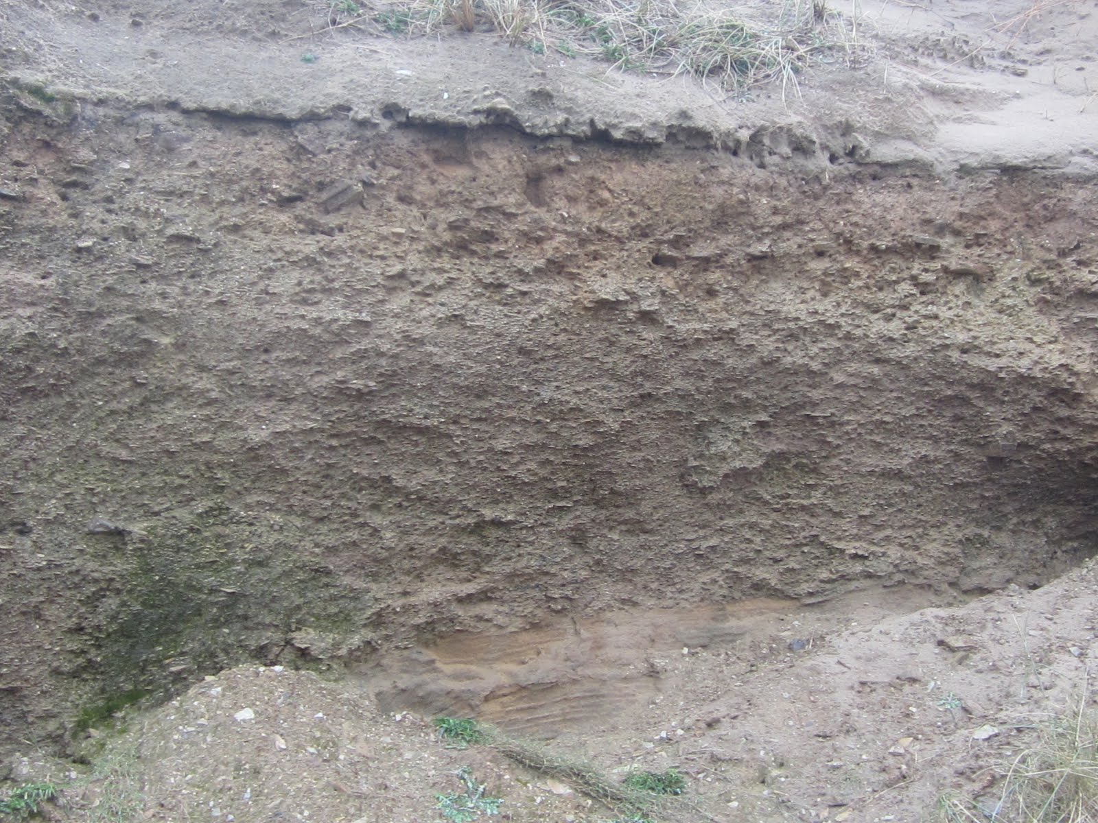
Whitesands South. Higher remnant of the raised beach platform, showing at the base, disturbed (frost churned?) slope breccia c 60 cm thick, with many angular bedrock fragments, rounded and faceted cobbles, stained with reddish iron oxide cement. Above that, a pseudo-stratified layer (up to 1 m thick) of slope breccia with cobbles and lenses of sandrock, stained with manganese oxide cement. Above that, to the left of the image, a wedge of sandrock c 1m in thickness. Above that, c 1m of rubble drift with many angular bedrock fragments, equivalent to the "mobilised" or redeposited till to the north of the car park. Above that, blown sand up to 4m thick, belonging to the modern sand dune system. To the left and right of this image, the boulder bed is seen to be embedded in the lowest stained breccias, resting on bedrock.
Whitesands South. At the base of this photo, modern slope collapse debris partly obscures a layer (c 1m thick) of stratified sandrock. Above that, c 2m of stratified slope breccia with erratic inclusions. This grades upwards (no sharp contact) into a sandy matrix-supported "rubble drift" with a greater percentage of faceted erratics. At the top of this layer, a lag concentrate of broken or brecciated slabs from which fines have neen washed out. Above that, blown sands belonging to the modern dune system.
9. Modern soil
8. Blown sand -- up to 5m thick, best observed to the south of the car park.
7. Upper stratified and brecciated slope deposit -- periglacial in origin? Up to 50 cm thick, but occurring only where adjacent rock outcrops and slopes could provide debris.
6B. Irish Sea till -- upper facies with sandy and gravelly matrix -- remobilised, meltout till and flowtill? Up to 4m thick
6A. Irish Sea till -- lower facies, massive clay-rich till with some glaciotectonic structures -- up to 2m thick. Currently only visible to the north of the car park
5. Lower brecciated slope deposits -- up to 2m thick, containing many erratics. Periglacial phase?
4. Stratified sandrock, up to 2m thick. Some iron oxide staining.
3B. Brecciated cemented layer with erratics and lenses of sandrock -- stained with manganese oxide
3A. Brecciated cemented layer incorporating boulder bed of large rounded erratics -- stained with iron oxide cement
2. Boulder bed -- last traces of a raised beach from which finer materials have been washed out?
1. Ice-moulded raised beach platform
This is a complex and comprehensive sequence of deposits which tells a long story. It ties in very well (as it should!) with the drift sequences exposed in other North Pembrokeshire sites such as Porth Clais and Abermawr. No raise beach sediments are currently exposed, but I should not be at all surprised if they do appear somewhere in the future, following a severe storm or cliff face fall.
There is clear evidence here of two glacial episodes.
OLDER GLACIAL. The earlier one (Anglian?) must have introduced the abundant boulders found in the boulder bed and maybe also many of those found on the foreshore. We can also deduce that the ice moulding on the rock platform which passes beneath the sediments must also have occurred during this early glacial episode.
LAST INTERGLACIAL. The rounding of these boulders must have occurred during a prolonged interglacial period during which sea-level was near, but a little higher than that of today. At some stage the finer materials must have been stripped away, again possibly as a result of wave action. Later, following a drop of sea level, the boulders were surrounded and enveloped in slope breccias where slope conditions were appropriate. As these breccias accumulated (by normal rockfall processes -- I do not think we need to assume the presence of periglacial conditions) more arid conditions may have favoured the introduction of the sand lenses we see in layer 3B. The overlying sandrock must also be assigned to this interglacial period (Ipswichian?).
NEWER GLACIAL. The events of the last (Devensian) Glaciation are much easier to discern, suggesting a cold (periglacial) episode followed by full glacial conditions during which ice arrived from the north-west or north, depositing the clay-rich Irish Sea till and the more sandy and gravelly "rubble drift" suggestive of remobilisation, flow till or ice wastage conditions. There are no true glacio-fluvial deposits here, but meltwater must clearly have played a role in the deposition of layer 6B.
PRESENT INTERGLACIAL. Above that, following the wastage and disappearance of the ice, there was another periglacial phase (short-lived?) followed by a more prolonged episode of blown sand accumulation, giving rise to the present-day extensive area of dunes in and on the flanks of the Whitesands Valley.
A long and interesting history, told through the exposures that are all easily accessible from the beach.
No comments:
Post a Comment
Please leave your message here