Timing of glacial retreat in the Wicklow Mountains, Ireland, conditioned by glacier size and topography
Tomkins, M. et al
Journal of Quaternary Science · November 2017
Journal of Quaternary Science · November 2017
DOI: 10.1002/jqs.3040
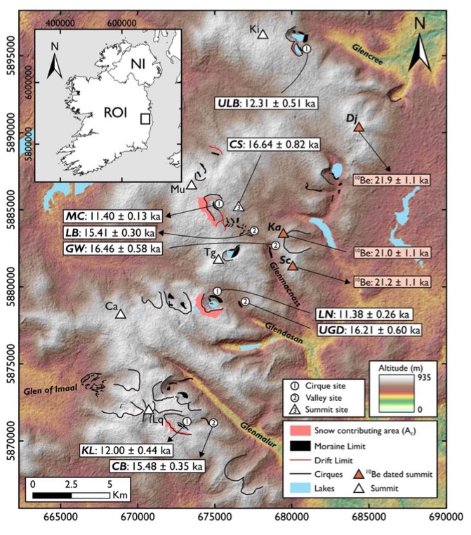
Reconstructing the deglacial history of palaeo‐glaciers provides vital information on retreat processes, information which can inform predictions of the future behaviour of many of the world's glaciers. On this basis, this paper presents 170 Schmidt Hammer exposure ages from moraine boulders and glacially sculpted bedrock to reveal the post‐Last Glacial Maximum (LGM) history of the Wicklow Mountains, Ireland. These data suggest that large ice masses survived for 4–7 ka after retreat of the Irish Sea Ice Stream and were sustained by summit ice fields until ∼16.6 ka. Post‐LGM retreat was driven by climate and involved numerous short‐term ice front oscillations (≤1 ka), with widespread moraine deposition during Heinrich Stadial 1. In contrast, marked asynchroneity in the timing of Younger Dryas deglaciation is closely linked to snow redistribution which demonstrates the sensitivity of small cirque glaciers (≤1 km2) to local topography. This result has important implications for palaeoclimate reconstructions as cirque glacier dynamics may be (at least partly) decoupled from climate. This is further complicated by post‐depositional processes which can result in moraine ages (e.g. 10Be) which post‐date retreat. Future palaeoclimate studies should prioritize cirques where snow‐contributing areas are small and where post‐depositional disturbance of moraines is limited.
This study provides the first comprehensive glacial retreat history for the Wicklow Mountains, Ireland. 170 Schmidt Hammer exposure ages from cirque and valley moraines and from a summit overridden by ice at the LGM demonstrate that significant ice masses persisted for 4-7 ka after retreat of the Irish Sea Ice Steam and were sustained by summit ice-fields until ~16.6 ka. Post-LGM
retreat involved numerous oscillations of glacier termini during the retreat phase, with widespread
moraine deposition related to stabilisation or re-advance of valley glaciers during the Oldest Dryas,
potentially in response to cooling during Heinrich Stadial 1 (HS1). However, these moraines reflect
short-term oscillations (≤ 1 ka) of the ice front during the long-term retreat phase (~8 ka), which
was driven by reduced moisture availability and winter aridity. These data match numerical ages
(10Be, 36Cl, 14C) from comparable mountains caps at the margins of the Irish Sea basin and in SW
Ireland which support a model of widespread and persistent alpine glaciation during the post-LGM
period. Significant ice masses (Length: ≤ 5 km) were present until the onset of Greenland Interstadial
1 and in some mountain massifs, for up to ~4 ka after initial summit emergence following the LGM.
Valley glacier retreat in the Wicklow Mountains was driven by climate, with time-progressive
deglaciation from low to high elevation (R2 = 0.9116). In contrast, marked asynchroneity in the
timing of Younger Dryas (YD) deglaciation (11.4 - 12.3 ka), unrelated to site elevation, latitude or
equilibrium line altitude (ELA), is accounted for by macro-topography and the redistribution of snow
and avalanche material, sufficient to locally supress the ‘local’ (non-climatic) ELA and promote glacier survival. Contrasting synchroneity in the timing of glacial retreat during these periods is conditioned by glacier size, with small YD glaciers (< 1 km2) highly sensitive to local topographic controls. This result has important implications for palaeoclimate reconstructions based on dating of cirque moraines (e.g. 10Be, SHED), as cirque glacier dynamics may be (at least partly) decoupled from climate. This is further complicated by post-depositional processes which can result in ages which post-date retreat. As a result, future palaeoclimate reconstructions should prioritise cirques where snow and avalanche contributing areas (Ac) are small and where the potential for post-depositional disturbance is limited (matrix-poor, boulder rich moraines).
===================

The maximum model of BRITICE 2008 does show an ice mass that waxes and wanes several times, over several thousands of years, over the Wicklow Hills. This time slice is for 16.65 ka. Note that small ice masses are shown in North Wales -- but no ice mass anywhere in south or west Wales.
What interests me in particular is not so much the details and causes of the ice edge retreat patterns, but the conclusion (which seems to be pretty well based) that after the melting back of the Irish Sea ice stream local glaciers and snowfields survived (and indeed were quite healthy) for up to 7,000 years. They advanced and retreated a number of times, not always in synchroneity, but responding to local climatic and snow accumulation conditions. Modelling has of course shown this for all of the upland areas on the fringes of the Irish Sea Ice Stream, but it's good to see some more ground truthing.

The Preseli ice cap -- modelled by Lee, Patton and others -- and assumed to have existed around the peak of the Devensian glacial episide, when ice pressed down from the NW. But did the little ice cap expand and continue in existence for thousands of years after the retreat of the Irish sea ice?
One now needs to think some more about the Preseli ice cap -- how big was it after the retreat of the Irish Sea ice from the Pembrokeshire uplands, and how did it behave? Up until now, there has been an assumption that these small local ice caps developed in the waxing phase of the Devensian glaciation, but that the wastafe phase was so catastrophic that the little ice caps may not have had a chance to regenerate. This new work challenges that assumption........
The other thing about which I am intrigued is the use of the Schmidt Hammer to assess the "exposure ages" of rock surfaces freed of an ice cover. This Wicklow Hills work has been done in a granite area. I wonder if the technique works in an area of dolerites and rhyolites? Watch this space.

How does the Schmidt hammer work in determining exposure age? Surely it is only giving a figure for the 'strength' of the rock which must be the result of many other factors. I suppose a survey would indicate a range of results for rocks which be similar or dissimilar to a greater or lesser amount, but surely this is governed by the geological origin of the material.
ReplyDeleteOr do you find similar rocks and then show that there is some differnce between them.
Dave
Phil will probably know! Maybe this is an essential quarryma's tool......... As I understand it, granite is perfect because the surface actually rots away during exposure to the atmosphere, sunlight and water. Salt too, I assume. The end product is the grus that we see in many granite landscapes. I assume that the original fresh and hard surface gradually softens over time, and that somebody has worked out a calibrated scale for how this translates into "exposure age"........ have written to one of the authors of the paper, to find out more.
ReplyDelete.... quarryman ------- but maybe Phil's mother was into quarrying too.......
ReplyDeleteThat's an odd looking scale on the Schmidt hammer (got one in the cupboard). It does determine strength but surface strength might be degraded by exposure (though I guess that would depend on the type of rock)
ReplyDeleteWas in Wicklow week before last. From Arklow (which is low down) you can see Snowdon on a clear day (looks like a ship I'm told) so should be easy to see the top of the Wicklow hills if you go up to Preseli mountains.
PS something about your site has changed. Can't post using a blogger account.
Jon
Jon -- lucky I spotted this one! Most Anon posts get spammed......... No, I haven't touched anything. But I suspect Blogger is up to something at the moment, following lots of complaints. I am still not getting Email notifications of comments when they come in. Hope it all settles down again........
ReplyDelete