THE BOOK
Some of the ideas discussed in this blog are published in my new book called "The Stonehenge Bluestones" -- available by post and through good bookshops everywhere. Bad bookshops might not have it....
To order, click
HERE

Thursday, 12 October 2023

Valley glacier terminal moraines


Another fabulous image from Mike Beauregard. The loops of moraine formed by small valley glaciers are very spectacular -- they are located to the east of Dexterity Fjord in Northern Baffin Island.  The small glaciers have retreated several hundred metres from their advanced positions -- fifty years ago apparently all of these glacier snouts were located at the terminal moraine positions.

https://www.flickr.com/photos/31856336@N03/7048837663/

Here is a Bing satellite image showing the same valley in summer:


In this image, north is at the bottom of the photo.


Raised beach ridges, Southampton Island


This is a gorgeous photo of raised beach ridges on Southampton Island in Arctic Canada.  They are picked out by a thin covering of winter snow.  Photo credit:  Mike Beauregard.

This is one of the areas of highest isostatic recovery rates on planet Earth -- the marine limit on the coasts of Hudson Bay is in places over 300m, and on the Arctic islands occasionally over 200m.......

Wednesday, 11 October 2023

6,600 reads for Waun Mawn scrutiny paper


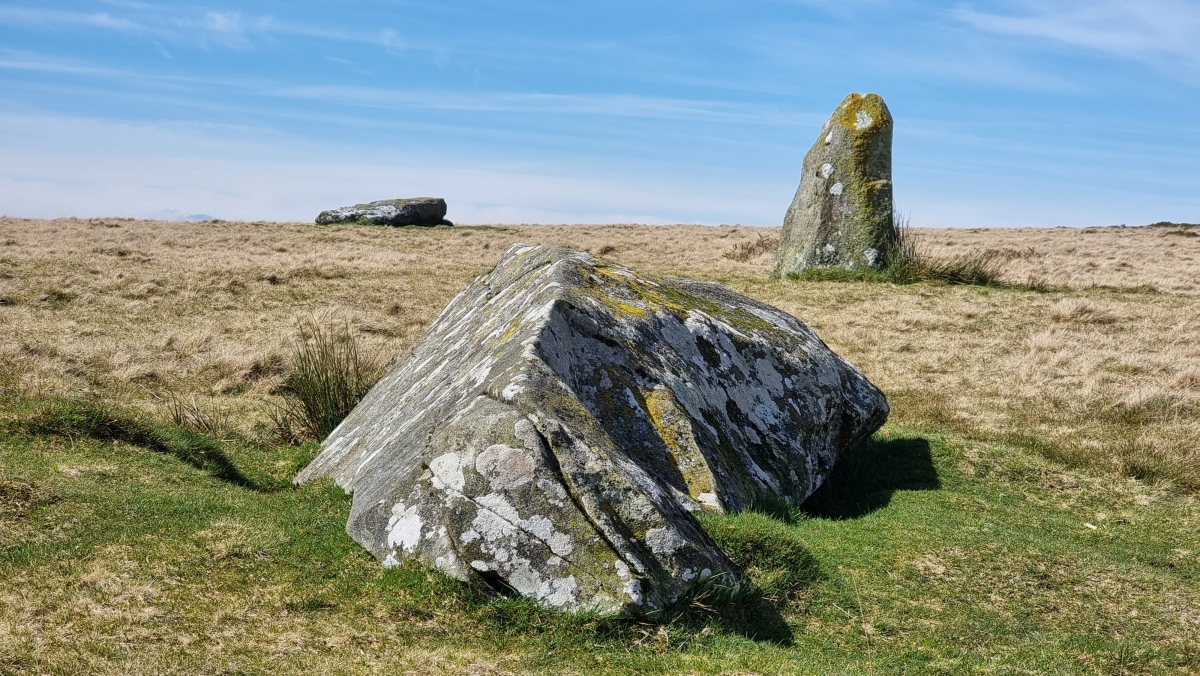
Waun Mawn -- one standing stone and two recumbent.  Photo credit: Horatio

I noticed that the reads for my Waun Mawn paper -- first written in 2021 and revised since then in Sept 2022 -- have now gone over the 6,600 mark.  That's remarkable, and it means that the article is being read by a great number of archaeologists who are less than convinced by the complex narrative woven by MPP on the telly and in other media.

Truth will out, and I will soon do another update to take account of recent research.  Of course, the research team which did the excavation and associated lab analyses for Waun Mawn have already been forced to go on the record and acknowledge that their original speculations and pronouncements were -- shall we say -- premature and indeed foolhardy.  

https://www.researchgate.net/publication/345177590_Waun_Mawn_and_the_search_for_Proto-_Stonehenge

Of course, this article of mine is not peer reviewed in the conventional sense, and might be deemed to be less reliable than it might have been. Fair enough.  On the other hand, as readers of this blog will know, many researchers now have a somewhat jaundiced view of the peer review process, which is often corrupt.  Reviews are often biased and at best subjective, and I have learnt over many years that reviewers can sometimes tell us more about their own belief systems than about the merits or demerits of the document in front of them!  But reviewing is a thankless task, and I sympathise with editors who nowadays find it very difficult indeed to find reviewers ready to tackle even the most significant of submitted articles, let alone the worthy but boring ones that hardly anybody is ever going to read.

I wouldn't mind betting that if my Waun Mawn article had been published in a journal, it would not have had anything like the same number of reads from specialists and non-specialists........ 

The Rudston Monolith


Thanks to Tony for drawing my attention to some recent coverage of the Rudston Monolith in Yorkshire, with the usual guff about human transport..........

This is what Wikipedia says:

The stone is slender, with two large flat faces. It is approximately 5 feet 9 inches (1.75 m) wide and just under 3 feet 3 inches (1 m) thick. The top appears to have broken off the stone. If pointed, the stone would originally have stood about 28 feet (8.5 m). In 1773 the stone was capped in lead; this was later removed, though the stone is currently capped.The weight is estimated at 40 tonnes.The monolith is made of gritstone. The nearest source for the stone (Cayton or Cornelian Bay) is 9.9 miles (16 km) north of the site, although it may have been brought naturally to the site as a glacial erratic. The monument dates to the Late Neolithic or Early Bronze Age.  A possible fossilised dinosaur footprint is said to be on one side of the stone, though a study by English Heritage in 2015 concluded that the claim was unsubstantiated. There is one other smaller stone, of the same type, in the churchyard, which was once situated near the large stone.
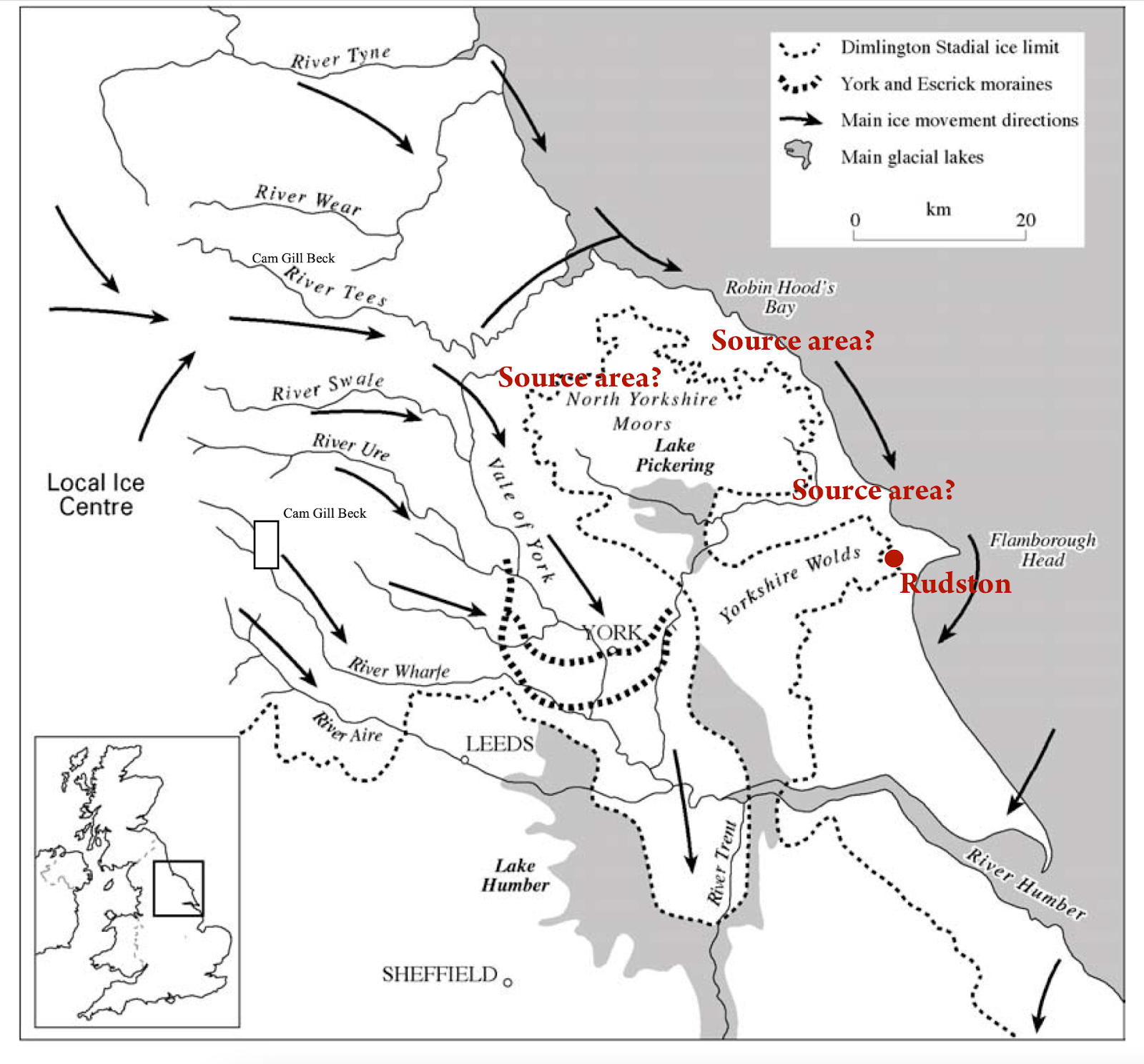
I don't know of any detailed provenancing work on the monolith, but it is apparently a gritstone similar to that outcropping in Cayton Bay and Cornelian Bay to the north.  Southward transport of erratics by the flowing ice on the eastern flank of the British and Irish Ice Sheet would be entirely in line with what we know about ice movement directions:


Erratic transport during the Devensian Glaciation is quite possible, but the consensus seems to be that the greatest phase of erratic transport was during the Anglian glacial episode, around 450,000 years ago.  I have seen some speculation that the Rudston Monolith might have come from the Whitby area, or even from the Clevelend Hills.  Quite possible.

Many people have remarked on the slender and delicate shape of the monolith, and have speculated that it cannot possibly have been transported by ice without being broken into smaller blocks. That's a fair point -- and of course there are similarities with some of the slim elongated spotted dolerite bluestone monoliths at Stonehenge. 


Bluestone 69 at Stonehenge.  Very delicate -- and greatly modified by dressing.....

There's a debate to be had on this, and indeed we have discussed glacier entrainment and englacial transport before on this blog.  Extremely long and thin pillars are in some ways anomalies or survivors which should have been broken -- and that is true no matter what the transport mechanisms might have been -- involving either glaciers or human beings.

Wednesday, 4 October 2023

LRB podcasts -- what is Stonehenge all about?


There are 4 interesting podcasts made by the London Review of Books -- available on Spotify.  Led by Rosemary Hill.  

The 4 programmes are about the changing views of Stonehenge down through the ages.   I haven't yet listened to all of them......  will report back if I manage to complete the task........

https://open.spotify.com/show/5qp7xVVpV5lavnMcm0zMN1


The raised beach at Westward Ho!


The raised beach near Seafield House, at Westward Ho!  Photo: Paul Berry

I have been looking at some of the very interesting posts on Paul Berry's blog, and came across this one, about Westward Ho!

https://devongeography.wordpress.com/2022/05/25/exploring-the-coastal-geography-of-westward-ho-north-devon/

The photo above struck me immediately as a quite precise match for Abermawr in West Wales, where we also see an ancient high level raised beach overlain by thick slope deposits of "head".  The deposits rest on an old rock platform at c 8 m OD -- about 6 m above the level of thye present tidal platform.  According to Stewart Campbell in the GCR Review volume (1998) the massive raised beach made of boulders and cobbles is up to 3m thick, and in the upper metre or so the raised beach material is frost-shattered, indicating the onset of a period of periglacial climate which culminated in the accumulation of a 1m layer of slope deposits. According to some workers the materials are erratic-free, but Prof Nick Stephens recorded erratics in the overlying "sandy clay with stones" -- and he was convinced that these were derived from glacial deposits in the immediate vicinity.

Another view of the raised beach, from Southwestcoastphotos.com -- taken by David Evans.


This is truly one of the most spectacular photos of a raised beach that I have ever seen!

Quote:

A view from the grassy meadow west of Seafield House (1885) - Westward Ho!.
Beach deposits of mainly Culm sandstone cobbles in a sandy matrix lying on an ancient wave cut platform 
Left high and dry when sea levels fell 125,000 years ago.
Covered with head from the period 10,000 - 100,000 years ago when periglacial conditions -
freeze / thaw cycles caused the rock to fragment into a layer of angular stones and small debris.
Ref: 3209
Date: 27/04/2016
Location: SS 4203 2903


The Westward Ho! Pleistocene sequence, from the GCR Review volume, p 225

For comparison:


The raised beach at Porth Killier, St Agnes, Isles of Scilly, resting on an irregular granite surface and overlain by a thin till (?) with erratics


Remnants of a raised beach (storm beach) resting on a high rock platform at Abermawr in Pembrokeshire

See also:


Tuesday, 3 October 2023

Glacial traces near Baggy Point, Devon


The high-level Ramson Cliff epidiorite erratic (photo:  Paul Berry, published on his blog)


Close-up showing the crystalline structure of the epidiorite erratic (photo:  Paul Berry)

Grateful thanks to Paul Madgett and Paul Berry for the following info. 

 I have published some material from PM  before, in 2019, in a post concentrating on the "high level erratic" at Ramson Cliff:

That boulder (altitude c 80m)  is not the only "high-level erratic" on Baggy Point. I know of two others, though smaller - both now on top of the stone wall to the south of Croyde Hoe Farm, and adjacent to the higher footpath/track along the south side of Baggy. Can supply images, if required. Both are tuffs/agglomerates; one a grey almost square block, the other smaller, more irregularly shaped, of a pinkish tinge. Neither were there in the 1970s, and seem to have appeared in the late 1980s or early 1990s. Formerly Croyde Hoe Farm had been mainly arable, and the fields produced regular "crops" of flint tools and waste flakes. In 1969 the farmer, a Mr Bagster, had shown us his collection after we asked permission to walk over his land, and subsequently one of his workmen has allowed me to photograph samples from his personal collection, mostly Mesolithic, but including Neolithic, Bronze Age artefacts, and even a squared-off flint from a flint-lock rifle, all found on Baggy. In the 1990s the new National Trust tenant farmer went over entirely to sheep, so the fields are ploughed only rarely nowadays.

Thus my guess is that the former farmer, knowing of the interest in his land by geologists, and recognising these cobbles / small boulders as "different", having ploughed them up, then placed them in a prominent position for others to see. Neither have the appearance of ex-beach boulders, and I would suggest that they represent the residuum of a former cover of till, now virtually all eroded, most of the boulders once emplaced higher on the coastal landscape now being incorporated into beach deposits, some incorporated in the base of the Raised Beach, as with the Saunton Red Granite (hence any putative glaciation to emplace the boulders needing to be pre-Ipswichian).

I don't have any further details from Paul M, but from the OS maps it looks as if one of these smaller erratics is at around 200 ft (60 m) and the other at around 150 ft (45 m).

Here is another quote, this time from Paul Berry (Oct 27, 2021) in an interesting blog article on the Baggy Point footpath:

About halfway along the north side of Baggy, there is another (smaller) glacial erratic sat right next to the path. It is a 500 kg block of epidiorite of Scottish origin. It is a little difficult to spot, as it is surrounded by gorse, and is slowly disappearing into the surface. Part of the surface has been chipped away, exposing the obvious crystalline structure of igneous rock. It once stood upright in the middle of a nearby pasture field and was used as rubbing post by sheep and cattle. In the early 1970s, the field was ploughed and the rock dislodged and then laid prone. It was then dragged to edge of field where it has been ever since. The erratic can be located at grid reference SS 4356 4070.

Paul B also says:
Other small erratics (tuffs/agglomerates) have been ploughed up nearby and incorporated into the stone wall by the higher path, but they are tough to spot under the dense cover of grey lichen. One is a grey almost square block, another smaller, more irregular shape of pinkish tinge.

https://devongeography.wordpress.com/2021/10/18/take-a-stroll-to-the-baggy-point-erratic/

Paul Berry was Head of Geography and Assistant Vice Principal at South Molton Community College, North Devon.


The famous Baggy Point giant erratic (photo: Paul Berry), on the rocky foreshore


See also:
https://www.geographysouthwest.co.uk/wp-content/uploads/2021/10/PTV-Baggy-Point-Erratic.pdf
https://brian-mountainman.blogspot.com/2022/03/the-baggy-point-giant-erratic.html

Big erratics at 80 m, 60 m and 45 m altitude cannot be explained as dropstones or ice-rafted boulders, and they must represent the last remnants of ancient glacial deposits laid down by an ice incursion from the Bristol Channel during an extensive glaciation. Like the boulders at Whitesands and other locations on the Pembrokeshire coast, some of the Devon erratics on the current foreshore appear to be "sealed" beneath sandrock and Devensian slope deposits; others are "free", having been released from the coastal sediment sequence by wave action and coastal retreat.

Campbell and Gilbert, in the GCR volume for SW England in 1998, p 220, found it difficult to accept that the Ramson Cliff erratic was found originally at c 80m above sea level.  They suggested that it might have been hauled up from the shore to "act as a boundary marker."  In my view that makes no sense at all.  It's not a convenient pillar-shaped monolith suitable for use as a boundary marker -- it's a rough block.  And if the locals wanted a boundary marker stone at some point in the distant past, they could have extracted one from the rock outcrop (marked on the OS maps) on the clifftop nearby.