THE BOOK
Some of the ideas discussed in this blog are published in my new book called "The Stonehenge Bluestones" -- available by post and through good bookshops everywhere. Bad bookshops might not have it....
To order, click
HERE

Friday, 4 March 2022

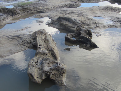
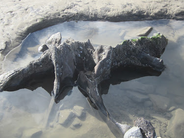
Amroth submerged forest after the storms


A 6m long tree trunk currently exposed on the foreshore at Amroth

After the recent storms, at extreme low tide today on the Amroth foreshore, a vast area of the submerged forest peat beds -- around 200m x 300m -- was exposed.  Tree trunks, branches, roots and peaty beds everywhere -- but no giant elk antlers, unfortunately........  Anyway, herewith a selection of images:


Unfortunately it was very difficult today to find any sections where the stratigraphy was revealed -- since the storms occurred, sand has been washing back into the cuttings, and everything was waterlogged anyway. But I was able to see the stony layer and the blue clay here and there, and can confirm that in places the peat bed is less than 10 cm thick.


And now for something completely outrageous.........


Once upon a time......

I heard this one the other day, and since it is completely outrageous (like all the best jokes) I could not resist repeating it.  Indeed, I would be failing in my duty if I did not.  So here goes.....

=================

Once upon a time, in a country not very far away and in a time not so far into the future, a brain surgeon was looking for a new brain for one of his patients.  So he went into a brain shop to check out what was currently available.

"Ah yes," said the brain monger.  "We have a reasonable stock at the moment.  This one here, for example, is a nuclear physicist's brain, a snip at £50.  Then we have a very nice poet's brain on special offer, for just £100.  And over here we have, at the top of our range, an archaeologist's brain for a cool £1,000........."

What?" exclaimed the brain surgeon.  "You must be joking!"

"Not at all, my dear sir," came the reply.  "It's as good as new.  In fact, completely unused......"

================

Complaints -- on a postcard please -- should be sent to the Society of Antiquaries.

Thursday, 3 March 2022

The Ramsey Sound giant erratic (2)


The giant erratic on the edge of the coastal slope at Penmaen-melyn, on Ramsey Sound.  
This is the view of it, looking north.

Today I took a bracing walk from the St Justinians lifeboat station to Penmaen-melyn, to check out the famous giant erratic.  

First things first -- it's still there, where I last saw it.  Altitude c 65m asl, and visible on the skyline from all directions.

Second, it is an erratic and not an outcrop of local bedrock; it sits partly on an undulating and ice-smoothed outcrop of dark blue Ordovician micro-gabbro (much finer grained than the unspotted dolerite of Preseli) and partly on smaller erratic boulders and patches of till.  On the west-facing cliffs here there are the remnants of a small Ordovician intrusion in rocks that are otherwise tuffs of Pre-Cambrian age.

Third, it's made of grey lava or tuff  with a pinkish or purple tint in the colouring.  It's very friable and crumbly and some exposures have "stringy" structures that remind me of the pahoehoe lava which I have seen in the Canary Islands.  Other exposures look pyroclastic, which would suggest an origin in an explosive volcanic eruption. That would explain the high amount of variability in texture and colour. There are abundant fractures, vesicles  and also jagged cavities.


Above:  Close-ups of the face of the giant
 erratic.


Above:  Exposures of the dark blue Ordovician micro-gabbro (dolerite)
 bedrock near the erratic.

I measured the erratic again, and this time I estimate the weight to be nearer 70 tonnes.  But the shape is quite complex, and there is one huge crack near the northern edge of the boulder which has effectively split the boulder into two segments.  Because of the nature of the rock, the boulder does not appear to be heavily abraded or ice-smoothed, and there is not much of a weathering crust, but in places the surface is crumbling away, and there is a considerable surface cover of lichens, liverwort and grasses.

So what might be the boulder's provenance?  I cannot be certain that it has travelled a great distance, since there are Precambrian ash flow tuffs (some of them welded)  outcropping on some parts of the mainland cliffline, and a detailed analysis would be needed in order to decide whether the rock is Pre-Cambrian or Ordovician in age and to determine a likely provenance. Many of the older rocks have a lighter buff, light grey or light brown colouring.   However, there are several exposures of darker-coloured Ordovician pyroclastic rocks on Ramsey, to the NW and about a kilometre away, in the middle part of the island.  I might hazard a guess that that is where the erratic has most likely come from..........


Looking under the erratic.  We can see that it rests on several smaller erratics and on patches of local till including flint fragments and sub-rounded cobbles.


Wednesday, 2 March 2022

The Pembrokeshire slime industry


The blue "slime" beneath the peat layer at Amroth.

I was reading a book by Roscoe Howells the other day, and came across a record of the blue "slime" which underlies the raised beach at Amroth, Marros and many other places.  It was a very desirable commodity, and goodness knows how much of the submerged forest was destroyed in the bad old days as people hacked it away at low tide to get at the sticky blue clay.  It was carted away and used for mixing with coal dust in the making of "culm balls" which were used by the poorer members of society to keep their fires going 24/7 throughout the year.  Coal dust was cheap, and blue slime was free.............. and we can assume that this practice was most common in the coalfield areas around Saundersfoot, Wisemans Bridge, Amroth, Broad Haven and Little Haven.

The nature of the deposit makes it difficult to interpret, but it does appear to be associated with outcrops of sticky blue-grey Irish Sea till, which is in turn made mostly of offshore fine-grained sediments.

Tim Darvill: Stonehenge was a Neolithic calendar


There is a big new article by Tim Darvill in Antiquity, arguing that Stonehenge is a Neolithic calendar.  It's open access, and easy to get at.

As readers of this blog will know, I try to steer clear of arguments about what Stonehenge was for -- that's a whole new ball game, and we have enough to talk about as it is.

However, I have read the article, and don't find it very convincing.  Tim argues that the key components in the calendar were the sarsen uprights, which he claims all came mostly from West Woods.  Well, that's a matter of opinion rather than something proved, although it really has no relevance to the arguments about the purpose of the stone monument.  Tim also argues that the monument was finished and then robbed.  I don't think that has ever been proved either, in spite of a few empty sockets and some crop marks that are rather equivocal.  Nowhere in the article does he demonstrate that the lintels served any purpose whatsoever -- unless they are assumed to have "stabilised" the precisely positioned uprights, which are not actually all that precisely positioned.  And the bluestones are hardly mentioned at all, apart from a quick mention that they probably had something to do with healing, as described in an earlier (2007) paper.    

If the monument really was a calendar, aligned or not aligned with significant things like the summer solstice sunrise, why did the builders not simply put up a circle of posts?  Why go to all the effort of collecting and putting up massive sarsens with lintels, if much greater accuracy could have been achieved through the use of timber posts?  And if the bluestones really were deemed to be magical or significant, and associated with healing powers, why collect them from Wales and then build them into the middle of a calendar when they would have been much better off out of the way, somewhere else?

Hmmm -- I dare say the astro-archaeologists and the mathematicians will have fun with this one.  I think I'll leave them to it......!!  Spotted dolerite boulders in strange places are much more interesting.......

======================

More on the Glan yr Afon puzzle


One of the tors of Carnedd Meibion Owen.  Could the Stonehenge spotted dolerites have come from somewhere near here?


In trying to explain the presence of all those spotted dolerite boulders at Glan yr Afon, in a place where they are not supposed to be, I have been doing some more investigations of the local geology.  The geological boundaries are somewhat fuzzy because of the scarcity of outcrops, but the "boulder scatter" occurs in an area close to the junction between Abermawr Shales -- actually mudstones for the most part -- to the south and Fishguard Volcanics to the north.  The actual rock types here are supposed to be "rhyolitic and dacitic lavas, spilitic breccias, acid tuffs and intercalated volcaniclastic sediments."  My own observations confirm that, although the boundary should be placed further south and south-west from that shown on the map.  But there are no records of spotted dolerite outcrops anywhere in the vicinity.   As mentioned in my last post, there may be an unrecorded sill of spotted dolerite somewhere -- or a small fragment of a sill, given the extent of local faulting and displacement.

As mentioned in the last post, I am rather more sceptical about the boulder scatter being transported northwards from the outcrops of the Carn Goedog sill by ice associated with a Mynydd Preseli Ice cap.

The other thing that we have to think about is the direction of flow of the Devensian Irish Sea Glacier.  Nearly all of the evidence suggests an ice flow from the NW towards the SE. At some stage the ice may have come from the north, but let's ignore that for the moment. So could the ice have carried all those boulders to Glan yr Afon from the NW?  Well, yes -- and this ice would have passed over Ty Canol Wood and the four tors of Carnedd Meibion Owen.

But the tors are made of unspotted dolerite, not spotted dolerite.  So if this did really happen, the ice must have plucked up chunks of bedrock from an unrecorded spotted dolerite outcrop somewhere along the line shown on the map above.

Whatever the truth of the matter, the geologists Ixer and Bevins do now have a problem.  There is a source of spotted dolerite somewhere within striking distance of Glan yr Afon that has not been considered as a possible provenance for the spotted dolerites - or some of them -- that ended up at Stonehenge.  In turn, until the Glan yr Afon boulders are analysed, and their petrography and geochemistry compared with those of other analysed samples, they cannot be certain that their analytical conclusions about the provenancing of the Stonehenge spotted dolerites are at all reliable. I have always said that the precision of the provenancing is much less secure than claimed.  Might these interesting boulders be matched with the Stonehenge spotted dolerites even more closely than the outcrops at Carn Goedog?

And the archaeologists have an even bigger problem, having been singing the praises of the Carn Goedog "quarry" for the past five years or so to anybody prepared to listen.  In my view there is no Neolithic quarry there anyway -- but if it turns out that the "mystery source" of the Glan yr Afon boulders is a closer match for the Stonehenge spotted dolerites than Carn Goedog, the quarrying hypothesis will sink without trace.

Some more geology is needed.  Over to the geologists.


Outcrops of unspotted dolerite at Carnedd Meibion Owen


Rock outcrops in Ty Canol Wood.  Most of the outcrops are of rhyolites, lavas and "volcaniclastic" rocks -- but are there spotted dolerites somewhere as well?


Tuesday, 1 March 2022

Spotted dolerite provenances -- a spanner in the works?


Deeply embedded spotted dolerite boulders on the common near Glan yr Afon


Geology of the North Preseli area, showing the known areas of Abermawr Shales, dolerite sills and Fishguard Volcanics including tuffs, lavas and rhyolites.  The area shown as "Abermawr Shales - mostly mudstones" is covered with till, and the geological mapping is inadequate.


As fellow bloggers will know, I have no problem with the idea that most of the spotted dolerite monoliths and fragments at Stonehenge have probably come from the northern flank of Mynydd Preseli, since that is where the best "sample matches" are to be found.  In saying that, I remain convinced that there is no bluestone quarry at Carn Goedog, and that the provenancing of the Stonehenge spotted dolerites to Carn Goedog is a good deal less certain than the geologists would have us believe.  As I have said many times, the geological work seems to narrow down the "most likely source" of some of the spotted dolerites to somewhere on the Carn Goedog sill which runs E-W for several kilometres -- but I would put it no higher than that.

Anyway, I have been out today on a St Davids Day walk, to take a look at those problematic spotted dolerite boulders around Glan yr Afon -- and I am seriously confused, since this is supposed to be an area where there are no spotted dolerites.  There are thousands of the boulders, spread across an area of at least 90,000 sq m, and although there are no obvious outcrops visible at the ground surface I am seriously considering the possibility that there is spotted dolerite sill here, with a veneer of till and what appear to be morainic hummocks.  There are some flattish rock exposures just visible through the turf -- these might be ice-smoothed bedrock slabs.


The dashed line -- after Williams-Thorpe and Thorpe -- shows the known extent of spotted dolerites on Preseli.  Note that Glan yr Afon lies well outside this area, around 3.5 km NNE of Carn Goedog.

As I have mentioned in previous posts, a litter of thousands of spotted dolerite boulders, mostly heavily weathered and abraded, and up to 10 tonnes in weight,  cannot have been carried northwards and dumped by human beings.   I thought initially that they might have been carried northwards from the Preseli ridge by the ice from a local ice cap -- but I am now having doubts about that, since Preseli does not have an extensive plateau that might have nurtured a large body of ice capable of spilling northwards, eroding and transporting large amounts of debris from tors such as Carn Goedog.  Normally one would expect ice capable of eroding and transporting to be streaming and contained within a channel of some sort -- but those conditions are not satisfied here.

I'm not having a go at the geologists here -- I am genuinely puzzled.  But I am gradually getting to understand the local geology, and I am on the case....... 

===============

Note:  The greatest expanse of spotted dolerite boulders and outcrops (?) occurs around the Glan yr Afon trackway and on the moor to the east of it.  To the north of Glan yr Afon there is a hillside exposure of volcanic ash and meta mudstones.  To the west of Glan yr Afon on the open common, there is a small upstanding crag of rhyolite with large quartz inclusions, and more rhyolite is exposed at the surface as it rises to a flat-topped ridge to the west.  

The greatest spotted dolerite boulder concentration is in a hollow with many small streams: these converge as they flow northwards, and the valley deepens to the north of Glan yr Afon and as it drops towards the confluence with the Afon Brynberian river near Pont Saeson. This valley must have been a major discharge route for glacial meltwater.


Geological notes on a satellite image.  Junctions between the various outcrops 
are impossible to discern.


Large rhyolite slab used to bridge a small stream.


Outcropping spotted dolerite to the east of the Glanyrafon Uchaf track.


Peaty area to the east of the track, with many exposed spotted dolerite boulders.