THE BOOK
Some of the ideas discussed in this blog are published in my new book called "The Stonehenge Bluestones" -- available by post and through good bookshops everywhere. Bad bookshops might not have it....
To order, click
HERE

Sunday, 16 August 2020

Sarsen mania continues

A spectacular image showing an extremely lumpy and pitted sarsen lying in the woodland of West Woods.  This one would be more appropriate at Avebury rather than Stonehenge, where it's claimed that the stones required were "rectilinear" and suitable for use as pillars and lintels.

This is the cover of the latest issue of BA, which features an "exclusive" article from the research team led by Prof David Nash whose recent big paper has caused such fun and games.  I haven't seen this glossy article yet -- too risky to go all the way to the nearest branch of WHS to pick one up. No doubt the article will find its way to me in due course.   It will be interesting to see whether the article will be a classic piece of "interpretative inflation" in which (for the edification of readers of "pop science" mags) caution is thrown to the winds and all sorts of modest statements are simply sexed up in line with the demands of the editor......

Actually this puff for the article is not too bad -- it does use the phrases "claims to have shown" and "the likely source".  So that's a promising start....

STONEHENGE SARSENS SOURCED

A pioneering study claims to have shown that the sarsens, all the large stones at Stonehenge, were brought by the monument’s builders from the Marlborough Downs 20 miles to the north, identifying an area at West Woods, not proposed before, as the likely source. In an exclusive feature for British Archaeology, the research team explain how they did it.

Unfinished Late Neolithic monuments: Silbury Hill and Stonehenge?


The many faces of Silbury Hill
Posted by CA
August 8, 2014
This article appeared in issue 293 of  Current Archaeology.
https://www.archaeology.co.uk/articles/the-many-faces-of-silbury-hill.htm


Unravelling the evolution of Europe’s largest prehistoric mound

When a tunnel into Silbury Hill was opened for the first time in almost 40 years to allow emergency conservation work, a team of English Heritage archaeologists seized the opportunity to enter the mound. Their recently published work has revolutionised our view of this magnificent prehistoric monument, as Jim Leary told Matthew Symonds.

".............we found clear evidence that the mound evolved gradually, year after year, almost like a continuous project. I do not think that a year would have passed without some kind of work or activity on the hill. But we shouldn’t see this as a concerted attempt to create a massive, imposing monument, because the early phases were very, very small. One of them was a knee-high gravel mound. So if someone was trying to make a statement, you have to wonder what it could be. I think we need to look beyond this notion that Silbury Hill was all about showing off power.’

"It is not only the mound’s convoluted construction that challenges the traditional model of a powerful leader pursuing a developed master-plan, but also the refined dating evidence the English Heritage team secured. This reveals that work on Silbury Hill began around 2,450 BC, and continued for between 55 and 155 years. ‘This has important implications for how we interpret the monument,’ says Jim. ‘If you take the midpoint, which is a little over a century, we are looking at about four or five generations of people to go from nothing, to the mound itself. So this does not fit notions of a single figure acting as a driving force. Equally, raising the mound didn’t take centuries and centuries. As dating techniques improve, we’re finding that these Late Neolithic monuments have lives that span generations. Nearby, Stonehenge provides an especially enduring example, and its great sarsen trilithons were being raised at around the time Silbury Hill was built.’ "

"................If Jim is right, and the communal act of building was more important than the final form of the monument, was it ever completed? ‘I think rather than being finished, people just stopped working on it,’ says Jim. ‘There was no end, as such — the world just moved on and no one added to it any more. This period in time coincides with when the first Beaker pottery, Beakerstyle burials, and copper arrive. So it is a period of very great change."

---------------------------------

The evidence does appear quite strong that Silbury Hill was built over many generations, that it evolved in rather piecemeal fashion without any "grand design" enforced by a powerful leader, and that it was never finished.  As Jim Leary says, people just seem to have stopped working on it.  Were they bored, or exhausted, or was it simply that the world had moved on?


Stonehenge -- half of the stones are missing.  They were probably 
never there in the first place......

I'm intrigued that that narrative seems quite acceptable at Silbury Hill, but not at Stonehenge, where the myth of the "Immaculate Stonehenge" is promoted at every opportunity by EH and the archaeology establishment.  One sometimes gets the feeling that it is somehow disrespectful, and even sacreligious, to suggest that our heroic ancestors were incapable of finishing off the mighty task once it had been started.........


Anthony Johnson's beautiful model of "the immaculate Stonehenge" -- still, for many, an
icon and an article of faith

As I have said many times on this blog, there appears to be no good evidence that Stonehenge was ever "finished" or "completed".  After all, only about half of the stones (both sarsens and bluestones) that are supposed to be there are actually present, and in places the chalk surface is so pitted with intersecting sockets and pits that there seem to have been multiple attempts to make the best use of the monoliths (pillars, slabs and boulders) that were available.  Simply put, the builders always were short of stones, and eventually gave up on the project.  Quite a few archaeologists agree, while not making much noise about it, but in 2014 Pro Ronald Hutton caused a bit of a stir by claiming that Stonehenge was a disaster, built by "cowboys" who had ambition but who were seriously lacking in technical expertise.

https://www.dailymail.co.uk/sciencetech/article-2671664/Stonehenge-built-cowboys-lasted-well.html#ixzz35vIIym1Z

http://brian-mountainman.blogspot.se/2012/01/stonehenge-and-importance-of-heroic.html

http://brian-mountainman.blogspot.se/2013/08/stonehenge-complete-or-incomplete.html

https://www.youtube.com/watch?v=-f4c3F9iEaY

http://brian-mountainman.blogspot.se/2013/03/how-smart-were-our-neolithic-ancestors.html

http://www.thedolectures.com/brian-john-dispelling-the-stonehenge-myth/#.U66JR6jT_LI

http://brian-mountainman.blogspot.se/2012/01/stonehenge-breeding-ground-for.html

http://brian-mountainman.blogspot.se/2009/11/stonehenge-disloyalty.html

https://www.youtube.com/watch?v=7wEvLWkTBEc&feature=channel

So how many of the great Late Neolithic monuments of the British Isles were actually completed?  Because so many of them have "missing stones" or irregular shapes, we can suggest that many -- if not all -- of them were abandoned before completion.  That's a reasonable hypothesis.  As far as we know, Callanish was unfinished, as was Wildshaw Burn; Cultoon; Priddy Circles (Somerset); Sillagh Ring, Naas, Ireland; Ring of Brodgar; Rollright Stones; Mitchell's Fold; Arbor Low; Hurlers Stone circle; Studfold Gate; Gamelands; Lacra...... and so on and so on.

https://brian-mountainman.blogspot.com/2011/11/unfinished-business.html

Indeed, in the current trend for arguing (as Colin Richards has done) that the great thing with all these massive enterprises was the corporate act of sourcing and collecting stones and assembling them in some holy place, rather in the admiration of a completed structure, there is an implicit acceptance that most of the great projects were rather more chaotic than some would like to believe!

http://www.orkneyjar.com/archaeology/dhl/papers/cr/index.html

We have already done this topic to death on this blog, but it's relevant again all of a sudden because in the recent paper by Nash et al (2020) there is an assumption that around 80 sarsens were needed for the construction of the immaculate Stonehenge: "Today, only 52 of the original ~80 sarsen stones remain at the monument."  Further, there is an assumption that because so many monoliths were needed, the stones would have been taken from a location where they were abundant and easy to collect-- such as Totterdown Wood, Piggledene, Lockeridge Dene or West Woods.  Other locations were not sampled because they did not fit into that narrative.

I think that the default hypothesis now has to be that virtually ALL of the famous Late Neolithic monuments were unfinished, and rather less perfect that people would like them to have been....... and that utilitarian considerations (including stone availability) always trumped ritual or "political" ones.  Archaeologists like Colin Richards may continue to argue that for our ancestors "the act of quarrying and hauling stones and then using them was of far greater importance than the end product" -- but as far as I can see that's just a beautiful fantasy.

PS

I have just remembered that ten years ago I put this little video onto YouTube.  It's still rather relevant........

https://youtu.be/7wEvLWkTBEc


Saturday, 15 August 2020

Wales -- time to sort out the LGM glacial cycle?


Inferred flowlines for the maximum glaciation phase of the Devensian Glaciation, representing a situation nof unconstrained flow within a substantial ice sheet. (Patton et al, 2017)  Note that in this modelling, large erratics from mid-Wales could well have found their way to Salisbury Plain.

My reading of a recent article on Svalbard has reminded me that we know more about the last glacial cycle in that inhospitable and beautiful place than we do in Wales!  We still do not know what the glacial "phases" were like, or how long they lasted -- let alone what their influence might have been on coastal landforms and sediments.  In Svalbard there are glacial landforms and sediments (on land and on the sea bed) from three different "styles" of glaciation,  related to (1) unconstrained ice flow by the overriding Barents Sea ice sheet, (2) a transitional type of flow in which ice streams and glaciers in the main fjords dominated, and (3) a local or highly constrained type of flow dominated by small glaciers in cirques and tributary valleys.  The mapping of ice directions from these phases might seem complex, but it's all in reality perfectly sensible.

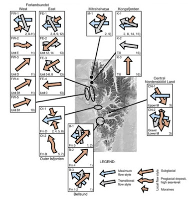
Ice flows from different phases of glaciation in the western part of Svalbard, 
after Landvik et al, 2014.

We can assume that in every glacial cycle, there is an intensification of glacial activity (style 3 >>style 2>>style 1) and that at the end of the cycle, when climate ameliorates, glacial activity reduces (style 1>>style 2>>style 3).  Of course, there may well be oscillations which will mess up this sequence of events, and non-climatic factors can also play a role in determining the course of events. And areas at the core of a glaciated region will experience a complete sequence of events while areas near the ice sheet edge will experience a partial or localised sequence of events which may be unique.

Back to Wales.  A huge amount of work has of course been done over the past century or more, but we are still a long way from understanding how the ice coming from the Welsh Ice Cap interacted with ice from the dominating Irish Sea Glacier.  During the 1900s there were abundant research projects designed to work out the sequence of events as represented in sediment sequences in particular, but in the present century there has been a move to modelling exercises and analyses of "lineations" seen in satellite images -- and for simplicity's sake most of the modelling has ignored the interactions between Welsh ice and Irish Sea ice.  I have done abundant posts on all of this......

Glasser et al (2018) and others have modelled a Late Devensian ice cap with a maximum surface elevation of c 1200m:


However, on this map the white line in places shows the postulated ice cap limit in some places, and the postulated Irish Sea ice limit in others, and ignores abundant evidence of Devensian glacial activity aroun the SW, S and SE peripheries of Wales.

This map, published by the BGS, is more realistic in that it does show the flowlines for Irish Sea ice, but it does not make it clear which glaciation is which, and the implication is that the arrows for the Irish Sea Glacier in the Bristol Channel relate to an earlier glacial episode, and have nothing much to do with the Devensian.  We now know that the glacier limit shown in West Wales is not at all accurate.


So are there many areas in which there were dramatic changes in ice flow directions, as in Svalbard?  In North Wales the situation must at times have been chaotic, with north-flowing Welsh glaciers coming into direct conflict with the south-flowing Irish Sea Glacier.  There must have been similar "glacier collisions" in NE Wales and perhaps in the southern parts of Cardigan Bay.  I have speculated about this with regard to the confusing sediment sequence at New Quay.

In north Pembrokeshire the evidence of striations in coastal exposures of soft sedimentary rocks is difficult to interpret, but there do appear to have been quite wild swings in ice movement directions, and these must have been caused by shifts in the relative dominance of one ice mass or the other.  


The dominant ice movement direction seems to have been from the NNW or NW, and this is confirmed by the maps of erratic transport.


And of course this gets even more interesting when we examine the evidence from South Wales and the Bristol Channel.  This is the modified Kellaway map showing three parallel ice streams in the Bristol Channel.  It has been heavily criticised by some, but it makes good glaciological sense, and if this was to be a map of part of the Svalbard coast, nobody would bat an eyelid.......

Anyway, we need much more work doing on all of this, and I look forward to seeing the models which predict just what went on in the "ice conflict zone', and when.


The West Angle sediment sequence: Morey's paper

Generalised sequence of Pleistocene deposits at West Angle

I thought I should draw attention to the fact that the article by CR Morey on the West Angle sediment sequence has now been placed online by the Ussher Society:

http://ussher.org.uk/journal/90s/1997/documents/Morey_1997.pdf

The main interest of this work lies in the confirmation by Morey that the silt and clay series at West Angle is not a result of a big marine transgression, but is a series of muds and clays laid down in a dune slack situation, probably behind a coastal dune barrier.  The evidence of freshwater organic materials is quite convincing, and most authors are now agreed that the organic sediments (including a peat bed which has been eroded away) probably date from the last interglacial.

https://brian-mountainman.blogspot.com/2017/03/the-west-angle-enigma-2-silt-and-clay.html

However, I part company with Morey when he interprets the overlying reddish diamicton as a periglacial solifluction deposit. This is a weird and unnecessary interpretation of the prominent deposit which occupies the northern part of the cliff exposure:

https://brian-mountainman.blogspot.com/2017/02/the-west-angle-enigma.html


Exposure of the dark red Irish Sea till in the section in West Angle Bay.  The colouration is down to the inclusion of much debris from overridden ORS rocks.

As I wrote in 2017, Morey's illustration of the sequence is so generalised and inaccurate as to be effectively useless.  He does not accept that there is a genuine raised beach deposit near the base of the succession at West Angle, and nor does he accept that his "reddish brown" layer 4(i) is a till layer, in spite of recording within it clasts of ORS marls and sandstones, dolerites and rhyolites. He prefers to follow Bowen (1974) in interpreting this as a periglacial head or slope deposit accumulated under permafrost conditions. He does not explain where all this erratic material might have come from. Nor does he seem to have examined the fresh till that is exposed in the northern coves of West Angle Bay; such an examination might well have convinced him that Late Devensian ice did indeed reach this locality and must have affected the sedimentas at the head of the main bay.

Since 2017 I have made abundant observations on the west and south coasts of Pembrokeshire which have confirmed that almost all of this coastline was affected by overriding ice at the time of the LGM.    Morey's interpretation of the reddish diamicton was no doubt influenced by the widespread assumption (in 1997) that the Late Devensian Irish Sea Glacier dod not extend this far south -- and that therefore everything that looked like a till was probably something else..........  That assumption has now been comprehensively dumped.

This is the crucial part of the West Angle sequence -- a dramatic erosional contact between the interglacial silt and clay series (to the right) and the dark red Late Devensian till (to the left)

So we can suggest that the stratigraphic and age relationships of the West Angle deposits are as follows:

10. Made ground and soil -- modern
9. Dark red stratified horizon -- late glacial (Devensian / Holocene transition
8. Dark red diamicton (non-stratified) -- Late Devensian glaciation (LGM)
7. Orange silt and clay series -- Ipswichian interglacial dune slack environment (freshwater)
6. Grey silt and clay series -- ditto
5. Peat and peaty silt -- ditto
4. Stony grey silts -- up to 1.5 m thick -- ditto (includes some slope breccia material?)
3. Ferruginous bedded sands and gravels -- up to 1.5 m thick -- Ipswichian shoreline deposits?
2. Rounded pebbles / beach shingle in a sandy and gravelly matrix -- up to 1.8 m thick -- Ipswichian raised beach
1. Sand layer -- more than 1 m thick -- Ipswichian sandy beach
Base -- pre-Ipswichian till?  Claimed by some -- not seen by me!

======================================

A RE-EXAMINATION OF THE VALLEY-FILL DEPOSITS AT WEST ANGLE BAY, PEMBROKESHIRE

C.R. MOREY

Morey, C.R. 1997. A re-examination of the valley-fill deposits at West Angle Bay, Pembrokeshire.Proceedings of the Ussher Society, 9, 164-167.

ABSTRACT

The cliffs at West Angle Bay in Pembrokeshire [SM 853 031] display till, apparently of pre-Devensian age, overlain by a sequence of Late Pleistocene deposits. This section has been the subject of conflicting interpretations and has remained enigmatic since it was first described by Cantrill for the British Geological Survey in 1916. A re-examination was prompted by the discovery of new macrofossil material and the fact that, although part of the section has been described as "marine" or "estuarine" in character by various authors, there is no published record of any systematic micropalaeontological work to support such an interpretation.

The picture that has emerged from the current work is that of a valley excavated in bedrock during the Early Pleistocene and subsequently filled by till during a glaciation which transported erratics of igneous material and sediments of Mesozoic and Westphalian age from the north and west. During a subsequent interglacial, drainage was impeded by the build-up of a dune belt at the coast. Alluviation took place in a slack behind the dune belt and it is some of this material that is now exposed in the coast section.

Subsequent cold cycles were marked by gully erosion and by two phases of solifluction. Deposits from the early phase are distinguished by the fact that they contain re-distributed erratic material. There is also evidence for landslipping or subsidence involving partially frozen ground, perhaps following the erosion of a coastal dune belt.

Thursday, 13 August 2020

Bluestone and sarsen at Durrington


The Durrington MOD site "bluestone lithic" -- possibly rhyolite or ash?  The fresh rock is exposed where a geological slice was taken off for lab analysis.  It's certainly not spotted dolerite......

Thanks to Tony for drawing attention to this -- a short report on what was found during investigations at the old MOD HQ at Durrington prior to development as a housing estate.  The site is about 1 km north of the Durrington Walls scheduled monument

https://www.wessexarch.co.uk/our-work/mod-durrington

There is also a longer published report:

Along Prehistoric Lines: Neolithic, Iron Age and Romano-British Activity in the Former MOD Headquarters, Durrington, Wiltshire
By Steve Thompson and Andrew B. Powell
Published by Wessex Archaeology, 2018

Among the probable Neolithic finds, ..........."the most impressive, at least in size where the pieces of worked sarsen stone blocks found in the posthole alignment, the largest weighing in at 15 kg, with two smaller fragments, interpreted as broken flakes, being found alongside it. The use of sarsen as a material to construct stone circles such as Stonehenge and Avebury may suggest this material had some importance to the occupants of Neolithic Durrington, however it is suggested that the stone was discarded after being unable to be worked further. It is also broadly contemporary with the sarsen phase of Stonehenge, however it is possible sarsen was more commonplace than it is today as a number of solitary standing stones are known locally."

Then we find this, also in a Neolithic context;
A piece of worked ‘bluestone’ known as a biface was found in a later ditch close to the intersection of the two posthole alignments. This object is similar to ones found at Stonehenge and is almost certainly of Neolithic date. However, whilst it is likely to have been brought to the site at this time, it could equally be a Romano-British curio or trophy. ‘Bluestone’ is a key material of non-local rocks, many of which were brought from Wales, and most famous for its use at Stonehenge and the ritual activity taking place there.

This is interesting, in spite of the all too typical assumption that the bluestones found in the area must have been "brought from Wales".......

The lump of bluestone doesn't look much like a typical "biface artifact" to me, but there is a great 3D animation on the Wessex Archaeology web site:
This is the description:
The ‘bluestone’ object is a bifacial lithic with polishing and flaking. It was found in a possibly Romano-British feature, next to two Late Neolithic posthole alignments at MOD Durrington. It resembles objects made out of ‘bluestone’, the same as some of the Stonehenge stones. A number of ‘bluestone’ objects have been found across the Stonehenge Landscape, even though not local to the geology.

It is unknown when the object was created, or how it came to be buried at Durrington. Its proximity to the Neolithic posthole alignments could suggest a similar prehistoric date. However, the association with the Romano-British feature could suggest a later curation of the artefact, taken as a memento or trophy.


A section was taken to identify the geology of the rock and shows its original midnight blue colour when it was freshly made. The exterior surface is the result of 4500 years of weathering and wear.


This is all quite intriguing.  No doubt the petrology of the stone will have been sorted out by now.  My best guess is that it is a rhyolite or ash.   The "lithic" is very small, and it does not matter very much whether it is from a Neolithic context or a Romano-British one.  I'll hazard a guess that it is a small erratic pebble that has been bashed about a bit -- but I am unconvinced that the "flaking and polishing" are the results of human interference.  They could be natural features -- and its interesting that the weathered crust (assumed to be the result of just 4500 years of exposure) extends across the whole face of the pebble.  One would have expected the Neolithic (?) flaked areas to show up as a different colour -- with a less well marked crust.   It's difficult to tell what is going on here, even on that wonderful animated 3D image!

Anyway, somebody will probably enlighten us.........

PS.  I knew I wouldn't have to wait for long!  Rob Ixer kindly informs us that it is a piece of foliated rhyolite similar to that found at Rhosyfelin in North Pembrokeshire.  So it can be grouped together with assorted other fragments of the same rock type found  in the Stonehenge landscape.  But this is the first one I've seen that looks like a pebble rather than a fragment knocked off a larger stone.


Wednesday, 12 August 2020

Ice sheet and glacier behaviour in Svalbard


Apparently deranged glacier behaviour on Ellesmere Island, with two big glaciers flowing in the same trough in opposite directions, and with five other smaller glaciers flowing into the trough from flanking tributary valleys.  What is the explanation?


Another glacier collision, this time in East Greenland.  The big glaciers are wasting away, but this is a very complex pattern of conflicting ice flows.

When we see images such as those above, the only explanation of the landforms and glaciers is that the landscape is "inherited" from one or more past episodes in which the big troughs were cut by ice streams that had little or no relationship with the glaciological conditions that currently prevail. 

Anyway, I came across this article a few years ago, and have taken another look at it in the realisation that it also says something about the pattern and history of glaciation in the Celtic Sea arena of the British Isles.  It's a very interesting and enjoyable piece of work.  

Landscape imprints of changing glacial regimes during ice-sheet build-up and decay: a conceptual model from Svalbard
Jon Y. Landvik, Helena Alexanderson, Mona Henriksen, Ólafur Ingólfsson
Quaternary Science Reviews 92 (2014), pp 258-268

https://www.academia.edu/18557412/Landscape_imprints_of_changing_glacial_regimes_during_ice_sheet_build_up_and_decay_a_conceptual_model_from_Svalbard?email_work_card=view-paper

Abstract

The behaviour of ice sheets and their geologic imprints in fjord regions are often multifaceted. Fjords, which were temporarily occupied by fast flowing ice-streams during major glaciations, and inter-fjord areas, which were covered by less active ice, show different signatures of past glaciations. The land and marine records of glaciations over the western Svalbard fjord region have been extensively studied during the last few decades. We have re-examined ice-flow records from stratigraphic and geomorphic settings, and propose a succession of ice-flow events that occurred repeatedly over glacial cycles: the maximum, the transitional, and the local flow style. The differently topographically constrained segments of the ice-sheet switched behaviour as glacial dynamics developed through each glacial cycle. These segments, as well as the different flow styles, are reflected differently in the offshore stratigraphic record. We propose that the glacial geomorphological signatures in the inter ice-stream areas mostly developed under warm-based conditions during a late phase of the glaciations, and that the overall glacial imprints in the landscape are strongly biased towards the youngest events.
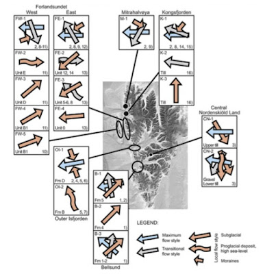

Figure 3 from the article, showing ice flow directions of different ages at the selected sites.  The arrows are overlaid from oldest to youngest.  At first this might look like chaos, or "random" ice flows, but on closer examination you can seed that the oldest ice flows represent a phase (or phases) when the islands were overwhelmed by the ice of the Barents Sea ice sheet, flowing broadly westwards towards its terminus at the shelf edge; and that later phases show the assertion of local topographical controls, with local glaciers becoming increasingly important for the evacuation of glacier ice. 

The authors pull in a vast amount of evidence from submarine and land-based studies (much of it already published) to support the hypoythesis of three different glacial dynamic events for the Late Weichselian glaciation: the maximum glaciation phase, the tributary ice-stream phase, and the local ice caps and readvances phase. They also link these phases to “flow styles” as suggested by Landvik et al. (2013): maximumflow style, transitional flow style and local flow style based, on stratigraphic records as well as geomorphic data. The main criterion for the classification is the degree of topographic constraint on the flow.

1.  Maximum flow style existed when at least parts of the ice sheet experienced topographically unconstrained ice flow during “maximum glaciation” episodes -- of which there have been many. For the most extensive glaciation in the records (the Late Weichselian), the maximum flow style reconstruction is primarily based on seafloor megascale glacial lineations (MSGL) in the fjords and troughs, often associated with terminal moraines on the continental shelf reflecting largely topo- graphically unconstrained ice flow. In the fjords and troughs, the till deposition and MSGL formation suggest that ice-streams existed, whereas the inter-fjord areas experienced a less active ice flow towards the ice-sheet margin.

2.  Transitional flow style is topographically constrained, mainly in a fjord setting. It is found in “tributary ice- streams”, but may also be characteristic of topographically constrained non ice-stream behaviour. Similarly to the maximum flow style, the signatures of transitional flow include seafloor MSGL and drumlins, recessional moraines and grounding zone wedges, and the flow direction is easily identified when it differs distinctly from the preceding maximum flow. For the last glaciation, the transitional flow style is also documented by land records from sites along the fjords: glacial striae, till fabric and provenance of erratic boulders.

3.  Local flow style is also topographically constrained, predominantly in the terrestrial environment -- but here smaller tributary troughs and cirques have a powerful influence.. The most important signatures are terminal moraines and tills deposited by ice flowing from local ice caps, piedmont glaciers, or valley and cirque glaciers. Abundant geological signatures of local flow style from the last deglaciation overprint the older landscape and sediments. In the stratigraphic record, the local flow style is primarily represented by tills containing clasts of local provenance supported by preferred clast orientation and glaciotectonic structures, as well as proglacial meltwater deposits formed during periods of high relative sea level.

Quote:

Fjord/trough (ice-stream) and inter-fjord (inter ice-stream) areas exhibit different glacial landscape imprints, reflecting different flow styles and basal temperature conditions. Ice-streams in the fjords and troughs were probably dominated by thawed bed. The inter-fjord areas seems to have experienced thawed basal conditions only during a late phase of ice-sheet retreat, leaving the distinct glacial signatures of an active zone that migrated over the older landscape.

The composite western Svalbard glacial record shows that these ice-flow styles occurred in a preferred succession during both ice- sheet build-up and decay. Due to the higher preservation potential of the younger geological imprints, developed under warm-based conditions, most studies utilizing geomorphic data for ice-flow reconstructions have tended to be biased towards the latest ice-flow styles, usually the local or transitional flow style.

We suggest the succession of flow styles shown for western Svalbard occurred on a full ice-sheet scale and in particular that the transitional and local flow styles shifted time transgressively to- wards the palaeo centre of the ice sheet as a function of changing ice-sheet thickness and volume. This conceptual model should be valid also for similar palaeo ice-sheet settings in e.g. Greenland, western Norway, eastern Canadian Arctic and Iceland.


There is some interesting modelling in this paper, with the authors examining both the spatial and time dimensions.  They refer to "glacial cycles" and spend some time discussing the landscape inheritance of past glaciations and the powerful "skewing" effect of the LGM or  Late Weichselian glacial episode -- through the complete or partial obliteration of the field evidence (both stratigraphic and landform) from past episodes, some of which might have been more prolonged and more powerful.

 
Map showing the succession of flow styles during the LGM on the west coast of Svalbard.  Note that at the LGM several powerful ice streams occupy the main "glacier discharge routes" and that between these, in the inter-ice-stream areas, there is still enough ice flowing from the barents ice sheet interior to overwhelm the mountains and flow out to the ice edge on the shelf margin. Because the flow is topographically unconstrained, there are no "ice free enclaves" in this piedmont area; ice flowing sluggishly will spread laterally until it is confined or limited by more powerful ice associated with the main discharging ice streams.

The relevance of this for the Celtic Sea arena?  Well, it's not so different.  There was one large ice stream -- the Irish Sea ice stream (ISIS) or glacier, carrying ice from the ice sheet interior.  At some stages there was unconstrained flow across parts of Wales including Lleyn and Pembrokeshire; and at some stages the flow was more like the "transitional flow style" of Landvik and his colleagues, based upon the Welsh Ice Cap operating "autonomously" as an independent accumulation area with radiating ice flow.   The relationships between Irish Sea Ice and Welsh Ice are still being worked out -- and  the Celtic Sea piedmont musty also be worthy of study in its own right.  Again, as pointed out by James Scourse and many other researchers, sea-level rise and fall -- and isostatic adjustments -- will have exerted, at times, a powerful control on the position of the ice edge and the dynamics of the ice masses.

There has been much discussion on this blog about the "shape" and extent of the Celtic Sea ice lobe, as attested by assorted maps as reproduced below.


Glasser et al, 2018, showing what is in my view a highly unlikely eastern edge to the Irish Sea Ice Stream.  The Svalbard research shows that large ice streams in unconstrained situations flow laterally and engulf the lowlands -- meaning that the Bristol Channel is highly unlikely to have remained ice-free. 

An attempt by Prof David Evans to portray a Celtic Sea piedmont dominated by ice flowing from southern Ireland


My own attempt at showing what might have happened with unconstrained ice flow in the Celtic Sea arena during the LGM.  The extent of ice cover must have been even more extensive during earlier glacial episodes........


Wednesday, 5 August 2020

A mysterious Stonehenge bluestone slide


I have been sent some photos relating to British geological sites by a gentleman who recently acquired them.  He wants to remain anonymous, but is happy for the images to be reproduced here.  They seem to have been made by a professional slide maker called AT Davies, but it is a mystery whether he is the same "Davies" who seems to have worked with Teall and Cunnington around 1870 - 1890 in the collecting and examination of igneous fragments from Stonehenge.

The thin section reproduced here, labelled as a diabase from Stonehenge, is at two different magnifications and seen through crossed polars.  It is probably not an "official" slide" in that it has no Geological Survey or Natural History Museum number.

In their paper about HH Thomas in 2018, Richard Bevins and Rob Ixer say as follows:

"In looking at these collections of specimens in more detail, we can see that Thomas examined almost entirely (if not exclusively) debris material from Stonehenge. The Cunnington samples were clearly all debris material. The survey daybook records E1987– 99 as being specimens collected and presented to the Museum of Practical Geology, Jermyn Street, by W. Cunnington, FGS, and adjacent entries suggest that they were donated in 1893 (falling between the entries for 20 March and 5 June 1893). This appears to be a subset of Cunnington’s samples, a more complete set of which were examined and described by Maskelyne (1878), Cunnington (1884) and Teall (1894), and which Harrison et al. (1979) recorded as being collected from excavations at Stonehenge between 1876 and 1881. Curiously, Thomas records some of the Cunnington samples (specifically E1994 and E1993; his pl. XXII, fig. 3 and pl. XXIII, fig. 3, respectively) as being fragments collected by W. Gowland. This is clearly in error, as is his reference to an axiolitic-type rhyolite as being sample E1977 (1923: 251), the latter being a Geological Survey sample collected from the Isle of Man. We think that this should read E1993. Gowland excavated at Stonehenge in 1901, and debris material from Gowland’s excavations was acquired by the Natural History Museum in 1914 (sample numbers BM1914.1–1914.37), so it is probable that Thomas also had access to this as well. Interestingly, however, Thomas makes no reference to these samples."

Maybe it is a different Davies, since the owner of the slide says that AT Davies became a fellow of the RMS in 1916 -- so that would date the slide to that date at the earliest.  But it is possible that this slide will have been seen by HH Thomas while he was working on his Stonehenge bluestones paper which was published in 1923.

Alfred Thomas Davies lived from 1850 to 1934.  The slide is labelled "diabase", and I assume it is unspotted dolerite with an ophitic texture -- but I stand to be corrected.  (When I studied optical mineralogy I hated it with a passion, and absorbed virtually no information!  Ixer and Bevins would be appalled at my lack of judgment....!!)  But that was a very long time ago.


Here is a picture of the little cabinet of slides -- the labelling is somewhat erratic, but there is some interesting material in there!