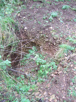
Close-up of the terrace gravels exposed on the flank of an animal burrow (thanks to Alex for this)
I have received some very interesting info from Alex, who has been over to take a look at the famous patch of gravels on the southern flank of Bleadon Hill (ST349573) not far from Weston Super Mare. The altitude here is about 82m.
In the past, this has been described as a "moraine ridge", but it is clearly not a moraine since there is no evidence -- in the few published studies -- of any directly deposited glacial materials. It has been described by Findlay and his colleagues (in 1972) as a ridge, but from the description and photos provided by Alex it looks more like a terrace. What one cannot say without further work is whether it is a constructional terrace composed of a thick sediment sequence, or a thin veneer resting on an erosional bench.
It's not easy to pick up the topography from this photo (thanks, Alex!), but it looks as if the two houses are resting on the gravel terrace......
The photos taken by Alex of the materials currently exposed (around badger setts etc) show pebbly gravels at least 2m thick which comprise pebbles mostly under 2 cm across, with some up to 8 cm across, without much of a matrix. They have been described as "openwork gravels". Other observers suggest that the gravels are dipping towards the NE -- more or less parallel with the contours and suggesting current flow around the flank of the hill, broadly from west towards east.
Most of the clasts are sub-rounded, suggestive of water abrasion -- and to me they look like classic glaciofluvial materials. There is some cementation, on the points of contact between clasts -- but the solid cementation that we see in raised beach deposits (for example) is absent. Most of the pebbles are made of Carboniferous Limestone, but Alex says there are many erratics as well. They must have come from the west. Findlay and his colleagues suggested that there were partly cemented sands and silts beneath the gravels, but they were not able to see a clear contact between these gravelly beds (above) and sandy beds (below). Intriguingly, they said that the lowest sandy beds were unconsolidated, with beds dipping southwards at c 37 degrees.
I think we can dispense of some of the wilder explanations of these gravels and accept that they are of glaciofluvial origin. I can see no possibilities of them being pre-Quaternary deposits here, and I see no merit in trying to explain the gravels away as old beach deposits or as the high remnant of old river terraces. So they must indicate the presence of glacier ice from the west with a surface at least as high as 82m. There are two possible explanations. The gravel terrace might be a kame terrace against a hillside, emplaced by meltwater flowing along an ice edge towards the NE. The other possibility is that the gravels represent the shoreline of a glacially-impounded lake with its surface altitude at 82m. I don't like this explanation so much, since we still have to find a source for the pebbles, and without the presence of a nearby ice edge, where might they have come from? Also, if there was a prolonged water-level stillstand here, where are all of the other shoreline traces elsewhere on the hillside?
So -- there was ice present on the flank of Bleadon Hill. A kame terrace was formed between the ice edge and the hillside. When? The assumption has to be that the glaciation was the Anglian -- and this might be confirmed by the partly-cemented nature of the deposits. But we can't rule out a Late Devensian ice incursion from the west -- and in the light of the accumulating evidence from many other sites about the extent of the Irish Sea Glacier, around 20,000 years ago, I think we should keep the dating options open..........


2 comments:
I expect PeteG will be keen to read this Post, as he's made comments on various Posts to do with the North Somerset coastal areas such as Portishead and Clevedon areas in the past. At present, there is a problem with 02 and its mobile network today, still not solved......
I'm still puzzled by the situation around Bath -- apparently very old glacial deposits, with remnants just left in fissures etc. But how do those deposits relate to the landscape features of Mendip? Looking forward to seeing more from Alex on this......
Post a Comment