How much do we know about Stonehenge? Less than we think. And what has Stonehenge got to do with the Ice Age? More than we might think. This blog is mostly devoted to the problems of where the Stonehenge bluestones came from, and how they got from their source areas to the monument. Now and then I will muse on related Stonehenge topics which have an Ice Age dimension...
THE BOOK
Some of the ideas discussed in this blog are published in my new book called "The Stonehenge Bluestones" -- available by post and through good bookshops everywhere. Bad bookshops might not have it....
To order, click HERE
Some of the ideas discussed in this blog are published in my new book called "The Stonehenge Bluestones" -- available by post and through good bookshops everywhere. Bad bookshops might not have it....
To order, click HERE
Saturday, 30 September 2017
Cot Llwyd henge?
Well, blow me down! Bing Maps has recently put up some new imagery of North Pembs, showing a winter landscape with a low sun.
In the centre of this image is the Cot Llwyd "roundhouse" -- with a diameter of about 10m. It's on the edge of the common, on the northern slope of Carningli. Generally this is assumed to be one of the better preserved of the Bronze age dwelling sites in this area. Grid ref: SN056380.
I have never seen this before, on other satellite images, but suddenly we can see that there is a much bigger circular structure, with the roundhouse in the middle. I estimate that the diameter of the big circle is about 70m. The shape is that of a reversed capital D -- very strange. Maybe the planned circular feature was not completed, and was finished off later with a straight wall on its eastern flank? Was it a henge? There does not seem to be an associated ditch either outside or inside the wall or embankment.
There is another mysterious uncompleted feature near Carn Llwyd, maybe 500m to the east. There is a curving section of ditch and embankment about 50m long. That looks as if it might have started off as an ambitious project for a circular feature with a diameter of at least 200m. That's truly enormous. The bank section is in the centre of this image:
Friday, 29 September 2017
Where was the Anglian ice sheet edge?
This is a topic to which we have returned many times, and will no doubt return again.......
I have been taking a fresh look at the highly influential paper by Patton et al (2016) which applies a more sophistcated modelling technique than ever before to the Eurasian ice sheet complex -- including the Celtic Ice Sheet (otherwise called the British / Irish Ice Sheet or BIIS). Although the work relates to the climatic and other conditions for the Late Weichselian (let's say 40,000 BP to 15,000 BP as being relevant to SW Britain) the modelling is in some respects more applicable to the earlier glaciations, since ground truthing suggests that the Celtic Ice Sheet never did develop to the full extent as predicted by the model.
The map above shows the most commonly assumed Devensian ice limit (red line) for the British Isles, which is clearly inadequate in many respects. The area defined by the wavy dark blue line shows the maximum extent of the modelled ice sheet, based on an analysis of a vast range of different parameters. The orange areas are the areas of assumed highest erosion -- the dark blue area shows the ice shed location, stretching from the Lake District across to the Isle of Man and thence towards SW Ireland. Note that the ice is shown impinging well into the counties of Devon, Cornwall and Somerset, onto Salisbury Plain, and across the Midlands towards The Wash, incorporating a large area to the north of the Thames Basin assumed to have been unglaciated in the Devensian.
Take a look at these maps as well:
The upper map shows the positions of the ice divide around 27,000 BP (red), according to the run of the model, and around 22,000 BP (black). An ice divide running across Ireland from NE to SW must have forced ice flow on one flank towards the SE and on the other flank towards the NW. As far as St George's Channel and the Celtic Sea are concerned, this supports my thesis of a Celtic Sea ice mass made up of ice from the Irish Sea Glacier, but with a powerful mass of ice coming from central Ireland, and forcing the ice to flow eastwards, as shown on this map:
The similarity between these maps is remarkable, given that my map is based largely on ground evidence, and theirs is based on computer-based glacier modelling.
So far so good -- but the intriguing thing is that my map shows my assumed Anglian glacial scenario, and theirs shows a theoretical Late Weichselian scenario! I need advice from the experts. Watch this space........
-----------------------
Henry Patton, Alun Hubbard, Karin Andreassen, Monica Winsborrow, Arjen P. Stroeven. 2016.
The build-up, configuration, and dynamical sensitivity of the Eurasian ice-sheet complex to Late Weichselian climatic and oceanic forcing. Quaternary Science Reviews, Volume 153, 1 December 2016, Pages 97–121
http://dx.doi.org/10.1016/j.quascirev.2016.10.009
http://www.sciencedirect.com/science/article/pii/S0277379116304498
Note: Late Weichselian = Late Devensian
-----------------
Abstract
The
Eurasian ice-sheet complex (EISC) was the third largest ice mass during
the Last Glacial Maximum (LGM), after the Antarctic and North American
ice sheets. Despite its global significance, a comprehensive account of
its evolution from independent nucleation centres to its maximum extent
is conspicuously lacking. Here, a first-order, thermomechanical model,
robustly constrained by empirical evidence, is used to investigate the
dynamics of the EISC throughout its build-up to its maximum
configuration. The ice flow model is coupled to a reference climate and
applied at 10 km spatial resolution across a domain that includes the
three main spreading centres of the Celtic, Fennoscandian and Barents
Sea ice sheets. The model is forced with the NGRIP palaeo-isotope curve
from 37 ka BP onwards and model skill is assessed against collated
flowsets, marginal moraines, exposure ages and relative sea-level
history. The evolution of the EISC to its LGM configuration was complex
and asynchronous; the western, maritime margins of the Fennoscandian and
Celtic ice sheets responded rapidly and advanced across their
continental shelves by 29 ka BP, yet the maximum aerial extent
(5.48 × 10⁶ km2) and volume (7.18 × 10⁶ km3)
of the ice complex was attained some 6 ka later at c. 22.7 ka BP. This
maximum stand was short-lived as the North Sea and Atlantic margins were
already in retreat whilst eastern margins were still advancing up until
c. 20 ka BP. High rates of basal erosion are modelled beneath ice
streams and outlet glaciers draining the Celtic and Fennoscandian ice
sheets with extensive preservation elsewhere due to frozen subglacial
conditions, including much of the Barents and Kara seas. Here, and
elsewhere across the Norwegian shelf and North Sea, high pressure
subglacial conditions would have promoted localised gas hydrate
formation.
Thursday, 28 September 2017
The Late Devensian Glaciation in Wales and SW England
Late Devensian Glaciation of South-western Britain and the Celtic Sea
Here is my latest attempt to summarise what is currently known about the extent of ice in the Late Devensian, around 25,000 years ago (see Note). The maximum ice positions may have occurred at different times in different parts of the glaciated area, as a result of surges or pulsing behaviour. Also, the boundary between Irish Sea ice and ice from the Welsh and Irish Ice Caps must have oscillated in a fashion not currently fully established.
Note the following:
1. The ice movement directions shown for the Celtic Sea Piedmont Glacier are approx 90 degrees away from the directions assumed by most glacial geomorphologists in their maps. This is because ice marginal deposits at more or less the same levels (ie just a few metres above present sea level) in western Pembrokeshire, on Caldey Island and in the Isles of Scilly cannot be explained by a glacier with a gradient running from NE towards SW. Ice must always move perpendicular to the ice edge except in troughs and other tightly constrained situations. That means the ice gradient must have run from NW towards SE, as shown on the map, driven from a dynamic and vary large ice dome over Ireland.
2. If, as I believe, glacier ice over-rode Lundy Island and impinged against the coastline of Devon and Cornwall, there is a possibility of a large meltwater lake being trapped within the Bristol Channel.
3. I have shown local ice caps over the uplands of Devon and Cornwall, and assume that in the Late Devensian they did not come into contact with ice coming in from the NE.
Note added 29.9.2017: recent papers are suggesting that the glacial maximum occurred around 25,000 years ago -- this pushes the date back by about 5,000 as compared with the widespread assumptions of a few years ago. Partly this adjustment is related to the advent of new dating techniques, which have supplemented -- and sometimes -- supplanted evidence based solely on radiocarbon dates on organivc materials.
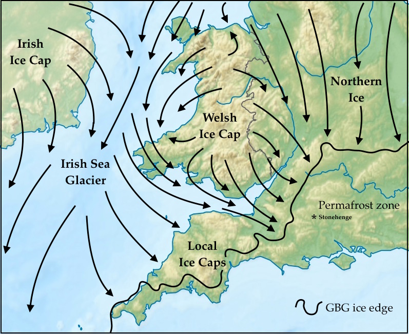
The Greatest British Glaciation in Wales and SW England
The extent of the "Greatest British Glaciation" in the south-western quadrant of the Celtic Ice Sheet (sometimes called the British and Irish Ice Sheet)
This is my latest attempt to map the greatest-ever Pleistocene extent of ice in this area, bearing in mind evidence from a wide variety of sources. I'll be happy to discuss modifications if anybody has any doubts about what the evidence on the ground actually shows.
When was this? The jury is still out. The most common assumption nowadays is that the glaciation was very ancient indeed -- the Anglian Glaciation (MIS 12) conventionally dated to c 450,000 years ago. However, Phil Gibbard is suggesting nowadays that maybe this was the Wolstonian, which used to be called the Riss or Saalian glaciation on the continent, and which occurred around 200,000 years ago (MIS 6). Maybe the ice edge shown is a composite one, but this will need to be established by cosmogenic dating such as that undertaken by the BRITICE project over the past few years.
Please note the following:
1. The ice direction arrows shown are approximate only -- one must bear in mind that there are considerable swings as ice masses wax and wane. For example, before the Irish Sea Glacier became prominent, the Welsh Ice Cap would have been more extensive, pushing ice further out from the core of the Welsh uplands. Individual outlet glaciers at such a time would also have been more topographically controlled. Something similar might well have happened at the end of the glaciation, as the Irish Sea Glacier waned and retreated from its maximim position. We do not know at present how many phases or pulses of glacier expansion there may have been -- the evidence on the ground is very patchy.
2. South-central England is shown as a permafrost zone, but there must have bee extensive areas of perennial or semi-permanent snowfields.
3. It is assumed that the ice extended to the south of the Isles of Scilly and that there may well have been a large calving bay at the ice grounding position, in the Celtiv=c Sea and off the bottom left corner of the map.
4. I'm assuming that moving ice pressed onto the Cotswolds, into the Bristol and Bath area, over the Mendips, and across most of the Somerset Levels. I believe that there us reasonable evidence to support the position of the ice limit as shown.
5. In Devon and Cornwall, it is reasonable to assume that there were small discrete ice caps over Exmoor, Dartmoor, Bodmin Moor and some of the other uplands. These ice caps might have coalesced, and they would have been in contact with the Irish sea ice somewhere near the position of the present coastline.
6. Note that the coastline is shown here for guidance only. In reality, at the time of this very large glaciation, sea-level must have been at least 120m lower than it is today.
After that fruitless quarry hunt, normal service is resumed........
Over the last week or two I have spoken to many people -- including archaeologists -- about the recent archaeological work on the northern flank of Preseli, and I am intrigued by the fact that NOBODY has even mentioned bluestones or quarries. There now appears to be widespread scepticism about the existence of the Neolithic quarries so beloved by MPP and his friends, and an acceptance that the evidence they have unearthed during their mad quarry hunt has been so equivocal and unconvincing that the whole idea is best dropped. For example, the radiocarbon dates and organic remains from Carn Goedog and Rhosyfelin do nothing at all to support the idea of bluestone monolith quarrying, but simply demonstrate the intermittent occupation of hunting and gathering sites.
In contrast, a number of people have said to me that the archaeologists are getting back to the normal practice of their trade by subjecting a smallish area to intense scrutiny (using geophysics, aerial surveys and LIDAR) and finding some rather interesting cultural features from the Neolithic, Bronze Age, Iron Age and Roman times. This shows a long history of settlement in an area with quite positive environmental attributes. Essentially this is a random process -- and a number of experienced archaeologists have said that MPP and his team could probably have subjected almost any part of North Pembrokeshire to a similar level of technical scrutiny and manpower investment, and would have obtained quite similar results. We knew already from the excellent work done by Dyfed Archaeological Trust and other university groups over the years, that there are widespread cultural traces across the landscape and that a large proportion of them have survived because the level of agricultural and other development here has been lower than it has been across much of south Pembrokeshire.
Many of the relevant records are in the Coflein and Archwilio databases, and some are contained in this Report:
www.dyfedarchaeology.org.uk/projects/schedulepembroke2011.pdf
It's a bit out of date now, but is very valuable nonetheless.
So the feeling seems to be that the digs at Pensarn (three excavations), Parc y Gaer (one excavation) and Waun Mawn (six pits opened) represent a welcome return to normal service -- involving a lot of students, who will have obtained valuable training in how a good dig should be run.
No additional significance can be attached to these digs. There is nothing "special" about the areas investigated, and I hope that the archaeologists will resist the temptation to pretend that there is. A location does not become special or significant just because MPP and his colleagues have dug there. And as I have noted before, and as many others have noticed, there is nothing in any of these recent digs that has anything to do with bluestones, quarries, Stonehenge, Carn Goedog, Rhosyfelin, or Stonehenge. It would be quite preposterous for MPP and his team to pretend otherwise.
So a gentle request to the teams who have been at work on these sites in 2017 -- please add your records to the database of prehistoric sites for North Pembrokeshire, and follow the unassuming and efficient practices of the Dyfed Archaeological Trust. Write and publish your peer-reviewed papers if you will. Please resist the temptation to speculate and to tell elaborate stories. Place your dig diaries and excavation records into the public domain as quickly as you can, and spare us any additional hype.......
Wednesday, 27 September 2017
The geologists who stepped on the hornet's nest
On this blog we know and love geologists Richard Bevins and Rob Ixer, since they feature in a vast number of posts and have made amazing contributions to our understanding of the geology of the bluestones. And Rob personally has been prepared to get involved in good knockabout debates on a wide range of issues, and to explore the pros and cons of many theories of geological, geomorphological and archaeological interest. In the comments sections following a myriad of posts, he is a prominent and learned contributor. For that, he deserves enormous respect.
But one thing has been puzzling me greatly for the past seven years or to -- why is it that two reputable geologists have turned into evangelists for the Neolithic quarrying thesis so enthusiastically advocated by Mike Parker Pearson and his team? They claim, whenever you ask them, that they are entirely neutral in their utterances, and that they maintain a certain academic detachment from the grubby business of archaeological disputes, but the evidence is rather strong that they are fully signed up to the quarrying idea -- and indeed we have speculated on previous posts that as long ago as 2011 they actually pushed our friend MPP into some of his more effusive and picturesque statements about Pompeii, smoking guns and proto-orthostats. Consider the following statements made by Drs Ixer and Bevins, from their recent published output:
"There is clearly still much to learn here, but as work on the Preseli quarries continues, we hope that our detailed petrology will help to resolve the ongoing debate about how the bluestones arrived at Stonehenge and from exactly where."
"So the contents of a 60-year-old box led to the discovery of the first secure Stonehenge-related quarry site, confirming that man moved the bluestones.”
“.......very recent excavations at Carn Goedog have revealed evidence for Neolithic working of the outcrop.”
“........ archaeological excavations have shown features consistent with ancient quarrying.”
“The best that can be hoped for is that a number of undisputed Neolithic quarry sites can be found.”
"It's like an IKEA. You just walk up to it, take what you want and take it away."
“The discovery of a megalithic bluestone quarry at Craig Rhos-y-felin in 2011 marked a turning point in this research. Subsequent excavations have provided details of the quarrying process......”
“Colluvium has buried and protected the remains of prehistoric quarrying from subsequent stone removal and disturbance in the medieval and modern era.”
“Six megalith-quarrying features have been discovered at Craig Rhos-y-felin.”
“There is relatively little debris within the quarry to indicate the methods used for detaching monoliths from the rock face.”
“It is possible that the bluestone monoliths were taken directly from their quarries to Salisbury Plain.”
I know that all of these statements are taken out of context, but they do not contain many signs of neutrality or impartiality, as I think readers might agree. But how can it be that two senior earth scientists are apparently prepared to ignore the evidence of earth surface processes that various people have presented for Rhosyfelin, Carn Goedog and many other Pembrokeshire sites, and have decided instead that assorted natural features and sediments are not natural, but are man-made?
One reason might be that many of their papers are published in archaeological journals, and that they have been seduced away from pure geology into saying things that the archaeologists (or maybe just some of them) would quite like to hear? There have been some strong personalities in the ranks of senior archaeologists who have been arguing for Neolithic quarries for many years now -- think of Darvill, Wainwright, Parker Pearson, Pollard, Richards, Welham, Pitts etc. Their research agendas and projects, and their hypotheses, pull in other people -- and when joint peer-reviewed papers or popular magazine articles appear with multiple authorships, the principle of corporate responsibility applies. For example, the big 2015 Antiquity paper on Rhosyfelin (which I still think of as one of the worst I have ever read) had no less than 14 authors, and whatever nonsense there is within that paper now has to be defended by all of them. Nobody can break ranks and say "Well, actually, I never did agree with what was said on page fifteen......" I still think that Rob Ixer and Richard Bevins made a grave mistake by ever agreeing to contribute to jointly authored papers like this one -- the millstone that hangs around Mike Parker Pearson's neck hangs round their necks as well.
Another reason why the geologists have been signed up as supporters of this Neolithic quarrying business is, I believe, that they have just not been able to do adequate fieldwork in the area that they are writing about. Richard Bevins knows the area well, having wandered about all over the outcrops of Fishguard Volcanics over many years, and having collected hundreds of geological samples from useful exposures. But how much time has he spent in the company of glaciologists or geomorphologists on these field visits? I just don't know, but I'll hazard a guess that the answer is "Not very much." He is Keeper of Geology at the National Museum of Wales in Cardiff, with vast responsibilities, so it's a miracle that he is able to do any fieldwork at all, and to maintain an incredible flow of research publications. I am lost in admiration for his dedication and his commitment to research. As for Rob, he lives a very long way away from Pembrokeshire, and is involved in such detailed lab-based petrography, and across such a wide range of topics, that it would be not far short of another miracle if he has ever managed to find the time to wander across north Pembs and simply look at the landscape and the processes that have fashioned it.
And thirdly, I think the geologists have gone with quarrying because they (like everybody else) are attracted by the spectacular, which is always more interesting than the mundane. Although they are earth scientists, they probably quite like the idea of our heroic ancestors doing wondrous things. And from an academic standpoint, they probably quite like the idea of fame and notoriety. You just have to look at the string of press releases to which their names are attached -- in those, caution is thrown to the winds, and IMPACT is everything. They can't blame university or museum press officers for the purple prose -- they are the ones ultimately responsible. And hey -- they might even appear in National Geographic documentary one day. And how exciting is that?
Finally, I have become convinced that the geologists have gone along with the quarrying idea -- and have ended up promoting it -- because they think that the evidence for glacial bluestone transport is in some way deficient. They have, I assume, taken on board the idea that "glacial transport was impossible" because, at some stage, James Scourse and Chris Green said so. So by default they have to accept that human transport WAS possible, and that the quarrying of the bluestones was possible too. As I have said many times before, that is not very scientific, because it conflates various issues. There are three issues under debate -- stone entrainment, stone transport, and stone dumping. If we are trying to be good scientists, we need to examine the evidence for each one of these issues independently, without allowing assumptions about the other two to influence our interpretation of the evidence on the ground. What the geologists have done, I fear, is to assume that there are quarries at Carn Goedog and Rhosyfelin because there are not enough bluestones scattered about on Salisbury Plain. Hmm --- how logical is that?
I write this post not in anger but in sadness -- since I have enormous respect for the two geologists involved, and the great work they have done. So if I was to write a press release about all of this I would put on top of it the title: "The sad case of two good geologists led astray".
------------------------
Monday, 25 September 2017
New work at Waun Mawn
It's rather interesting that work has resumed at Waun Mawn at grid ref SN083341. Apparently work started there very late in the digging season, maybe because the archaeologists were frustrated at having found no trace of proto-Stonehenge at either Pensarn or Parc y Gaer! Anyway, there are signs of great activity up there, and some seriously heavy plant has been used. It's all a bit of a mess at the moment, but it will no doubt settle down again over the winter..........
I'm quite pleased to see that this new work is going on, because the Waun Mawn - Tafarn y Bwlch - Cnwc yr Hydd area is extremely interesting. Hummocky morainic topography, standing stones, old stone walls, ancient trackways, and even traces of an old deer park......... Use the search box to find previous posts. If there is a Neolithic quarry anywhere in this part of North Pembs, it is here, at the top of the hill -- but there are other pock-marks lower down as well, from which rhyolite and metamorphosed shales appear to have been taken. Goodness knows why. (Maybe the quarries are quite modern, having been used for road material for the trackway up to Gernos Fach?)
On the platform halfway up the hill there are 4 big stones that appear to have been used in a stone setting. They are all dolerites picked up in the vicinity, all very heavily abraded and weathered. They are certainly not freshly quarried from anywhere -- they are classic glacial erratics, although they have probably not travelled far from their places of origin. (But who knows? They could have come from Cilgwyn or Carningli.) Only one of the stones is standing, and there are two very big recumbent stones and one smaller recumbent stone which is just visible above the turf. One can't see the full dimensions of the stones, but I reckon the two big ones each weigh between 6 and 8 tonnes.
The archaeologists have opened up six pits and closed them again. These are the locations:
Two of the pits have been dug adjacent to recumbent stones, and four very extensive exploratory pits have been opened up -- two to the west and two to the east of the visible stones. The stones may have been placed in the ground about 10m apart. Rumour has it that two sockets have been found -- I'm not sure whether these relate to stones that are still there and have fallen over, or to stones that have gone missing........ I hope the archaeologists will publish a field report soon and give us the info on that.
Recumbent stone number one -- the westernmost stone in the series. You can see the traces of the dig around the stone, and at top left you can see the position of one of the exploratory digs.
Recumbent stone number two -- there has been no dig adjacent to this stone
Recumbent stone number three -- apparently the smallest of the three. There has been excavation on all sides of this stone
I'm a bit more convinced than I was that the stones may lie on the circumference of a very large circle. If so, it must have had a diameter of around 140 m -- that is enormous, and much larger than the footprint of Stonehenge. On the other hand, Avebury outer circle has a diameter of 331m, and Stanton Drew is 113m in diameter -- so who knows what might have happened here?
I still think that on balance this is a rather wonky stone alignment. My reason for thinking that is that a circle with a diameter of 140 m would not have fitted onto this little step on the hillside-- it would have spilled over onto the steeper slope below, so that parts of the circle would have been quite invisible from other parts. That would not have made any sense at all..........
Anyway, all very interesting, and we look forward to hearing what the archaeologists have to say about this site in due course.
Subscribe to:
Posts (Atom)