THE BOOK
Some of the ideas discussed in this blog are published in my new book called "The Stonehenge Bluestones" -- available by post and through good bookshops everywhere. Bad bookshops might not have it....
To order, click
HERE

Thursday, 3 March 2011

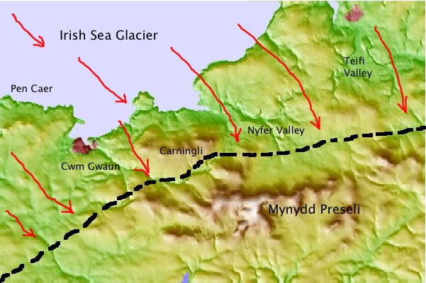
North Pembrokeshire Devensian ice limit

This is my current "best guess" regarding the location of the Devensian ice limit across North Pembrokeshire.  This is a big change in my thinking since those far-off days when I was a research student and university lecturer.  It's not that far removed from the position of the South Wales End Moraine described by Charlesworth in 1929, and from the line published many times since 1973 by Prof David Bowen.  Most geomorphologists nowadays seem to think that the line is somewhere near that shown on the map.  Key features:

1.  The line incorporates all of the Lake Teifi, Lake Nevern and other lake deposits now attributed to the impounding of river and snowmelt waters in the big north-flowing river valleys during the ADVANCE phase of the Irish Sea ice sheet across the position of the N Pembs coast.

2.  The line incorporates the "ice moulded tors" of the Fishguard - Dinas area and those of Pen Caer, but the fragile crags of Maiden Castle and Lion Rock, near Treffgarne, are outside the line.

3.  The extensive fluvio-glacial deposits of the Newport - Moylgrove - St Dogmaels upland are explained as features associated with catastrophic ice wastage at the end of the glacial phase.  So are the other meltwater deposits of the Gwaun Valley area, and Mathry Road near Letterston.

4. I'm assuming that the whole of the St David's Peninsula (Dewisland) was covered by glacier ice at this time.  This is consistent with the distribution of tills around the coasts of the peninsula.

5.  Cwm Gwaun and the other channels of the Gwaun - Jordanston channel system are all relics of earlier glacial phases, but they were used again by marginal and sub-marginal meltwaters during the Devensian.  I think that the ice edge ran approximately along the route of the Gwaun Valley.

6.  The Carningli-Dinas upland ridge was overridden by ice coming in from the NW.  Maybe the highest point on Carningli remained above the ice as a small nunatak.

7.  One big problem remains to be resolved.  Did the ice override the Carnedd Meibion Owen ridge, on the south side of the Cilgwyn depression, and did it press up against the northern flank of Mynydd Preseli?  Etienne et al seem to think that the ice did not press that far south, and that there was a vast glacial lake impounded against the north flank of the mountain.  I would like to see some deposits or shorelines that might prove that -- and I am inclined to the view that the tors of Carnedd Meibion Owen WERE overridden at this time, and that ice may have reached Carn Alw and even spilled over the ridge into the Cern Meini area.  There are remarkably fresh glaciated pavements and slabs at both locations......

8.  I'm increasingly convinced that this was a very short-lived advance, with the ice at its maximum position for maybe no more than a few decades.  My reason for believing that is that there are no massive end-moraines in the region, and not even any obvious shorelines such as we would expect if lakes had persisted for centuries in key "impounding" locations.

More work to be done -- but I think we are getting there.....

Stonehenge Unhinged

 ... and here is Stonehenge Unhinged, which has now been on YouTube for some time, upsetting a few people in the process!


Talk at the Do Lectures

In case any blog followers have not seen my Do Lecture on the subject of Stonehenge and the Bluestones, here it is...... https://thedolectures.com/talks/dispelling-the-stonehenge-myth/

Wednesday, 2 March 2011

Carn Meini -- the manufacturing of a magic mountain


I have lost count of the number of times on which I have come across references to the "magic" or "sacred" mountain of Carn Meini (Carn Menyn) at the eastern end of Mynydd Preseli.  Authorities including Herbert Thomas, Richard Atkinson, Geoffrey Wainwright and Tim Darvill have simply assumed that its sanctity in ancient times is beyond question, and that this is what underpinned the decision by Neolithic tribesmen to quarry the spotted dolerite monoliths from these craggy tors and to drag them all the way to Stonehenge.  One of the theses is that the spotted dolerite reminded them of the night sky, full of glittering stars.  Another is that the rock outcrops were prominent on a jagged upland ridge close to a trading route, looking like a cock's comb against the evening sky.  Some writers have speculated that the crags of Carn Meini were the first features seen from the sea by incoming sailors crossing over from SE Ireland -- and that this too helped to invest Preseli with an aura of sanctity.  Profs W and T have of course insisted that since Neolithic times there has been a tradition that the spotted dolerites have healing qualities, and that the "sacred springs" of the area are proof of the thesis.

The roots of this tradition that Carn Meini may be magical or sacred probably go back no further than Rev Done Bushell, Prof WF Grimes and Sir Cyril Fox -- but even they were more concerned to promote the idea of eastern Preseli being in some way "a prehistoric Holy Land",  rather than homing in on Carn Meini itself.

Time for a reality check.  In Neolithic and Bronze Age times the tors of Carn Meini may well have been less prominent than they are today, since they would have been surrounded by scrub woodland.  Carningli, Frenni Fawr and Foeldrygarn are far more prominent as landmarks.  Bronze Age sites are no more frequent around Carn Meini than they are anywhere else in upland Pembrokeshire, and examinations of cromlechs and standing stones by Stephen Briggs and other archaeologists show that spotted dolerite was NOT used preferentially to other more local rock types.  People simply used whatever was to hand when they had it in mind to build a tomb or erect a setting of standing stones. 

There is no evidence in local folklore that the Carn Meini area was ever revered in any way.   One of the best guides to "ancient thinking" is the collection of tales known collectively as "The Mabinogion".  Some of the tales go back to the Iron Age, and so far as I am aware (somebody will correct me if I am wrong) Carn Meini is not mentioned at all.  Dyfed is mentioned as a place of mystery and enchantment.  But the big "sacred places" in West Wales that DO feature in the stories are Narberth, Abercuch and Grassholm -- each with connections with the Otherworld.  Preseli is mentioned, in connection with the battle between King Arthur and his knights and the Great Black Boar -- but the key location there is Cerrig Marchogion, not Carn Meini.

Have Darvill and Wainwright demonstrated beyond doubt that Preseli spotted dolerite was valued for its healing properties?  Not at all.  I agree with Robin Heath that the supposed “healing properties” of the stone have simply been invented.  In more than 30 years of collecting local folk tales and walking in the Preseli Hills, I have never come across a single reference to any healing properties attributed to spotted dolerite.  In a 1991 survey of 25 megalithic structures (cromlechs, standing stones and stone settings) in the environs of Preseli, Thorpe and others found that only four contained spotted dolerite, and that even in those four it was not exclusively used.  The idea that spotted dolerite was used preferentially for healing purposes or for anything else is sheer fantasy.

Doesn't the evidence of a “Preselite” axe factory in Preseli suggest that spotted dolerite was highly valued?  As we have seen, there is no evidence of a centre of axe head production in the Preseli Hills, in spite of the fact that archaeologists have been hunting fruitlessly for it over several decades.  Neither is there anything to suggest that “preselite” axes were specially valued in preference to other axes made of distinctive stone types.  It is a mistake to refer to these axes as a single group, since they come from many different igneous rock sources.  If there was an axe factory anywhere which specialised in the use of spotted dolerite, it was probably at or near Stonehenge, where raw materials were abundant, either from rejected or broken bluestone monoliths or from smaller spotted dolerite erratics which were too small to be set in the ground. It's interesting that Profs D and W -- in their most recent article -- seem to be quite attracted by this idea.

Doesn't the frequency of healing springs in the Carn Meini area point to the area having a magical or sacred reputation?   The hypothesis of the “Neolithic Lourdes” proposed by Darvill and Wainwright has no basis to it.  Whatever went on at Stonehenge, bluestones are not used preferentially in the structures built over springs and wells in the Carn Meini area.  Springs  (sacred or profane) are no more frequent in the Carn Meini area than in any other part of the Preseli uplands, and having studied this area since my student days I can say with hand on heart that I have never come across any “folk reference” to any healing power acquired by flowing water that has come from a bluestone source.  The one spring which is cited by Darvill and Wainwright  (Ffynnon Beswch or “cough spring”) is not in an area of spotted dolerite at all, but rises in an area of rough ignimbrites.  That spring, like thousands of others throughout the UK, may have had a medieval or later tradition of healing associated with it, but there is absolutely no reason why it should be linked in any way to Stonehenge.

I'm sorry if this sounds terribly unsporting and equally unromantic, but I am forced to conclude that the idea of Carn Meini being magical or sacred has been entirely manufactured within the last century, by a group of archaeologists determined - for a variety of reasons -- to promote the HHT human transport theory.

 ----------------------------------------
See also this post: Wednesday, 15 December 2010 "Preseli -- A Stone Age Holy Land?"
http://brian-mountainman.blogspot.com/2010/12/preseli-stone-age-holy-land.html
The storm clouds gather


Fabulous photo.  I'm pasting it here for no other reason than that it's fantastic!!  Taken by a reader called photomarc, and published in the Los Angeles Times.

Tuesday, 1 March 2011

Open to interpretation....


Top:  hammerstone, found today while wandering on the common, at c 270m on the south flank of Carningli.  it is made of dolerite, and is about the size of a man's fist.

Bottom:  cupmarks on a dolerite surface, c 260m asl on the south flank of Carningli.

Nah -- only joking!  The top picture shows a typical sub-rounded cobble found in a thin veneer of till on the south side of the mountain.  The one below shows a typical scalloped surface on a glaciated slab of dolerite bedrock.  The "cupmarks", hollows and pits are almost certainly weathering phemomena, possibly created under a peaty layer where acidic moisture collects in hollows and enhances the breakdown of the rock matrix and the release of mineral crystals.

It just goes to show that you need a geologist or a geomorphologist with you at all times!!

More on HH Thomas

 I have always been intrigued at the manner in which one man, Herbert Henry Thomas, managed single-handedly to change the world-view of what Stonehenge is and how it was made -- with his  famous 1921 lecture and his even more famous 1923 paper in the Antiquaries Journal.  He is mentioned in many of my blog entries (to find them you can use the search facility).  I discovered this Wikipedia entry on him -- and although I had read a lot about him before, I had forgotten that at the end of the First World War he was very much a member of the archaeological establishment, as well as being a very senior and respected geologist.  That may explain why his radical and dogmatic theory of human bluestone transport was not subjected to proper scientific scrutiny, apart from a few mild and respectful (even deferential) questions from people who should have been MUCH more sceptical.  And of course, once his theory was out there, and accepted by the scientific community, it did his career no harm at all -- awarded the Murchison Medal in 1925 and elected a Fellow of the Royal Society in 1927.

What he was like as a person I do not know -- but I have met a fair number of senior academics in my time, and it's frightening to see what power they can wield, not only over their junior colleagues, but also over the development (or ossification) of ideas and scientific theory.    In the case of the "bluestone heresy" it was adopted and developed for a whole variety of reasons by many academics in the fifty years after 1923 -- and I sometimes wonder what happened to genuine scientific enquiry during that period.  Then it was pushed very hard by another very powerful professor -- Richard Atkinson.  The rest, as they say, is history.....

------------------------

This is the Wikipedia entry on our friend HHT:

Herbert Henry Thomas FRS (13 March 1876 - 12 May 1935 ) was a British geologist who linked the bluestones at Stonehenge with rocks in South West Wales. He won the Murchison Medal.
 

Thomas was born at Exeter.  The son of Frederick Thomas, a hatter and councillor, and his wife Louisa.  He was educated at Exeter School under W. A. Cunningham and was admitted to Sidney Sussex College, Cambridge on 1 October 1894. He was a Harkness Scholar and was awarded a 1st class BA degree in Natural Sciences. He won the Sedgwick prize in 1903 and was also assistant to Professor Sollas at Oxford earning B.A. and B.Sc. at Oxford. From 1901 to 1911, he was geologist to the Geological Survey of Great Britain and was a petrographer from 1911 to 1935 working for the Geological Survey Department. He was a leading paleobiologist and carried out some work on carboniferous palaeobotany. At Cambridge at this time he was influential on Lucy Wills and was awarded Sc.D. in 1914.  Thomas was an archaeologist, and an expert on how rock were used primitive people for weapons and monuments.  In 1923, he was the first to propose that the bluestones used in the construction of Stonehenge were identical to rocks in the Preseli Hills in Pembrokeshire, Wales. Thomas was secretary of the Geological Society of London from 1912 to 1922 and its vice-president from 1922 to 1924.  He won the Murchison Medal of the Geological Society in 1925 and was elected a Fellow of the Royal Society on 12 May 1927.  Thomas married Anna Maria Mosley, the daughter of Rev. Oswald Mosley, late vicar of Prickwillow in 1904. They lived at Surbiton and had a son and daughter.