1. The line incorporates all of the Lake Teifi, Lake Nevern and other lake deposits now attributed to the impounding of river and snowmelt waters in the big north-flowing river valleys during the ADVANCE phase of the Irish Sea ice sheet across the position of the N Pembs coast.
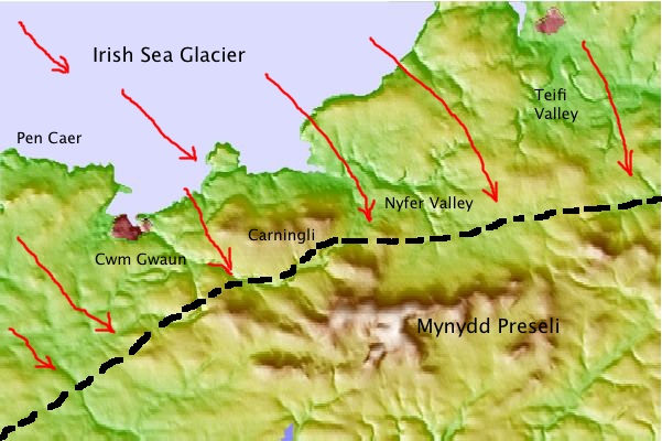
2. The line incorporates the "ice moulded tors" of the Fishguard - Dinas area and those of Pen Caer, but the fragile crags of Maiden Castle and Lion Rock, near Treffgarne, are outside the line.
3. The extensive fluvio-glacial deposits of the Newport - Moylgrove - St Dogmaels upland are explained as features associated with catastrophic ice wastage at the end of the glacial phase. So are the other meltwater deposits of the Gwaun Valley area, and Mathry Road near Letterston.
4. I'm assuming that the whole of the St David's Peninsula (Dewisland) was covered by glacier ice at this time. This is consistent with the distribution of tills around the coasts of the peninsula.
5. Cwm Gwaun and the other channels of the Gwaun - Jordanston channel system are all relics of earlier glacial phases, but they were used again by marginal and sub-marginal meltwaters during the Devensian. I think that the ice edge ran approximately along the route of the Gwaun Valley.
6. The Carningli-Dinas upland ridge was overridden by ice coming in from the NW. Maybe the highest point on Carningli remained above the ice as a small nunatak.
7. One big problem remains to be resolved. Did the ice override the Carnedd Meibion Owen ridge, on the south side of the Cilgwyn depression, and did it press up against the northern flank of Mynydd Preseli? Etienne et al seem to think that the ice did not press that far south, and that there was a vast glacial lake impounded against the north flank of the mountain. I would like to see some deposits or shorelines that might prove that -- and I am inclined to the view that the tors of Carnedd Meibion Owen WERE overridden at this time, and that ice may have reached Carn Alw and even spilled over the ridge into the Cern Meini area. There are remarkably fresh glaciated pavements and slabs at both locations......
8. I'm increasingly convinced that this was a very short-lived advance, with the ice at its maximum position for maybe no more than a few decades. My reason for believing that is that there are no massive end-moraines in the region, and not even any obvious shorelines such as we would expect if lakes had persisted for centuries in key "impounding" locations.
More work to be done -- but I think we are getting there.....
Nice picture of the perched boulder on Carn Edward. Carn Arthur (W of Carn Meini)also has one that sits on the skyline directly N from Gors Fawr circle and appears to accentuate a finger of rock pointing to Carn Menyn.
ReplyDeleteWhether it was made by the gods (glaciation in modern terms) or man I am not sure.
Yes, I know the Carn Arthur perched block -- it's mightily impressive. Obviously thrown there by a mighty fellow called Arthur, probably during the battle against Twrch Trwyth! It's one of three fine perched blocks -- will do a post about them soon.
ReplyDelete