Well, this is fun! There has been quite a protracted discussion on a Facebook group page on the subject of Eglwys Fair -- shown on assorted old maps at grid ref SN07871 34816. The Church or chapel was dedicated to St Mary. The latest manifestation of St Mary's Church is in Cilgwyn, down in the valley and on the road from Tafarn y Bwlch to Newport. It's a Victorian structure (built in 1884), now deconsecrated and used as a family home. It's not clear when the original church was built on this site, but it was, like its predecessor and several others, built as a "chapel-of-ease" connected with the parish church in Nevern. George Owen (in 1603) said that the church in Cilgwyn was consecrated "within the memory of men now living" -- which probably means around 1550. Before the Victorian rebuilding, it is reputed to have been derelict and unused.
Nevern parish is a huge one, stretching from Nevern and all the way up to the Preseli watershed, and the site of "Eglwys Fair" on the side of the bare hill called Banc Du, could well be the original church assessed with Nevern in the taxation documents of 1291. It would certainly be more suitable for the use of parishioners from the Preseli Hills who would otherwise have had a trek of more than four miles just to get to church on a Sunday. It must have had a wealthy patron, but we have no idea who that might have been. Might it have been associated with the families of Gelli Fawr or Tregynon? Who looked after it? And was the church built of wood, or of stone? Whatever it was, there is no trace of it today, and of course it may have been destroyed and rebuilt several times between 1200 and 1500 during the ongoing conflicts between the Welsh princes and the Anglo-Norman invaders who were seeking to maintain their hold over the barony of Cemais. It's also interesting to speculate that whoever was the patron of the church might also have managed the "deer park" on Waun Mawn and might have built the stone walls and straight embankments that are still prominent in the landscape near the Gernos Fach farm track.
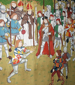
Now let''s get on with some serious fantasising. It's known from the ancient records that when Henry Tudor landed near Dale in August 1485 he marched northwards and spent his first night in the farmhouse of Fagwr Lwyd. It's now in ruins, and its grid reference is SN08272 35171. It's very close to Waun Mawn. There is a tradition that Henry worshipped in "Eglwys Fair" before marching on the next day towards Aberystwyth -- and we now know that this church must have been the one on the side of Banc Du. And another tradition is that the army (which was at that stage quite small) camped on Cnwc yr Hydd. That would make a lot of sense, since the "dolerite plateau" and the lower shelf on which the putative Waun Mawn stone circle might have been located, were both well drained and safe from any attack, given their domination of the surrounding landscape.
So here is my fantasy. The Waun Mawn stone circle (if there ever was one) was dismantled and taken away by Henry Tudor's army, who carried it with them to Bosworth Field because it embodied the spirits of the ancestors. And it was because they were accompanied by the stones that the knights and their followers enjoyed divine intervention, so becoming triumphant over wicked King Richard and leading to the establishment of the very Welsh Tudor dynasty. That's my story, and I'm sticking with it............

PS. I say above that there is "no trace" of the old church on the side of Banc Du, having searched on the common, outside the fence. But Vanya suggests that the location shown on the map is inaccurate, and that the church was below the old quarry, inside the area new enclosed. And sure enough, there is a faint trace on the satellite image of a rectangular feature measuring c 15m x 5m, aligned more or less N-S. She tells me that this church orientation was common in the Celtic Church, although later church building used the E-W tradition. She says that there was a trace of stone footings here prior to 1912, and that this was recorded in some RCAHMW document as yet unidentified........
Nevern is the centre of the known universe!
ReplyDelete