THE BOOK
Some of the ideas discussed in this blog are published in my new book called "The Stonehenge Bluestones" -- available by post and through good bookshops everywhere. Bad bookshops might not have it....
To order, click
HERE

Wednesday, 31 October 2018

The Kellaway Hypothesis

Suggested pattern of ice flowlines for the Anglian Glaciation.  


We should all take this map seriously.  It shows -- in modified form -- the essential features of the reconstruction by Geoffrey Kellaway and his colleagues in 1975 of the ice cover and ice directions in the Celtic Sea arena during the Saalian (Anglian) glaciation.  We can assume that this was the Greatest British Glaciation (GBG) -- at least in this arena.  Maybe things were different in the North Sea arena.

The reference and abstract for the paper are given below.

Kellaway and his colleagues were concerned about the "English Channel Glacier" -- arguing that ice that came in from the west affected many of the English Channel /Manche coasts.  Let's leave that argument to one side for the moment, and concentrate on what happened out in the Celtic Sea.   On the above map I have drawn a suggested ice limit between the tip of SW England and the NW tip of Brittany.......... and assumed that the English Channel may have been ice-free.  That, of course, is a matter for debate:

https://brian-mountainman.blogspot.com/2018/10/glaciation-of-english-channel.html

This is the original map from the paper by Kellaway et al (1975)

Kellaway and his colleagues appear to have been quite correct in their suggestions that ice (1) reached the shelf edge; (2) completely overrode the Isles of Scilly; (3) impinged upon the coasts of Devon and Cornwall and probably merged with ice from local ice caps; (4) moved both towards W and E from an ice shed situated over SW Ireland; and (5) pushed from the west with sufficient power to force its way into the Bristol Channel as far as Somerset and Wiltshire and maybe to cut off the supply of Irish Sea ice to the south of St George's Channel.  Without this massive pressure from the west it is difficult to see how and why an Irish Sea Glacier in the Celtic Sea would have had a sufficient surface gradient for lateral spreading almost 200 km to the east of its central flowline -- always assumed to have been broadly NNE -- SSW in the Anglian  glaciations.  In the Devensian glaciation it seems clear that the ice did not press so far to the east, but the overall pattern of flow lines might have been similar. The propose ice shed is shown with the broad yellow line on the top map.

Because this glacial episode occurred around 450,000 years ago, it is difficult to find traces of it on land, and equally difficult to find traces in the very dynamic submarine environment.

With mich more work still be be published by the BRITICE project, it will be interesting to see whether there are clear traces of pre-Devensian glacial deposits in the Celtic Sea -- and interesting to see whether these are derived from the Irish Sea Glacier or whether they have come from Ireland and from an ice dome or ridge based on the Celtic Sea platform itself.

It will also be interesting to see whether modelling work confirms that accumulation here near the SW edge of the British and Irish Ice Sheet could have been sufficient to maintain an ice sheet in approximately the position indicated.

In the meantime, let's refer to this as the "Kellaway Hypothesis" and see whether anybody will take it seriously, either for the Anglian or the Devensian.

================


http://rsta.royalsocietypublishing.org/content/roypta/279/1288/189.full.pdf

Phil. Trans. R. Soc. Lond. A. 279, 189-218 (1975)
The Quaternary history of the English Channel
By G. A. Kellaway, J. H. Redding, E. R. Shephard-Thorn and J.-P. Destombes


Abstract

Several lines of evidence for former glaciation of the English Channel are considered. These include the following major geomorphical features: (1) extensive areas of flat featureless sea bed bounded by cliffs with residual steep-sided rock masses rising about 60-150 m above them, (2) terrace forms bounded by breaks in slope or low cliffs, (3) palaeovalley systems related to the present land drainage, (4) enclosed deeps (fosses); all except (3) may be attributed to a glacial origin. The distribution of erratics on the Channel floor and in the modern and raised beaches of its coasts are attributed to widespread Saalian glaciation. This glaciation was responsible for the deposition of morainic material at Selsey and the damming-up of glacial Lake Solent. The so-called ‘100 foot raised beach’ of west Sussex is now re-interpreted as a fluvioglacial deposit laid down at the northern margin of the English Channel ice. It is thought that at the height of the Saalian glaciation mean sea-level fell to between 90 and 180 m below o.d. and that for a time the ice was grounded near the western margin of the continental shelf. Possible reconstructions of the limits and main movements of the Weichselian and Saalian ice sheets covering the British Isles and English Channel are included.

The quarrying roadshow hits Belgium


Thanks to Chris for sending some info and pics from an exhibition on Stonehenge in Tongeren (Belgium) which has been curated by none other that Prof MPP.

The fantastical piece of artwork shown above seems to be one of the centrepieces of the exhibit -- not much mistaking of Rhosyfelin -- the artist has worked very carefully from photos of the rock face.  It's all in there -- the ropes, the levers, the rollers and the triangular sledges with monoliths mounted crossways.  Here is a close-up of the centre of the image:


Here is another image, with a very hairy fellow and his lovely lady wife about to cart off something that looks suspiciously like the 8-tonne monolith which caused all the fuss in the first place -- but conveniently reduced to manageable proportions.


Then we have a motley collection of stones reputedly collected from the Carn Goedog "quarry" -- apparently these are now objects of veneration.


Chris has kindly translated the captions as follows:

"3300-3000 BC - Carn Goedog
SOFT WEDGES
These ragged edged stones were used as wedges to prise pillar shaped blocks of bluestone from the quarry of Carn Goedog in Wales. They were later brought to Stonehenge.

The sides of the wedges display traces of use: people drove them into the cracks between the pillar shaped blocks to prise them loose.

The wedges are of shale which is much softer than the hard dolerite of the bluestones. Maybe people hoped in this way to avoid damaging the bluestone pillars. Probably the stoneworkers also used wooden wedges and hammers, and ropes. The objects made of organic materials are not preserved."

======================

So just when we thought that some common sense might be breaking out, we get all the usual fantastical stuff yet again, in an exhibit put together at vast expense.  Even the nonsense about soft shale wedges is in there;  but surely that must be a practical joke, designed to test just how gullible the people of Belgium really are..........

Well, we already know how gullible museum curators are.  Enjoy!
==================================
Here is the museum publicity, flagging up that the exhibition is open until next April:

STONEHENGE - BEYOND THE MYSTERY

https://www.galloromeinsmuseum.be/en/exhibitions/temporary-exhibitions/stonehenge-voorbij-het-mysterie

13/10/2018 - 21/04/2019

2500 BC. An awe-inspiring structure was built in southern England. Circular, like the sun. With huge upright stones. The structure is now known as Stonehenge. Learn everything about this monument thanks to this intriguing exhibition.

What exactly is Stonehenge? Why was it built there of all places? Who ordered the huge monument to be built? And how did the builders actually build it? Recent archaeological research provides interesting facts and astonishing insights, while raising further questions.

The Gallo-Roman Museum brings together all the available knowledge in a single major exhibition: interviews with archaeologists, high-quality 3D visualisations, superb scale models, ... Authentic burial finds bear witness to festivities, ceremonies and funeral rites that gave colour and meaning to the lives of Stonehenge people. Atmospheric films offer an insight into their culture.

Fall under the spell of Stonehenge: one of the biggest mysteries in human history.

Friday, 26 October 2018

Stonehenge and Pembrokeshire -- not before time, a reality check


The National Park's Archaeology Day is on 17th November this year, and the poster has just been published. This is rather interesting -- Prof MPP is talking, as usual, but his theme this time is:  "New Discoveries on the Preseli Hills."  No mention of Stonehenge.  He will of course talk about Stonehenge, but is there just a hint that there is a reality check going on?  How many more disappointments can he and his team put up with?  For that matter, how many disappointments can research grant bodies and charitable funders put up with, when reality so consistently fails to match up to the hype?

Here is a check-list:

Craig Rhosyfelin -- a so-called "bluestone quarry" falsified by the researcher's own dating evidence and otherwise hotly disputed

Carn Goedog -- ditto

Castell Mawr -- proposed as  Neolithic henge linked to the "quarries" and now shown to be A Bronze Age / Iron Age feature with no links to bluestones or Stonehenge

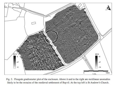
Bayvil -- ditto

Felindre Farchog -- prehistoric (?) enclosure / earthwork? A Neolithic henge site or quarrying settlement?  After a short dig, idea dropped.  Probably a medieval site

Carn Goedog (traces below the tor, on the edge of Brynberian Moor) -- Neolithic quarrymen's village?  Shown to be medieval.

Pensarn -- A site connected to Rhosyfelin?  Shown in 2016 to be a Bronze Age cist grave with nearby Iron Age site

Parc y Gaer -- A site linked to the Rhosyfelin "quarry"?  Shown in 2016 to be a Roman site -- probably a villa.

Waun Mawn -- strongly flagged up as the site of "proto-Stonehenge"  -- full results awaited, but apparently no links with bluestone quarries or with Stonehenge.

Bedd yr Afanc -- suggested as another proto-Stonehenge site, but previous excavations have shown up no signs of a henge or stone ring.

Wouldn't it be nice of Prof MPP could do a whole talk without once mentioning Stonehenge, and just concentrate instead on describing his digs and flagging up the very interesting prehistoric features which we have in Pembrokeshire?

The times they are a'changing............

Castell Mawr and the curse of Stonehenge


This paper places on record the excavations undertaken at Castell Mawr in 2012 and 2013.  At the time Prof MPP and his team were very keen indeed to establish solid links between prehistoric features in the Brynberian / Crosswell area and Stonehenge, with -- as we all know -- frequent pronouncements on what the next great leap forward was going to be.  The work was part-funded by the National Geographic Society, so spectacular results were anticipated..........

Use the search facility on this blog to find earlier posts.

Parker Pearson, M., Casswell, C. and Welham, K., 2017. ‘Excavations at the Castell Mawr Iron Age hillfort, Pembrokeshire’, Archaeologia Cambrensis 166, 141–73.

The article is freely available here:

http://eprints.bournemouth.ac.uk/29616/1/AC166%20141-173–Pearson%20et%20al.pdf

Abstract

Castell Mawr is a small hillfort in the community of Eglwyswrw, Pembrokeshire. Thought to have been built on a Late Neolithic henge, it was investigated with four trenches in 2012–13. These excavations revealed that Castell Mawr’s main period of construction and use was in the Earliest/Early Iron Age during the late eighth–late fth centuries BC with hints of an earlier human presence on the hilltop in the Late Mesolithic and Bronze Age. No definite evidence of any Neolithic activity was found, however, and the earthworks all date to the Iron Age. The hillfort’s Iron Age sequence started with a roundhouse, followed by a pair of concentric timber palisades built during the late eighth–late fth centuries BC. An enclosing rampart was constructed around the hilltop, followed by a cross-bank. The final activity post-dating the cross-bank dates to the fifth century BC, slightly earlier than or contemporary with initial construction at nearby Castell Henllys. The Castell Mawr/Castell Henllys sequence confirms Murphy and Mytum’s (2012) model for long-term processes of settlement development in west Wales.

In their Introduction the authors say: 
The possibility that Castell Mawr might have initially been constructed as a Neolithic henge led to a research programme of earthwork and geophysical survey and excavation of this site in 2012–13 by the Stones of Stonehenge project. The hillfort lies close to two sources of Stonehenge bluestones, one almost 4 kilometres to the south at Carn Goedog (Bevins et al. 2013) and the other just a mile away to the south at Craig Rhos-y-felin near Pont Saeson, Nevern (Pembs.) (Ixer and Bevins 2011; Parker Pearson et al. 2015). Thus it was thought that identification of a Neolithic henge beneath the earthworks of the hillfort might shed light on the social and economic context of the locality from which many of Stonehenge’s bluestones were sourced.

So there is no doubt where the authors were coming from or about what motivated them, so it is to their credit that following the presentation of the finds from the dig they admit that it was all a wild goose chase.  MPP says this in the conclusion to the paper:
There is little evidence of Neolithic activity, as had been anticipated, and the OSL dates from the outer earthworks indicate that these were not constructed until the Iron Age. Thus it is highly unlikely that Castell Mawr was ever a Neolithic henge.

But then, in talking about the local setting of Castell Mawr, MPP cannot resist popping this in: Another site with radiocarbon dates from this same Earliest/Early Iron Age period is the bluestone source at Craig Rhos-y-felin, Nevern, where a small, open site without any evident above-ground structures was occupied probably occasionally during the period from the late eighth to the fourth century BC (Parker Pearson et al. 2015, 1342, table 1). 

That is completely gratuitous and meaningless in the context of Castell Mawr -- he might just as well have cited every other site in north Pembrokeshire with radiocarbon dates falling into approximately the same time slot.  But the tactic was, and still is, to keep on mentioning the putative bluestone quarries, even where there is no reason whatsoever for doing so, so that the myth of their existence and their "importance" is kept alive.


Bayvil and the curse of Stonehenge


There's a new article on Bayvil, written by  Prof MPP, Kate Welham and Chris Casswell and published in Archaeologia Cambrensis.  It's free to view and download from the Academia web site.  Details:

https://www.academia.edu/37605860/A_Late_Bronze_Age_ring-fort_at_Bayvil_Farm_Pembrokeshire?auto=download&campaign=weekly_digest

A_Late_Bronze_Age_ring-fort_at_Bayvil_Fa.pdf

MIKE PARKER PEARSON, CHRIS CASSWELL and KATE WELHAM with contributions by Rob Ixer and Ellen Simmons (2018)
A Late Bronze Age ring-fort at Bayvil Farm, Pembrokeshire
Archaeologia Cambrensis 167 (2018), 113–141

The paper reports on the finds from a dig in September 2014.  For earlier blog posts on Bayvil, use the search facility.  It's worth reminding ourselves that the work at Bayvil was flagged up by Prof MPP in his September 2014 talks as the possible or even probable location for "proto-Stonehenge", since it was already clear at that time that the radiocarbon dates for Rhosyfelin were not coming out as expected.  So the search was on for a location for the "parking up" of all those lovely bluestone monoliths from Rhosyfelin for 400 years or so, prior to removal to Stonehenge.  Having drawn a blank at Castell Mawr, Bayvil was the next place on the list.  The authors of this paper are a bit coy about this background scenario, saying just this in their introduction to the article:

"An assessment in 2006 by Dyfed Archaeological Trust concluded that this 70m-diameter circular ditched enclosure is probably of Iron Age date but it has also been suggested that it might be a segmented- ditched enclosure — an early type of Neolithic henge (Driver 2007, g. 18)."

But be in no doubt, dear reader -- this was not an investigation designed to tell us more about the Bronze Age and the Iron Age in Pembrokeshire.  It was all about Stonehenge and the MPP narrative. Quote:  Investigations at Bayvil Farm were carried out as part of the Stones of Stonehenge project, researching the origins of Stonehenge’s bluestones within the area of the Preseli hills in north Pembrokeshire. The research in 2014 was supported with a grant from the National Geographic Society.  And be in do doubt that the researchers were hugely disappointed by what they found.

The paper is detailed and nicely laid out, with additional specialist inputs from Rob Ixer on pottery shards and from Ellen Simmons on plant remains.  So it clearly does make a contribution to the local archaeology database.  This isn't the place to review the article in detail.

So to the conclusion to the paper:
"The ceramic and radiocarbon-dating evidence indicates that this site is not a Middle-Late Neolithic enclosure of the type described as a segmented-ditched formative henge. Instead, the sequence of radiocarbon dates in the ditch and the Late Bronze Age plain-ware pottery within the secondary and tertiary layers of the ditch demonstrates that this enclosure ditch was dug probably in the late twelfth- eleventh century BC and then silted up probably within the tenth century BC. A probable roundhouse wall-trench and a pit with a flint scraper produced radiocarbon dates indicating activity within the enclosure probably in the late eighth-sixth centuries BC. This site’s use thus spans the Bronze Age/Iron Age transition though occupation and use may well not have been continuous."

That's all very fine.  Let it go, and move on, folks..........

But in the final paragraph of the paper the curse of Stonehenge strikes again.  The authors cannot resist dragging it in.  These are the authors' concluding words:

"...........the majority of other Late Bronze Age ringworks appear not to have had any local Neolithic monument to inspire their construction. Even so, the similarity of form between ringworks and henges is close enough to suppose that ringworks referenced an ancient Neolithic past. Given the location of Bayvil Farm just 5 kilometres north-west of Craig Rhos-y-felin, a bluestone source for Stonehenge, its construction could possibly have drawn on mythic histories relating to events of two millennia earlier. Similarly, the geometric plans of the Early Iron Age concentric palisades and enclosing ramparts at Castell Mawr, 3 kilometres south-east of Bayvil Farm, could have continued that revived link with a much more ancient past."

Bringing in Rhosyfelin and Stonehenge is completely gratuitous and more than a little nonsensical.  Pathetic, even.  Oh dear  -- why would a Bronze Age ringwork need to be "inspired by" a local Neolithic monument or to "reference" an ancient Neolithic past?  And what's all this about mythic histories and memories of events two thousand years earlier?  And because something has a circular plan, does that mean it continues a revived link with a much more ancient past?!   Archaeological gobbledeygook.

This sort of does thing nothing at all to enhance the value of a perfectly sound paper.  On the contrary,  it devalues it -- I'm surprised that the editor of the journal allowed its inclusion.  But there you go -- the editor is probably also infected by the curse of Stonehenge, so a degree of understanding and even sympathy is in order.

Thursday, 25 October 2018

Stonehenge -- much ado about nothing much?

The old ruin -- just a small local aberration of no great significance?

Stonehenge has of course been flagged up for many years as one of the key prehistoric sites in the world, on a par with the pyramids and Carnac and Gobeki Tepe -- hailed for the technical genius of its builders and as a masterpiece of social organization.  I have always thought that in its landscape setting it is not that impressive -- on a gentle downland slope and not even visible from a great distance away.  It's part of a landscape full of prehistoric features of many ages and types -- and it is often represented as being the centrepiece of that landscape and as the culmination or pinnacle of Neolithic and Bronze Age megalithic building.

But ....... as many have noted, it might well never have been completed, and the idea of the "immaculate Stonehenge" is not just being questioned by people like me, but also by mainstream archaeologists who know Salisbury Plain and its prehistoric features very well indeed.  The myth of the miraculous and wondrous Stonehenge is maintained by those who make a business out of it, like English Heritage and certain senior archaeologists, and those who like to think that it has some great scientific or spiritual purpose.  Prof MPP even promotes the idea that it is the ultimate symbol of political unification -- and much of his work in recent years has been devoted to trying to prove that hypothesis.

And of course the old ruin has been accorded a vast "artificial significance" because there has been so much digging there.  If you think about it for a moment, it is quite possible that other sites which have never been excavated at all may actually be of much greater significance in the development of prehistoric culture,

When I started, the other day,  to calculate the amount of work that went into the construction of Foel Drygarn (rather a small fortified site), I was struck immediately by the sheer scale of that operation (14,000 tonnes of stone shifted) as compared with the amount shifted at Stonehenge.  There, even if there were 80 sarsen stones and 80 bluestones, the total weight of stone built into the monument was not in excess of 2,000 tonnes.  Small fry indeed, and when we look at the scale of some of the larger hillfort sites like Maiden Castle or Oswestry, or even Silbury Hill.  (The main reason why it is famous and deemed to be significant is that for the last 100 years or so people have been gobsmacked by the wonderful story of the human transport of the stones from the Vale of Pewsey and North Pembrokeshire.  But if we place that myth to one side, what are we left with?)

I reckon that if we look at evidence rather than hype, we can well conclude that Stonehenge was just a small local aberration.  Far from attracting people from all over the British Isles, who travelled hundreds of miles bearing with them the stones of their ancestors, it was probably just one of those places that people passed occasionally and where they had a good time if there was a BBQ going on at Durrington Walls.  They probably asked the locals, while they were still sober enough to be interested, what was going on down the road.  "Oh, that weird collection of stones!" might well have come that reply.  "That's just Uncle George's mad fantasy.  He just started building it so that he could use up all those stones that were lying around.  Now that he's dead, the family'll soon run out of enthusiasm and energy, or forget what it was meant for, and get back to building nice round burial mounds like the rest of us.........."

Tuesday, 23 October 2018

The prehistoric quarries at Foel Drygarn


Above is a drone image (courtesy Iain P) of one of the most famous prehistoric sites in Wales-- Foel Drygarn (the bare hill with three cairns) at the eastern end of Mynydd Preseli.  There are four different components to the site:  

1.  the three prominent hill summit cairns, believed to be Bronze Age burial mounds;
2.  the defensive embankments and walls associated with a defended settlement, assumed to be Iron Age;
3.  the multiple pits, hollows or little platforms believed to mark the sites of around 270 huts;
4.  the rampart of crags running across the southern part of the fortified site.

Iain has made available some fabulous drone footage of the site,  here:


In the abundant literature on the site the crags are hardly ever mentioned, except maybe for a passing mention of their scenic beauty, or maybe a reference to the fact that they are "natural features used to enhance the defensive capabilities of the site".  The Coflein record is typical:


I'm rather intrigued by all of this, in these days of prehistoric quarrying mania, since nobody seems to have asked the question "Where did all the stone needed for these constructions (the cairns and the embankments) actually come from?"  A lot of stone was needed, as I have pointed out in two 2017 posts:


Let's look at stone quantities.   Each of the burial cairns has a diameter of c 20m and a height of c 4 m.  Reduce to a box of dimensions 15 m x 15 m x 3 m.  The volume of stone contained in each one is  675 sq m, giving a solid rock weight of 1822 tonnes.  Allow for "open work" air spaces occupying 20% of each mound, and the weight of stone contained in each mound becomes c 1458 tonnes.  Using a figure of 2.7 tonnes per cubic metre, the total weight of stone in the three mounds is therefore approx 4,374 tonnes.

Add to that the weight of stone contained within the defensive mounds.  The total length of the defensive embankments is between 950 m and 1000 m.  The embankments vary quite substantially in their cross-sections, but let's take an intelligent guess at a base 5 m wide and a height of 3 m.  Reduce to a box of dimensions 1000 m x 2 m x 2 m.  That gives a solid rock volume of 4,000 sq m and a weight of 10,800 tonnes.  Reduce by 10% to allow for incorporation of earth and rubble -- and we arrive at a total of 9,720 tonnes for the embankments.

So our grand total for stone required in the construction of this site is around 14,094 tonnes.  That's  a lot of stone.  Where did it come from?  It's pretty obvious -- from the on-site quarries on the hilltop.  Nobody with any sense would want to carry stone uphill  from the surrounding lower moorlands anyway, and economy of effort must have been just as important in prehistoric times as it is today.

So what is the physical evidence of prehistoric quarrying on the site? There is actually a great deal, and I have been up there today to have a look.


At the outset, it needs to be said that a lot of the stone collecting on this site has been opportunistic in the sense that it has involved gathering up stones from pits hollows, rock outcrops and surface litter here, there and everywhere.  Some of the stone from the levelling of hut platforms or pits has clearly gone into the stone embankments. A section of the outer embankment to the NW of the three cairns has been made of stone picked up from broken outcrops of volcanic ash in the immediate vicinity.  Immediately adjacent to the three cairns, and only about 20m away from them, we find a series of low cliffs of dolerite (unspotted) which are abraded and well weathered, but which have clearly not had fresh rock pillars, boulders or slabs extracted from them -- but the accumulated scree which once existed on their southern and eastern flanks has virtually all been taken away. One can see the extraction pits quite clearly, and in several locations one can see that all manageable (small) fragments have been removed, leaving behind all of the larger (greater than 100 kg) blocks and slabs. There has been selective extraction of handy materials on a substantial scale.

To the west of the main entrance into the fortified area we find the most spectacular crags on this isolated mountain summit. They are made of several different rock types, including dolerite, volcanic ash, and rhyolite.  The group of volcanic ash rags closest to the entrance point have clear signs of rubble and stone extraction on a high terrace, whereas the more spectacular crags to the west, which must originally have had thick accumulations of rockfall debris and scree on a lower terrace, much of which has been removed.  The extraction pits are clearly visible, separated by ridges of grassed-over rubble c1m high.  the trackway along which this extracted debris was carried is still used as the footpath to thus day, running eastwards towards the place where the southern entrance of the fort was located.

From a close examination of the crags and the extraction pits beneath the vertical or steeply-sloping rock walls, it's clear that no stone was physically levered away from the living rock. The stone gatherers were not interested in big pillars or monoliths -- all they wanted was the broken rock debris.  So maybe we should not call this a quarry at all -- maybe just a stone collection site, used on a substantial scale.  But maybe, since there are clearly still traces in the landscape of all this extractive activity, with 14,000 tonnes of stone shifted, the word "quarry" is right after all..........? 


The surface of one of the burial mounds.  The great bulk of these stones, extracted from scree slopes, can be shifted by one man.

A remnant of vertical stonework, on the outside of the inner ridge, showing that the ridges were at one time formidable defensive barriers.

Dolerite rock face in the SE part of the settlement site, with virtually all of the rockfall debris removed for incorporation into the burial mounds.


At the foot of one of the eastern dolerite cliffs these huge boulders have been left behind, while all of the smaller material has been taken away.

The westernmost crags, shaped by periglacial and glacial processes.  Beneath these crags we find the most dramatic evidence of stone removal on a substantial scale.

Interconnected extraction pits on the lower terrace, beneath the western crags.

In some areas a litter of frost-shattered scree still survives; but most of this material has been removed for incorporation into the defensive embankments.

The inner defensive ridge at the western extremity of the defended settlement site.  there is a slight ditch on the inside, from which stone has been extracted.  The outer face is here almost 5m high.

So what does this site tell us about prehistoric quarrying in the Preseli hills?  Well, our ancestors knew all about minimising effort.  They used stone -- of manageable sizes -- as close to the source as possible.  They had no particular preference for one type of stone over another; here they have used at least three different local rock types without any sign that one was revered more than the others.  There does not seem to be any spotted dolerite here, imported from the nearby spotted dolerite outcrops of Carn Gyfrwy, Carn Ddafad-las  and Carn Meini.  Even in the Bronze Age and the Iron Age, when metal tools were available, there seem to have been no attempts here to extract slabs of rock from cliff faces.

And most important of all, although some of the stone extraction here must have occurred almost 5,000 years ago, the traces of the work in the landscape is still apparent.  There are no natural explanations for the features described above.  In contrast, what do we see at Rhosyfelin and Carn Goedog that can be attributed to quarrying or stone removal?  Nothing at all.

Monday, 22 October 2018

Glaciation of the English Channel


"What glaciation?" I hear you cry.  "There wasn't one!  There could not possibly have been one......"

Well, maybe it's time to bring Geoffrey Kellaway in from the cold.  We have spoken on this blog many times about Kellaway's famous article in "Nature" -- in which he talked about the glacial ransport of the bluestones from Pembrokeshire to Stonehenge. He was vilified for that, particularly by the archaeological establishment.  But he was also vilified for another paper, published in 1975, in which he and fellow authors Redding, Shephard-Thorn and Destombes argued that ice from the west may well have pushed into the English Channel during at least one of the pre-Devensian glaciations.   The paper was published in the "Philosophical Transactions of the Royal Society"  -- it was difficult to get at, and was not widely read.  But now, thanks to the efforts to digitise classic papers and to make them widely available, it is on line, here:

http://rsta.royalsocietypublishing.org/content/roypta/279/1288/189.full.pdf

Phil. Trans. R. Soc. Lond. A. 279, 189-218 (1975)
The Quaternary history of the English Channel
By G. A. Kellaway, J. H. Redding, E. R. Shephard-Thorn and J.-P. Destombes

Abstract

Several lines of evidence for former glaciation of the English Channel are considered. These include the following major geomorphical features: (1) extensive areas of flat featureless sea bed bounded by cliffs with residual steep-sided rock masses rising about 60-150 m above them, (2) terrace forms bounded by breaks in slope or low cliffs, (3) palaeovalley systems related to the present land drainage, (4) enclosed deeps (fosses); all except (3) may be attributed to a glacial origin. The distribution of erratics on the Channel floor and in the modern and raised beaches of its coasts are attributed to widespread Saalian glaciation. This glaciation was responsible for the deposition of morainic material at Selsey and the damming-up of glacial Lake Solent. The so-called ‘100 foot raised beach’ of west Sussex is now re-interpreted as a fluvioglacial deposit laid down at the northern margin of the English Channel ice.   It is thought that at the height of the Saalian glaciation mean sea-level fell to between 90 and 180 m below o.d. and that for a time the ice was grounded near the western margin of the continental shelf. Possible reconstructions of the limits and main movements of the Weichselian and Saalian ice sheets covering the British Isles and English Channel are included.

In the article, there are a few strange things, and some of the information and contexts are very dated, having been overtaken by 45 years of subsequent research -- but the article is meticulous, cautiously stated, and full of fascinating observations and deductions.  One of the things that struck me, after all these years of forgetting about it, was the conclusion drawn with regard to glaciation traces and directions of Saalian (Anglian) ice movement.  Kellaway et al suggest two Saalian glacial episodes -- one which might be equivalent to the Anglian and the other to the Wolstonian.  Leaving that little matter on one side, this map is really quite fascinating:


It's a pity the map is so faint.  But note that what Kellaway and his friends were suggesting in 1975 was dismissed out of hand by almost all of those working in the Celtic Sea arena, and continued to be dismissed until within the last five years -- during which we have seen the maximum extent of glacier ice in the south-west approaches pushed further out, year by year, until it is now being positioned at the Celtic shelf edge -- just where Kellaway et al placed it in 1975.  The submarine evidence for that appears to be very strong.  

What is more, the directions of ice movement across Pembrokeshire and the Isles of Scilly are much more accurate than those shown in most recent research papers by the BRITICE team, and by placing an elongated ice shed over south-western Ireland and southwards across the Celtic Sea, Kellaway et al propose ice crossing much of the Celtic Sea and travelling NW towards SE -- as distinct from NE towards SW.    I have done a number of posts suggesting just such a situation, since that is the only way I can explain an ice edge at more or less the same altitude in Pembrokeshire and the Isles of Scilly, at least during the Devensian.

Variations of this map have been published many times by researchers associated with the BRITICE project.  The ice streams do not appear to accord with the evidence on the ground in Pembrokeshire and the Isles of Scilly.

One of the maps in which I have proposed a more realistic reconstruction of ice streams.  This accords much more closely with the map published in 1975 by Kellaway et al.

And another interesting thing is the ice lobe flowing into the English Channel from the west.  That makes perfect sense, if the ice was grounded close to the shelf edge 250 km SW of the Isles of Scilly and if the islands were completely inundated by ice, as suggested in my QN paper just published.

As some old Biblical fellow said once, a prophet is not without honour, save in his own country.........

========================

And here is another interesting item: 

Note added in proof, December 1974. Evidence for an early Quaternary glaciation of the Cotentin (Normandy) has recently been reported (Pareyn, Claude ‘La Quaternaire ancien de Saint Sauveur de Pierrepoint (Manche) Colloque, Caen, 9 September 1974. Sub- Commission on shore lines of northwestern Europe, INQUA).


Sunday, 21 October 2018

Strange boulders on the coast of Brittany


Coast of Brittany, to the west of Roscoff.  Granite territory, with low cliffs and coastal tors everywhere -- in many ways similar to the coasts of the Isles of Scilly.


Thanks to Daniel Praeg for drawing this to my attention during our discussions on the extent -- and thickness -- of ice in the Celtic Sea area during the glaciations of the Quaternary.  Here is one key article:

Citation:

Hallégouët, B. & Van Vliet-Lanoë, B. (1989). Héritages glaciels sur les côtes du massif Armoricain, France. Géographie physique et Quaternaire, 43(2), 223–232. doi:10.7202/032771ar

Rough translation:  Glacial traces on the coasts of the Armorican Massif, France


ABSTRACT
Relict ice rafting along the shores of the Massif Armoricain, France.  Occurrence of erratic boulders on the floor of the English Channel and along the shorelines of the Massif Armoricain is a common feature.  The distribution and the lithology of these erratics suggest ice rafting as the main transport mechanism and dispersion from local, regional and far away (basalt) sources areas.  They were transported either by river ice, sea ice or icebergs.  Drifting direction was controlled by prevailing winds assisted by tidal currents.  One episode of shore rafting has been identified in shore formations and associated to a short transgression close to the end of the last interglacial.  The observed relict sedimentary faciès is comparable to modern shore environments influenced by seasonal ice processes. Sea ice action on shore dynamics is believed to have taken place repeatedly during the Pleistocene along the coast of the English Channel.  It could partly be responsible for the shaping of the shore platforms in the area.

This is not easy territory for spotting erratic boulders -- the shoreline for mile after mile is littered with thousands of boulders, many of them heavily stained and covered with lichens and algae..... 

The area on the map below is one I know quite well, since we in Newport are twinned with the village of Plouguin, not far to the north of Brest.  Been there many times.......


I can pick up the gist of what is going on in French literature, but I'm rather concerned here that the assumption seems to be right from the outset of this article that the erratic (non-granite) boulders -- and there are many -- are all ice-rafted, and that the rafting episodes occurred during short-lived transgressions during the last interglacial.  Now we know that that was a time of relatively high sea-level -- somewhat higher that that of today. The implication is that it was warmer then then it is now -- and how much ice-rafted debris to we find coming onto the coasts of Western Britain and Brittany today?  How many erratics are recorded as coming onto these coasts as a result of floating ice transport since sea-level arrived at approx its present level, around 5,000 years ago?  As far as I know, none at all.

The authors of the paper ascribe the occurrences of boulders to the sort of coastal processes which David Sugden and I described in the "Coastal Geomorphology of High Latitudes" monograph in 1975.  They even invoke evidence of coastal currents and prevailing wind directions in order to explain how boulder-bearing ice floes reached the shoreline of western France during a warm interglacial.  It all seems rather forced, for two reasons:

1. The sorts of processes that are well known from the Arctic and the Antarctic today require very severe sea ice conditions with permafrost on land and sea ice anchored to the shore for at least six months of every year.  Such conditions cannot have prevailed during the last interglacial in western France.

2.   No account has been taken by the authors of isostatic and eustatic effects, which are complex to say the least. This is an area of complex isostatic and tectonic effects which have distorted palaeo-shorelines and raised beaches, but overall this is a sinking coast -- which means that during the last interglacial the shoreline might have been higher, with respect to current sea-level, than it is today. The paper below gives some further information.  

I think we have to assume that if these boulders were carried onto the coast either in ice floes or in icebergs and bergy bits blown ashore from the west, this happened much closer to the  peak of a glacial episode, and not during an interglacial.  Might this have been the Late Devensian glaciation?  That seems unlikely in view of the fact that the boulders and boulder beds are deeply buried under slope deposits and seem to be associated with raised beaches -- so it is much more likely that they date from either the Anglian or Wolstonian glacial episode -- or maybe both of them. 

If, as we have argued on this blog, the Celtic Sea was deeply inundated with glacier ice  on at least two occasions, and if on both occasions the ice reached the edge of the shelf 250 km SW of the Isles of Scilly, it is not unreasonable to speculate that the western coasts of France were isostatically depressed just as the floor of the Celtic Sea was.  Under those circumstances, if the sea was washing the western coast of France at approximately its present relative level, floating ice from the ice edge to the west could well have reached the coast, and it could well have dumped erratic boulders which were later incorporated into slope deposits and raised beaches.

And then we have the intriguing possibility that if the ice edge was only 100 km offshore, to the west of the tip of Brittany, might it have come even closer, and might it even have reached these low granite cliffs?  Watch this space.........


------------------------------------------------------------
Middle Pleistocene raised beach anomalies in the English Channel: regional and global stratigraphic implications. (2000) by B van Vliet-Lanoë et al
Journal of Geodynamics
Volume 29, Issues 1–2, January–February 2000, Pages 15-41

https://doi.org/10.1016/S0264-3707(99)00063-0

Abstract

Palaeo-shore positions help to evidence long-term eustatic changes and assist in the understanding of tectonic movements at a regional scale. Raised beaches anomalies exist in the Channel region and may result from deformations induced by neotectonic or by glacio-isostasy. The aim of this paper is to re-analyse, within their geodynamic context in the Channel and Dover Strait regions, the stratigraphy and the datings of palaeo-shores of Middle and Upper Pleistocene ages. This sector of Europe is characterised by strong geological contrasts and is controlled by two main geological boundaries: in the north, the Variscan Overthrust (corresponding approximately to the position of the Dover Strait) and, in the south, the Northern Branch of the Southern Brittany shearing zone. These two boundaries border a domain which seems to behave rather homogeneously on a large scale under the control of plate tectonics. Today, shorelines are subsiding north and south of this ‘Channel’ region. Episodic uplift largely controlled the open or closed status of the Dover Strait, especially after the Messinian and Early Quaternary, by reactivating Variscan structures. After 400 ka, global cooling allowed supplementary deformations in the area to be induced by glacio-isostatic rebound and clustered seismic activity during the phase of ice sheet building. Evidence of eight different transgressions dated by ESR from Oxygen Isotopic Stage (OIS) 13 to the end of OIS 5 shows the complexity of the sea-level records in a region unstable for isostatic and neotectonic reasons. Due to glacio-isostatic depression, transgressions are possible in late glacial times as well as during full interglacials. Most platforms were initially cut, during the Late Miocene, and seem to have been re-trimmed several times, especially by shore ice rafting since OIS 9. Regionally, the sea apparently rose to about the same level in O.I. Stages 11, 9 and 7. Glacio-isostatic and glacio-eustatic relative displacements of the sea level together with background tectonic movements have modified coastal positions and have temporarily altered the intensity of tidal currents. The oldest shoreline deposits are preserved only in subsiding areas, controlled by the deep crustal pattern. Neotectonics related to Variscan structure reactivation still dominates glacio-isostatic deformation and basin subsidence. The OIS 7 positive anomaly seems related to a regional relaxation event.


===================

PS.
More relevant info:

West, R.G . and Sparks, B.W. 1960. Coastal interglacial deposits of the English Channel. Philosophical Transactions of the Royal Society of London, Series B., Biological Sciences, No. 701, Vol. 243, pp. 95-133, 27th October, 1960 

Near Arromanches, at St Come de Fresne and Asnelles-Belle-Plage, two deposits showing a change from marine to freshwater sediments were investigated. The analysis of pollen and the Mollusca showed the prevalence of pine forest and its replacement by open steppe-like conditions as the marine regression occurred. After the regression, limon covered the freshwater deposits. The fossiliferous deposits are tentatively correlated with zone i of the Eemian Interglacial.  The relative land and sea-level changes indicated by the deposits are considered. It is concluded that in the English Channel, during the Ipswichian (Eemian) Interglacial, sea-level rose above its present height in zone f and fell below it during zone i. The Selsey-Brighton raised beach and the Normannien II raised beach are correlated with the same marine transgression. It is pointed out that if the Selsey-Brighton raised beach is to be correlated with the Monastirian II level of 7-8m, then this level should be correlated with the Ipswichian (Eemian) Interglacial.

This is an old piece of work, but it does seem to show that during the Ipswichian interglacial relative sea level on the coast of NW France was if anything higher than the sea-level of today.


Isles of Scilly -- new paper now published


This new peer-reviewed paper is now published, unfortunately with a serious mistake in it!  Figure 11, the crucial map showing the revised glacial limit, has had the bottom inadvertently chopped off it while it was being resized in the editorial process.  The map above is the correct one!

===========================


Brian John, 2018. EVIDENCE FOR EXTENSIVE ICE COVER ON THE ISLES OF SCILLY. Quaternary Newsletter Vol. 146, October 2018, pp 3-27.

ABSTRACT

Previous studies of the Quaternary sediments on the Isles of Scilly have suggested that the ice of the Late Devensian Irish Sea Glacier impinged upon the north coasts of the islands but that it did not extend much further south. There is also disagreement in the literature about whether any earlier glacial episode affected the islands, although a number of researchers have noted the presence of erratic cobbles in pre-Devensian raised beaches. The new field research, based in part upon examinations of exposures that might not have been available to earlier researchers, shows that erratic cobbles and pebbles are common in raised beaches and in early and middle Devensian brecciated slope deposits around all of the island coasts. The most parsimonious explanation is that they have come from disaggregated glacial deposits dating from at least one glacial episode (Anglian?) during which the islands were completely inundated by ice. Furthermore, coherent diamictons similar to those found on the north coasts of the islands, and in western and southern Pembrokeshire, are also found on the coasts of St Mary’s and St Agnes islands, indicating that the Devensian ice cover was more extensive than previously suggested. It appears that ice from the Celtic Sea pressed into the archipelago from the north-west and west, with lobes fingering into sounds and straits which are currently below sea-level. The diamictons, rich in striated and faceted erratic cobbles and pebbles from many different lithologies, do not appear to be primary tills; they are suggestive of an ice-margin environment in which disaggregation and redistribution of glacial and glaciofluvial sediments has occurred. The new interpretation of Late Glacial Maximum ice extent is consistent with other recent work which places the limit of the Irish Sea / Celtic Sea ice lobe around 250 km south-west of the Isles of Scilly, near the Celtic Sea shelf edge.

==================

You should be able to access the article here:

https://www.researchgate.net/publication/328413421_Evidence_for_extensive_ice_cover_on_the_Isles_of_Scilly/figures?lo=1

It can also be downloaded as a PDF.

The article was based on old-fashioned field observations during a week-long visit to the islands in 2016.  What I now hope is that some other researchers who have access to the full research facilities of various university departments will re-visit at least some of my sites and will confirm or dispute my suggestions and conclusions............

Thursday, 18 October 2018

Bedd yr Afanc -- the target for 2019?


Bedd yr Afanc is a passage grave on Brynberian Moor -- already much discussed on this blog. It is reputed to the the place where a terrible monster called an afanc was buried -- having become so bothersome to the locals that they at last slaughtered it and dragged it up onto the mountainside to be disposed of. A fitting parable, maybe........?

At the end of July, when MPP and the other archaeologists applied for permission to excavate at Waun Mawn, they also asked for consent -- and got it -- for the digging of three pits near Bedd yr Afanc.  But they didn't do any work there this year --my own guess is that they were so desperate to find something significant at Waun Mawn that they threw all their resources at that site instead.

But at Bedd yr Afanc they have done some surveying work and marked out assorted locations where they clearly want to dig.    Probably planned for 2019?  The marks are on the circumference of yet another putative circle which has the passage grave at its centre.  The diameter of the circle is approx 50m.  So they are clearly hypothesising that a stone circle was constructed around a pre-existing burial site, or that the burial site was built in the middle of a pre-existing stone circle.......

The circle stone circle obsession is as strong as ever........... but I wonder how long it will be before the funders of the work get fed up with all the hype and come to realise that they are constantly throwing good money after bad?  Eight years of hunting by the archaeologists, and nothing to show for it.

=====================

By the way, Bedd yr Afanc is built on a slight ridge that seems to be made of rhyolite, although the standing stones in the monument setting are all (from a cursory examination) made of the same dolerites, rhyolites and ashes as all of the other erratics littering the landscape.  Today I walked all the way across the moor to Hafod Tydfil, across many small mounds of moraine, and with till underfoot along the ancient trackway, but I didn't see a single cobble or boulder of spotted dolerite.  I am still working on the directions of erratic travel on the northern flank of the mountain.

Monday, 15 October 2018

Another biological process explains everything

Down goes a giant oak........

......... and up goes a 2-tonne monolith, ending up 2m above the ground surface


Well well, you could knock me over with a feather.  Just when I thought there was nothing much to say about extraction pits, bluestone monoliths, sockets and archaeological artifices, along comes a southerly gale, down goes a very large oak tree in the wood at the back of the house, and all is revealed.

What has happened is this.  In the Cilgwyn Valley there is an undulating surface of rocky outcrops and moraine, with large dolerite boulders and other erratics all over the place.  Over the millennia a mature woodland has developed, comprising oak, hazel, ash, holly, rowan, and sycamore for the most part.  The trees are safe as long as they do not get too tall, but if one tree has a crown above the rest of the canopy, it becomes vulnerable, and even top-heavy -- and eventually, in a gale, it will come down.

That's exactly what happened the other day. So what's all this got to do with archaeology?  Quite a lot, as it happens.  I have talked about biological processes before, in the context of the supposed "quarry" at Rhosyfelin.  Then, I was talking about the role of rocking trees and bushes, and expanding roots, in forcing slabs of bedrock to part company with the parent rock and to come crashing down, contributing the the accumulating mass of rockfall debris at the base of the slope.

https://brian-mountainman.blogspot.com/2015/03/the-rhosyfelin-shrubbery.html 

https://brian-mountainman.blogspot.com/2018/05/biological-processes-at-rhosyfelin.html

Here, near the Cilgwyn Waterfall, we are talking not about monoliths falling, but being lifted into the air.

When the tree came down, the root mass, which was of course horizontal, embedded into the stony ground, was tilted through 90 degrees, ending up vertical.  It carried up with it a large quantity of stones and boulders, the biggest of which is this dolerite "triangular pillar" weighing about 2 tonnes.  It has all the features of a highly abraded and weathered glacial erratic.  The moss-covered area id the part that was previously exposed at the ground surface.  So there it sits, about 2m above the ground surface, supported on a tangled pedestal of roots, soil, leaf mould, cobbles and smaller boulders.  There is quite a lot of clay too.  At the ground surface there is a large pit that was previously occupied by the root mass.  It's about 50 cm deep, and 1m x 3m in extent.  It contains a lot of debris, including smaller stones which were in contact with the large boulder that has been lifted into the air.  In another context these might be referred to as "packing stones".........  and the sides of the pit are not vertical but damaged and degraded by the occurrence -- in this case -- of a rather catastrophic event.


So what happens next?  Assuming no human interference, the "bluestone monolith" could remain on its pedestal for weeks, months, years, decades, centuries or even millennia.  It's not all that solidly "gripped" by roots, so my guess is that it will come down sooner rather than later, as rain washes away the finer material in the pedestal.

And what will people find in a thousand or five thousand years' time?  Well, they will find the hollow from which the boulder was extracted, with these smaller stones more or less where we see them now, probably filled with a mixture of slope wash debris, leaf litter and the rotted remains of the oak tree root system.  The full rotting process could take many centuries, since this is an oak tree.   If this woodland should be set on fire at any stage, either as a result of a lightning strike or because it is burnt for clearance purposes, there could be ash, charred fragments and even charcoal incorporated.   When the monolith does eventually slide off its pedestal and find its "final resting place" it is most unlikely to end up where it started off -- it could even be a few metres away, with a completely new alignment.  Then the soil surface will gradually build up around it, eventually burying both the boulder and the sediments beneath it.

So we end up with an extraction pit containing smaller stones and assorted sediments easily differentiated from those in the sides of the pit, dateable organic sediments, and a measurable gap between the extraction of the boulder and its eventual repositioning following the removal of its supporting pedestal.

This process is a perfectly valid one if we seek to explain what has been uncovered in the excavations at Waun Mawn.  But surely the Cilgwyn Valley contains a sheltered and prolific woodland, whereas Waun Mawn is a wild and windy -- and treeless -- moorland?  Not so fast, dear reader.  It was not always thus.

Not far away is the famous tor called "Carn Goedog", where MPP and his merry gang have been excavating.  That means "woodland carn", and the presence of bluebells around the crag is a pretty good indicator of mature woodland not so long ago.  The windswept appearance of the moorlands today is largely down to management -- and several centuries of grazing by sheep and other animals.    Gorse clearance by burning has played its part too.  Not far away from Carn Goedog, at the enclosed "summer settlement" of Hafod Tydfil, there are healthy mature trees growing in abundance, simply because they have been protected from animal grazing.  And at Waun Mawn itself, we know that it was once designated as a "deer park" and was used as such in the Middle Ages.  Deer parks did not exist on wild moorlands; on the contrary, they were densely wooded, so that deer, wild boar and other animals could be hunted with the help of abundant cover  by the lord of the manor and his cronies.

So there we are then.  The features at Waun Mawn which have excited certain archaeologists and left the rest of us rather unimpressed can all be explained by natural processes.  All we need are some dolerite boulders or monoliths littering the landscape, some mature trees and the occasional gale.


Sunday, 14 October 2018

Waun Mawn 2018 dig -- and some very naughty boys and girls

One of the pits after restoration

Part of the biggest pit -- covering an area of 198 sq m -- when it was open

It will be obvious to readers of this blog that I -- and many others -- are rather fond of the Waun Mawn and Tafarn y Bwlch neighbourhood, given that it is wild and beautiful up there, and it also contains something of a treasure-house of archaeological features.

When I saw the sheer extent of the 2018 Waun Mawn dig, I was immediately concerned about its impact on a specially protected area -- inside a National Park, inside an SSSI and inside a Special Area of Conservation too. That all represents -- in theory -- the highest level of protection possible under British law.  I wondered what the consent process was for archaeological digs of this type -- who does the applying, to whom, and how are consents issued?  Are there any inputs into the process from other interested parties like Wildlife Trusts or CPRW?  What judgments are made on costs versus benefits?  (In other words, does somebody make a judgment on whether the environmental damage is acceptable when set against the potential scientific or cultural value likely to come out of the dig?)  Further, what conditions are attached to consents, what monitoring is there, and what sanctions are there if the terms of the consent are breached?

Another view of "big pit" when open

I did a post on this topic back in September:
https://brian-mountainman.blogspot.com/2018/09/digging-up-waun-mawn-costs-and-benefits.html
and published a few photos of the open pits.

First, I asked the National Park whether they had issued a consent.  No, they said, the whole process is handled by Natural Resources Wales (NRW).  There is no input at all from Cadw, RCAHMW or the Dyfed Archaeological Trust -- and that's interesting in itself.  It doesn't appear that other bodies are even asked for their opinions.  Nobody apparently asked what the purpose of the dig was, or what the chances were of making significant finds.  I checked on the NRW web site for any trace of a consent, but there is no searchable database.  That means there is no role in the process for interested parties or the general public -- unlike the situation with regard to planning applications.  There is no public record that can be searched.  The only way to get information is to write in with a specific request.  So I banged in a letter.  After 20 days or so I got a reply, and it was very interesting indeed..............


It appears that the application to NRW was made on 30th July via the Barony of Cemais -- the landowner of the Preseli commons. That means that the Barony received the request from Prof MPP
and his team, approved it, and passed it on to NRW on his behalf. The application was in the form of a simple letter, asking for consent for "archaeological excavations" involving six trenches, each one no larger than 90 sq m, with a maximum area excavated totalling 540 sq m. The work was due to start on 2nd September, lasting for 3 weeks. There was no mention of the proposed depth of the trenches. The applicant stated: "Trenches will be excavated by hand. On restoration, they will be backfilled by hand with their soil, stones and turf so as to leave them in the condition in which they were found." Prof MPP also said on the application: "Vehicle use will be restricted to an ATV (all-terrain vehicle) provided by the National Park authority and driven by one of its staff, warden Richard Vaughan. The archaeological team will carry all equipment to and from the excavations on foot. They will park at recognised parking spaces and walk to the sites each day."
Consent for the operations was given on 8th August. (Consent Ref No: 2278324)  No conditions or monitoring requirements were added at the consent stage, and so it was a straightforward "rubber stamping operation" taking just a week and involving minimal scrutiny.

So to the dig itself.  It appears that the vehicle use restrictions were adhered to, and the dig was indeed completed without the use of mechanical diggers.  A lot of human labour went into it!   But this is what happened.......

Since NRW is clearly not very interested in checking that the terms of its consent have been adhered to, I offer it some assistance. In some cases it is quite difficult to determine where the boundaries are between the 2017 and  2018 excavations ("trenches" is the wrong word, because they are actually all quite shallow), and some parts of the 2017 digs have been re-opened.  But as far as I can see there are 15 new excavations (not 6), ranged around the circumference of the putative giant stone circle.   The total surface area involved in actual digs seems to be about 500 sq m, with approx the same area disturbed by soil and turf dumps, working traffic and vegetation clearance.  Most of the work has been done in the NE and NW quadrants, and the biggest areas stripped of turf are in the south, where one excavation covered 60 sq m, and in the SW, where one covered 198 sq m.  In the report sent to me by NRW, this is what their field officer said:

**  Following completion of the works the applicant contacted me to state that they had accidentally gone over the consented 540m sq. He calculated that they had in fact excavated 700m sq. The applicant apologised for this accidental event.
**  Unexpectedly dry weather this year will have undoubtedly hampered the reestablishment of the turves. I have not visited the site yet but will do so to assess if anything further needs to be done in terms of restoration.
**  A letter will be sent to the applicant informing them that, should any consents be issued in the future for similar work, they must ensure that the works adhere strictly to the terms of that consent.


MPP has been quite honest in admitting that the area excavated in Sept 2018 (probably including the reopening of some 2017 pits) is about 700 sq m.   I wouldn't argue with that, although one does wonder about how an area of 160 sq m could have been excavated "accidentally."   But what worries me more is that one of the pits -- at c 198 sq m -- is far in excess of the maximum size allowed under the consent; that the replacing of turves has been for the most part pretty slapdash; and that some excavated areas (including one area of about 8 sq m near the eastern limit of the investigated area) have not been reinstated at all.  All pegs, markers etc have been taken away, and the site was left clear of any litter -- so that's something to be thankful for.

All in all, I think the diggers have made a reasonable effort to tidy up after themselves, given that they had some pretty inclement weather to cope with in the last few days of the dig, when they were doing the reinstatement work.  But the fact of the matter is that they have not left the area as they found it, they have breached the conditions both in respect of the total surface area excavated, the maximum size of excavated pits,  and the number of new pits opened (15 instead of the requested 6).  They have also left some areas devoid of turf altogether.  I shall refer this back to NRW with a request that they should make a proper post-excavation site survey and require additional reinstatement work to bring it up to an acceptable level.

I shall also ask NRW whether they are satisfied that their "due process" has provided an adequate level of protection to this sensitive area,  given the requirements placed upon them in law.

Am I making a fuss about nothing here?  I think not.  Some of us have thought from the beginning that the environmental costs of this sort of work, within an area theoretically afforded the highest level of protection, always were far too high, given that this always was a wild goose chase.

A chaotic mess left adjacent to one of the recumbent stones at the north end of the excavation site


One of the areas where no reinstatement work has been done