Abermawr on the north Pembrokeshire coast is one of the most interesting -- and important -- Pleistocene sites in Wales, spanning a full glacial cycle. I described the sequence in detail in my doctorate thesis of 1965, and that description and interpretation has found its way into many subsequent publications. However, it is now a bit misleading, since the cliff exposure has changed in several important respects over the last 50 or 60 years. That's because the cliff has retreated in places by as much as 30m, exposing a broken ancient cliffline, part of which is shown in the photo above. We can see the fine-grained Irish Sea till at the top of the photo, but beneath it the blocky slope breccia is chaotic, non-stratified and virtually homogenous. Just one "stratigraphic unit". Now look below.
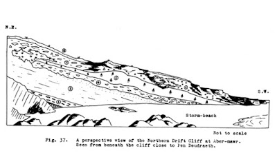
This was the 1965 sequence of sediments at Abermawr. At that time I recorded four facies of slope breccia or "main head" beneath the Irish Sea till.
Devensian deposits at Abermawr -- an idealised section through the sequence. Again, four facies of the "main head", with the finest of them (layer 3) referred to as "flaky gravels". It was assumed in 1965 (and this may still be correct) that these four horizons represented environmental changes during the early and Middle Devensian, prior to the onset of full-glacial conditions.
So all of these "facies" of the Main Head have been wiped out by coastal retreat and as the old broken up cliffline has been exposed bit by bit. You'll just have to take my word for it that this is what it all looked like long, long ago.........
Then there is another thing.
I have just noticed that on p 71 of the GCR volume for Wales, written by Campbell and Bowen in 1989, the stratigraphic sequence for Abermawr is said to include up to 3.6m of "water-worn gravels" between the "lower blocky head" and the "upper blocky head with scattered erratics", with all three lying beneath the Irish Sea till. This is completely wrong -- I have been looking at this site at frequent intervals since 1960, and I have never seen a thick layer of water-worn gravels here. There are water-worn sands and gravels (glaciofluvial deposits) in the southern part of the exposure at the north end of the bay, but even a cursory examination reveals that these lie stratigraphically ABOVE the Irish Sea till. The lower slope breccia or "head" was laid down more or less continuously, with some signs of occasional short breaks or pauses and one possible weathering horizon that may indicate an interstadial breaking an otherwise prolonged cold period, but I can say with certainty that I have never seen a Middle or Early Devensian water-lain deposit here a few cm thick, let alone 3.6 m thick!
In 1960-65 there was an exposure of what I referred to as "flaky gravels" which contained less blocky material than the layers above and below it, but I always assumed that this was one of four "periglacial facies" within the Main Head horizon, perhaps accumulated under less severe permafrost conditions. Shall we say that DQ Bowen was perhaps in too much of a hurry when he recorded what he thought was the sequence of deposits at Abermawr? Let's hope this inaccuracy has not caused too much confusion among generations of field trip students. At least the sequence is right in the QRA booklet of "classic Quaternary sites":
https://www.qra.org.uk/media/uploads/55fc8606ac7f8-UK%20Top%20Quaternary%20sites%20-%20a%20compilation%20-%20FINAL%20(v2).pdf
In the QRA Field Guide (2001) Kenneth Rijksdijk and Danny McCarroll referred to just one horizon beneath the Irish Sea till, which they described as a "locally derived breccia unit". That is what can be seen today -- the section has changed a great deal since 1960.
Another photo (taken today) of the breccia beneath the Irish Sea till. I now think that some of the variations in texture are related to the nature of the buried rock cliff that was being broken down, including lithology (which is quite variable hereabouts), structure and surface characteristics.


No comments:
Post a Comment