THE BOOK
Some of the ideas discussed in this blog are published in my new book called "The Stonehenge Bluestones" -- available by post and through good bookshops everywhere. Bad bookshops might not have it....
To order, click
HERE

Tuesday, 9 March 2021

Those damaged ring cairns


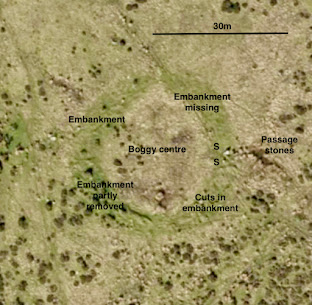
The Gernos Fach circular feature.  Is it a very large ring cairn, or some sort of henge?

 Thanks to Dave Maynard for supplying these drone images.  They are great!  The annotations are mine.......  As we mentioned in the last post, they are puzzling -- and not just because of the removal of material from parts of the embankments.  It will be interesting to compare these features in more detail with other circular features in the area -- of which there are several, even when we ignore the postulated "giant stone circle" so greatly beloved of MPP and his friends.

I am beginning to wonder whether they might be seriously old -- by which I mean early Neolithic.  But we must not get into the realms of speculation -- or we might get into trouble with serious archaeologists........


The Cnwc yr Hydd feature, showing the bank and the disturbed area on the 
northern section.

Monday, 8 March 2021

The damaged ring cairns at Waun Mawn


It's intriguing that the two ring cairns on Waun Mawn are either unfinished or else seriously damaged -- and maybe both........

The biggest one, which I call the Gernos Fach ring cairn, at SN 07708 34535, is not a very spectacular feature, since the embankment is generally only about 50 cms high.  That may be, of course, because it is very old and degraded.  But it's about 30m in diameter, and is very easy to spot on satellite images. The embankment is grassy and dry, and the centre is boggy with reeds here and there.  It may be that only two thirds of the embankment was completed, since there is no trace of it in the NW segment.  It's made of dolerite bloulders and stones, as distinct from the Cnwc yr Hydd ring cairn which is made largely of meta-mudstone and shale rubble.

There is a clear entrance on the eastern edge of the feature, with one stumpy standing stone apparently in position and another much larger stone that has almost fallen over.  There may be an entrance "passage" to the east of these stones, with a further six boulders roughly in two lines, and with a seventh stone -- probably fallen -- in the centre of the "passageway".  

The southern and south-western sections of the embankment have clearly been excavated and partly removed.  Why, and when?


The two entrance stones of the Gernos Fach ring cairn.

The ring cairn to the SE of the Cnwc yr Hydd summit cairn (at SN08321 34446) is a smaller feature, only about 11m in diameter, with an embankment made of meta-mudstone and shale fragments and an embankment that varies between 50 cms and 1m high.  There is a distinct hollow in the centre.  Most of the ring is complete, but in the northern segment there are traces of two overlapping circular features, each with a diameter of c 4m.  One of these is quite prominent, and may be a remnant of a hut circle.  But there has been a lot of debris removal from this northern segment, and the cutting shows up quite clearly on the satellite image.


The smaller Cnwc-yr-Hydd circle, with disturbance on its northern flank.

So why have both of these features been cannibalised rather than revered?    The cuttings appear quite fresh, so they may even have been created in historical time, within the last 200 years.

The impression gained from these features, and from many other prehistoric features in the neighbourhood, is that in Neolithic and Bronze Age times there was an active working community in this area, who used local stones in ritual stone settings.  But none of these settings (apart from the Pentre Ifan cromlech) is particularly impressive, and unfinished or poorly made monuments appear to be quite common.  So there was a megalithic culture here, characterised by enthusiasm rather than technological mastery.  There is no sign of any great preference for particular stone types or provenances; all of the monuments are built from stones which have been locally sourced.  There was never any need for quarrying;  stones could simply be picked up and used where found.   Parker Pearson's claim that “this was one of the great religious and political centres of Neolithic Britain” is not supported by any evidence on the ground. As I have said elsewhere, it follows that there is still no evidence of any connection between this site and Stonehenge.

PS.  I'm quite intrigued by the fact that neither of these ring cairns / circular enclosures is mentioned in the RCAHMW or Coflein records.  Other features on Waun Mawn and Banc Du are mentioned, but not these......... in spite of them being quite prominent and easy to spot on satellite imagery.

Friday, 5 March 2021

More rockfalls on the Newport cliffs


There has been another big rockfall on the cliffs at the northern end of Newport (Traeth Mawr) beach.  It's not as big as the last one I reported, but it has left a distinct cone about 5m high against the foot of the cliff face, where it now rests on part of the wave-cut platform.  The debris consists entirely of slabs and smaller fragments of local shale and mudstone, from high on the cliff face.

Not sure of the date of the fall, but it was probably in the first half of February 2021 during a spell of stormy weather.

So what's going on here?  there seem to be two main factors in th apparent acceleration of cliff face "events", both associated with global warming and climate change.

1.  There is now much more variability in wind directions than there was fifty years ago.  That means that northerly or north-westerly gales are much more common, with storm waves battering the cliff base and triggering collapse events.  Previously, these cliffs were rather well protected, and there was a barrier of broken debris at the head of the beach at around HWM.  This protective barrier has now been dissipated.

2.  Because of increased rainfall totals, and increased wetness in the winter months, the water table in the rock behind the cliff face is higher.  This means there is increased pore water pressure and also greater lubrication in fissures and fractures -- so that when storm waves are sending vibrations into the cliff,  and when air under pressure is forced into caves, cliff collapse becomes more likely.

In addition to this latest large-scale collapse, there are a number of smaller ones along the cliffline in the vicinity.


Wednesday, 3 March 2021

Waun Mawn and the search for "Proto-Stonehenge"


This is just a notification that I have today updated my article on Researchgate to incorporate some of my latest observations on the site of the imaginary "giant stone circle".  The article continues to attract a lot of reading traffic -- the number of reads has now reached 2,477.  That's gratifying, and it shows that not everybody is being swept along by the media hype and by the extraordinary claims being made by MPP and his team, on the telly and on the internet.

https://www.researchgate.net/publication/345177590_Waun_Mawn_and_the_search_for_Proto-_Stonehenge


Monday, 1 March 2021

Parc Mawr hut circle


Satellite image of the hut circle
 

Every time I go for a walk up on the mountain (or one of the mountains) I seem to find something new.  I don't know whether this one has been recorded before, but at Grid Ref SN03461 36952 there is a beautiful little hut circle on the south side of a prominent small tor.  It's quite easy to pick up on the satellite imagery, and it's located about 150m west of the prominent "flat" tor just outside the enclosed farming area.  It's about 500m from the Bedd Morris standing stone, and is best approached from the Bedd Morris road by the footpath across the common.

There is a prominent circular bank made of large boulders and cobbles and now almost completely covered with turf.  It's about 1m high, and the diameter of the circle is about 7m.  There is no obvious entrance, but there are signs of a gap (currently plugged with boulders) on the west flank of the rock outcrop, and on the north side of the circle circumference.

There is another enclosure on the eastern side of the "big flat tor" a little closer to the Bedd Morris road.  So this part of the Carningli - Mynydd Dinas upland was occupied in prehistoric times; virtually no part seems to have escaped the attention of these early settlers........


The hut circle tucked up against the flank of a small dolerite tor.


Waun Mawn -- the monoliths that got away


The western "recumbent monolith" at Waun Mawn, surrounded by disturbed turf from the archaeological dig.  A huge pit would have been required to stabilise this stone in an upright position.


The eastern "recumbent monolith" at Waun Mawn, which would also have required a massive stone socket  if it ever was a standing stone.....


I'm sure I'm not the only one to have noticed that in the recent 'Antiquity" article about Waun Mawn, Parker Pearson and his colleagues provide no evidence whatsoever that the two big "recumbent stones" reputed to lie in the "surviving" portion of the "giant stone circle" were ever standing.  They are big and bulky stones, each one weighing in at around 6 tonnes -- and far bigger than any of the standing or fallen unspotted dolerite bluestones at Stonehenge.  I think it can be argued that both stones are simply lying where they were at the end of the last glacial episode.  I shall continue to believe this, so long as nobody comes up with any evidence to convince me otherwise.......


The large recumbent stone on the dolerite plateau to the west of the Cnwc yr Hydd summit.  It's difficult to assess the precise dimensions, but it appears to be about 3m long, and almost 2m wide on one face.  It probably weighs about 6 tonnes.

On the dolerite plateau to the west of the Cnwc yr Hydd summit there is an extensive area of dolerite boulders and stone settings, with some rock outcrops, and a number of deep pits and small mounds and ridges.  It's difficult to assess what might be natural and what might be fashioned by Neolithic or Bronze Age tribal groups.  But one stone stands out -- a very large recumbent stone deeply embedded in the turf which is strikingly similar to the two large recumbent stones at the "circle" site about 450m away.  If the people who supposedly had grand designs for building a giant stone circle using unspotted dolerite pillars, and if they were supposedly capable of carrying stones from 4 km away, why did they ignore this one, which could easily have been transported 450m downhill across a relatively dry surface?  

And since the supposed stone-holes or sockets at Waun Mawn look as if they might have held stones no taller than 2m,  why did they also ignore the two small pillar stones that still lie in the turf no more than 50m away from the "circle"?  Nothing about this site makes any sense at all.......


The two small monoliths which would surely have been used in a stone circle at Waun Mawn 
if ever there had been one........ 

Finally, when I was up in "them thar hills" yesterday, I took a close look at the "slight mound" that is assumed by MPP and his colleagues to have some significance, associated with the western of the two recumbent stones.  I am convinced that this "mound" is entirely natural, since it is no more prominent and no more extensive than innumerable other small grassy mounds or undulations across the local landscape.  As I have mentioned before, the landscape of Waun Mawn and Cnwc yr Hydd is also pitted with innumerable hollows, some holding water and rushes, which are much more prominent that those at the "circle" site thatv are supposed to have held standing stones.


Current Archaeology joins the media circus

This supposed stone hole does not even have a pentagonal base -- and any comparison with 
stone 62 at Stonehenge is entirely fanciful.

Here we go again.  Current Archaeology joins the media blitz by simply regurgitating the press releases and repeating all the Waun Mawn speculations without offering a shred of independent scrutiny.  Have the people in charge of magazines like this simply lost the capacity to analyse for themselves anything that is presented to them?  Have they no way of identifying archaeologists who are in pursuit of their ruling hyopotheses?  It can't be that difficult.  After all, all you have to do is to apply the standards of common sense to the reading of an article in a journal..........but maybe nobody actually reads articles any longer?  The scale of the gullibility within the archaeology community in the UK seems to me to be quite staggering.......

https://archaeology.co.uk/articles/news/stonehenge-a-recycled-welsh-monument.htm

Here is just one of the bits of nonsense in the "Current Archaeology" write-up:

"...........the project also revealed that one of the empty holes at Waun Mawn had a pentagonal base, very similar in size and shape to Stone 62 at Stonehenge. Subsequent analysis of stone flakes recovered from the bottom of this stonehole suggests that its former occupant was made of unspotted dolerite, very likely quarried from the same location as Stone 62 and the other two unspotted dolerites that have been identified at Stonehenge."

When looking at this supposed stone hole, the average primary school pupil would probably ask why one particular stone at Stonehenge is supposed to have fitted into it, when many thousands of other stones scattered all over the UK would probably have fitted better.  Stone flakes recovered from the bottom of the stone hole are no different from the broken dolerite fragments scattered right across this landscape -- any speculation about quarrying and distant "shared sources" just does not make any sense.

And so it goes on.

I wonder if all of the articles in this journal are equally unreliable?