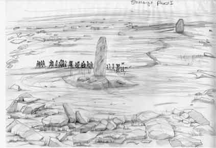
Reconstruction of the site of Stonehenge in ‘Phase 1′, before
Stonehenge, showing a rather too liberal scattering of sarsens in the
area (Picture courtesy of David Field at English Heritage).
Thanks to Tony for drawing this to my attention -- it's an interesting 2012 conversation between Edward Pegler and David Field, published on Ed's blog site here:
Reproduced below again, for anybody who might not be familiar with the site -- full acknowledgement as to the source.
Edward and I had an interesting debate on this as well, back in 2010 -- in the context of a chat about bell curves.
Over the last year or two there seems to have been a strong drift towards the idea that the Stonehenge sarsens were collected up in the vicinity of Stonehenge, and didn't need to be transported very far. We have touched on this before, many times, in this blog. I also support the idea strongly in my book, since I have seen no convincing evidence that the big sarsens were collected up and transported all the way from the Marlborough Downs, or from anywhere else more than a mile or two away. Geomorphologists like Mike Summerfield and Andrew Goudie have in general concurred with this.
==========================
The sarsens of Salisbury Plain – A conversation with David Field
Apart from the obvious ones at Stonehenge, are there many sarsens on Salisbury Plain? David Field thinks there are.
I went to see a talk before Christmas at the Devizes Museum, Wiltshire, England. It was given by David Field of English Heritage, and was all about the development of the landscape around Stonehenge through the millennia. After the talk I got into a brief e-mail conversation with Dr Field about the Sarsens of Salisbury Plain. This started really due to a question about just how many sarsens there were at Stonehenge before Stonehenge was built. For anyone who’s interested, here’s the full transcript.
David: I’m pleased that you enjoyed the talk. Yes, coupled with the recent work by Mike Parker Pearson and the Stonehenge Riverside Project there’s enough material accumulating to provide a new platform for Stonehenge studies for a while to come. I’ve attached the sketches of Stonehenge. There’s a lot wrong with them as you’ll no doubt soon notice, not least the missing bluestones, but we’ll work on this in the coming months and come up with something more precise.
Me: Just having a look at the sketches, they are lovely. Ok so there are a few details that are odd. But what strikes me as most odd is all the broken up sarsen lying around the area in Phase 1. I know it’s an idea that appeals to some but this amount of sarsen is very unlikely for Holocene Salisbury Plain. The evidence for it would be present as smaller sarsens not just in the Stonehenge area but widely distirbuted in the surrounding valleys due to solifluction. But perhaps more important to me seems to be the absence of large sarsens encorporated into the long barrows of Salisbury Plain. Comparison with the Marlborough Downs and the Cotswolds would suggest that such burial mounds would have used them.
David: Yes, the artist put too many in. I just wanted a thin scatter with a cluster by the mound. The next version will look a little different. There are, however, quite a few smaller sarsens around on Salisbury Plain and some were indeed incorporated into long barrows. Knook Barrow had a cairn of sarsen, Arn Hill long barrow had a standing stone, Corton long barrow had a ‘massive boulder’. Cunnington said that sarsens can be found all over the downs beneath the turf and that farmers plough them up in the area north of Stonehenge (Larkhill west of barracks) from time to time. There is a long barrow there (Figheledean 31-see attached) with three in the ditch and another six in a line where they were disturbed when the military built a rifle range. Quite a few around Bulford, aside from the Cuckoo stone (attached), Togstone and the one in the river, there is one from a round barrow that had a burial beneath an ‘immense sarsen’ and a number of others noted on early maps. One of the King Barrows formerly had a sarsen circle or kerb around it. Today the Imber to Chittern valley has many small boulders and cobbles on the slopes and in the stream and presumably many more were once visible when the area was cultivated.
As you rightly say, none of these are large in trilithon terms, but then neither are any of those on the Marlborough Downs where they rarely exceed a couple of metres – three at the most. The big ones there seem to have been reserved for the Cove and blocking stones at West Kennet. The survival of many on the Marlborough Downs can be put down to lack of agriculture (it’s a degree colder there than Salisbury Plain) for they get in the way of ploughs and soon get cleared and broken up or buried. You can trace the clearance process at Overton/Fyfield from undisturbed sarsens on the summits, to the clearance to field edges to create ‘Celtic’ Fields in the Bronze Age on the upper slopes, to the development of lyncheted fields that cover the sarsens around the edge in the Roman and medieval periods on the lower slopes. If the same processes took place on Salisbury Plain where there was widespread agriculture in Roman, medieval and post-medieval times there will be many other sarsens buried beneath the field lynchets.
So where did the big ones come from?”
Me: Not expecting a reply to this, but I guess the big sarsens must have been more common in the past in certain areas. This must largely depend on ?Miocene distribution of groundwater flow during southern England’s sub-tropical flat phase before the Plio-Pleistocene uplift. Extensive silcrete development, I guess, would be along natural fluid-flow pathways in the ground, so it would probably occur in lines.
Once uplift had taken place that variable thickness silcrete layer would have been broken up by flexure of the landscape, creating joints along directions related to the stress field. If the silcrete were thicker in certain places then the jointing would be spaced out further. Hence thicker stones would have larger sizes.
All this means is that you’d get small, possibly linear, zones where big chunks of silcrete, appropriate either for Avebury or Stonehenge, would end up at or near the surface. On highs I should imagine that they’d be exposed. In the valleys I should imagine they could end up under alluvium, although the larger ones might tend to move toward the surface (as happens in debris flows). Overall, many, through natural processes, would move down slope.
From my own observations of the Avebury area the concentration of larger remaining sarsens seems to be in the Lockeridge, West Overton area now, although obviously there are quite a few on Fyfield and in Clatford Bottom. Trying to work out their former distribution here seems quite difficult as so many have been broken up, but there must have been a fair few large ones here as many of the walls are made out of squared blocks, presumably from larger blocks broken up in the eighteenth century. I should imagine that the alluvium of the upper Kennet valley formerly contained possibly the most spectacular ones in this area and perhaps quite a lot of them. Perhaps some are still there at the valley edges.
As for the Stonehenge area what interests me is the statistical pattern of distribution. I think it would be interesting to see a cumulative frequency plot of sarsen size ranges from the two areas (not including the stones of each monument).
David: Interesting. I think that regarding statistical pattern of distribution based on size frequency the Marlborough Downs would have it as there are so few around Stonehenge. But the difference between a three metre and five metre sarsen is quite dramatic and I imagine that just one in either place could shift the balance. Its perhaps worth noting, though, that the heelstone is not exactly small and because of its shape few people will argue that it was brought from far.
Heavy mineral and grain size analysis carried out in the 80s on some of the Stonehenge sarsen indicated that it did not match samples from Clatford Bottom and Piggledene on the Marlborough Downs. Not that this really demonstrates much as sandstones can differ in composition quite dramatically over relatively short distances, except to perhaps note that, for the moment, it provides no support for the idea of a Marlborough Downs origin.
Have you seen the valley in West Woods? It was the location of a sarsen industry. As you walk up the valley you can see the hollows from where the sarsens were dug along with causeways where the trucks could load and, higher up the valley, sarsen boulders still in situ.
Me: Interesting too. I didn’t know about the heavy mineral analysis. Funnily enough me and Steph were walking Fyfield yesterday and I tried to apply the concepts I had made up to the blocks I saw. I didn’t get much joy. It’s exceptionally difficult in many places due to the clearing of blocks from fields but it’s intriguing how adjacent blocks seem often to have very little obvious relation with each other. I think they must have been washing around near the surface for millions of years and who knows what their history was during this time, let alone how much they were moved or broken up in the last few hundred years.
I remember seeing a concentration of sarsens near the Wansdyke to the west of West Wood but I didn’t know that there were some in the wood themselves. Whereabouts is that?
David: Try Hursley Bottom cSU153666
Me: As for Stonehenge, I think it would be good to compare the heavy mineral contents with those of the Avebury sarsens themselves. But to be honest I would no longer be surprised it they turned out to be quite different. I did, I admit, have a long discussion over the glacial or non-glacial origin of the ‘bluestones’ with someone called Brian Johns a while back. Again, the statistical evidence of size distribution was what swayed me toward a source at least in the Bristol channel area rather than as a moraine deposit.
(Conversation held between 20th Dec 2011 and 3rd January 2012)
Additional References
Nash, D.J. et al., 1998 Drainage-line silcretes of the Middle Kalahari: ananalogue for Cenozoic sarsen trains? Proc. Geol. Assoc. 109, 241-254.Discusses the origins of sarsens as non-pedogenic (not formed in soil profiles) silcretes, suggesting that they may have been formed as linear bodies in gentle river valleys millions of years ago, not as a continuous sheet over the entire landscape, as has often been suggested. The evidence for this is based on petrology, not on their distribution (however, the sarsens arrangement in the landscape near Avebury, running NNW-SSE, may indicate the same thing).
Arthur, P. 1961 Sarsen stones of Stonehenge: How and by what route were the stones transported? What is the significance of their markings? Science 133, p1216-1222.
Argues that the sarsens were transported from the Avebury area via Lockeridge and down to the head of the Avon. I haven’t seen the paper BUT, nailing my colours to a flag, I think that this is the best story I’ve heard (maybe I wouldn’t if I’d read it). I’d probably add that I think the Kennett valley near Lockeridge may well be where the stones for Stonehenge came from. My route would take them between Adams Grave and Knapp Hill, down to the Avon at Marden and then down the river. The obvious problem with this is that you’d have to use the river only when it was high, e.g. wet winters or exceptionally wet summers.