
I spent a delightful day in the sun today, hoofing about up there and checking out the local geology. Somebody has to do it, and since MPP and his team are gloriously disinterested, it had better be me.

The geological map, downloaded from the BGS Geology Viewer, tells only part of the story. It shows that the bedrock in the area (across most of the Waun Mawn hillside) is the Abermawr Shale Formation of Ordovician (Arenig) age, with grey mudstones predominating. Other sedimentaries belonging to the Penmaen Dewi Formation (also of Arenig age) are found south of the farm track and in the floor of the valley. This is the valley that can be referred to as the headwaters or catchment of the Afon Gwaun, which reaches the sea in lower Town Fishguard. To the east of Tafarn y Bwlch all of the drainage flows the other way, into the Afon Nyfen river system.
There are many faults in the sedimentary rocks, and they are are steeply dipping and heavily contorted. In places these soft rocks gave been consumed or replaced by igneous intrusions of the Fishguard Volcanic Series; on the map three "prongs" or dykes are shown, with links towards the north and north-west, but I am convinced that the geology is more complex than that. I think there is a big pluton or igneous mass here, underlying the hill summit of Cnwc yr Hydd and outcropping on the shelf on which MPPs putative "giant stone circle" rests. When the archaeological digs were open in 2017 and 29018, the predominant rock type exposed was dolerite, shattered and broken and partly incorporated into periglacial and glacial deposits. At the northern end of this wide shelf, the dolerite appears to pass under a "cap" of deformed mudstones which are largely baked or metamorphosed into "meta-mudstones." This is common across Preseli in the contact zone between sedimentary rocks and igneous intrusions or lavas and tuffs. The summit cairn rests on this sedimentary / meta-mudstone mass.
The meta-mudstone quarries which I have described in a number of posts run from the summit of Cnwc yr Hydd both southwards and northwards. They have been interpreted by the BGS mapmakers as occupying the terrain between the "prongs" or igneous intrusions shown on the map, but I think the local farmers might have exploited small outliers of meta-mudstones which are underlain by dolerite. It's difficult to tell, because there are no vertical exposures or sections through the dolerite. In contrast, we can see the steeply-dipping meta-mudstones in several of the quarry pits. As we would expect, some of the meta- mudstones are so heavily metamorphosed that they have become very much like rhyolites -- with a bluish colour and a flinty texture. At the other end of the spectrum are mudstones that are hardly altered at all -- these are soft, flaky and crumbly to the touch. All types are widespread across the landscape.
Not all of the igneous rocks here are unspotted dolerites or micro-gabbros. From the scattered erratic boulders across the landscape, it appears that there is some coarse gabbro outcropping in the neighbourhood, some bluish rhyolite, and some welded tuff or vesicular lava. These outcrops will be difficult to find without excavations.
There are no surface exposures of dolerite in the area investigated by the archaeologists, but to the west of the hill summit there is an extensive area of dolerite outcrops (over 1000 sq m) incorporating a number of stone settings and stone removal pits. To the east of the bench or platform there are many dolerite boulders and stones incorporated into the wall that defines the edge of the common, and many small dolerite pillars have been used as gateposts and as "base stones" for the wall. (For obvious reasons the biggest boulders are always placed at the base, with smaller ones built up layer by layer.) In the small abandoned quarry on the other side of the road at Penlan Tafarn there are two recumbent dolerite "monoliths" c 1.5m long, and another is seen lying in the turf near the boundary wall.
Finally, there are at least two other dolerite slabs or monoliths exposed through the turf c 50m from the "last standing stone" of the putative circle (ie well outside the circle), and another about 150m away. These have not been excavated, but they are made of unspotted dolerite which appears to be the same as that of the four stones deemed to be set into an arc on the platform.
All in all, there can be no doubt that the dominant rock type on and around the "giant circle" platform or bench is unspotted dolerite. There is a lot of it about. Some of it is in situ, and other large erratics have been moved by overriding ice, broadly from NW towards SE.
So it is quite extraordinary that Parker Pearson, with the full support of his geologists Rob Ixer and Richard Bevins, has not even bothered to check whether the one standing stone and three recumbent stones at Waun Mawn are made of local unspotted dolerite. That should have been his first, and most obvious, line of investigation. Instead, he has ignored the local geology altogether and has suggested (without any supporting petrography or geochemistry) that the stones have come from Cerrigmarchogion, about 4 km away!
What on earth are these people playing at?
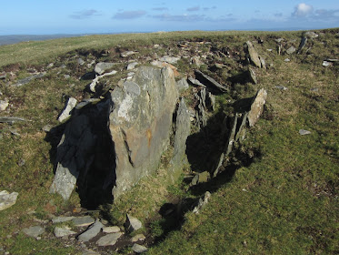

Outcrop of welded tuff (?) with quartz veining on the dolerite plateau west of the hill summit


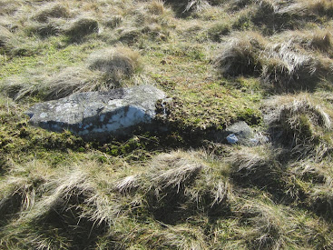

Small recumbent monolith near the eastern boundary wall of the common
Hi Brian
ReplyDeleteIt's difficult to know if they've found an arc because they excavated a circle. You mentioned (extract below) that there are other stones:
As pointed out above, the closest stones are just 50m away, to the NE, but there are others on the common to the NW, and several others along the edge of the common and along the roadway leading to Cilgwyn. Some of these have holes drilled in them, and have been used as gateposts. If there ever was a stone circle of smallish monoliths erected in shallow pits at Waun Mawn, it is possible that at least some of the local gateposts have been "stolen" from one or more stone settings. Again this possibility has been completely ignored by the excavation team -- they have been so preoccupied with Stonehenge that they have not even looked for anything of interest in the local landscape.
I can see on OS the stones to Cilgwyn (and in addition to your list some other nearby standing stones to the ESE and SSE at about 200 and 300 metres respectively), but can't find an obvious location for the ones to the stones just 50m away to the NE and the other group on the common to the NW. Do you have any location data on where these are?
Jon -- the stones along the road are easy to find, using Streetview, I suppose. I haven't bothered top plot them individually. therev are a couple of really nice huge slabs as well, made of the meta mudstone, at the roadside.
ReplyDeletei don't have a mobile with GPS positioning on it, I'm afraid. But the 2 dolerite recumbent stones are easy to spot in the turf. Just walk NW (approx) from the standing stone and you will find them. The other recumbent can be found by just following the boundary wall downhill towards the cattle grid. I doubt that you'll pick them up on a satellite image......
Thanks Brian
ReplyDelete