1. Now that the dig has been extended for 70m or more, right to the inner end of the rocky spur, we can see that the dig site is on the floor of a small meltwater channel, similar to many of the features we can see on the flanks of the Gwaun-Jordanston meltwater channel system. It's difficult to assess how many times this channel might have been used, but its use by meltwater (probably subglacial, under very high pressure) might go some way towards explaining the long, smooth, regular wall which others tend to refer to as "the quarry face." It's probable that the channel was used both in the Anglian and Devensian Glaciations.

View of the dig site, looking along the rock face of the spur towards the top end of the meltwater channel. In the far distance the channel loops round to the left and rejoins the main meltwater channel now occupied by the Brynberian River.
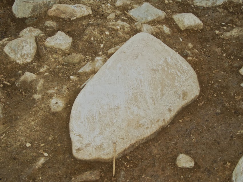
2. If you look carefully at the photo above you can see that the big "orthostat" resting just to the right of centre in the photo has fallen from the highest pinnacle on the ridge. I see no problem at all with a slab of this size crashing down the rock face, either in the Late Glacial or at some stage during the Holocene, and ending up exactly where it is today, some distance from the rock face. It might have slid, might have tumbled down end over end, or might have rolled. No human agency required in the process.
3. In his Moylgrove lecture, MPP placed great emphasis on the "killer fact" that a big transverse stone just downslope of the "proto-orthostat" has striations or erosional grooves on it, proving beyond doubt that other large stones have been hauled across it during earlier stone removal operations. It's lucky that I managed to have a look at it today, or this myth might have been perpetrated until the end of time -- and there would have been no way of checking, since the spoil is about to be thrown back into the dig location at any moment now.............. Anyway, they are not striations, scratches or erosional grooves. They are outcropping foliations on the rock surface, no different from those on scores of other stones to be found throughout the dig site. They follow the strike of these micro-structures. If you look at the side of the rock you can see how the foliations or "pseudo-layers" run within the rock, downwards towards the bottom left of the photo. I am 100% confident that any geologist or geomorphologist who looks at this rock would agree with me on this. Here are some pictures:

Above: Close-up of the "grooves" supposedly caused by heavy orthostats being dragged across the stone in question. There are indeed grooves, but they coincide exactly with the outcropping foliations on the stone surface. They are perfectly normal weathering phenomena, of no significance whatsoever to the quarrying debate.

Above: Another grooved block of rhyolite embedded in till in the lower part of the dig site. The grooves on this one are seriously interesting, since they are slightly curving and since they don't seem to be related to the pattern of outcropping foliations. This one has "glacial erosion" written all over it.

Above: More grooves on the end of another slab of local rhyolite, not far from the "proto-orthostat." These grooves are very prominent, and are clearly related to the pattern of outcropping foliations.

Even more interesting -- and something you don't see very often in Pembrokeshire. This is a heavily glaciated slab of rock on the lower part of the dig site - look at all the smoothed off corners. But look even more carefully at the crescentic gouges or fractures. If you are a geologist you might call them conchoidal fractures. They show that a glacier with very hard tools has been at work on this surface.
4. In the Moylgrove lecture, MPP also dismissed the idea that the excavation had reached a layer of till. He said that if there was till present, it must be much deeper down. I have news for him. In the lower part of the dig at the moment we can see some of the best till I have seen in a long time. In fact, they hit it last year, as I mentioned on this blog. (Why don't these people listen when they are given solid information?) It is probably Devensian, around 20,000 years old. Its upper surface -- as always in Pembrokeshire -- is a foxy red colour. When I saw that I was pretty convinced that I would see a rather sticky clay-rich or silty till underneath the reddish layer, and indeed, there it is for all to see:

The lower part of the dig site. In the foreground we see a cluster of rhyolite boulders which have been embedded in the Devensian till. The foxy red colour is typical of the weathered upper surface of the till everywhere in Pembrokeshire. Deeper down, the colour changes, and there are signs of gleying, with streaks of buff, grey and black colouration. I'm not sure whether the black colouring is due to manganese oxide or organic material. We can see this if we look carefully at the section beneath the white labels -- bottom left. There is not a huge amount of clay in this till -- it is more sandy and gravelly. Again that is typical of the inland tills in Pembrokeshire. On the north coast, where the ice has come in from the sea, the clay percentage in the Irish Sea till is substantially higher.
5. I may be wrong, but I get the impression that when archaeologists look at erratics, they see hammer stones. I'm not denying that there may be the odd hammer stone lying about on this site, but what is indisputable is that we have a splendid collection of rounded, sub-rounded and shaped glacial erratics representing many different lithologies. I counted five or six different rock types very quickly, but did not wish to disturb any of them for fear of messing up the survey work. The most prominent are the blocks of quartz (very rough and jagged, since quartz is almost impossible to smooth off nicely except on a beach or in a very turbulent river), several types of dolerite, and several types of volcanic ash. Probably they have all come from the NW, where the rocks of the Fishguard Volcanics are exposed at the surface. Some of these are small enough to use as hammer stones, if you were determined enough to bash something, but many of the boulders are far too large to be lifted, let alone used for percussion or stone shaping. You can see some of these stones in the photos posted by Chris: http://chrisjohnsonnl.smugmug.com/Rhosyfelin-2013-dig
Many of them are still embedded in the till, and others have been lifted by the digging team and slung onto the spoil heaps. Here are a few of them:
Large erratic boulder embedded in the till in the lower part of the dig site. This is probably a dolerite.

Another erratic boulder resting on the surface of the till. This also appears to be a dolerite.

A large quartz erratic boulder, upslope of the "proto-orthostat." This one could have come from almost anywhere in North Pembrokeshire........

How many more erratics do you want to see? I won't bore you with any more close-ups, but here are a few that the diggers have extracted and pushed to one side.
So there we are then. If anybody tells you that there are no traces of glacial action at Rhosyfelin, do not believe them. Trust me. I know what I am talking about. Always happy to help. And by the way, I'm still waiting to see some evidence that this site was used as a quarry.
Brian,
ReplyDeleteI'm actually with you on several of these points. Good work.
Can you give us a better sense of scale in your photographs.
Glacial erratic or hammer stone ... whatever - how big is it?
Thanks,
Neil
Sorry Neil -- you are quite right. I should have placed a pen or something in all the photos for scale. The biggest erratic is over 24" long, and some of the others are over 12" long. Between 100 kg and 20 kg maybe. Many are far too heavy for one man to lift on his own -- and there is no way they could be used as mauls or hammer stones.
ReplyDeleteBrian,
ReplyDeleteSo now we have proof the Rhosyfelin Crag was engulphed in water with channels running on both sides of it. What I have been arguing in this blog for nearly a year. Here are a couple of quotes from my comments under your http://brian-mountainman.blogspot.com/2012/11/rhosyfelin-is-it-quarry-site.html post.
” I am intrigued by the flat smooth polish of the N-W face at Rhosyfelin ... Could these have been cut and polished by meltwater torrents streaming down that side shaping the smooth N-W side” (26 November 2012 17:58 )
”The tapered wear of the [Rhosyfelin] NW face – shorter downslope – also indicates to me meltwater torrents were mainly responsible for the polish. The river further down from that point also adds to this impression. So does the larger landscape view in one of your aerial photos. You could clearly make out the outlines of the banks of a larger wider river running through this site and shaping the Rhosyfelin outcrop. And from the looks of this, it doesn't seem to me this wider river existed all that long ago in the past. Possibly postdating Stonehenge. If so, how could Rhosyfelin conceivably be a 'human quarry' for Stonehenge stones? The presence of rhyolite fragments found at Stonehenge and traced to Rhosyfelin must have other more sensible explanations. “ (27 November 2012 03:00 )
The soil deposits (some one meter deep) by the foot of the NW face are likely meltwater stream deposits and probably not slope deposits as you had argued a year ago! And if the carbon dates MPP has been concealing postdate Stonehenge (what MPP may be calling Iron Age evidence), that would explain why MPP has not released them to the world!
To me, it's all sensible logic! But you can call me a profit if that makes you feel any better.
Kostas
Brian This is all very useful but SHOULD go into the formal literature.
ReplyDeleteBlogging is not enough, even a short note somewhere. I don't know the Pleistocene journals but they must have such brief communications.
The erratics are most convincing and I am happy to see the strat you suggest (I have never quite 'got' gleying').
The relationship between the foliation and gouging I shall have to look at carefully.
The relationship between the proto-orthostat and top of the outcrop, can we see a photo taken at 90 degrees to them both.
It is a great shame and to everyone's impoverishment that you were not part of this research. We all share the blame, nobody is guiltless.
Formally having your expertise recorded is the best reasonable outcome possible.
The blog can and will be dismissed,a formal, peer-backed note is your duty.
Rob Ixer
I have been wondering about the big quartz boulder, the size is indicated better in one of my pictures.
ReplyDeleteMPP said last week that "there are many quartz boulders in Pembrokeshire" and he is right. Almost certainly this one in this position is the result of natural forces, but the fact that the quarry builders left it untouched is curious. At Glandy Cross and other sites there are indications that quartz was valued by monument builders. At the very least this boulder must have been in the way.
Thank you Rob -- yes, I agree. Am working on it, but it's not easy, since I have never had a chance to examine the site properly or to examine samples, or to know what pedological work or C14 dating has been done.
ReplyDeleteI know that this blog entry will be dismissed, but it is probably subject to much greater peer review (by you lot!) than Chapter 17 in MPP's book, which was probably not peer reviewed by anybody!! With book manuscripts, you might have a fierce editor, but otherwise you can get away with almost anything......
Chris -- there are / were several quartz boulders at the site. I think the others have been removed by the diggers. I showed some pics of them in my review of the 2012 work.
ReplyDelete"I see no problem at all with a slab of this size crashing down the rock face, either in the Late Glacial or at some stage during the Holocene, and ending up exactly where it is today, some distance from the rock face. It might have slid, might have tumbled down end over end, or might have rolled. No human agency required in the process."
ReplyDeleteAbsolute nonsense!
http://brian-mountainman.blogspot.co.uk/2013/06/a-long-history-of-rhosyfelin.html
Clearly rearranged by man (just take a long look at your picture and where the other 'orthostats' have landed), what is at question is the date.
Mike
Mike (not sure which of several Mikes you may be). OK -- agree with you about human arrangement in the picture referred to. Now for the problem of the date. Was it 2012, or 2013?
ReplyDeleteMike Anon,
ReplyDeleteThe lying “orthostat” may be where it is while the other “orthostats” are where they are because it was the last to fall! And possibly over a snow embankment covering the other stones along the rockface; forming sled tracks as it were and softening the fall. Just look how “fresh” it looks. Not a sign of wear and tear! Not even from “quarrying”!
Kostas
Kostas,
ReplyDeleteYou say ----
"Just look how “fresh” it looks. Not a sign of wear and tear! Not even from “quarrying”!".
The wear and tear would be on the bottom face of the rock and therefore hidden from view.
Phil Morgan
Phil,
ReplyDeleteThe bottom face would be the part of the “orthostat” once attached to the Crag. As such, I imagine there would be some roughness to it; unlike the top face which probably was part of the smooth rockface surface. But beyond such expected bottom roughness, are you arguing for greater “wear and tear”? How do you know that! But the sides in full view clearly show no such “wear and tear” as would be expected from human stone work.
Are you disputing the natural action I outlined above explaining the position of the lying “orthostat”? If so, please explain your reasoning.
Kostas
Formally having your expertise recorded is the best reasonable outcome possible.
ReplyDeleteThe blog can and will be dismissed,a formal, peer-backed note is your duty.
Rob Ixer
It's an interesting point: But why is it Brian's duty?
I have heard no arguments for the proposition that this archaeological investigation serves a societal purpose. I agree that writing a peer reviewed note might possibly help the venture. But if it is true that this commercial venture has no potential benefit to society, what duty is there on Brian to gift his time to it (other than on his blog)?
Brian,
ReplyDeleteConcerning these “grooves” in some stones that MPP takes as evidence of “human activity”. In what position and orientation relative to the rock face are these stones and these “grooves”? Couldn't these “grooves” have naturally formed by meltwater flowing over these rocks? And wont such water flow also account for the rounding of the edges of some stones lying along the spur?
Wont this then suggest these “orthostats” were submerged in water and the Crag engulfed and therefore couldn't possibly have been a “quarry”?
Kostas
Kostas -- on the top photo, you see the "orthostat" with a largish stone near the near (downslope) end. Its long axis is approx perpendicular to that of the bog stone. That's the stone upon which the "grooves" are found. The alignment of the grooves is more or less parallel with the long axis of the big stone -- and this fact has of course led the archaeologists to claim that the grooves are from wear and tear arising from other large stones being dragged downslope.
ReplyDeleteGrooves like this would not be cut by meltwater -- but it is possible that meltwater has played some role in the rounding off of the edges of many of the stones found in the dig site.
ReplyDeleteThanks for the comments, Jon. This matter of "duty" is a difficult one -- I would like to do a note, but of course I have no original research to base it on. Just a few brief visits to the site over the past 3 digging seasons, and a few chats with people involved in the dig. A far grater duty rests on the shoulders of the digging team to be open to multiple hypotheses, and to use the Occam's Razor principle to go for the simplest explanation of the features observed -- ie that they are all natural, with no human involvement. If that explanation does not work, then go for the next simplest one...... which is that Rhosyfelin was a Neolithic camping site used by hunters.
ReplyDeleteBog stone? Freudian slip -- should be "big stone".
ReplyDeleteThanks for the comments, Jon. This matter of "duty" is a difficult one
ReplyDeleteQuite right. It's something that is of quite an interest to me. The idea of duty applies where there is some form of benefit to someone else or society in general. As far as I can tell, the project is privately funded and has no mission statement which includes possible public benefits. So I can't see how a duty could be applicable.
There is a secondary consideration: Where you know that there would be a public benefit to gifting your advice, but the people doing the work do not know what that benefit would be. This is a circumstance under which you may have a duty: Particularly if, by omission, you would cause harm.
However, omission to supply information to MPP's team would be a case of failing to generate a benefit rather than causing harm. There are many circumstances in which failing to generate benefit would not apply as a duty. For instance, the development of medicines is based on a business model in which those undertaking development may cause a failure of their own industry if they were to respond to every call of duty. So in these instances, the call of duty does not apply.
Onus of duty is surely with the official geologists and geomorphologists presented as part of the team and listed on the project web page?
ReplyDeleteIf I was them I would want to be sure that I had responded to the several serious remarks made by Brian and others while formulating any final judgements. Whoever makes a judgement on this will be under scrutiny for the next 100 years or longer.
Brian does not mention the river flooding effect, perhaps because it does not have anything to do with the ice age. The ford shows clearly that the river can rise to 6 feet, thus inundating the fireplace and lower levels of the site regularly. Who knows what material might be washed down from higher up and deposited there - flint fragments, bits of pottery, organic residues?
I think the final report has a tough challenge to present this site as simple and well-preserved. Probably takes many years to produce, if ever.
Agreed. Nice summary Chris.
ReplyDeleteYes, the river does go up and down by maybe 6 feet in extreme flood conditions. And in extreme wet spells, there would be a lot of hillwash as well -- but this will show up in the rather complex sediment sequence I have described in my little document placed on Scribd. I hope and trust that the archaeologists have got the stratigraphy well described and analysed -- and dated.......
ReplyDelete