

Briwgarn
Grid Ref SN006366. Alt 274m. This is the name given to a number of small ruined tors on the common to the south of Garn Fawr, on Dinas Mountain. The outcrops were clearly once much more extensive -- they have been effectively ruined by overriding ice. There are many spectacular perched blocks in the area, extending over c 20,000 sq m. There are other similar rocky outcrops -- all of dolerite -- on Mynydd Llanllawer to the east.


Carn Clust-y-ci
Grid Ref SN 043370. Alt 280m. This translates as "Dog'e Ear Carn", and indeed from a distance this is what it looks like. It's a small tor on the hillside to the east of the Bedd Morris minor road. Like most of the others on Carningli Common, it is made of grey unspotted dolerite; there are slight traces of banding. The rock here has similarities with some unspotted dolerite fragments found at Stonehenge, and it was thought at one time that this was a candidate site for the source of at least one of the Stonehenge bluestones; but more recent research suggests that this was probably NOT a source. The tor is surrounded by an impressive block field of scattered slabs and boulders broken up for the most part by frost-shattering and other periglacial processes.

Carn Cwn
Grid Ref SN 064383. Alt 134m. Carn Cwn means "the cairn of the dogs". This is a "lowland tor" on the hillside surrounded by thick vegetation and reached from the Cilgwyn Road by a footpath behind the cottages called Rising Sun and Temple. The footpath leads ups onto the common, and also passes Carn Llwyd (another with that name). There are other footpaths running from the network of lanes on the south side of Newport. It's easy to get lost! The tor is made of porphyritic igneous rocks formed in violent volcanic eruptions -- welded tuffs (ashes) and vesicular lava flows. Similar rocks occur along the northern flank of the upland all the way from here to the western end of Dinas, near Cwm Mawr. The elongated rock outcrop is a slightly spooky place, very shadowy in the winter, with huge detached blocks (some almost as big as houses), cliffs and deep crevices. It has folklore attached to it, and the seepage issuing from a horizontal fissure beneath a massive block of dolerite on the lowest part of the tor is reputed to have healing properties. Local children refer to it as "the wishing well" -- and to make a wish you have to slide your hand into the crevice until you encounter a pool of clear cold water. But beware -- there is one local story that says that many years ago a poor soul intent upon making a wish slid his hand in and was bitten by an adder for his trouble......


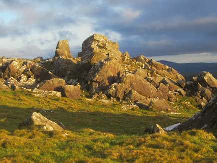
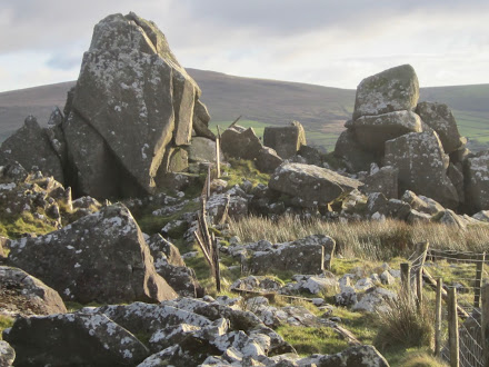
Grid Ref SN 055366. Alt 290m. This is one of my favourite tors. Actually there are two of them, separated by a grassy bank. Many a picnic has been enjoyed here, basking in the sun and sheltered from the wind. The crags are off the common, but adjacent to a public footpath, so there are no problems of access. You might see some longhorn cattle, but they are pretty placid. You see the tors quite clearly to your right when you are walking on the footpath that leads from Bedd Morris to Carningli. The tors are made of dolerite, and there are a number of ice-smoothed slabs in addition to the usual jumble of huge detached slabs and boulders and a complex morphology of intersecting crevices or fissures which have opened up as a result of glacial and periglacial processes. There are several rather spectacular perched blocks. On the south side of the eastern tor, against the rock face, there is a substantial semi-circular wall or embankment which looks as if it might be the remains of a hut. Is it prehistoric? There is no way of telling, but Dyfed Archaeology specialists think that this and others similar features in the neighbourhood are probably relics from the Bronze Age. On the common directly north of Carn Edward there are at least three "ring cairns" whose origins are shrouded in mystery.


Garn Fawr
Grid Ref SN 007368. Alt 305m. This is an impressive and somewhat sombre tor whose massive bulk dominates the open common to the west of Carn Enoch. With care, you can clamber up onto the top and enjoy the view. It's made of dolerite, and although some huge blocks have been detached from the core along fracture cracks, most of the tor has survived the depredations of time. Thye fenced boundary of the common runs along the flank of the tor, but there are easy approaches from the footpath running along the crest of the Mynydd Dinas upland ridge, from the car park near Glyn Gath.


Grid ref SN 005369. Alt 290m. This is a western extension of Garn Fawr, separated from it by a grassy patch littered with small bedrock outcrops and a litter of boulders and detached slabs. It's a prominent feature with outstanding crags and a steep west-facing cliff which is broken up into huge blocks, the largest measuring approx 10m x 5m x 5m (250 cubic m). Some of these certainly weigh over 700 tonnes. There are deep chasms, overhangs and even caves or cavities beneath these dislodged blocks. The tor has effectively been dismantled by overriding ice, and the most interesting feature (from the point of view of a geomorphologist) is the extensive area of glacially moulded or smoothed slabs, extending for over 400 sq m. These slabs are facing south, which is interesting, given that the ice here came from the north. There are some perched blocks resting on the slabs, and also traces of glacial grooves and crescentic gouges.


Another intriguing feature of this tor is a "plug" of dolerite with columnar jointing, surrounded by dolerite which is more massive, with widely-spaced joints. The plug is breaking up into a litter of small blocks which have fallen onto the surrounding slopes; but on one ice-smoothed rockface we can see the polygonal pattern of jointing very clearly.

Carnffoi
Grid Ref SN048379. Alt 213m. Here, at the northern edge off the Carningli Common, at a relatively low altitude, there is an extensive tor, broken into several widely separated crags, with all of the usual features: complex fracture patterns, detached blocks, ice-moulded rock surfaces, and accumulated scree and litter banks. It's very spectacular, and easy to access, since it lies just to the east of the Bedd Morris Road. The main crag has been incorporated into the defences of the roughly rectangular hill fort, assumed to date from the Iron Age. But it could be older. It's easy to scramble about on the defensive embankments. There are traces of other stone walls and structures as well -- some of these might date from later phases of occupation. There are local tales of the site being used as a base by one of the Irish chieftains who terrorised the district in the early Middle Ages.

Carn Fron
Grid Ref SN 016381. Alt 192m. This is a small and relatively unspectacular tor just 80m north of Carn Gwiber. It's made of volcanic ash and rhyolite. There are traces of ice smoothed surfaces, but the tor has been broken up into large slabs by glacial and periglacial processes. There are two separate crags, one of which is largely overgrown with brambles, ivy and bracken.

Carnedd Fychan
Grid ref SN 050373. Alt 286m. There are a number of craggy rock outcrops here, on the common to the west of Carningli. Three of the crags are quite prominent. To reach the site, follow any of the abundant sheep-tracks that run across cross the common from all directions. The crags are made of microtonalite or banded dolerite, and there is a considerable litter of broken slabs and scree. On some rock faces we can see columnar jointing. There are grassy banks around the little tors, and this is a perfect picnic spot and playground for adventurous small children - and adults. Gorgeous views to the west, where you can see Carnffoi, Pont Ceunant and the Bedd Morris Road down below. Note the fascinating pattern of sheepfolds, guide walls and enclosures on the lower slopes below the tors. Some of the stones for the building of these walls have come from the block field beneath the tors -- one can see signs of the "stone takes" on the ground surface.


Carn Gwiber
Grid Ref SN016380. Alt 204m. This small tumbledown tor is located on the northern flank of Mynydd Dinas, overlooking Dinas Cross. It's a wild place, hardly ever visited by walkers and almost overwhelmed by bracken and brambles. On its western flank there is a dry heathland called Y Bryn and dominated by gorse and dry grasses; this is a perfect habitat for adders, and indeed they Welsh word "gwiber" means viper. When I visited the tor some years ago, on a hot summers day, there were vipers everywhere, and I needed to step rather carefully.......... But my most recent visit was accompanied by snow showers, so the vipers were fast asleep in their winter hiding places. The tor is made of volcanic ash and rhyolite, and the broken slabs and vast boulders have such rough surfaces that there are few traces of glacial action. On the eastern flank of the tor there are steep cliffs which accord shelter from the westerly winds, and there are several prominent walls which may be prehistoric. The largest enclosure shown on the satellite image might have been used as a sheepfold, but one rectangular feature with a wall more than 2m high close to the rock face may actually have been a roofed building. The closest farmhouse to the east is Werndew, which was the residence of the famous local wizard or magician called Joseph Harries.


Carningli
Grid Ref SN 063373. Alt 346m (summit). It's perhaps absurd to classify Carningli as a tor, since it's also known as "Angel Mountain" and should be classified as a small mountain or large hill instead -- but although it is extensive (the rocky outcrops cover an area of 150,000 sq m) it has a wide range of tor-like features. There are abundant crags and cols, vast detached blocks, scree slopes, intersecting fractures, perched blocks, ice-moulded surfaces and exposures of several different rock types. The mountain is really the core of an ancient volcano which erupted in or near the sea back in Ordovician times, about 450 million years ago. According to the geological maps, the rocks here are largely intrusive -- classified as micro-gabbros or dolerites with a lot of variations in lithology. The main summit is made of micro-tonalite, a silica-rich igneous rock intruded into other rocks in a molten state. But if you wander about on the mountain you will find boulders of gabbro and rhyolite as well, so the geology of the mountain is still not at all adequately mapped. The mountain has been fashioned by many millions of years of denudation, which have stripped off most of the the extrusive or volcanic rock that must once have been present and also many of the surrounding sediments. During the Ice Age the mountain has been glaciated on several occasions, most recently during the Last Glaciation around 20,000 years ago. The summit was probably overridden by the ice of the Irish Sea Ice Stream which flowed down from the north and which was possibly thick enough to cover Mynydd Preseli as well; there are many ice-moulded slabs on Carningli, and these are particularly prominent on the northern flank and on the top of the rocky ridge near the southern end of the hill fort. On the south-eastern face of the mountain there are extensive banks of scree, with some accumulations in the form of lobes -- and it is almost certain that when the summit of the mountain was a nunatak there was a wide and rather spectacular windscoop at this location. The mountain summit has one of the best defended settlement sites in Wales, with stone embankments built to quite a sophisticated design, and a village with many hut circles at the northern end, overlooking the Nevern Estuary. Many of the man-made features on the common surrounding the mountain summit seem to date from the Bronze Age, but the "fortified village" was probably a feature of the later Iron Age settlement in north Pembrokeshire. Later on, in the Age of the Saints, it is said that St Brynach (who had his small monastic community not far away, in Nevern) came up onto the summit in order to "commune with the angels" -- hence the association with angels, and the long tradition that this is a sacred mountain.


Carningli Common
Grid Ref SN 058369. Alt. 1050 ft. To the SE of the burial cairn called Carn Briw there are a number of outcrops of dolerite stretched across c 300m of countryside. They are ruinous rather than spectacular, but I'm rather fond of them, as are innumerable small children -- there are nooks and crannies, wide rock slabs, perched blocks, grassy banks and a semi-circular arrangement of boulders that suggests a prehistoric shelter -- maybe used by the inhabitants of the Carningli "village". Less than 200m away, near the bend in the boundary fence, is the constant spring which some refer to as "Ffynnon Brynach" -- in early spring the pools are full of frogspawn.


Carn Llwyd 1
Grid Ref SN054371. Alt 320m. This small and rather unspectacular tor lies on Carningli Common, just 200m from the Bronze Age burial mound of Carn Briw. Like most of the tors on Carningli Common, this one is made of "banded" unspotted dolerite or microtonalite, and is very similar to that on the western flank of Carningli. Access is easy, with sheep tracks leading from Carn Briw. On the western (downslope) side of the crag there is a cliff about 15m high, with rockfall debris at its base.


Carn Llwyd 2
Grid Ref SN 062 381. Alt 189m. This is a small dolerite tor on the edge of the common to the north of Carningli. It's close to the main footpath that links the town of Newport with the mountain. It's made of banded dolerite similar to that of the other Carn Llwyd. It was once thought of as a possible source for at least one of the Stonehenge bluestones, but that conclusion is now disputed. It's in an area of abundant Bronze Age remains -- hut circles, stone clearance cairns, old embankments, walls and ditches, trackways and standing stones. Less than 50m away are the remains of a quarter-circle earthwork which has an outer ditch and an inner bank; it starts at a rock outcrop clearly designated as a part of a defensive structure, but after 50m or so it all just fades away, and for the rest of the circumference of what might have been a substantial feature, there is nothing. Clearly not all prehistoric projects were successfully completed.


Carn Sefyll
Grid Ref SN 011 373. Alt 252m. A small, isolated tor on the northern slope of Mynydd Dinas, to the north of Carn Enoch. It's made of dolerite, like all the other tors in this neighbourhood. It's much more spectacular when viewed from the north (downslope) side, with a very prominent cliff more than 15 m high. The bedrock here has prominent foliations or layers, picked out by weathering processes over the millennia. Like the other local tors, this one has been denuded by overflowing ice.

Carn Ty-col
Grid Ref 032368. Alt 274m. About 800m to the west of Bedd Morris, on the moorland known as Parc Mawr, there is an interesting cluster of ruined tors scattered over a distance of about 200m. They are made of dolerite. To the west there is a fascinating ruined enclosure, with the remains of an elongated cottage and garden. Was this a genuine "Ty Unnos" settlement, one the edge of the common? It's quite possible.


Parc Mawr
Grid Ref SN 035365. Alt 290m. On the common to the west of Bedd Morris, down on the north-facing slope, we can see a scatter of grey dolerite outcrops, some of which have strong surface expression. They are associated with dolerite sills or dykes, and there are signs of slight steps in the landscape. There are many ice-moulded bedrock slabs, detached blocks and huge rounded boulders scattered across the landscape, and these can be classified as "destroyed tors" like some of these on the main upland of Preseli. There are similarities with Cerrig Marchogion on the Preseli ridge. I'm not surprised by the rate of glacial destruction here -- in this slight col the ice would have streamed over the mountain, whereas over the ridge tops and summits it would have been almost stagnant, thereby protecting rather than destroying tors. The most extensive of the tors lies to the south of a fence; it's made of dolerite slabs and has a somewhat unusual form. There is easy access via the trackway leading NW, starting just north of the Bedd Morris car park. However, please note that many of these massive stones are not in their natural positions -- the local farmer has been involved in a massive "tidying up" operation, with the aid of some very heavy machinery.


Read with interest...thank you. I live in the middle of Bodmin Moor in Cornwall......surrounded by 'tors' and 2 miles across the moors from Bron Willeni (Brown Willy) and Rough Tor (pronounced 'row' as in 'cow'), the highest points in Cornwall at around 1400ft. I was in your part of the world in 2016 and my partner and I were about to trek up to the site in the Preseli mountains where the Stonehenge blue stones are presumed to have been taken from. We just set our feet on the footpath when the heavens opened with the biggest heaviest rain I have ever experienced (even in Cornwall). It rained solid for over 12 hours. We had to turn back to the van and never made it to the top. It was our last day of holiday so no second try. Will be back to your beautiful land another day. I'm not a geologist but I know a bit about rock types and land formations so thanks again for the blog.
ReplyDeleteThanks for the comment. As you may know, I don't believe that the bluestones were "taken" from anywhere -- there are between 20 and 30 different types of bluestone represented at Stonehenge, in the standing stones, stumps, debitage and clutter of packing stones etc. There could not have been that many quarries -- so the assemblage is almost certainly a collection of glacial erratics dumped at, or near, Stonehenge.
ReplyDeleteI think it would be a real pity if this information, and that in your Preseli Tors post, didn't get published in book form. You've obviously done a huge amount of research which shouldn't be allowed to get lost in the archives of this blog. A book could be a valuable companion to Paddy Figgis's Prehistoric Preseli, but it would also stand on its own feet. There's been a lot of nonsense written about the Preselis, and we could do with a balancing account. You would certainly have one guaranteed sale, and I hope you'll think again about publishing.
ReplyDeleteThanks Steve. My wife has been saying the same thing to me, and I am indeed working on a version that will be issued as an Ebook, probably for the Kindle. It's easier to do now that the Amazon software allows the upload of PDFs of complicated pages. Watch this space! The production of a physical book is more of an issue, since short runs are still horribly expensive -- but I am looking at that too......
ReplyDeletePerhaps a spot of crowd funding for the book? On the other hand most of my books these days are e-books. I use Apple Books and it is possible to publish a PDF there I believe - at least I have many PDFs on Apple Books for ease of reference.
ReplyDeleteThanks Chris. Yes, publishing physical books is very risky nowadays, with everything digitised and on line. But I have never looked at Apple Books -- will check that out........
ReplyDelete