Features seen on Höga Kusten, Sweden, around and beneath the 260m marine limit. Kalottberg hills are "capped" with moraine and glacial and fluvioglacial deposits, providing excellent conditions for forest cover to survive. Beneath the highest strandline surfaces are washed -- which means that most of the fines have been washed out during isostatic uplift.
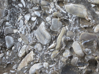
Beneath the highest shoreline in the Höga Kusten district, the finer materials in the morainic cover are washed out, leaving massive accumulations of boulders and smaller stones. The term "Klapperfält" is used to describe them.. Most of the boulders are local, but scattered among them are far-travelled erratics, coloured orange in this diagram. In areas such as this, stillstands or pauses in the rate of uplift may result in the formation of storm-beach ridges.
Erratics of many different lithologies on washed rock surfaces in the Stockholm Archipelago.
Washed surfaces, kalottberg and klapperfält features can be found anywhere within the dark coloured area on this map.
It's intriguing that ice-rafted erratic boulders are still being talked about in the context of the large erratics found on the shorelines of southern Britain. Ice rafting seems to be the "process of preference" among those who -- for whatever reason -- do not wish to accept that full glacial processes have substantially affected the Bristol Channel coasts of Cornwall, Devon and Somerset.
About a year ago I posted these items on the blog:
https://brian-mountainman.blogspot.com/2023/12/coastal-geomorphology-in-devensian.html
https://brian-mountainman.blogspot.com/2023/12/the-big-erratic-boulders-of-devon-and.html
........... and I have discussed the matter in many other posts as well. Use the search box to find them.
The latest spat is with James Scourse, who argued in a very strange paper that the big coastal erratics were emplaced by floating ice at a time of high relative sea level (RSL) and cold climate.
https://brian-mountainman.blogspot.com/2024/03/new-scourse-paper-on-giant-erratics-is.html
That of course flies in the face of our understanding of eustatic / isostatic relationships during the Devensian and earlier glacial episodes. In the latest rather crude attack on me by Pearce, Ixer, Bevins and Scourse they argue again that the big coastal erratics (like the Limeslade erratic) on the Bristol Channel coasts are "ice rafted" -- and that there was "asynchrony between Early and Middle Devensian regional ice sheet development and global sea level". I don't have a clue what that means, and no evidence in support of the contention is provided. I see no sign at all of Early and Middle Devensian glacial activity in the Quaternary stratigraphy of West Wales, and I see no evidence of substantial isostatic depression at the time, or tectonic tilting. Bennett et al, in the new paper on the Quaternary in Devon, say with respect to the coastal erratics: "...........another view is that the coastal platform erratics were delivered by icebergs calved from glacier ice farther north, an interpretation that is consistent with the widespread distribution of erratics on shore platforms on the Bristol Channel and English Channel coasts."

Even if there was a substantial ice mass in Wales during the Early and Mid Devensian, global sea level at that time was around -70m, and I can see no mechanism for a sinking of the Devon and Cornwall coast by an equivalent amount, thereby creating conditions for ice rafted debris to be dumped on the coastal rock platform. On the contrary, when one looks at known isostatic adjustment mechanisms, there would have been a hinge line along the Bristol Channel and a rise in the relative altitude of the South-West Peninsula, making giant erratic emplacement from floating ice even less likely.
Icebergs do not, in general, deliver erratics to distant coastal platforms. Dirty icebergs moving away from floating ice fronts almost always operate in deep water, dropping their debris load as a consequence of bottom melting -- ending up as glacio-marine sediments with added dropstones. There are vast thicknesses of these materials in the Celtic Sea and in the outer Bristol Channel. (They have received impressive attention during the BRITICE studies.) Icebergs do get stranded in embayments in the intertidal zone, and they do break up into bergy bits and release big boulders onto mud flats. But most of the ice with "rafting" characteristics is sea ice which develops as flat sheets and then gets broken up by lateral pressure, and broken ice floes are almost always clean. Where there is an ice foot on a polar coastline, it is almost always a mixture of sea ice, frozen spray and detached chunks of winter snowbanks. It sometimes contains erratic boulders, but these are generally taken from pre-existing coastal materials including beach accumulations, till and scree. They are seldom carried in from the sea; they are more likely to be carried OUT from the coastline to be dropped in deeper water offshore.
As I see it, the big erratic boulders scattered along the coasts of the Bristol Channel are NOT all concentrated in the current intertidal zone. They occur at altitudes up to at least 80m. They have to be residuals or remnants of ancient glacial deposits scattered along the Bristol Channel coasts. As I have said before, the "concentration" of these erratics on the intertidal rock platform is more apparent than real, since these are washed surfaces similar to those associated with "kalottberg" hills around the marine limit in Sweden. Nobody ever suggests that the boulders found at the marine limit are unique in any way; they almost always also occur above and below the limit. So the position of the marine limit -- like RSL on the coast of the Bristol Channel -- is interesting but not geomorphologically significant.
https://brian-mountainman.blogspot.com/2018/07/kalottberg-features-in-northern-sweden.html
It seems to me highly likely that the erratic boulders on the Bristol Channel coasts are simply the remnants of ancient glacial deposits that have been almost entirely removed on the coast by marine, periglacial and other processes, possibly over several glacial / interglacial cycles. Further inland, away from the coast, there may well be in situ glacial deposits (with giant erratics!) still awaiting discovery.
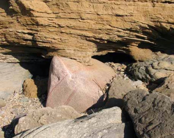
The boulders themselves may date from a number of different glacial phases, including the Anglian, Late Wolstonian and Late Devensian, in which Irish Sea ice from the N and NW crossed the coastline and pressed inland via convenient depressions and wide valleys. Just a few of the boulders (such as the famous pink erratic at Saunton) can be tied into the stratigraphic sequence, sealed by sandrock or slope breccia. At Whitesands in North Pembrokeshire the boulder bed (which I think is related to some of the erratics on coastal rock platforms) appears to consist of boulders emplaced prior to the last interglacial and then modified by wave action. It is not visibly associated with the Ipswichian raised beach.

Some of the boulders of the Whitesands boulder bed, held in cemented slope breccia at the base of the Devensian sediment sequence. The boulders were probably emplaced during an early glaciation and rounded by wave action during the Ipswichian interglacial. This narrative probably applies to many of the Bristol Channel "giant erratics"........
Looking again at the ice-rafting hypothesis, I cannot see any tectonic or other evidence which suggests that floating ice was involved in the emplacement of any of the big erratics on the Bristol Channel coast. On those occasions when there were dirty icebergs in the Celtic Sea, sea level was probably at least 100m lower than today, and the coastline was at least 10 km further to the west than it is now.
One from the archive. A "boulder bed" (including some well rounded ones) on a washed surface -- in part of the raised beach sequence on King George Island, South Shetlands. Photo from 1965. The marine limit in this area is at c 275m. There is no reason to believe that |"ice rafting" had anything to do with the presence of these boulders. They have all come from in situ glacial deposits.
Ice cliff resting directly on the current storm beach, at the eastern end of South Beaches, Byers Peninsula. Livingston Island. The ice is at the edge of a glacial dome called Rotch Dome -- it does flow seawards, but not very fast. Some of the ice is dirty, so debris is dropped onto the beach in frequent cliff collapses. We walked along this beach on one occasion, to look back and see a large ice collapse which obliterated the beach across which we had just walked.......


