After the winter and spring storms, even more rock exposures can now be seen along the northern edge of Abermawr Bay (on the western flank of the Pen Caer peninsula). This is one of the most important Quaternary sites in the British Isles, so anything that adds to our knowledge of past events here has considerable significance. It is now clear that since I started my research work here in 1962 the coastline has retreated between 10m and 20m. When I was working here in 1962-65 none of the rock faces exposed in this photo were visible. All were masked by thick pseudo-stratified slope deposits which I referred to as rockfall debris and "lower head" accumulated during a long period of Early and Middle Devensian cold climate. The erosional features seen in this photo on the rocky cliffs (caves, stacks, smoothed surfaces, wave-cut notches etc) cannot possibly have been formed over a period of just a few months, so they must be pre-Devensian. They are ancient "fossil features" -- first buried, and now exhumed. They must also be older than the Ipswichian or Eemian raised beach which sits on fragments of a wave-cut platform on top of the cliffs.
So the assumption must be that we are now seeing the exhumation of a pre-Ipswichian cliff-line formed at a time when sea-level was approximately as it is today.
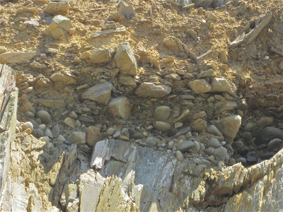
Next, the exposure of the Aber-mawr Ipswichian raised beach becomes clearer and clearer. Here is my latest photo, taken as a long shot from the beach below.
We see a jumble of well-rounded boulders and cobbles, with a maximum thickness of about 1 m, overlain by angular rockfall slabs and gravelly debris and then by lower head. As far as one can see, the raised beach is uncemented. It looks very similar in appearance and stratigraphic position to some of the raised beaches in the Isles of Scilly.
Here is another photo, showing where the raised beach exposure is located. The rock platform exposure is fragmentary and it looks irregular, but there is enough of it exposed now to suggest that it extends for maybe 20m along the top edge of the rock cliff, about 6m above current HWMST. If erosion continues at the present rate, it will soon be possible to scramble up to it and examine it in much greater detail.
The raised beach is exposed at the top of the rock cliff,just above the centre of the photo, in a
slight gully.


1 comment:
Just down the road from my brother. Have encouraged him to read this - he pays great attention to and loves the natural landscape and is a professionally trained photographer.
Post a Comment